Monument fire in Arizona burns or damages 40 homes

Update: on June 21 we posted more information about the Monument fire, including a current map.

========================
Update: on June 16 we posted an updated article about the Monument fire.

=========================
Update at 7:33 MT, 6-15-2011:

Teresa Jun, a reporter for KOLD, said via Twitter about 20 minutes ago that she is at a public meeting and was told the fire has burned 9,300 acres. She said about 1,000 people were packed into the meeting room in Sierra Vista to hear about the fire. Strong winds are forecast for Thursday.

Added a time-lapse video.

Right now, a live streaming web cam is showing the fire.
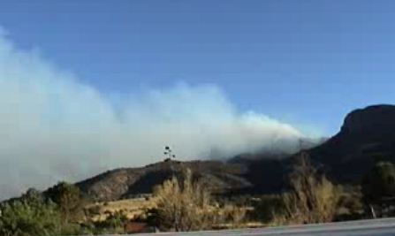
Monument fire
Monument fire, from live feed at 7:33 p.m. MT, 6-15-2011

=========================

Still another fire in Arizona has developed into a serious, destructive incident. The Monument fire eight miles south of Sierra Vista started on June 12 and has blackened over 5,000 acres, burned or damaged 40 homes, and crossed the international border from Arizona into Mexico.

Scroll down to see maps of the Monument fire, but here is information from the Cochise County Sheriff’s Office, at 5:16 p.m., June 15:

Structure Damage/Loss:

50 structures (40 homes and 10 other structures) determined as of this time, damaged or lost in the Ash Canyon area including the listed roads: Ash Canyon Road, Muffin Lane, Deer Trail, Prince Placer, Acorn, Pickett Lane, Twin Oaks, Mountainview, Stoneridge, Turkey Track and East Spring Road. Additional assessments will be completed throughout the day.

Closures/Evacuations:

Ash Canyon, Hunter Canyon, Stump Canyon (both upper and lower), Turkey Track will remain closed until further notice.

Mandatory Evacuations:

West of Highway 92: Hereford Road to Ash Canyon Road. This includes East Flying V Lane East Miller Canyon Road, East Hillcrest Drive, East Bristlecone Lane, East Oak Haven, East Hunter Canyon, East Baumkirchner Road, East Stump Canyon Road, East Spring Road and South Deer Trail.

West of Highway 92: Hereford Road to S. Circle Drive and South to East Pioneer Lane to include Cave Place, Haul Drive, Davis Street, Shirley Drive, East Corral Drive, Madelein Drive, East Bricky Drive, East Roger Drive, East Linda Vista Drive, Olive Lane, Calle Coyote, East Antler Trail, La Paloma, Sunnyvale Road, Valley Vista and Pioneer Place.

People are encouraged to leave immediately.

Here is a link to a map that shows all of the large wildfires in the United States.

Maps and a time-lapse video of the Monument fire are below:

Continue reading “Monument fire in Arizona burns or damages 40 homes”

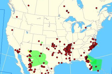
Wildfire smoke map, June 15, 2011

Smoke map, 1557, 6-15-2011
Smoke map, 1557, 6-15-2011. The red dots are fires, while the smoke is green (thin), yellow (moderately dense), and purple (dense). NOAA

Today’s map showing the distribution of wildfire smoke across the U.S. looks a lot better than it has since we looked at it last. Part of the reason is that at least 60% to 70% of the Wallow fire is not actively spreading. Wallow fire officials are calling it 20% contained. (Update: the official containment was raised to 29% at 6 p.m. on Wednesday.)

The National Wildfire Coordinating Group’s definition of “Containment”:

The status of a wildfire suppression action signifying that a control line has been completed around the fire, and any associated spot fires, which can reasonably be expected to stop the fire’s spread.

Some fire teams confuse that with Control, which the NWCG defines like this:

The completion of control line around a fire, any spot fires therefrom, and any interior islands to be saved; burned out any unburned area adjacent to the fire side of the control lines; and cool down all hot spots that are immediate threats to the control line, until the lines can reasonably be expected to hold under the foreseeable conditions.

Senate hearing about wildfire management

On Tuesday the Senate Committee on Energy and Natural Resources held a hearing “to consider the wildfire management programs of the Federal land management agencies”. The Departments of Agriculture and Interior both had representatives provide testimony and answer questions from the Senators. The representatives were Kim Thorsen, the DOI’s Deputy Assistant Secretary for Law Enforcement, Security, and Emergency Management (her written testimony), and Tom Tidwell, Chief of the U.S. Forest Service (his written testimony). As far as I know a transcript of the full hearing is not yet available.

A video of the hearing can be found at the Committee’s web site. The first 18 minutes shows a mostly empty room; the hearing actually begins at 18:00.

The Senators had vastly different points to make and questions to ask. Senator James Risch from Idaho bragged that he was probably the only Senator in the room that had a degree in forest management and that he had operated a Pulaski.

Senator Jon Kyl from Arizona talked about the fires currently burning in his state and that he thought the agencies should concentrate more on fire prevention, which would save money on suppression.

Senator Lisa Murkowski from Alaska has dogged the USFS for years about the state of the air tanker fleet and continued to do so in Tuesday’s hearing. Here is a portion of her statement/question, which begins at 26:00 in the video:

In 2003 we asked the Forest Service to tell us, what do you need to replace the heavy firefighting aircraft that were grounded in 2002? It took 10 years to develop an answer. And when it came it was with a $2 billion price tag during a time when the Congress was cutting the federal budget by 15% to 20% and it included no recommendation as to how we were going to pay for it.

Even more frustrating is that the agency seems to be fixated on one aircraft type and refuses to consider any other alternatives. Last month Chief Tidwell told me that the Forest Service would work to acquire a variety of aircraft types but his staff continues to tell people that the agency will only accept an aircraft that can carry 2,000 gallons of slurry. I just don’t understand why the Forest Service continues to tell the aircraft manufacturers and others here in Congress that whatever the aircraft it acquires it is going to need to carry 2,000 gallons of slurry.

So my message to the land management agencies is this. Develop a procurement plan to replace the aging aircraft that looks at a variety of types and sizes of aircraft. Develop a plan that has the flexibility to drop slurry, foam, gel, or water. Develop it to take advantage of the lakes and rivers that hold millions upon millions of gallons of water that could and should be dropped by water scooping aircraft. And finally do not ignore the opportunity to keep the existing fleet operational longer.

Later she asked more questions about large air tankers and about the use of Very Large Air Tankers (VLAT), the DC-10 and 747, suggesting that the USFS look at using the VLATs. Chief Tidwell said his agency would do so.

Tidwell also bragged that the USFS had used the DC-10 on the Wallow fire in Arizona. He failed to mention that it was only possible because it was borrowed from CalFire. The USFS currently has no contracts with any VLATs, and has refused to even consider exclusive use contracts for them like they have with the 19 large air tankers, offering the VLATs just call when needed contracts that would only pay if and when the aircraft were activated and used on individual fires.

Senator Murkowski also mentioned the recent article in the Washington Post titled “Firefighting planes have perhaps been on the job too long” that Wildfire Today covered on June 13.

Interestingly, Chief Tidwell reading from his pre-submitted written testimony, deviated from it by adding at the end, at 41:50 in the video:

In closing I want to touch on the issue of large air tankers. Large air tankers are an accepted part of wildland fire suppression, but our current fleet averages more than 50 years old. In the next 10 years more than half of our large air tankers will need to be replaced and we are studying the options and will be making a recommendation to you by the end of the summer.

Excerpts from the DOI about resources available in 2011:

Continue reading “Senate hearing about wildfire management”

Fire burns through administrative area in Carlsbad Caverns National Park

The National Park Service’s Morning Report has an excellent report on the Loop fire, which burned through the administrative area in Carlsbad Caverns National Park in southern New Mexico on Monday:

=======================

Carlsbad Caverns National Park (NM)

Park Closed Due To Loop Fire

At about 2:30 p.m. on June 13th, a report came in about a fire on the Walnut Canyon Scenic Loop Road within Carlsbad Caverns National Park.

Employees from Carlsbad Caverns and neighboring Guadalupe Mountains National Park responded immediately and tried to extinguish and contain the blaze. At this point the fire was only about three miles from the visitor center and heading in the direction of the main entrance road and other park facilities. Vegetation was tinder dry and easy to ignite because the park has received no measurable precipitation for eight months and had baked under the hot New Mexico sun.

Pushed by a hot, dry wind, the Loop Fire spread rapidly. By 3:30 p.m., park management announced the park was closing and visitors were directed to leave. By 4:00 p.m., employees and park residents were instructed to evacuate.

In these first hours, there was an urgent concern for hikers and researchers known to be in the backcountry. Luckily, the groups were contacted, accounted for, and left the park. Meanwhile, facility management employees stretched water hoses throughout the housing, maintenance, and historic areas and began soaking them. Volunteer and paid fire engines and crews from around the region responded quickly. At 10:00 p.m. the Pecos Zone Type III incident management team took over management of the fire. The cause of the fire is under investigation.

Twenty-four hours after it started, the Loop Fire was estimated at 16,000 acres and 10% contained. The terrain is rugged and steep; the fuel type is piñon-juniper, brush, and grass. The gateway businesses/community of Whites City was evacuated. Fire burned over the park’s housing, maintenance, and historic district and visitor center.

Incredibly, no notable damage has occurred and no injuries have been reported. Park employees are assessing the condition of the park’s buildings and infrastructure. Of primary concern is possible damage to the park’s water, sewer, and electrical lines. Telephone and internet connections in the park are inoperable but communications in the administrative office in Carlsbad are working. When safe to do so, park staff will begin assessing impacts to park natural resources and wildlife.

Update on Track fire near Raton, NM, June 15, 2011

Update: On June 16 we posted an updated article about the Track fire.

================
Update at 11:55 p.m. MT, June 15, 2011. From New Mexico Fire Information:

Road Closure Update:

I-25 will reopen at 4:00 a.m., Thursday, June16.

Exit 454 and the Point of Entry exit in New Mexico, and Exit 2 in Colorado, will be closed. Traffic is not allowed to stop along the interstate.

A 45 mph speed limit will be STRICTLY enforced throughout the area of the interstate impacted by the Track Fire.

The public should use extreme caution on the interstate as there will be heavy fire traffic

==================

Track fire 3-D map 2133 6-14-2011
Map of the Track fire near Raton, NM. The red line is the approximate fire perimeter as of Tuesday night. The white east/west line is the state line between NM and CO. Google Earth

The map above shows the location of the Track fire and its proximity to the city of Raton, New Mexico and Interstate 25. Like the Wallow fire which became an interstate fire when it crossed from Arizona into New Mexico, the Track fire burned from New Mexico into Colorado.

The state of New Mexico road condition web site still lists Interstate 25 as being closed as of 8:48 a.m. on Wednesday, now for the fourth day.

New Mexico Fire Information reported Tuesday night that the fire had burned 24,034 acres and was 5% contained. Two homes and three cabins have been destroyed.  Here is an excerpt from their site:
Continue reading “Update on Track fire near Raton, NM, June 15, 2011”

Norah Jones sings Johnny Cash

Take a break from wildfires for three minutes and watch Norah Jones perform a wonderful version of Johnny Cash’s Ain’t No Grave at the Webby awards last night.

I wonder how you get the job of sitting on the bass drum and tapping it with your fingers?

And speaking of non-fire videos – have you ever heard of American Freestyle Canoeing? Me either until today. Check out this video on YouTube of a guy wearing a bow tie performing intricate maneuvers in a canoe, accompanied by music. The gentleman devotes his performance to his daughter Sarah “who put up with my incessant practicing”.

Which video do you like better?