California: Basin and Indians fires map and update

Posted on Categories Uncategorized

The Indians fire is looking very good. The firing on the north side along the Arroyo Seco drainage is complete and they are predicting official containment on July 3.

————-

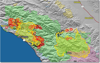
Crews on the Basin Complex near Big Sur are constructing indirect firelines up to 6 miles out ahead of the fire, using some of the same tactics that were successful on the nearby Indians fire, indirect line and then burning the fuels between the line and the main fire.

On the south side, dozers and hot shot crews are constructing and firing out a line from the North Coast Ridge Trail, south to the coast near Big Black Rock south of Esalen.

The fire on the north side is burning around Big Sur, while crews, dozers, and engines are working on containment lines that are mostly indirect, and are firing out behind houses as needed.

The map below shows heat, in red, orange, and black, detected by satellites last night, with the red areas being the most recently burned. The yellow lines are the perimeters uploaded by the incident management teams. Click on the map to see a larger version.

California: Piute fire

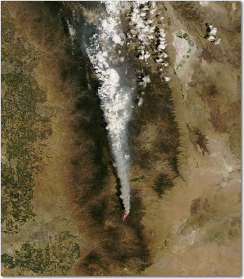
The Piute fire, about 6 miles south of Lake Isabella, was very active again yesterday, growing by 4,840 acres. This fire has a lot of potential to be a problem. It is now 7,040 acres and 6% contained.

South Zone reported this at 1800 yesterday:

The West side of the fire is unsafe for direct attack. The north end of the fire is running towards numerous camping areas and the communities and structures in Lake Isabella, Bodfish, Liebel Ranch, Valley View Sub-division, French Meadow, Historic Rocky Point Mining area, Red Mountain, and Claraville. Road closures were initiated today.

The map below shows heat in red and black detected by satellites last night, with the red areas being the most recently burned. Click on the map to see a larger version.

California: Piute fire

The Piute fire on the Sequoia NF started yesterday and is moving out. HERE is a link to an almost-live web cam view of the fire.

Piute (CA-SQF-1356) 2,560 acres and 4% contained. Protection of the USFS Repeater Site, the Buston Mill, historic town sites and critical habitat areas are a priority. Closure was ordered for area campgrounds, resulting in the evacuation of campers. Road closures include Piute Mountain Rd., Saddle springs Rd. and Cold Springs Rd. Evacuations were put in place for residences and visitors in Brown’s Meadow and French Meadow. An evacuation advisory notice was issued to residents and visitors of the Claraville Town site. An Evacuation Center was opened in Lake Isabella at the VFW/Senior Citizens’s Center.

Evacuation definitions

Posted on Categories Uncategorized

The Basin and Indians fires in Monterey County in California have caused various types of evacuations. Here are the definitions that the county is using:

1. Evacuation Advisory: This is a precautionary notice designed to give residents time to prepare for a possible evacuation. If you have special needs you might want to leave the area until the threat is passed. If you have livestock that needs transporting, you should move them.

2. Voluntary Evacuation: You are strongly urged to leave the area. If you choose to remain, you should be prepared to take action immediately if the danger approaches.

3. Mandatory Evacuation: You are in jeopardy and should leave the area immediately. If you choose to remain, you may be on your own as emergency personnel likely will not be able to help you.

California: Basin fire update

Posted on Categories Uncategorized

The Basin fire near Big Sur has been very active today and spread significantly on the northwest side closest to Big Sur as well as on the east side, moving closer to the Indians fire.

A local news article:

The Monterey County Herald
Article Last Updated: 06/29/2008 04:06:28 PM PDT

An evacuation advisory has been issued for the Palo Colorado Canyon area due to the northward spread of the Basin Complex fire Sunday.

The advisory is a precautionary notice warning residents to prepare to leave if necessary.

Basin Fire spokeswoman Tina Rose said Sunday that residents have been moving animals out of the area and many have made arrangements to stay elsewhere. More than 1,000 homes are threatened by the fire, which grew by more than 2,000 acres overnight.

“Most people are taking the advisory as seriously as we want them to,” Rose said. “The movement of the fire is to the north, east and south.”

Emergency broadcast announcements were aired on local radio and television stations Sunday morning.

The affected area includes Garrapatos Road, Redwood Estates, Green Ridge, Rocky Creek Ranch, Long Ridge, Rocky Creek Road and Ray Ridge Road.

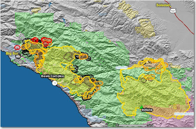
This map shows that the Basin fire is quite a bit closer to Big Sur than it was two days ago. Most of the heat shown on the Indians fire is from their burnout along the Arroyo Seco drainage.

The map below shows heat in red, orange, and black, detected by satellites, with the red areas being the most recently burned. The yellow lines are the perimeters uploaded by the incident management teams. Click on the map to see a larger version.