In light of the San Diego County Board of Supervisors making a recommendation that CalFire and the U.S. Forest Service have helicopters operate at night, what what do you think? Express yourself in the poll on the left side.
Category: Uncategorized
CA: Indians fire, more information
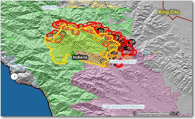
Here is the latest map of the Indians fire on the Los Padres National Forest in southern California which shows heat (in red) detected by satellites last night. Quite a bit of the heat is outside the last perimeter (in yellow) that was uploaded by the incident management team about 24 hours ago.
Some of the heat could be from burnout operations, but as we reported previously, additional structures were lost yesterday as a result of strong north winds which caused extreme fire behavior on the southeast side. The size is now reported to be 41,689 acres. For “Projected Movement”, the team says:
Primary spread of the fire will continue to the south and southeast.
CA: Indians fire update
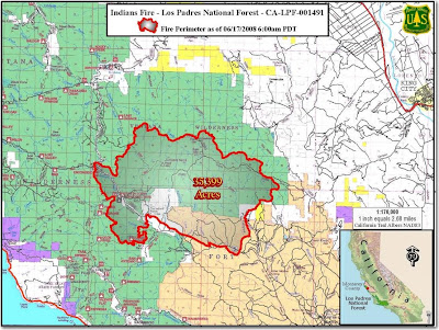
The Indians fire on the Los Padres National Forest in California this afternoon, Tuesday, destroyed more structures, including 1 residence, 3 second homes, 10 outbuildings and a motorhome. Several other structures in the area were saved by some of the 2,200 firefighters working on the incident which started from a campfire on June 8 and is now 35,339 acres. The containment percentage today decreased from 46% to 35% due to extreme fire behavior on the southeast side.
The map below shows the perimeter as of 0600 on June 17. Click on it to see a larger version.
Night air ops in San Diego County?
Some politicians still believe that if there had been another hour or two of daylight left when the 2003 Cedar Fire started, which burned 273,000 acres in San Diego county, it could have been stopped with a few bucket drops from the medium helicopter that was in the area. The truth is, that fire was pushed by very strong Santa Ana winds and it was off to the races in minutes. No aircraft could have stopped that fire in those conditions. No aircraft.
Air drops are worthless if there are no ground forces nearby to take advantage of them and put in hose lays or hand line. When the Cedar fire started it was much too dangerous for ground forces to directly attack the fire under the extreme conditions created by the strong winds, the vegetation, and the terrain. And if the wind is blowing the water or retardant sideways, it’s a waste of time and money, as well as being dangerous for the pilots.
But these facts have not stopped the San Diego County Board of Supervisors from pushing for night flying capability for firefighting aircraft. Supervisor Pam Slater-Price called night flying by water-dropping aircraft
“…a must-have” for the county. “We can’t afford to have out-of-date bureaucratic rules compromise public safety,” Slater-Price said. “I’m tired of excuses as to why it can’t be done.”
The Board of Supervisors is sending a letter to the State of California and the U.S. Forest Service asking them to begin negotiating rules that will allow for nighttime aerial firefighting in their jurisdictions.
Humbolt fire looters
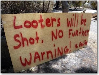
 Ray Dalton, the former mayor of Paradise, California, put up this sign.
Wildfire today covered the Humbolt fire earlier HERE; it burned 74 homes and 23,000 acres. Many of the homes destroyed were in the town of Paradise. Dalton put up the sign after he was told by police about residential burglaries during the evacuations. His home was spared by the fire, unlike many of those around him, but he plans to keep up the sign as a reminder to the gawkers cruising through the neighborhood.
Jay Grivette’s home was one of those burglarized. He is thankful that he had installed a security system that records video of the property which captured images of a white male entering the home. Police later arrested Jose Antonio Hernandez, 20, and charged him with burglary and looting. Evidence was also recovered at Hernandez’s residence.
 A photo taken with an infrared camera by Grivette’s security system shows the intruder who broke into his residence.
It’s a shame that Grivette’s home was burglarized, but at least it appears that the scum that broke into his house will be brought to justice.
Photos courtesy of ChicoER.com
NC: Evans Road fire update
The Evans Road fire in eastern North Carolina is going to be with us until a hurricane-style rain event occurs. It takes a lot of water to penetrate into several feet of peat. The size of the fire is being reported as 41,060 acres. The firefighters are still pumping huge quantities of water from nearby lakes onto the fire–19,000 gallons per minute.
In addition to Hendricks Type 2 Incident Management Team, there are two National Incident Management Organization teams on the fire, Custer’s and Whitney’s. There are 476 people working on the fire and it is 40% contained.
Below is a map showing the fire perimeter in yellow–and in red, orange, and black, the heat detected by satellites last night. I have not seen any evidence of the massive burnout operation the fire spokesperson mentioned last week that was going to occur on the east side along highway 94. Click on the map and photo to see larger versions.

The picture below shows a burnout operation on Seagoing Road.
Photo courtesy of InciWeb.

