Probability of a wildfire, by date and location

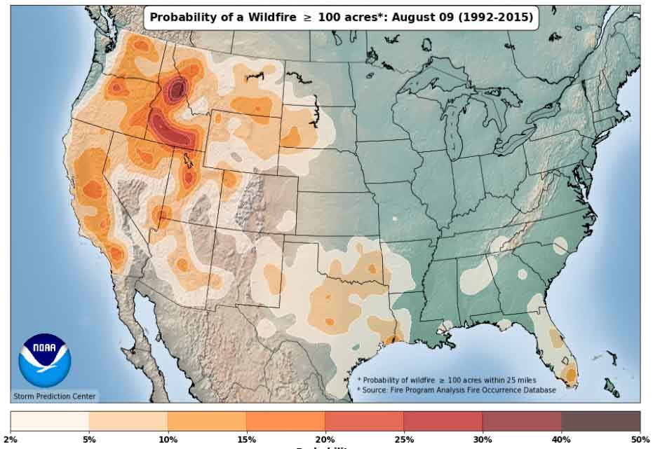
Above: Map showing the probability of a wildfire of at least 100 acres on January 12 between 1992 and 2015.

(Originally published at 10:40 a.m. MST January 9, 2018)

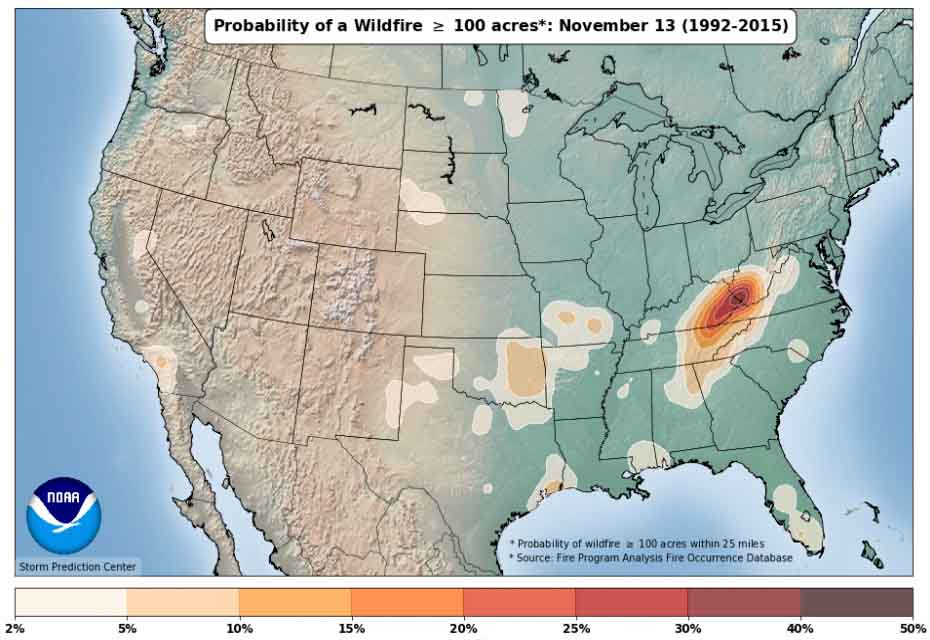
If you are searching for something to do on a cold winter day the National Weather Service has just what you need —  an interactive map system showing the probability of a wildfire of various sizes by date of the year. You can choose what size fire you’re interested in, 100, 300, 1,000, or 5,000 acres and allow the map to animate the entire year, or manually step through in three-day intervals. The data is based on wildfire occurrence between 1992 and 2015.

It is interesting seeing how activity builds and declines in specific areas like southeast Oklahoma, northern Minnesota, and the confluence of Kentucky, West Virginia, and North Carolina.

Thanks go out to Nick Nauslar of the NWS Storm Prediction Center for updating the maps.

Here are some examples:


wildfire occurrence 1992-2015 map
wildfire occurrence 1992-2015 mapwildfire occurrence 1992-2015 map

Report released on Thomas Fire Fatality

Above: A map from the report showing the entrapment location. The red line was the firefighter’s path of travel. It leads from the black circle, which was the site of the first spot fires, to a drainage.

(Originally published at 6:25 p.m. MST January 8, 2018)

CAL FIRE has released a “Green Sheet” preliminary report for the line of duty death of CAL FIRE Fire Apparatus Engineer Cory Iverson of the CAL FIRE San Diego/San Diego County Fire Authority. Engineer Iverson was overrun by fire and killed December 14, 2017 while battling the Thomas Fire in Ventura County north of Fillmore, California.

While working with a hose lay along a dozer line he was attempting to suppress a  spot fire across the fireline. As one spot fire became multiple spot fires he attempted to escape but was not successful.

The entire 2.6MB report is here. The portion of the document that describes the entrapment is below. Fire Apparatus Engineer Iverson is “FAE1” in the report.


…FAE1 responded on the assigned tactical frequency, that he saw the spot fire. He engaged the spot fire that was on the edge of the dozer line with his hand tool.

Immediately after the report of the spot fire, a second spot fire was reported approximately 20 feet into the green.

At some point, before leaving the dozer line, FAE1 dropped a 100 foot length of hose from his hose pack on the dozer line. This action left 200 feet of hose still in his hose pack.

As FAE1 reached the second spot and began to take action, it erupted. At the same time, additional spot fires erupted along the dozer line west of the original spot fire. FF1 sprayed in the direction of the spot fires. The spot fires rapidly increased in size and the hose stream was ineffective. FAE1’s escape route back to dozer line was cut off. FAE1 began traveling southwest, paralleling the dozer line. Due to fire intensity, FAE1 turned and headed down slope to the south. FAE1 made a request, on the assigned tactical frequency, for immediate air support. This was the last confirmed radio transmission by FAE1. STL1 contacted HLCO for immediate air support. HLCO responded, he had additional copters coming in and they too would begin to work the area.

At approximately 9:25 AM, FC1 reported to FAE1 on the assigned tactical frequency, additional spots were below him and he told FAE1 to “Get out of there.”

The fire intensity increased in the green along the dozer line. FF1 and FF4 retreated along the dozer line, while FF2 and FF3 retreated along the dozer line and then up into the black, towards the mid-slope road. All four FF’s dropped their hose packs on the dozer line while retreating.

At approximately 9:27 AM, FC1 declared, on the assigned tactical frequency, “Mayday, we’ve got a firefighter down.” FC1 then clarified, “We have a firefighter trapped.” STL1 confirmed with DIVS X he copied the “Mayday” of a firefighter trapped. DIVS X acknowledged the traffic with STL1 and requested, through Thomas Communications, an ALS ambulance to the address of the staging area below the avocado orchard.

At 9:28 AM, the response from Ventura County Fire Station 27 was started.

Copter 1, and two CWN copters, continued working the area below the dozer line attempting to provide an escape route for FAE1. These copters saw FAE1 retreating down through the green.

At that time, two spots erupted down slope and south of FAE1, in his path, causing him to turn southwest and start down slope toward the eventual entrapment site.

FC1 saw FAE1 fall and lost sight of him. Copter 1 also saw FAE1 fall, but get back up and continue down slope toward the eventual entrapment site.

It was described by those who saw FAE1 moving through the vegetation that the height was chest to head high; and in some cases, all that could be seen was the top of his helmet.

Prior to the fire, the vegetation height and thickness masked the view of the deep gulch in the drainage, which was the location of the eventual entrapment site.

STL1 contacted HLCO, re-confirmed a firefighter was trapped, and was told by HLCO, six helicopters were enroute.

The additional CWN copters arrived and each copter began working the area where FAE1 was last seen. Those copters dropped retardant at first, and then switched to water due to a faster turnaround time.


Thanks and a tip of the hat go out to Tom.
Typos or errors, report them HERE.

Evacuations ordered below wildfires in Santa Barbara County

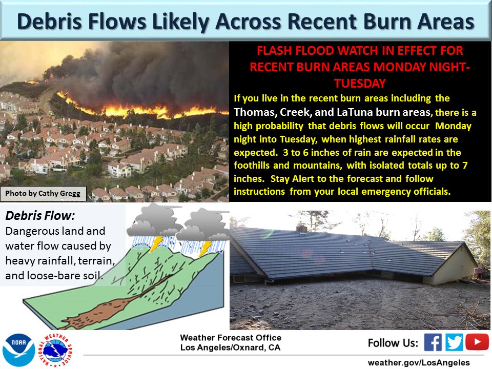
Very heavy rain could produce flash floods, mudslides, and life-threatening debris flows

(UPDATED at 12:22 PST January 9, 2018)

****

(UPDATED at 1:24 p.m. PST January 8, 2018)

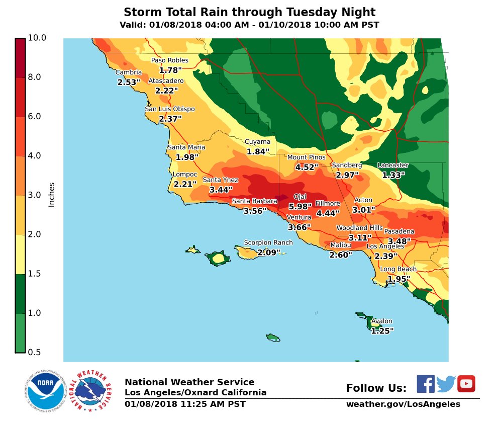
Some of the same residents who were forced to evacuate during this year’s wildfires in Southern California are being ordered to evacuate again as a very dangerous storm bears down on the area. Weather forecasters predict the Coast and valleys can expect 2 to 4″ with foothills and mountains seeing 4-7″ (locally up to 9″). Ojai, which is surrounded by the footprint of the Thomas Fire, is expected to receive 5.98″.

southern california storm total rain map

The fear is that flash floods, mudslides, and debris flows could be life threatening.

Santa Barbara County Emergency Management issued evacuation notices for areas below the Thomas, Whittier, Sherpa and Rey Fire burn areas beginning at 12 p.m. Monday, January 8. Residents can visit www.countyofsb.org and refer to the interactive map to determine if their property is affected by the notices, or call 211 or 800-400-1572 for more information.

Weather forecast for Santa Barbara
Weather forecast for Santa Barbara through Wednesday. NWS.

The very powerful storm moving into the area is resulting in not only predictions for heavy precipitation, but also strong winds. Various types of weather related warnings have been posted by the National Weather Service for the following counties: Ventura, Orange, San Luis Obispo, Santa Barbara, San Diego, Los Angeles, San Bernardino, Riverside, Monterey, and Kern. The Monday night forecast for Santa Barbara calls for 25 mph winds gusting to 38 mph out of the southwest and southeast.

warning debris flow wildfires

Jupiter, seen at 130,000 mph

Above: Photo of Jupiter taken by NASA’s Juno spacecraft. Processed by NASA/JPL-Caltech/SwRI/MSSS/Gerald Eichstädt/Seán Doran.

While NASA’s Juno spacecraft is orbiting Jupiter at 130,000 mph, it takes photos every 53 days that are unlike anything I have ever seen. They are beautiful.

This last batch released by NASA was taken during the craft’s 10th close pass over the planet December 16.

Since the distance between Jupiter and Earth is about half a trillion miles (562,382,633 miles today, but it varies) it takes a long time, days or weeks, to transmit the photos  back to Earth.

Jupiter photo NASA Juno
Jupiter, photographed by NASA’s Juno spacecraft. Processed by NASA/JPL-Caltech/SwRI/MSSS/Gerald Eichstädt/Seán Doran
Jupiter photo NASA Juno
Jupiter, photographed by NASA’s Juno spacecraft. Processed by NASA/JPL-Caltech/SwRI/MSSS/Seán Doran

Field tests of tracking devices for firefighters

We have often advocated the Holy Grail of Wildland Firefighting, which is knowing the real time location of firefighters and the fire.

There are many different technologies and platforms for collecting and displaying data about the location of the fire, but the information collected has yet to become commonplace in the hands fireline supervisors on the ground.

A similar situation exists for tracking the location of firefighting resources — personnel and equipment. The technology has existed for years, but the “deciders” in the National and State capitals have not recognized its importance for providing situational awareness, so it is only being used in a few scattered areas.

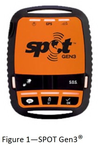
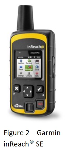
The Colorado Center of Excellence for Advanced Technology Aerial Firefighting (yes, they are still using that name) recently evaluated and tested two consumer-level personal tracking devices, the SPOT Gen3® and the Garmin inReach® (formerly known as the DeLorme inReach).

The executive summary from their report is below. The full document can be downloaded HERE.


Executive Summary
Wildland firefighters frequently operate in remote areas and are often a significant distance away from their supervisors or other nearby units. Additionally, wildland firefighters typically communicate with voice radios operating in analog mode, which does not facilitate location tracking or other digital situational awareness. One technology proposed to overcome these limitations and provide GPS location tracking and messaging for firefighters is satellite messengers. The Center of Excellence for Advanced Technology Aerial Firefighting (CoE) was requested to conduct a study of these devices to analyze their utility for firefighters. This study illustrated the technical specifications of two consumer-grade satellite messengers, the SPOT Gen3® and the Garmin inReach® (formerly known as the DeLorme inReach), and provided information on service options and costs. The study also assessed the capabilities of the SOS feature common to both devices and employed field trials to evaluate the performance of the devices in various types of vegetation and terrain.

SPOT Gen3The CoE found that the SPOT device provides a one-way flow of information from the device user to others using predesignated email addresses, text messages, or website access. This device requires programming ahead of use to designate the time interval for location tracking, as well as the content of the three types of messages it can send. The inReach device provides a two-way flow of information, with others able to communicate with the device user via email, text message, or website.

The SPOT device successfully transmitted a test SOS message from a meadow with a clear view of the sky, which then led to the Colorado Division of Fire Prevention and Control Duty Officer being notified of the SOS within 3 minutes. The SOS testing scenario was on a prescribed pile burn under the control of the area interagency fire management unit and the plan was for the Duty Officer to contact the interagency dispatch center regarding the SOS and have them establish radio contact with the unit in distress. Unfortunately, the phone system at the dispatch center was down during the test and no notification could be made. The CoE recommends that for mission-critical applications like wildland fire, the SOS feature be tied directly into relevant computer-aided dispatch systems—a complex requirement for interagency centers that frequently host firefighters from off-unit and from a variety of agencies.

Garmin inReachTo determine the utility of the satellite messengers for personnel tracking, six field trials were conducted—two each in minimal, moderate, and heavy forest canopy. For each level of canopy, one test was conducted in rolling terrain and one in rugged terrain. These tests sought to establish the rate at which the location of a firefighter walking the perimeter of a simulated 100-acre fire with both devices set on a 5-minute tracking interval would be known to a supervisor watching in real-time via an Internet connection.

The CoE determined that both devices can transmit location information successfully with minimal delays when used under minimal and moderate forest canopies. However, under a heavy forest canopy the devices experienced difficulties. The SPOT device failed to transmit 20% of points and the inReach device took more than 5 minutes to transmit 50% of points (and during one test, failed to transmit 35% of points). The CoE recommends shortening the tracking interval when operating under heavy forest canopies to increase the odds of successful transmissions and cautions against relying solely on these devices to achieve situational awareness for firefighters operating under heavy forest canopies.

Arizona Forest Service officer involved in shooting

(UPDATED at 11:22 p.m. MST January 8, 2018)

The FBI released more information Monday about the January 5 shooting in Arizona that left one person deceased:

A Forest Service Officer stopped to render assistance to a vehicular traffic accident. An altercation occurred between the officer and the subject, Tyler Miller of Kansas. It was later determined the officer was injured and treated on the scene by EMS personnel.  Miller was shot and transferred to a medical center and later declared deceased.

***

(UPDATED at 12:50 p.m. MST January 7, 2018)

According to KWCH, the person killed in the shooting that involved a U.S. Forest Service law enforcement officer January 5 has been identified as Tyler Miller. The uninjured USFS officer has not been named.

The FBI says 51-year-old Tyler Miller was injured and later died at a hospital. The officer’s name was not released, he suffered no injuries.

According to the office of the Kansas Secretary of State, Miller is the owner of TNT Bonding in Hutchinson [Kansas]. The family’s attorney, Matt Bretz, says Miller is a well-respected entrepreneur from Hutchinson.

The FBI says Miller was involved in a wreck earlier that evening.

***

(Originally published at 8:14 a.m. MST January 6, 2018)

A U.S. Forest Service law enforcement officer was involved in a shooting Friday January 5 north of Sedona, Arizona. According to local media the officer was not injured but one person was transported and pronounced dead at a hospital.

State Route 89A was closed for about five hours as the FBI investigated the incident.

On December 11 a wildland firefighter for the U.S. Forest Service was shot while driving a vehicle in Monterey County, California. The victim, Division Chief Peter Harris, was shot in the neck and ear. The suspect, Jacob Kirkendall, fled but was found and arrested.

In 2012 National Park Service Ranger, Margaret Anderson, was shot and killed in Mount Rainier National Park in Washington state.

Thanks and a tip of the hat go out to Tom.
Typos or errors, report them HERE.