California fire chief among those who lost home in wine country wildfires

(Originally published at 6:49 a.m. PDT October 11, 2017)

(Above: Mill Valley Fire Chief Tom Welch, a resident of Santa Rosa, has lost his family home due to the wildfires burning this week in Northern California). 

A fire chief in Northern California who has been coordinating his staff’s response to wildfires this week is among those whose family home has been destroyed.

Tom Welch is the fire chief of the 35-member Mill Valley Fire Department in Marin County. Though the city of 15,000 has generally been spared the destructive effects of the wine country wildfires, Welch and his family reside 40 miles to the north in Santa Rosa — among the hardest hit communities.

His home was among the estimated 2,000 structures that were completely destroyed by this week’s fires that erupted Sunday night, the city confirmed on its website.

The city in a statement said:

“His family is safe. At this point we are still learning how other City of Mill Valley employees are impacted as well. Our thoughts are with everyone who has been impacted by this disaster.”

An online fundraiser has been established to help Chief Welch and other families. By 6 a.m. PDT Wednesday, more than 450 donors had contributed $62,000 to the campaign.

Reports are beginning to circulate of other first responders whose homes were damaged or destroyed, though it remains unclear how many could have been affected.

At least 17 people have been killed and more than 2,000 homes destroyed in the series of more than a dozen fires that started late Sunday and early Monday across Northern California. Containment efforts are progressing for some fires, which have burned in excess of 100,000 acres, and conditions have calmed considerably from Monday morning’s ferocious winds.

That could change later this week as winds and red flag warnings return to the area.

“It’s devastating,” said Rep. Mike Thompson, D-St. Helena, who toured the fire-scarred region by helicopter, according to the San Francisco Chronicle. “I fully expect this will be the worst fire disaster in California history.”

Canyon 2 Fire burns 7,500 acres in Southern California

(Originally published at 7:36 a.m. PDT October 10, 2017)

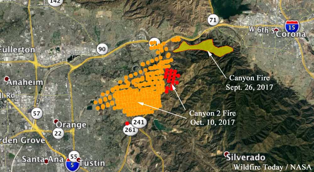
Canyon Fire map
The red dots represent heat detected on the Canyon 2 Fire by a satellite at 2:54 a.m. October 10. The yellow dots were detected at 12:54 p.m. October 9. The Canyon Fire started September 25, and the spread was stopped a few days later. Click to enlarge.

With attention — and resources — focused on the explosive growth and sheer scale of wildfires burning through Northern California’s wine country this week, crews to the south on Monday were busy battling an erratic, destructive and wind-whipped fire of their own.

The Canyon 2 Fire started Monday morning in the Anaheim Hills area.

By Tuesday morning, Anaheim Fire & Rescue reported the blaze to be at 7,500 acres. About 1,100 firefighters were assigned to the incident, with 14 helicopters and six planes assisting from the air.

It was just 5 percent contained.

The evacuation zone was primarily for residences in the wildland-urban interface south of the 91 Freeway and east of the 241.

Mandatory evacuations remained in place Tuesday. Some 24 structures are believed to have been destroyed, but exact details remain somewhat unclear.

Shifting winds were top of mind for crews on Tuesday.

Of note, the coastal marine layer that typically brings with it low-lying clouds and higher humidities was apparent Tuesday morning. However, the boundary line was pronounced, and the area of the Canyon 2 Fire was still experiencing single-digit relative humidity levels, courtesy of the Santa Ana Winds.

The Canyon 2 Fire was among several wildfires that blew up Monday in California, fed by high winds, low humidity and an abundance of fuels. Resources across the state were taxed as some fires went from ignition to tens of thousands of acres in just a few hours.

By Tuesday, “we’re gonna be as stretched as we can be,” said Steven Beech, an incident commander with the California Department of Forestry and Fire Protection, according to the LA Times. 

The area is only a few miles from Disneyland. Suffice to say photos from the so-called “Happiest Place on Earth” were a little more striking on Monday.

80,000 acres in 18 hours: Damage from historic California wine country wildfires comes into focus

(Originally published at 8:33 p.m. PDT October 9, 2017)

(Above: Map showing the location of the wildfires in Northern California. The red dots represent heat detected by a satellite at 12:54 p.m. PDT October 9, 2017. The yellow dots were detected in the previous 24 hours. Map compiled by Wildfire Today)

Monday marked the latest chapter in a book of unforgettable Octobers for California residents and firefighters alike, right next to the especially devastating fall months in 2003 and 2007.

The region was different this time — wine country of Northern California as opposed to the chaparral-dotted hillsides straddling the U.S-Mexico border near San Diego that bore witness to the Cedar and Witch fires, among the state’s most costly and destructive wildfires.

Throughout Monday, the similarities were coming into focus nonetheless.

Fanned by winds gusting in excess of 50 mph, upward of a dozen wildfires erupted Sunday night in the hills north of San Francisco and west of Sacramento. Already under a red flag warning, thousands of residents who went to bed Sunday gearing up for another week instead woke in the middle of the night and raced through ember-filled streets in a desperate effort to escape.

By morning, the scale of the fires was yet to be seen.

Hour by hour, the scope of the disaster came into focus.

By evening, the numbers were striking. In less than 24 hours, 15 wind-whipped fires in nine counties ignited and blackened more than 73,000 acres in less than 24 hours, according to CAL FIRE.

Among the three largest fires, based on CAL FIRE’s afternoon update: 

  • Atlas Fire in Napa County: 25,000 acres
  • Tubbs Fire in Napa County: 25,000 acres
  • Redwood Complex (Redwood and Potter fires) in Mendocino County: 19,000 acres

Several other fires ranging in size from a few acres to thousands also burned out of control into Monday evening.

More than 2,000 homes were destroyed, according to the governor’s office, and at least 10 people were killed with many more reportedly having suffered injuries. Many more were reported missing, and the death toll will almost certainly rise as operations transition to search and recovery.

Many of the fires remained 0 percent contained, despite the efforts of hundreds of firefighters from crews across the state.

A 747 Supertanker was among those resources assisting teams on the ground. By 6 p.m. PDT on Monday the aircraft had conducted six sorties, dropping over 110,000 gallons of retardant mostly in the Napa area. Many other air tankers and helicopters were also very busy slowing down the fires, where possible, with water and retardant.

A clearer picture of the damage is expected in coming days. But those visuals thus far, of lush vinyards and go-to wineries leveled, mobile home parks and up-scale neighborhoods both decimated, and even more damage expected as a red flag warning lingers into Tuesday.

Gov. Jerry Brown on Monday declared a state of emergency for several affected counties and also requested a Presidential Major Disaster Declaration to support state and local responses on the heels of an emergency proclamation issued for Napa, Sonoma and Yuba counties.

Mr. Brown’s major disaster declaration request in part:

“These fires have forced thousands of Northern California residents to immediately evacuate their homes and seek temporary shelter in order to save their lives. Many residents had little time to flee due to the fires’ rapid and erratic rate of spread through the rural terrain. Tragically, these fires have already taken lives and emergency responders anticipate the number of fatalities could grow.

The devastation and disruption caused by these fires is extraordinary. Thousands have been made homeless. Many school remain closed. Major roads were damaged or destroyed. The fire destroyed utility poles causing the loss of power to over 38,000 residents. These fires have destroyed and continue to threaten critical infrastructure, including 80 communication towers, impacting essential services for thousands of people…”


Fires in Southern California from years past were known for their fast, yet steady, rate of growth over the span of several days — perhaps the biggest distinction between this week’s fires to the north that exploded overnight.

Still, there’s the potential for even greater growth and destruction through the week. Winds are forecast to ease on Tuesday morning, but dry conditions will continue with highs in the mid-to-upper 70s and 80s by the weekend, according to the National Weather Service. 

Wildfires erupt overnight in California’s wine country

(Originally published at 7:57 a.m. PDT October 9, 2017)

(The Tubbs Fire burns in Northern California Monday, Oct. 9, 2017, as seen from this video posted on YouTube by Craig Philpott)

A series of fires fanned by high winds erupted Sunday night and Monday morning in California’s wine country, charring at least 20,000 acres and sending thousands of people fleeing homes, hotels and hospitals in the middle of the night.

The fires, many of which started late Sunday, burned out of control across hillsides in Sonoma and Napa counties, north of San Francisco and west of Sacramento. Multiple other counties were affected as smoke pushed into neighborhoods as day broke.

The largest, the Tubbs Fire, scorched in excess of 20,000 acres within just a few hours, Santa Rosa Fire reported. The fast-moving fire forced the evacuation of area hospitals, closed schools and led officials to recall all city employees to help staff the emergency operations center.

The Santa Rosa city manager and acting director of emergency services declared the situation a local emergency, according to the incident’s information page. 

“This is a life-threatening event,” the Santa Rosa Police Department said in a 2 a.m. alert regarding the evacuations. “Leave immediately.”

There was no immediate word on injuries to civilians or first responders.

The National Weather Services has issued a Red flag warning for the region until 5 a.m. Tuesday. North winds were forecast to gust to 30 mph through the day Monday before shifting to the south and diminishing by afternoon.

“Warm temperatures, low humidity and locally strong winds will coincide with critically dry fuels,” forecasters warned.

Red flag warnings were in effect across Northern California on Monday.

The nearby Marin County Sheriff’s Office reported no fires Monday morning but said its 911 dispatchers were overwhelmed with people calling to report smoke from other area fires being pushed into their neighborhoods.

Video from residents in the area shows the frantic evacuation efforts that unfolded Monday morning.

The exact magnitude of this event remains unclear as day breaks in the area. Photos circulating online, including several hosted here by The San Francisco Chronicle, show several structures, including homes, totally destroyed in the densely populated area.

Press conference with the cast of “Only the Brave”

Below we have a recording of the live press conference that occurred in Los Angeles Sunday morning October 8, 2017 featuring nine people associated with the movie about the Granite Mountain Hotshots, “Only the Brave”.

On June 30, 2013 19 members of the crew were killed on the Yarnell Hill Fire south of Prescott, Arizona. Of the 20 Hotshots, the only one that survived was Brendan McDonough. In the photo above, Brendan is on the left in the front row and was introduced as a creative consultant. One of the actors mentioned that he was on the set almost every day. Seated in the front row to Brendan’s left (L to R) are Miles Teller (he plays Brendan in the film), Josh Brolin (Eric Marsh), Jennifer Connelly (Amanda Marsh), and Jeff Bridges (Duane Steinbrink).

In the back row (L to R) are Joseph Kosinski (Director), Taylor Kitsch (Chris MacKenzie), James Badge Dale (Jesse Steed), and Pat McCarty (former Granite Mountain Hotshot, served as a consultant).

The press conference below starts at about 4:00.

The movie opens nationwide October 20, 2017.

Man killed during helicopter mulch operation at Brian Head Fire

Monday, Oct. 9 UPDATE: Officials identified the victim as 58-year-old Bryan Burr, of Alpine, Utah. The Salk Lake Tribune newspaper reported Burr was the brother-in-law of Sen. Mike Lee, R-Utah.

We have also learned he was the co-owner and president of a charter helicopter service. Visit FireAviation.com to learn more.

*****

Original story: A man was killed Saturday October 7 during Burned Area Emergency Response (BAER) operations on the Brian Head Fire in southwest Utah. The 58-year old crew member on the ground from Alpine, Utah was giving directions to a helicopter dropping straw mulch when he was struck on the head. The pilot saw the injured man and contacted others who called 911.

Brian Head Marshall Jeff Morgan was flown to the remote site off State Route 143 about 1:45 p.m. and determined that the man had died.

Brian Head Fire map
Map showing planned BAER treatments on the Brian Head Fire.

A statement from the Iron County Sheriff’s Office read:

It was determined he likely died as a result of blunt force trauma from falling debris during the airdrop.

It was not clear from the statement if the man was hit by straw mulch or debris from a nearby tree as the straw fell.

The identity of the person killed has not been released.

Since an aircraft was involved in the fatality the National Transportation Safety Board will be investigating the accident.

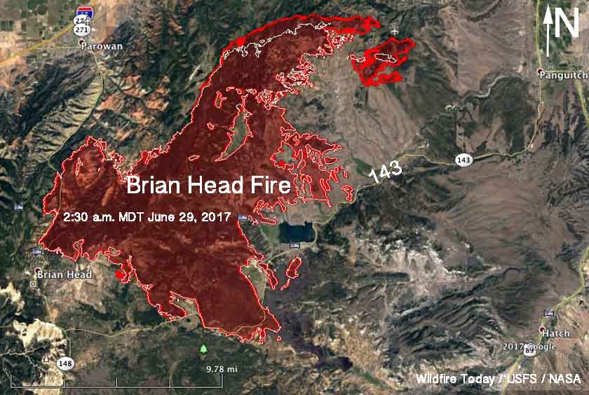
Map Brian Head Fire Utah
Map of the Brian Head Fire in southwest Utah. The red line was the perimeter at 2:30 a.m. MDT June 29, 2017. The white line was the perimeter 24 hours earlier.

The Brian Head Fire burned over 63,000 acres in late June.  On August 25 BAER teams began dropping 3,200 tons of wheat straw from helicopter nets to cover the soil surface. The additional ground cover increases the germination of seeds dropped earlier and helps absorb raindrop impact lessening water runoff potential.

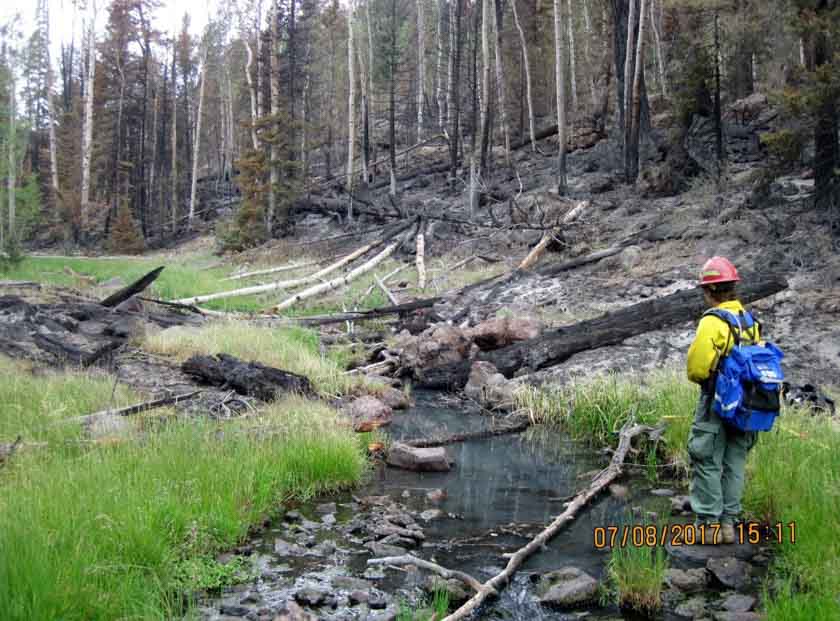
BAER treatments Brian Head Fire
File photo of a BAER team member on the Brian Head Fire, July 8, 2017. BAER team photo.

Our sincere condolences go out to the family, friends, and coworkers.
Thanks and a tip of the hat go out to Charlie.
Typos or errors, report them HERE.