Two wildfires in Washington were very active Tuesday

The Diamond Creek Fire burned across the international border into Canada Tuesday.

Above: Satellite photo showing smoke from fires in the Northwest United States August 29, 2017. The red dots represent heat detected at 3:56 a.m. PDT August 30, 2017.

(Originally published at 8:30 a.m. PDT August 30, 2017)

The Diamond Creek and Norse Peak Fires in Washington were very active Tuesday.

The Diamond Creek Fire in northern Washington that has been burning for five weeks spread across the border into Canada Tuesday. A spokesperson for the fire, Connie Mehmal, said it added another 16,000 acres to bring the size up to almost 49,000 acres, but heavy smoke on the north side in Canada prevented accurate mapping. The fire is not being completely suppressed, but special emphasis is directed toward protecting structures, including the community of Mazama on the south side.

Assigned to the fire are 3 helicopters and 3 fire engines for a total of 53 personnel, Ms. Mehmal said.

Diamond Creek Road
Firefighters on the Diamond Creek Fire chip debris along Ortell Creek Road, August 27, 2017.

The Norse Peak Fire on the north side of Highway 410 northeast of Mount Rainier National Park grew by more than 9,000 acres Tuesday and has now burned 12,904 acres. Most of the spread was on the north side, pushed by a strong wind out of the south. The fire behavior on Monday and Tuesday was described as “plume dominated” and “extreme running, group torching, and short-range spotting”.
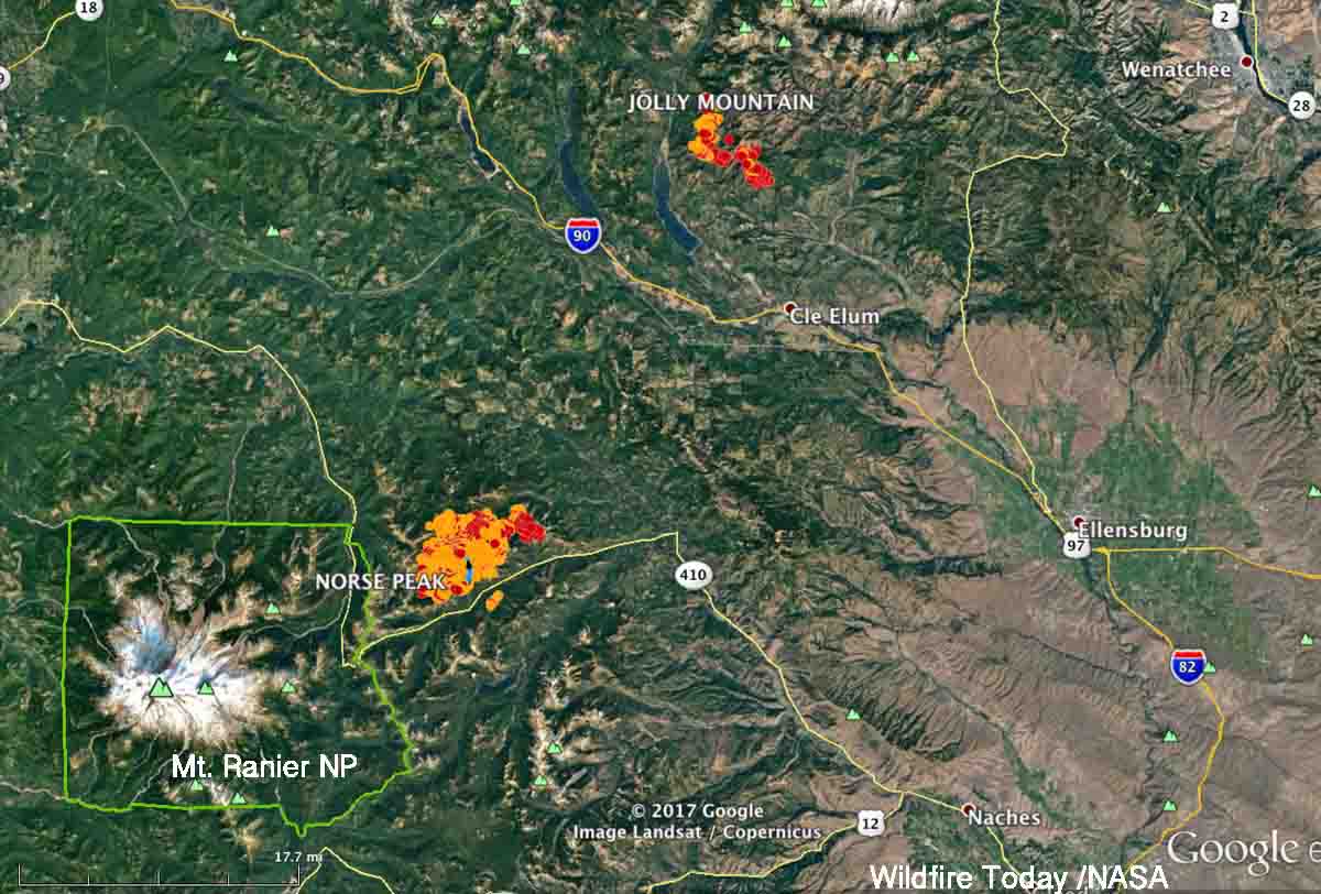
Norse Peak Jolly Mountain fires
Norse Peak and Jolly Mountain Fires, showing heat detected as late as 3:56 a.m. PDT August 30, 2017. The red areas are the most recent.

The strategy on the Norse Peak fire is not to completely suppress it, but to herd it around as necessary to protect private property and structures.

Rice Ridge Fire forces evacuations at Seeley Lake, Montana

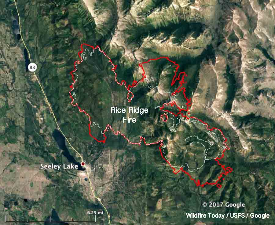
Above: A 3-D map of the Rice Ridge Fire, looking northeast. The red line was the perimeter at 10:30 p.m. MDT August 28, 2017. The white line was the perimeter two days earlier

(Originally published at 9:37 a.m. MDT August 29, 2017)

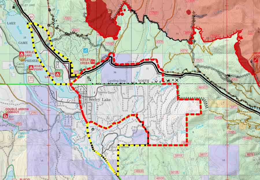
The Rice Ridge Fire made an unexpected southerly surge Monday evening toward the community of Seeley Lake after the wind direction shifted from the south and southwest to come out of the north and northwest. At about 7 p.m. Monday fire officials issued a mandatory evacuation order and three hours later expanded the area to include much of the community.

evacuation map rice ridge fire
Screen grab from a portion of the incident management team map of the Rice Ridge Fire dated August 29, 2017. The red dashed line is labeled “evacuation” while the yellow dashed line is “warning”. The solid red area was the fire at 10:30 p.m. MDT August 28. For the most current evacuation information go to Inciweb.

When the fire was mapped by a fixed wing aircraft at 10:30 p.m. Monday the Rice Ridge Fire had approached to within 1.5 miles of the Seeley Lake Community after a large finger of fire spread from the western flank. Sunday evening the incident management team had written in their evening update:

Containment is up to 22% as crews completed fire line along the west flank of the fire. Firefighters successfully completed small firing operations along the west and southwest edge of the fire that will aid in securing fire line.

The term “contain” or containment percentage means a fire line has been established along a portion of the perimeter. It does not mean the fire is “controlled” or “out”.  A 2-foot wide or 100-foot wide fireline is not guaranteed to stop the fire at that point. Strong winds have been known to blow burning embers and start new spot fires more than a mile away. The incident management team appears to be computing the containment percentage the way it should be done — showing the percentage of the fire perimeter where a fireline is completed and the spread is at least temporarily halted. The fire could continue to spread across the fireline, but it is not thought likely. The unexpected wind shift may have been the unlikely occurrence in this case.  The definition of these and hundreds of other fire management terms are in the National Wildfire Coordinating Group Glossary.

map rice ridge fire
Map of the Rice Ridge Fire. The red line was the perimeter at 10:30 p.m. MDT August 28, 2017. The white line was the perimeter two days earlier

An incursion into the air space over the fire by a drone shut down all firefighting aircraft Sunday evening.

Seeley Lake is closed so that firefighting aircraft can safely access the lake to refill their water buckets or tanks.

The incident management team is not releasing a great deal of information about the fire. It has been almost two weeks since photos were posted on their Inciweb page.

Engine crew’s escape route cut off by fire; takes refuge in burned area

An engine crew’s egress from their assignment while working on a spot fire on the Chetco Bar Fire in Southwest Oregon was cut off by the advancing edge of the main fire August 18, 2017 on the Rogue River-Siskiyou National Forest.

Below is the narrative from the 72-hour report issued August 26, 2017, which has preliminary information subject to change.

****

“On Friday, August 18, 2017, at approximately 12:30 pm, the Chetco Bar Fire cut off a Type 3 Wildland Fire Engine from the rest of their task force and from safe egress. Three firefighters in the engine drove through the fire to reach a safe location and spent the night within the active fire perimeter. They reunited with rest of their crew members early the following morning. There were no injuries or vehicle damage, but this incident had potential for very serious outcomes.

The engine was supporting a burnout operation on the south side of National Forest System Road 1917 to protect Packer’s Cabin, a historic building on the Rogue River-Siskiyou National Forest managed as a recreational rental cabin. The engine became separated from the rest of the task force when it engaged a spot fire on the north side of the road, supported by a Type 1 helicopter.

Preliminary indications are that the main fire pushed up from the drainage to the south and crossed Road 1917 west of the engine, cutting it off from egress and from the rest of the task force. After consulting with the helicopter and the Task Force Leader, the engine turned around and headed back east along Road 1917 to a wide spot mostly cleared of fuel by intense fire the previous night and that morning. They spent the rest of the day there before making their way back west to the cabin in the evening, where they spent the rest of the night. Night Shift was able to reach them early Saturday morning and lead them back out of the fire.

A Facilitated Learning Analysis (FLA) Team has been assigned, and is working with participants to identify lessons learned from this incident. The intent of the FLA is to share the story of the incident with others in the wildland fire community so that future responders can anticipate similar events and avoid injury or entrapment.”