Wildfire forces evacuation of Brian Head, Utah

Above: The Brian Head Fire at Brian Head, Utah. Photo by Iron County Sheriff’s Office, posted June 17, 2017.

The Brian Head Fire has burned at least one home in the town by the same name, which is 12 miles east of Cedar City, Utah. As of Saturday evening the fire had burned about 957 acres on the north side of the town near the Dixie National Forest. Multiple structures are threatened.

The fire was reported at 12:20 p.m. on June 17 and caused the evacuation of all 500 residents of the town.

A Type 3 Incident Management Team was due to arrive Saturday evening, and a Type 2 Team is expected at mid-day on Sunday.

Brian Head Fire 3-d map
A 3-D map showing the approximate location of the Brian Head Fire as of 4:30 a.m. MDT June 18, 2017.
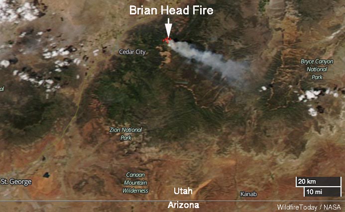
Brian Head Fire map
Satellite photo showing smoke from the Brian Head Fire June 17, 2017.

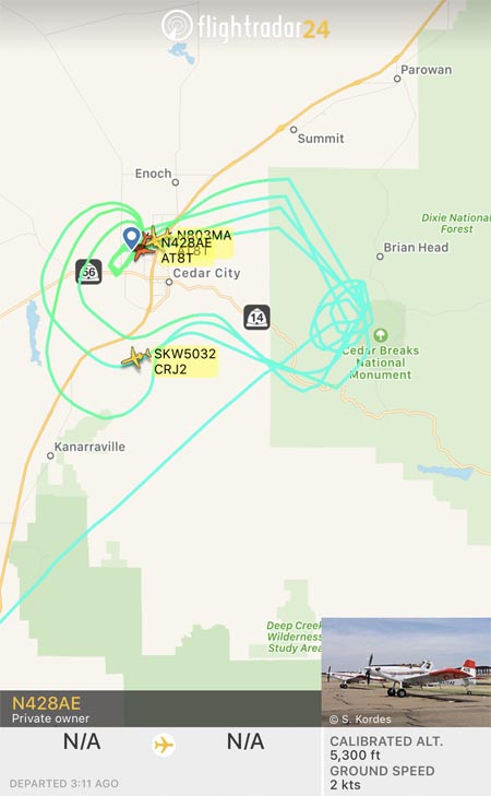
An inversion early Sunday morning trapped smoke, degrading visibility to the point where firefighting aircraft could not be used, but by noon MDT two Air Tractor 802A Single Engine Air Tankers were working the fire. They were reloading at Cedar City 12 miles away so they undoubtedly had short turnarounds in spite of the 4,000-foot climb from the air tanker base to the fire.
Brian Head Fire air tanker
Flight paths of a Single Engine Air Tanker working the Brian Head Fire at 12:50 p.m. MDT June 18, 2017.

The wind on Saturday was from the northwest, but on Sunday it shifted to come out of the north. As you can see in the image above, at about noon on Saturday the flight paths of one of the Single Engine Air Tankers were concentrated south of Brian Head, on the west side of Cedar Breaks National Monument.

The wind on Saturday is predicted to be out of the north at 8 to 10 mph with gusts to 13. The relative humidity should be in the mid-20’s and the temperature will be in the high 60’s. The coolish temperatures are due to the altitude — 8,000 to 10,000 feet above sea level in the fire area, which is about 4,000 feet higher than Cedar City.

The impressive video below posted by the Iron County Sheriff Office shows an air tanker dropping retardant apparently into heavy smoke. Perhaps there were structures or firefighters, or both, threatened in that area.

Satellite photo of wildfires in the Southwest

The image above from the Goes-16 satellite shows smoke from the large fires in Arizona and New Mexico on June 17, 2017.

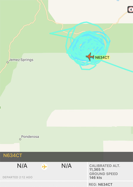
Below: in the two hours since it left the Santa Fe Municipal Airport, an Aero Commander air attack aircraft owned by “N9FX” has orbited the Cajete Fire west of Los Alamos, NM many, many times.Cajete Fire Air Attack Ship

Death toll rises to 62 in Portugal wildfire

Above: Photo by Euronews.

(Updated at (9:55 a.m. MDT June 18, 2017)

The number of people killed in the wildfire southeast of Coimbra, Portugal has risen to at least 62, according to the BBC. That number will probably increase as many remain missing and not all affected areas have been reached by authorities. Six firefighters have been seriously injured and two that were reported missing have been found with injuries.

Hundreds of firefighters and 300 pieces of fire apparatus are battling the fire southeast of Coimbra, one of 60 that broke out Saturday. Approximately 1,700 firefighters have been mobilized across Portugal during the recent extremely hot weather which brought temperatures over 100F. Dry thunderstorms are one of the possible causes of the fires. The government reports that 360 soldiers are assisting firefighters.

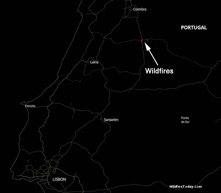
wildfires southeast of Coimbra, Portugal
Map showing the location of the wildfires southeast of Coimbra, Portugal.

Most of the fatalities occurred while residents were attempting to flee in their cars from the Pedrógão Grande area about 30 miles southeast of Coimbra.

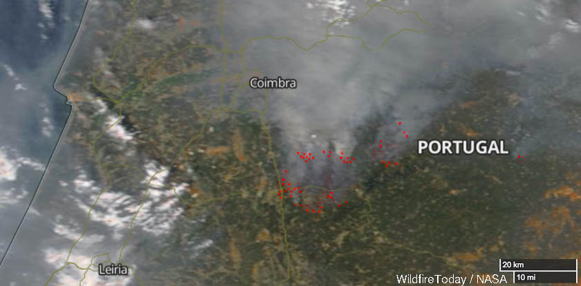
Wildfires southeast of Coimbra, Portugal
Wildfires southeast of Coimbra, Portugal.

The European Commission says it is working with EU member states to respond to the call for assistance issued overnight by Portuguese authorities. The Prime Minister of Greece, Alexis Tsipras, said “Greece will offer any help necessary to fight the fires.” Spain and France are both sending several firefighting aircraft.

Wildfires kill 25 in Portugal

(12:42 a.m. MDT June 18, 2017)

The BBC is reporting that 25 people have been killed in wildfires in central Portugal. Several firefighters are reported to be among about 20 people injured.

Most of the fatalities occurred while attempting to flee in their cars from the Pedrógão Grande area about 30 miles southeast of Coimbra.

From the BBC:

Secretary of State for the Interior Jorge Gomes earlier said that three people died from smoke inhalation and 16 died in their cars on the road linking Figueiró dos Vinhos to Castanheira de Pera.

About 60 forest fires broke out across the country overnight, with 1,700 firefighters working to put them out. The flames spread “with great violence” on four fronts, Mr Gomes said.

Spain has sent two water-bombing planes to help tackle the fires.

Portugal has been experiencing dry thunderstorms and temperatures well above 100F in recent days.

wildfires west of Pedrógão Grande in Portugal
Map showing the location of wildfires west of Pedrógão Grande in Portugal. Click to enlarge.

Lake Fire near Castaic Lake in Southern California

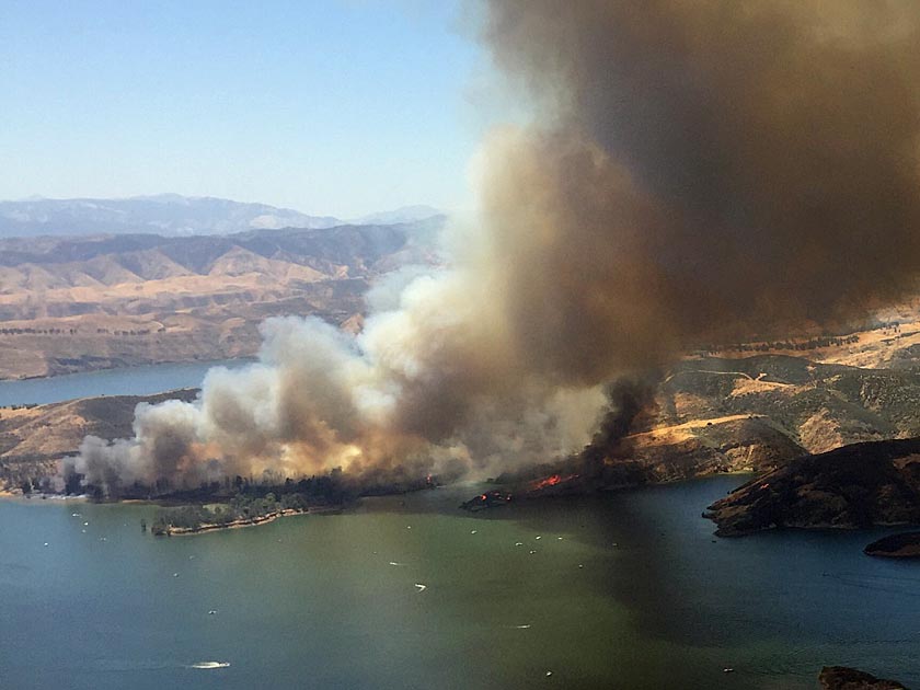
Above: the Lake Fire burns near a dozer line near Castaic Lake in Southern California. Screen grab from Los Angeles County Fire Department video.

(Originally published at 11:01 p.m. PDT June 17, 2017)

Firefighters in Southern California are battling a wildfire that started east of Interstate 5 near Castaic Lake north of Santa Clarita. As the sun was setting Saturday evening firefighters estimated that it had burned at least 1,000 acres, spreading from County land near the lake into the Angeles National Forest .

The fire was first reported at about 2 p.m. PDT on Saturday. Two small outbuildings were reportedly destroyed.

Some firefighters were transported across the lake in boats, according to the Angeles National Forest.

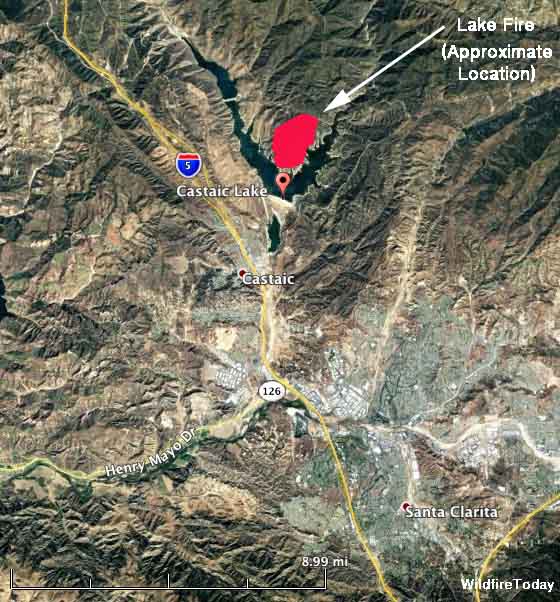
Lake Fire map
Map showing the approximate location of the Lake Fire north of Castaic Lake in Southern California, Jun e17, 2017.
Lake Fire, June 17, 2017. Los Angeles County FD photo.

Cajete Fire west of Los Alamos doubles in size

Above: A 3-D map of the Cajete Fire in northern New Mexico. The red line was the perimeter at 10 p.m. MDT June 16, 2017. The white line was from about 20 hours earlier. 

(UPDATED at 11:54 a.m. MDT June 17, 2017)

The Cajete Fire in the Santa Fe National Forest doubled in size on Friday, increasing to 1,325 acres. The fire has burned on both sides of Highway 4 in the Santa Fe National Forest 7 miles northeast of Jemez Springs and 12 miles west of Los Alamos in northern New Mexico.

The fire is spreading mostly through timber. Yesterday the southeast portion moved into the footprint of the Las Conchas Fire that burned 63 structures and 156,000 acres in 2011. It is likely that in the six-year old fire scar there will be less resistance to control.

Officials believe the fire started approximately one mile northeast of Vallecitos de los Indios but have not yet released a cause. The burned area runs along the East Fork of the Jemez River.

Approximately 70 structures are threatened, many of which have been evacuated, including a lookout tower.

On Friday the fire ran up a slope south of Highway 4, from 8,300 feet above sea level to about 9,300 feet.

On Friday the firefighting resources assigned included about 150 personnel, multiple engines, one bulldozer, four helicopters (including a rappel ship), five air tankers, and two air attack platforms.

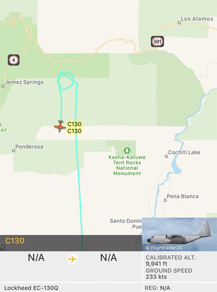
As this was written at 11:50 a.m. MDT on June 17, a C-130Q air tanker had just departed the fire after presumably dropping a load of fire retardant. See the map below.

C-130Q air tanker Cajete Fire
A C-130Q air tanker departs the Cajete Fire at 11:50 a.m. MDT June 17, 2017.

Mark von Tillow’s Type 1 Incident Management Team from California assumed command at 7 a.m. on Saturday, taking over from a Type 3 Team. The official strategy of the team is to fully suppress the fire.

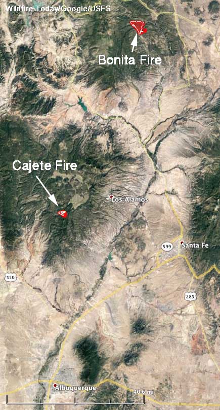
Map Bonita and Cajete Fires
Map showing the location of the Bonita and Cajete Fires north of Albuquerque, New Mexico.