BlueSky Modeling Framework

BlueSky screen grab
Screen grab from a BlueSky animation.

The U.S. Forest Service has developed a system called BlueSky Modeling Framework using multiple models that when combined in various configurations can enable:

  • the lookup of fuels information from fuel maps
  • the calculation of total and hourly fire consumption based on fuel loadings and weather information
  • the calculation of speciated emissions (such as CO2 or PM2.5) from a fire
  • the calculation of vertical plume profiles produced by a fire
  • the calculation of likely trajectories of smoke parcels given off by a fire
  • the calculation of downstream smoke concentrations.

The image above is a screen grab from a Beta website of an animation of a 3-hour running average of PM 2.5 using modeled fires. (Don’t ask me to explain it any further than that!)

More information about the system is HERE. You can configure your own animation at THIS SITE.

Washington state asks for volunteers to fight wildfires

Washington DNR volunteer signup

Illustrating the severity of the wildfires and the shortage of firefighters in the northwest, for the first time ever the state of Washington is asking for volunteers to help suppress the 12 uncontained large fires currently burning in the state. Five of those fires are “complexes” that are comprised of many fires, sometimes more than 10.

At first the Department of Natural Resources was asking for anyone who could operate heavy equipment, such as a dozer or grader, who would then be given specific wildfire training. But now the DNR is only accepting volunteer applications from:

…from those with wildland firefighting qualifications, including an Incident Qualification Card (commonly called a Red Card), a “Blue Card,” or a letter of certification from a local or rural firefighting agency stating that you have met appropriate physical fitness, experience and training standards for serving on wildfire incidents.

Please complete our online intake form by listing your qualifications and contact information to volunteer with our temporary community resource coordination centers in Colville, Omak and Castle Rock.

The DNR has set up centers at three locations to talk to potential volunteers:

Omak:  Jay Guthrie
Omak City Hall
2 Ash St. N
Phone 509-826-2546

Colville:  Julie Sacket
Washington State Department of Transportation
Second Floor
440 N Hwy 395
Phone 509-675-7847

Castle Rock: Kellie Williams
601 Bond Rd.
Castle Rock, WA 98611
Phone 360-575-5024

250 active wildfires in the United States

Posted on Categories Uncategorized
map wildfires northwest
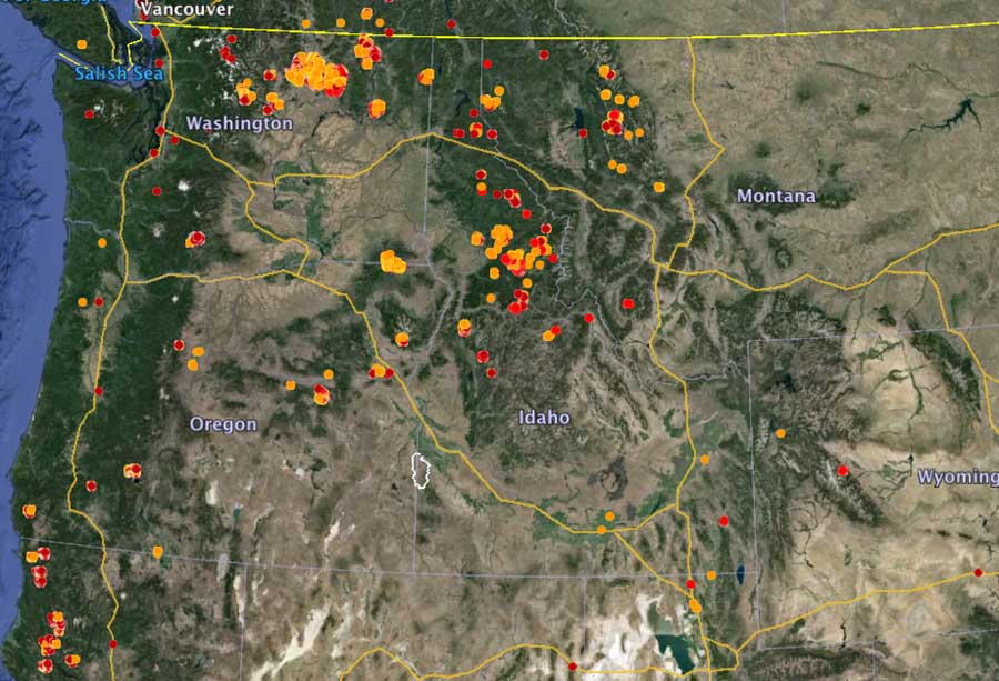
The map shows heat detected on wildfires by a satellite in the northwest U.S. during the 24-hour period ending at 9:12 a.m. PT, August 22, 2015. (click to enlarge)

The National Interagency Coordination Center’s Situation Report for Saturday includes 250 “active” wildfires in the United States, and 46 of those are large, uncontained fires. The number of hand crews assigned to fires, 680 now, continues to grow. There are 32,255 personnel committed to battling the fires.

At last count there were 46 incident management teams and 3 area command teams assigned or activated. The Situation Report only shows 2 area command teams assigned; one in northeast Washington and another in northwest California. But including one team on “NCF Fire Support/Preposition”, three have been activated. Earlier this year the number of area command teams was reduced from 4 to 3, which was a controversial decision.

A “fly-through” of the wildfires in north-central Washington

This video created by Kenji Kato using Google Earth, is a “fly-through” showing heat data collected by a satellite for the Chelan Complex of Fires, the Okanogan Complex of Fires, and other fires in north-central Washington state. The fly-through starts above the U.S., then flies in on the Pacific Northwest, then Central Washington, before closing in on the fire areas. The icons represent heat detected by a satellite as late as 3:30 a.m. PDT on August 20, 2015.

The icon color is based on fire activity with red representing heat detected in the last 0-12 hours (at the time data was updated). Orange represents activity in the previous 12 to 24 hours, and yellow is data 1 to 6 days before.

washi

Smoke from wildfires in Northwest affects western states

(UPDATED at 3:07 p.m. MT, August 22, 2015)

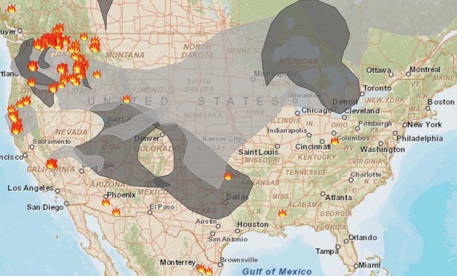
Air quality, smoke, wildfires 3 pm 8-22-2105

Above is an updated map, at 3 p.m. MT, August 22, 2015, showing the distribution of wildfire smoke across the U.S.

****

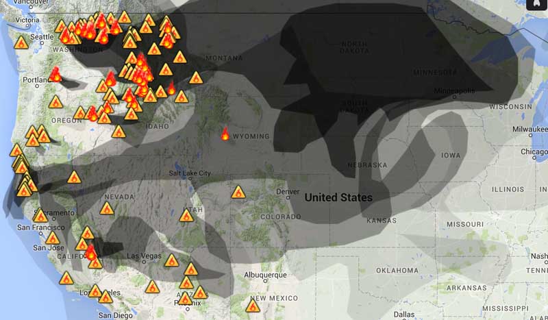
Map of wildfire Smoke
Smoke from wildfires, August 22, 2015. Weather Underground. (click to enlarge)

The wildfires in Washington, Oregon, Idaho, and Montana are creating a great deal of smoke that is seriously degrading the air quality hundreds of miles away.

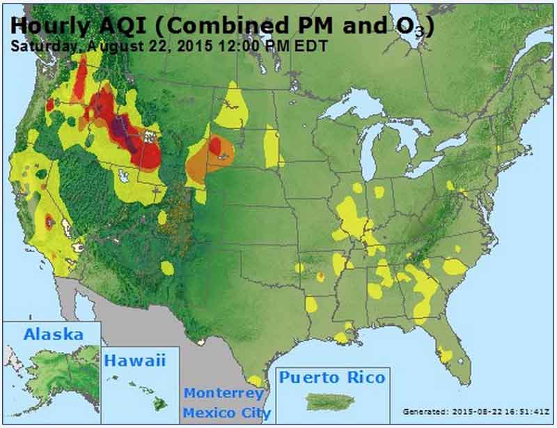
For example in southwest South Dakota, 800 miles away from the large fires in Washington, there is a very strong smell of forest fire smoke and the air quality measuring stations are recording an “unhealthy” air quality index.

Air quality noon EDT, Aug 22, 2015
Air Quality Index, at noon EDT, August 22, 2015. Airnow.gov (click to enlarge)
Air quality, wildfire smoke
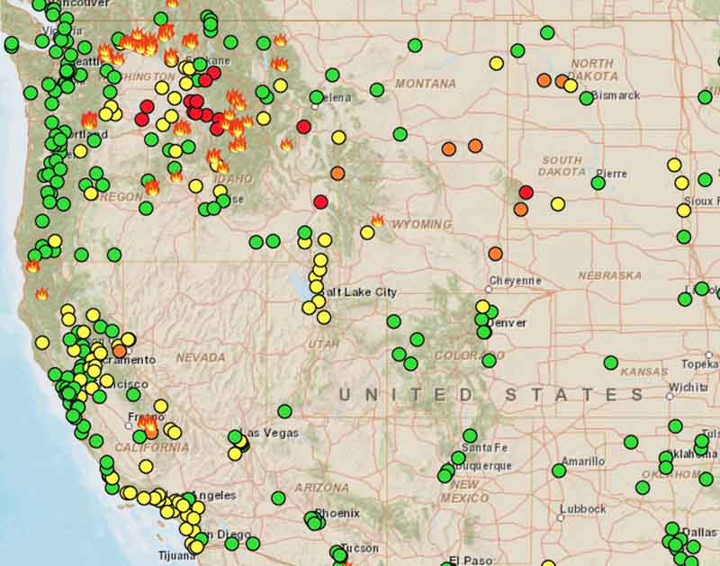
Readings from air quality stations at 8:26 a.m. MT, August 22, 2015. Some areas are affected by wildfire smoke.

To see the most current smoke reports on Wildfire Today, visit the articles tagged “smoke” at https://wildfiretoday.com/tag/smoke/

Firefighters killed in Twisp River Fire identified

The three U.S. Forest Service firefighters that were overrun by fire and killed on the Twisp River Fire in Washington August 19 have been identified as Tom Zbyszewki, 20, Andrew Zajac, 26 and Richard Wheeler, 31.

Their vehicle crashed while fighting a fire west of Twisp, Washington. Fox News reported “Authorities gave few details, shedding no light, for example, on the crash, other than to say that it was not the accident itself that killed the victims, but the fire.”

On Thursday, after a team of investigators assessed the accident site, the bodies of the three firefighters were removed in separate ambulances and transported from the scene in a procession of fire engines and other emergency vehicles.

Four other firefighters were injured, one very seriously. King5 had additional information about the serious injury:

Daniel Lyon, 25, of Puyallup [Washington], was airlifted to Harborview Wednesday in critical condition. Doctors say he suffered third degree burns to over 50 to 75 percent of his body.

Doctors said he was in the resuscitation phase, receiving a lot of fluids, and doctors were trying to stabilize his condition. If his condition improves, doctors hope to move him to the operation phase, where they will remove some of the burns from his body.

Lyon had only been a firefighter for a few months with the U.S. Forest Service before heading to Central Washington to battle the Okanogan Complex Fire.

Q13 reported that the other three injured firefighters were treated at a hospital and released.

The investigation into the accident is being conducted by a team led by John Phipps who currently serves as Station Director of the U.S. Forest Service Rocky Mountain Research Station in Fort Collins, Colorado.