Firefighters battling the “Bush Fire” on both sides of the Mazatzal Mountains

The fire moved across the iconic Four Peaks and has now burned 114,941 acres

(UPDATED at 8:13 a.m. MDT June 18, 2020)

Bush Fire Vicinity Map
Vicinity map for the Bush Fire, 11:49 p.m. MDT June 17, 2020.

Firefighters on the Bush Fire northeast of Phoenix are fighting fire with fire, removing fuel ahead of the blaze by firing out to keep it from crossing highways and destroying structures.

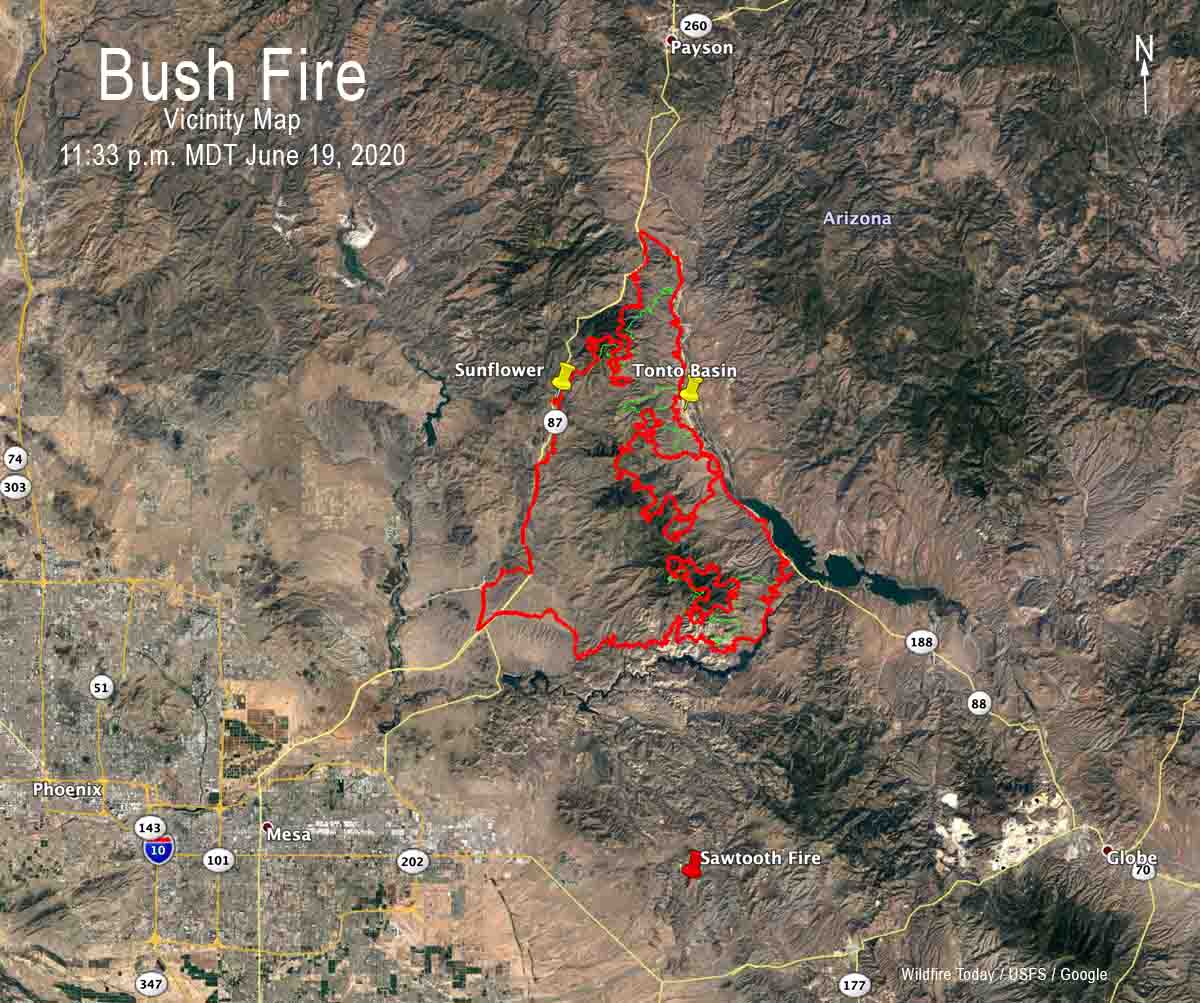
Wednesday night firing operations were conducted south of Sunflower near Highway 87, near the fire lookout and communication facilities on Mt. Ord (2 miles north of the fire), and along Highway 188 south of Tonto Basin and Punkin Center. Fire is now established along approximately 10 miles of the west side of Highway 188.

For all articles on Wildfire Today about the Bush Fire northeast of Phoenix including the most recent, click here.

About 10 miles north of the fire fire officials are preparing areas around Jake’s Corner near the intersection of Highways 188 and 87 for burning out in order to protect structures.

Bush Fire Map 254 am MDT June 18, 2020
The red line was the perimeter of the Bush Fire detected by a mapping flight at 11:49 p.m. MDT June 17. The yellow line was the perimeter detected by a mapping flight at 11:12 p.m. MDT June 16. The red dots represent heat detected by a satellite at 2:54 a.m. MDT June 18.

A fixed wing mapping flight at 11:49 p.m. Wednesday night determined that the Bush Fire had burned 114,941 acres, an increase of over 25,000 acres in 24 hours.


(UPDATED at 7:21 p.m. MDT June 17, 2020)

Bush Fire map Phoenix
The red line was the perimeter of the Bush Fire detected by a mapping flight at 11:12 p.m. MDT June 16. The yellow line was the perimeter detected by a mapping flight at 12:45 a.m. MDT June 16. The orange and red dots represent heat detected by a satellite on June 17.

The Bush Fire east of Phoenix has been very active on Wednesday, chewing up more vegetation on the north, east, and south sides.

Between the time of the fixed wing mapping flight at 11:46 p.m. MDT June 16 and a satellite overflight at 2:30 p.m. June 17 the northernmost point of the blaze moved about three miles to the north-northeast, roughly parallel to Highway 87. During that same time frame the east side spread down the east side of Four Peaks and reached Highway 188. At 2:30 there was fire along approximately four miles of the highway at the north end of Theodore Roosevelt Lake four miles south of Tonto Basin. It is likely that firefighters helped tie in the fire with the highway by burning out, a tactic intended to remove the fuel ahead of the main fire in order to check its spread, preventing it from crossing the road.

Late Wednesday afternoon several large air tankers and helicopters were working on the south side of the fire west of Apache Lake north of the Salt River. This is most likely an attempt to keep the fire from crossing the river and moving into the Tortilla Flat area along Highway 88. If it does cross the river putting this huge fire out becomes much more complicated.

A Type 2 Incident Management Team has been managing the fire, but Wednesday afternoon the Southwest Coordination Center announced that a higher level team, a Type 1 Team, has been ordered with Alan Sinclair as Incident Commander. It has been unusual to have the lesser qualified team on this very large fire for this long as it approaches megafire status, 100,000 acres. Typically in a situation like this the incoming team will not assume command until Thursday or possibly even Friday, depending on how quickly they assemble (except those working remotely) and transition with the existing team members.


(Originally published at 10:07 a.m. MDT June 17, 2020)

Map of the Bush Fire
3-D map of the Bush Fire at 3 a.m. MDT June 17, 2020 (the red line and red areas). The yellow line was the perimeter about 24 hour before. Data from USFS mapping flight and NASA satellites.

The “Bush Fire” east of Phoenix was very active again Tuesday and Tuesday night, spreading to the south, north, and east, moving across the iconic Four Peaks.

The fire spread aggressively north on the east side of Highway 87 to Boulder Pass coming to within two miles of the community of Sunflower.

For all articles on Wildfire Today about the Bush Fire northeast of Phoenix including the most recent, click here.

After a fixed wing aircraft mapping flight at 11:12 p.m. MDT June 16, a satellite overflight at 3 a.m. MDT June 17 revealed that the fire continued to move to the north and east. During that four-hour period satellite data showed that it spread two miles downhill almost reaching Highway 188 at the north end of Theodore Roosevelt Lake.

Map of the Bush Fire
Map of the Bush Fire at 3 a.m. MDT June 17, 2020 (red line and red area). The yellow line was the perimeter about 24 hour before. Data from USFS mapping flight and NASA satellites.

A Type 2 Incident Management team lead by Incident Commander Mark Bernal is managing the fire which was mapped Tuesday night at 89,058 acres.

Resources assigned to the fire according to the National Situation Report include 14 hand crews, 26 engines, and no helicopters for a total of 541 personnel.

There are no reports of structures being destroyed. Sections of Highways 87, 88, and 188 are closed due to the fire.

Information about evacuations that are in effect can be found at the official Facebook page for the fire.

The weather forecast for the fire area on Wednesday predicts 99 degrees, 8 percent relative humidity, and winds out of the south switching to the southwest in the afternoon at 13 mph gusting to 20 mph.

Bush fire size Arizona


Walker Fire burns hundreds of acres west of Angels Camp, CA

(UPDATED at 7:28 a.m. PDT June 17, 2020)

Walker Fire map California
Map showing heat detected on the Walker Fire by a satellite at 2:12 a.m. PDT June 17, 2020.

The relative humidity at a weather station on Hogan Dam Road near the Walker Fire increased early Wednesday morning, climbing to 74 percent. That will change later in the day under a Red Flag Warning with predictions for 12 to 17 percent in the afternoon with northwest winds increasing to 15 mph on ridgetops with gusts to 24 mph.

As you can see in the photo above taken Wednesday morning there was much less activity on the fire compared with Tuesday evening.

Walker Fire California
The Walker Fire as seen from Upper Bear at 6:50 a.m. PDT June 17, 2020.

Firefighters planned for a substantial effort on Wednesday, placing an overnight order for 45 fire engines, 20 hand crews, four air tankers, and several helicopters.

There has been no update from CAL FIRE since Tuesday evening when they said the fire had burned 1,000 acres.


(Originally published at 8:01 p.m. PDT June 16, 2020)

Walker Fire in Calaveras County, CA
Air Tanker 137, a B-737, maneuvers over the Walker Fire at 7:28 PDT June 16, 2020.

The California Department of Forestry and Fire Protection is battling the Walker Fire that broke out Tuesday afternoon about 10 miles northwest of Angels Camp and 29 miles east-northeast of Stockton.

The fire grew rapidly and by 7:30 p.m. firefighters estimated it had burned approximately 1,000 acres and described the rate of spread as “critical”, but were optimistic about making good progress in the coming hours. Numerous hand crews, engines, dozers, air tankers, and helicopters have been requested or are on scene.

Walker Fire in Calaveras County, CA map
Map showing the approximate location of the Walker Fire in Calaveras County, California.

The fire is close enough to the Upper Bear Alert Wildfire camera that excellent photos are available.

Walker Fire in Calaveras County, CA
Walker Fire at 7:25 PDT June 16, 2020.

Walker Fire in Calaveras County, CA

Walker Fire in Calaveras County, CA
Walker Fire at 6:13 PDT June 16, 2020.


Walker Fire in Calaveras County, CA
Spot fires were plentiful.

“Bush Fire” northeast of Phoenix spreads east toward Browns Peak

The fire was mapped by a fixed wing aircraft Monday night at 64,513 acres, an increase of 28,256 acres in 24 hours

(UPDATED at 6:37 p.m. MDT June 16, 2020)

 Tuesday afternoon the Maricopa County Sheriff’s Office issued an additional evacuation order, this time for an area on the south side of the Bush Fire  — Apache Lake north of Highway 88:

Apache Lake evacuation Bush Fire

More information about the evacuation can be found at the official Facebook page for the fire.

map Bush Fire Arizona Phoenix
Map showing the approximate location of the Bush Fire at 2:28 p.m. MDT June 16, 2020. It is based on heat detected by satellites. This unofficial map should not be used to make decisions about safety or evacuation.

For all articles on Wildfire Today about the Bush Fire northeast of Phoenix including the most recent, click here.


(UPDATED at 2:26 p.m. MDT June 16, 2020)

north side of the Bush Fire
Map showing the approximate location of the north side of the Bush Fire at 12:50 pm MDT June 16, 2020.

Additional evacuations have been ordered for the Bush Fire.

From the Maricopa County Sheriff’s Office at about 1:30 p.m. MDT June 16, 2020:

ATTENTION: EVACUATE NOW

A “Go” notice has been issued in the area of Sunflower due to the Bush Wildfire burning along State Route 87. Residents in the Sunflower area should evacuate now. Grab your emergency Go-kit and go to your relocation area or with friends/family.

The Red Cross Evacuation Center has not been set up in Payson at this time. Drive with care and follow the directions of emergency personnel.

Just before the Sheriff’s Office issued the notice above, this was in another message about the new evacuation:

Evacuated residents should proceed north towards Payson. Proceed to the Payson Police Department at 303 N. Beeline Highway, Payson, AZ. 85541. Drive with care and follow the directions of emergency personnel.

More information about the evacuation can be found at the official Facebook page for the fire.

As of Monday night the Bush Fire had burned over 64,000 acres northeast of Phoenix, Arizona.


(Originally published at 8:07 MDT June 16, 2020)

Bush Fire map Phoenix Arizona 3-D
3-D map showing the perimeter (in red) of the Bush Fire looking northeast at 11:46 p.m. MDT June 15, 2020. The yellow line was the perimeter 24 hours before.

The “Bush Fire” northeast of Phoenix grew substantially Monday adding another 28,256 acres to bring the total to 64,513 acres. All of the growth was on the north and east sides, spreading away from the greater Phoenix area, but moving closer to the communities north of Theodore Roosevelt Lake, including Tonto Basin and Punkin Center.

For all articles on Wildfire Today about the Bush Fire northeast of Phoenix including the most recent, click here.

The fire is in the Tonto National Forest, with much of it within the Four Peaks Wilderness. The blaze has already burned over Boulder Mountain and Pine Mountain, and is close to reaching Brother Peak and Browns Peak, the highest point in the Wilderness at 7,659 feet.

On June 15 the Gila County Health and Emergency Department announced the evacuation of Tonto Basin and Punkin Center from Highway 188 and A-Cross Road to Highway 188 at Rambo Realty. The Sheriff’s office has more information about evacuations on their Facebook page.

Bush Fire map Phoenix Arizona
Map showing the perimeter of the Bush Fire (in red) at 11:46 p.m. MDT June 15, 2020. The yellow line was the perimeter 24 hours before.

A Type 2 Incident Management Team, Southwest Team 5, assumed command of the fire Monday morning.

The fire started June 13 at 2:00 p.m. near the intersection of Bush Highway and Highway 87. The cause listed on InciWeb is “human caused, vehicle fire”.

As of Monday, no structures have been damaged or destroyed.

Hot and dry weather is expected for the next several days with winds out of the Southwest.  Tuesday may bring red flag conditions which will cause additional challenges for firefighters.

Bush Fire Arizona
Bush Fire as seen from Roosevelt Marina June 15, 2020 Gila County Sheriff’s Office photo by Sgt. Don Engler.

The Bush Fire has exceeded the size of the fire that for six years held the record for the largest fire in Arizona, the 61,000-acre Lone Fire, also in the Four Peaks Wilderness. It was caused April 27th, 1996 by a party of two campers who left a campfire unattended near Lone Pine Saddle. That record was blown away in 2002 by the 468,638-acre Rodeo-Chediski Fire at Show Low.

Maps of the Bush Fire northeast of Phoenix

Maps of the Bush Fire, northeast of Phoenix.

(UPDATED at 1:21 p.m. MDT June 21, 2020)

Central and Bush Fires Phoenix
The Central and Bush Fires in the Phoenix Area, June 21, 2020.

(UPDATED at 10:52 a.m. MDT June 20,2020)

Friday night’s mapping flight determined that the Bush Fire had burned 174,397 acres, an increase of 23,397 acres in 24 hours.

For all articles on Wildfire Today about the Bush Fire northeast of Phoenix including the most recent, click here.


(UPDATED at 8:23 a.m. MDT June 19, 2020)

Bush Fire map June 19, 2020 wildfire Arizona Phoenix Jakes Corner
The red line was the perimeter of the Bush Fire detected by a mapping flight at 11:18 p.m. MDT June 18. The yellow line was the perimeter detected by a mapping flight at 11:49 p.m. MDT June 17. The red dots represent heat detected by a satellite at 3:24 a.m. MDT June 19.

The fire has grown to 151,075 acres.


(UPDATED at 8:04 p.m. MDT June 18, 2020)

Bush Fire map 3 pm MDT June 18, 2020 wildfire Arizona Phoenix
The red line was the perimeter of the Bush Fire detected by a mapping flight at 11:49 p.m. MDT June 17. The yellow line was the perimeter detected by a mapping flight at 11:12 p.m. MDT June 16. The red dots represent heat detected by a satellite at 3 p.m. MDT June 18.

(UPDATED at 7:42 a.m. MDT June 18, 2020)

Bush Fire Vicinity Map
Vicinity map for the Bush Fire, 11:49 p.m. MDT June 17, 2020.
Bush Fire Map 254 am MDT June 18, 2020
The red line was the perimeter of the Bush Fire detected by a mapping flight at 11:49 p.m. MDT June 17. The yellow line was the perimeter detected by a mapping flight at 11:12 p.m. MDT June 16. The red dots represent heat detected by a satellite at 2:54 a.m. MDT June 18.

For all articles on Wildfire Today about the Bush Fire northeast of Phoenix including the most recent, click here.


(UPDATED at 7:25 p.m. MDT June 17, 2020)

Bush Fire map Phoenix
The red line was the perimeter of the Bush Fire detected by a mapping flight at 11:12 p.m. MDT June 16. The yellow line was the perimeter detected by a mapping flight at 12:45 a.m. MDT June 16. The orange and red dots represent heat detected by a satellite on June 17.

(UPDATED at 9:20 a.m. MDT June 17, 2020)

Map of the Bush Fire
Map of the Bush Fire at 3 a.m. MDT June 17, 2020. Data from USFS mapping flight and NASA satellites.
Map of the Bush Fire
3-D map of the Bush Fire at 3 a.m. MDT June 17, 2020. Data from USFS mapping flight and NASA satellites.

For all articles on Wildfire Today about the Bush Fire northeast of Phoenix including the most recent, click here.

map Bush Fire Arizona Phoenix
Map showing the approximate location of the Bush Fire at 2:28 p.m. MDT June 16, 2020. It is based on heat detected by satellites. This unofficial map should not be used to make decisions about safety or evacuation.
north side of the Bush Fire
Map showing the approximate location of the north side of the Bush Fire at 12:50 pm MDT June 16, 2020.
Bush Fire map Phoenix Arizona 3-D
3-D map showing the perimeter (in red) of the Bush Fire looking northeast at 11:46 p.m. MDT June 15, 2020. The yellow line was the perimeter 24 hours before.
Bush Fire map Phoenix Arizona
Map showing the perimeter of the Bush Fire (in red) at 11:46 p.m. MDT June 15, 2020. The yellow line was the perimeter 24 hours before.

A mapping flight Monday night at 11:46 determined that the Bush Fire had burned 64,513 acres.

satellite photo Bush Fire northeast of Phoenix
GOES-17 satellite photo of the Bush Fire northeast of Phoenix at 6:56 p.m. MDT June 15, 2020.
3-D Map of the Bush Fire northeast of Phoenix
3-D Map of the Bush Fire northeast of Phoenix looking southwest. The red line was the perimeter at 11:25 p.m. MDT June 14, 2020. The green line was the additional growth through 1:24 pm MDT June 15, 2020.
Map of the Bush Fire northeast of Phoenix
Map of the Bush Fire northeast of Phoenix. The red line was the perimeter at 11:25 p.m. MDT June 14, 2020. The green line was the additional growth through 1:24 pm MDT June 15, 2020.

Lost Creek Fire burns hundreds of acres west of Cody, WY

23 miles east of Yellowstone’s east entrance

3-D map of the Lost Creek Fire
3-D map of the Lost Creek Fire east of Yellowstone National Park, based on a mapping flight at 2:36 a.m. MDT June 14, 2020.

The Lost Creek Fire in northwest Wyoming had burned 591 acres when a mapping aircraft overflew the fire at 2:36 Sunday morning. The blaze is on the south side of Highway 14/16/20, 23 miles west of Cody and 23 miles east of Yellowstone National Park’s east entrance. It was reported at 12:45 p.m. on Saturday.

Sunday morning the resources assigned or working on the fire included two Type 1 hand crews, multiple engines, two heavy air tankers, three single engine air tankers, two Type 1 helicopters, and one Type 3 helicopter. The Bill Cody Ranch and Rimrock Dude Ranch remain under an evacuation order.

A public meeting will be held at 5:00 p.m. Sunday at the Sheep Mountain Day Use Area of Buffalo Bill State Park. Due to ongoing health concerns, fire managers are asking the public to limit attendance to those directly impacted, and to limit the number of people per household that attend.

Restricting the number of attendees makes sense, but is certainly a change from the pre-COVID policy. It could be helpful if it were also live-streamed and available on the internet.

So far there has been no report of the highway being closed or restricting access to the east entrance of Yellowstone National Park. Here is a link to Wyoming road information.

Traffic Lost Creek Fire

Google Maps showed slowing of traffic on the highway at 1:02 p.m. Sunday.

The map below shows the location of the fire relative to Yellowstone and Cody.

Vicinity map of the Lost Creek Fire
Vicinity map of the Lost Creek Fire west of Cody, Wyoming.

“Bush Fire” closes SR 87 northeast of Phoenix

Evacuations are in effect

(UPDATED at 6:30 p.m. MDT June 15, 2020)

3-D Map of the Bush Fire northeast of Phoenix
3-D Map of the Bush Fire northeast of Phoenix looking southwest. The red line was the perimeter at 11:25 p.m. MDT June 14, 2020. The green line was the additional growth through 1:24 pm MDT June 15, 2020.

Monday afternoon the Incident Management Team on the Bush Fire announced that it had burned 37,900 acres.

For all articles on Wildfire Today about the Bush Fire northeast of Phoenix including the most recent, click here.


(UPDATED at 3:13 p.m. MDT June 15, 2020)

Bush Fire Map Phoenix Arizona wildfire
Map showing the perimeter of the Bush Fire at 11:25 p.m. MDT June 14, 2020.

Here is a zoomed-in version of the map showing the location of the Bush Fire northeast of Phoenix at 11:25 p.m. MDT June 14, 2020. The data is from a fixed wing mapping aircraft.

For all articles on Wildfire Today about the Bush Fire northeast of Phoenix including the most recent, click here.


(UPDATED at 1:13 p.m. MDT June 15, 2020)

Bush Fire, northeast of Phoenix
Bush Fire, northeast of Phoenix, June 14, 2020. Inciweb photo.

At 9:46 a.m. MST on Monday a notice from the Gila County Sheriff’s Office said, “The Tonto Basin and Punkin Center area are being evacuated. If you need to travel into the evacuated areas to remove livestock and or property you will be allowed to do so.”

A notice from the Sheriff’s office also reported, “Highway 87 from the Bush Highway M/P 199 north bound and south bound to BIA 101 entrance to the Matazal Casino in Payson is closed due to the fire on Highway 87. Only local traffic will be permitted. Residents in the local areas i.e. Rye, Gisela, Deer Creek, Ox Bow will be permitted to travel into Payson and return home. The Junction of Highway 87 and Highway 188 is closed. Highway 188 to the Roosevelt Dam is closed.”

The weather is not helping the firefighters. The forecast for the fire area on Monday is for temperatures of 81 to 91, relative humidity 12 to 17 percent, and no chance of rain. The winds will become southwesterly at 6 to 15 mph by the late morning/early afternoon. Gusts of 20-25 mph will occur over most of the mountain range, but ridgetops could see gusts nearing 30 mph. Monday night the winds will be southwest at 5 to 10 mph.


(UPDATED at 7:10 a.m. MDT June 15, 2020)

Bush Fire map
Bush Fire Permeter at 11:25 p.m. MDT June 14, 2020.
bush fire phoenix
Bush Fire northeast of Phoenix, Arizona. Photo by James Stamsek, June 14, 2020.

The Bush Fire was mapped at 36,257 acres Sunday night. We will post more about this fire later.


(Originally published at 9:36 a.m. MDT June 14, 2020)

Bush Fire Highway 87 Phoenix
Map showing the approximate location of the “Bush Fire” north of Mesa, Arizona. If light fuels burned and then cooled before being detected by the next satellite overflight, the fire could be larger than shown.

Both lanes of State Route 87 are closed northeast of Phoenix, Arizona due to a vegetation fire that was unfortunately named “Bush Fire”.

The northbound lanes are closed at Bush Highway at milepost 199, according to the Arizona Department of Transportation. The southbound highway is currently closed at State Route 188.

There is no estimated time to reopen. Drivers are encouraged to use an alternate route, such as US 60 and SR 188 through Globe, or delay travel if possible.

Bush Fire Highway 87 Phoenix
Bush Fire, June 13, 2020. Tonto National Forest photo.
Bush Fire Highway 87 Phoenix
Bush Fire, June 13, 2020. Tonto National Forest photo.