Long bushfire season wears down firefighters in Queensland and Western Australia

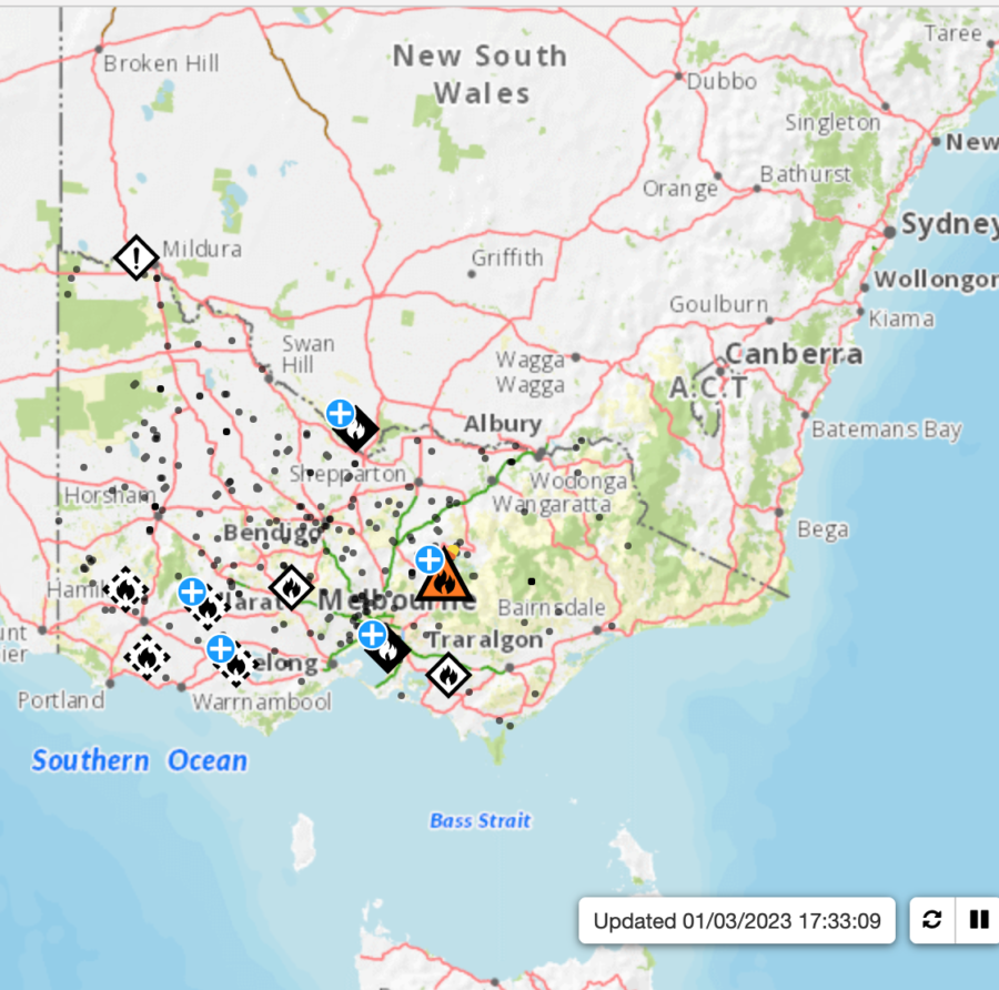
State fire officials are airing concerns about firefighter fatigue as southwest Queensland heads into an “unprecedented” prolonged fire season this autumn, and South West Rural Fire Service superintendent Wayne Waltisbuhl told ABC News that he could not remember the last time a fire season continued into March.

“It’s usually finished by late January, early February,” he said. “It’s just very dry conditions.”

Waltisbuhl said the season could continue for the next six weeks, and the Bureau of Meteorology is predicting higher than median average temperatures for the March-to-May period. “We’ll have some really peak days with high fire danger weather and some lulls.”

In Western Australia, the Department of Fire and Emergency Services (DFES) is disputing claims it doesn’t have the resources to handle the fires burning across the state. The West Australian reported that it took 200 firefighters to control a fire at Neergabby, near the popular tourist destination of Moore River. DFES deputy commissioner operations Craig Waters said that Western Australia is still “well-protected and well-resourced” and can provide a rapid response to such incidents.

Shadow Emergency Services Minister Martin Aldridge said that five trucks had been “mothballed” at city stations while the fires burned, but Waters disputed that. He said the five engines were crewed and available on Saturday and Sunday.

Those fires started the day after the United Professional Firefighters Union (UPFU) warned that the State could face a catastrophe over the weekend, after trucks were stripped and crews benched on Friday because of firefighter exhaustion. “DFES had sufficient resources over the weekend,” explained Waters, “to manage the effects of the industrial action initiated by the UPFU during the high-threat period.”

He said that in the metropolitan area, DFES has 139 vehicles across the career and volunteer brigades, with an additional 130 across local government bushfire brigades. He said that based on risk, together with the need to manage fatigue and staff rostering, DFES had decommissioned five firefighting vehicles in the metro area — for Friday only.

Waters said the state thus far had experienced only a moderate fire season, but he warned people not to be complacent. “There is still a long way to go, and Western Australia is incredibly hot and dry in summer, and the smallest flame can spark a devastating bushfire. Bushfires are burning for longer, and more intensely than we’ve seen in previous decades. Our firefighters do a tremendous job during bushfire season but we need people to take responsibility.”

Residents ordered to evacuate bushfires

Bushfires are burning out of control northeast of Melbourne, the coastal capital of the Australian state of Victoria, and 9News reported that some residents have been told to leave immediately. Meanwhile, people in Maintongoon also have been issued a “leave immediately” warning. Updates will be posted at the VicEmergency website.

Melbourne fires map
Map of Victoria bushfires

The Rural Fire Service (RFS) in New South Wales says some of the active bushfires are too dangerous to control, and that they may have been deliberately lit. The RFS has an interactive map online.

RFS map
RFS map of New South Wales incidents

A firefighting aircraft has been called up to fight two large and out-of-control bushfires believed to have been deliberately lit near Moonie in Queensland’s Western Downs, according to ABC.net.au news.

On Tuesday night the RFS was called to two fires in the Waar Waar State Forest and Cattle Creek, and South West Region RFS Superintendent Wayne Waltisbuhl said that fire crews notified police.

“Some of the crew who arrived on scene last night observed some people in the area in a car and they took off very quickly,” he said. “That was suspicious at the time the fires were lit, so that information has been passed to police to follow up.”

Community near Heppner, Oregon first in Morrow County to earn Firewise designation

A bolt of lightning struck a tree just outside Bruce Wilcox’s home in Morrow County, Oregon last year, sending shards of wood flying 40 yards away. “It didn’t start a fire,” he said. “It just hit that tree and went to ground. But we were lucky.” Lightning-ignited fires are common in north-central Oregon, and Wilcox lives about 16 miles south of Heppner — home to the nearest fire department. Wilcox is helping his community, known locally as Blake Ranch, become the county’s first to join Firewise USA. He told Oregon Public Broadcasting that the Firewise program could be the key to protecting nearby homes from the next big wildfire.

FIREWISEFirewise is sponsored by the National Fire Protection Association (NFPA), and the Oregon Department of Forestry (ODF) manages the program at the state level. Through training and local fire prevention projects, Firewise encourages property owners to take proactive measures to prevent fires from destroying their homes and businesses. Many of Oregon’s small and isolated communities have achieved Firewise designation.

Jessica Prakke with ODF said these sparsely populated communities are among the target areas for the state. “We’re definitely trying to reach those smaller communities that are in the wildland/urban interface, because they can be the most susceptible to wildfire.”

In Blake Ranch, Wilcox contacted ODF after he read about a community in northeast Oregon’s Wallowa County that was participating. Since then, ODF has sent foresters to assess Blake Ranch properties for fire readiness, and some residents have taken a wildfire prevention class. Prakke said ODF doesn’t usually initiate the process of turning communities into Firewise sites, because the agency needs community buy-in to make the program work. Wilcox noted that some local residents are a little skeptical — they suspect the program might require them to remove trees they want to keep. But Wilcox thinks they’ll come around.

Morrow County FIREWISE

The Firewise program has an interactive map on the NFPA website with details about designated sites and their locations across the country, and it’s interesting to compare locations with known fire-danger areas. There’s a cluster of sites, for example, north of Paradise in northern California. One of the sites, Falcons Pointe Drive, is near Upper Bidwell Park in Chico. That community’s participation in the Firewise program began in September of 2022.

FIREWISE map

There are very few sites in Nevada and zero in North Dakota; about half of Colorado’s map is covered with little Firewise icons. While Oregon’s west side is not really known for severe wildfires, that side of the state surely proved the exception over the last few years, and it’s crowded with Firewise sites, while the east side of Oregon, no stranger to major fires, has only a few. Blake Ranch was just added to the list in December, and the numbers grow as people learn about neighborhoods and towns devastated by wildfires.

“The number of conversations I have had since Paradise has skyrocketed,” said Chris Chambers, Forest Division Chief in Ashland, Oregon. Residents and local officials in and around Ashland tend to be a little more fire-savvy than in many areas; they have a history with interface fires. Jefferson Public Radio reported, about a year after wildfire leveled the town of Paradise, that Chambers spoke to a throng of people at a sold-out screening of the documentary Fire In Paradise at a theater in downtown Ashland, just north of the California state line. Although the Camp Fire was more than 200 miles south, Chambers says it alarmed Ashland residents;  it’s a small, woodsy town that, like Paradise, is tucked into forest.

“People have really become concerned,” Chambers said. “I just hope that translates into lasting awareness in the sense that people take responsibility for the condition of their property.”

County Cork fire brigades work through the night on gorse fires

On a windy Sunday on the west side of County Cork, Ireland, satellite hotspots were highlighting what firefighters were facing in person, with reports of nearly 100 fires breaking out in gorse and related fuels, beginning February 26 and burning into the next morning.

Burning gorse in Cashelfean, County Cork, Ireland. Photo: Cork County Council.

Significant nighttime fire growth in highly flammable gorse brush threatened a radar and aviation-control installation and involved six West Cork fire brigades and other resources, including the Irish Aviation Centre firefighters on Mount Gabriel.

Heat detection and burned area mapping from the Global Wildfire Information System highlights widespread fire ignitions on the West Cork peninsulas from Feb. 26-27, 2023.

The burning of vegetation from March 1 through August 31 is a violation of the Wildlife Acts, but a spokesperson for Cork County Council warned that intentionally set fires during last weekend’s winds threatened houses, a radar installation, livestock and wildlife, not to mention the risk to firefighters and the drawdown of resources for other emergencies.

Twitter correspondents also captured the flames.

For additional news reports, see https://www.rte.ie/news/regional/2023/0227/1359220-gorse-fires-cork/ and https://www.irishexaminer.com/news/munster/arid-41081189.html.

Along the west coast of the United States, gorse is a an invasive that also exhibits extreme fire behavior.

Hiker owes $300,000 for Arizona wildfire he started

There’s yet another dumb hiker in the news for starting a wildfire to signal rescuers after he got lost. Philip Powers, a resident of Tempe, Arizona, argued in court that the fire he set in 2018 was necessary to save his life. But a federal court found that he was so unprepared that he created his own emergency.

Backpacker Magazine reported that the 37-year-old hiker in the rugged Sycamore Canyon Wilderness northwest of Sedona, in late May 2018, had barely slept and had muscle cramps in his legs. He’d also found a rattlesnake in the sheepherder shack where he’d overnighted. It was 14 miles back to his car, he was out of food and water, and he had no cell signal. Powers later told a USFS law enforcement officer that he feared he was “done.”

2018 Sycamore Fire in Arizona, looking north. USFS photo.

He’d tried the night before to start a signal fire, but it quickly burned out. He tried again, piling dry foliage around the base of a snag and firing it up with his Bic lighter. He hoped that the dead tree would go up in flames, and someone would see it and come to his rescue. But the fire got away, tripled in size in one day, and quickly grew to 230 acres; the Sycamore Fire took over a week to contain. A federal district court recently convicted him for his actions in 2018, and Powers now owes the feds almost $300,000 in restitution — and a year of probation.

Fronteras Desk reported that Judge Camille Bibles didn’t buy the hiker’s excuses. “Had Powers engaged in adequate preparation in planning and carried adequate water, food and gear, he would not have found himself in his circumstances,” she wrote. “Thus, the court finds that Powers’ necessity defense fails, as he created the conditions necessitating the commission of the fires, and his subsequent rescue.”

Powers faced 3½ years in prison for the seven misdemeanors he was charged with. Judge Bibles sentenced him to seven concurrent one-year probation periods instead. He also owes the Forest Service more than $293,000 in restitution, which he will make in $200 monthly payments.

In addition, the judge ordered Powers to complete a hiking safety course.

According to 12News in Arizona, he’s already filed an appeal of his conviction.

Chile: Wildfires intensify, disaster impacts expand

Satellite analyses and Twitter reports indicate a rapid growth of disastrous wildfires in south-central Chile yesterday (February 3) and overnight.

In the past 24 hours, satellite-based estimates based on NASA FIRMS data  indicate that the largest fire spread 80 kilometers (50 miles) west and northwest, impacting an area of nearly 100,000 hectares (230,000 acres). The fires appear to have spread from Renaico northwest toward the Pacific Coast city of Lota, while burning past Santa Juana and likely crossing north over the Biobío River.

In this NASA FIRMS map, the oldest yellow heat signatures are 24 hours or earlier, the most recent are red.

24-hour fire spread of largest fire in the Santa Juana are of Chile on Feb. 4, 2023. NASA FIRMS.
24-hour fire growth along a 80 km/50 mile line of the largest fire in the Santa Juana are of Chile on Feb. 4, 2023. NASA FIRMS.

A larger map shows 24-hour fire detections for the affected regions of Biobío and La Araucanía. (And a reminder, as the FIRMS mapping tool, these heat signatures may overestimate fire size and activity, in part due to smoke columns and other factors.)

Overview of active fires in south-central Chile for the past 24 hours. Feb. 4, 2023. NASA FIRMS.

The fires detected by satellites are being confirmed via social media updates. As @HotshotWake reported via Twitter …

Also from February 3, @zoom_earth shared a satellite stream of fires and smoke…

The Associated Press reported that the death toll as of February 4 has risen to 22 with more than 500 injured. The state of catastrophe has expanded to include the La Araucanía region, which is south of Ñuble and Biobío regions that were already in a catastrophe declaration.