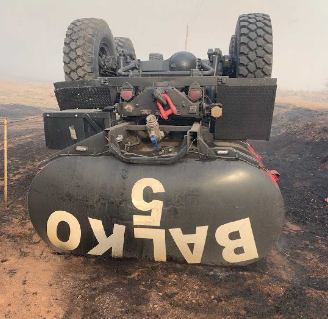
Rollover of Balko FD Engine 5 — Oklahoma, April 6, 2022. Photo courtesy of OK Forestry Services.
Updated at 8:30 p.m. CDT May 9, 2022
Just a few hours after we saw the notice from the Wildland Fire Lessons Learned Center and wrote the piece below about the rollover of an engine in Oklahoma on April 5, Mark informed us that one of the two injured firefighters, Jason Smith, passed away yesterday from his injuries.
Below is an excerpt from a Facebook post by Western Oklahoma Fire Coverage on May 8:
In memory of fallen Firefighter Jason Smith with the Balko Fire department. Just 33 days ago, while fighting the Beaver River Fire in Beaver County, two Balko firefighters were injured when their truck rolled over off of a 6’ embankment. They were flown to Lubbock, TX to the burn unit to receive treatment. Jason was finally able to come home at the end of last month, but today he lost the battle and succumbed to his injuries. Jason leaves behind his wife, 2 daughters and a 3 1/2 month old grandson Emmett that he was very proud of.
We send our sincere condolences to the family, friends, and co-workers of Mr. Smith.
5:08 p.m. CDT May 9, 2022
Two firefighters were injured and later burned in a fire engine rollover in Oklahoma. It happened in the state’s panhandle April 5 on the Beaver River Fire during the initial attack on a vegetation fire 11 miles west of Beaver. (This information was contained in a “24-hour report” about the incident which was distributed by the Wildland Fire Lessons Learned Center.)
Balko Volunteer Fire Department Engine 5 with two occupants veered slightly off the road onto a gravel shoulder that collapsed. As a result, the engine slid off an embankment approximately six feet in depth and rolled over on its top. Subsequently, an active area of the fire switched directions as it was impacted by strong variable winds. Prior to the fire arriving at the accident scene both occupants were able to self-extricate. However, they sustained 1st and 2nd degree burns to their arms and hands as the fire burned past. In addition, one victim possibly suffered a concussion during the vehicle rollover.
Both firefighters were evacuated from the incident by law enforcement and later flown by air ambulance to a burn center in Lubbock, Texas. Initially the victims were listed in critical condition. When the 24-hour report was issued the next day on April 6, 2022 they were conscious and in ‘Yellow’ status at the burn center.
Rollover of Balko FD Engine 5 — Oklahoma, April 6, 2022. Photo courtesy of OK Forestry Services.
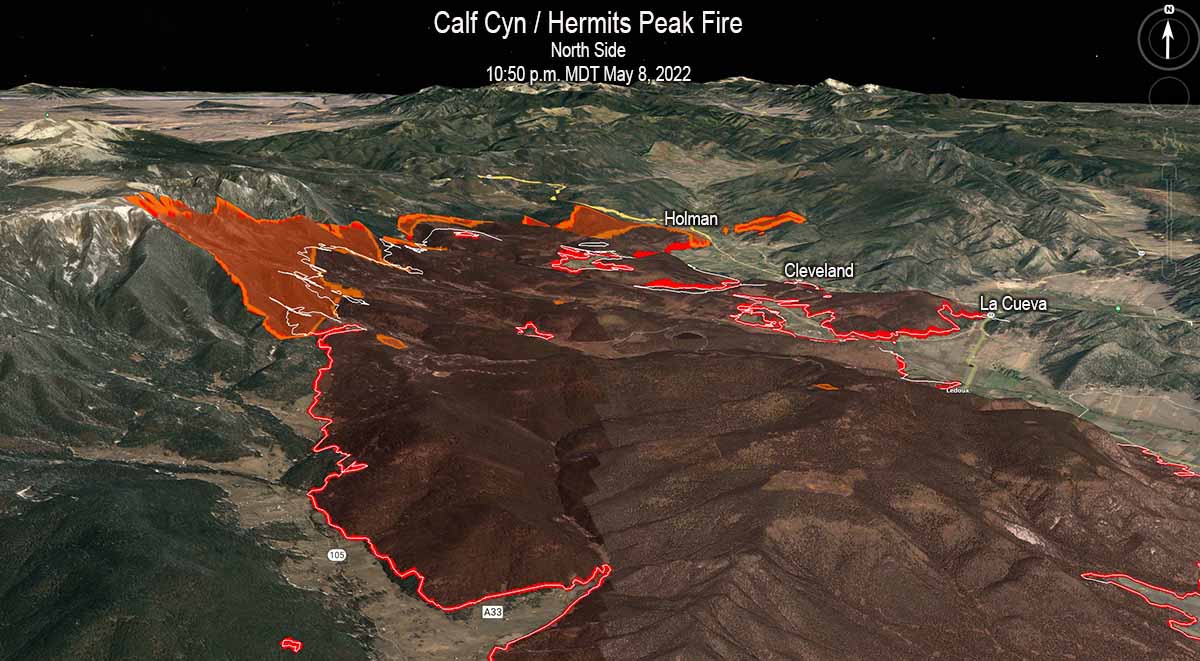
3-D map. The north side of the Calf Canyon / Hermits Peak Fire, looking north. The red line was the perimeter at 10:50 p.m. MDT May 8, 2022. The white line was the perimeter 24 hours before. The orange areas indicate extreme heat when the fire was mapped.
Updated to add the 3-D map of the north end of the Calf Canyon / Hermits Peak Fire.
To see all articles on Wildfire Today about the Calf Canyon / Hermits Peak Fire, including the most recent, click here.
Updated at 9:23 a.m. MDT May 9, 2022
Both of the large wildfires in Northern New Mexico were very active Sunday, pushed by the very strong winds.
Cerro Pelado Fire
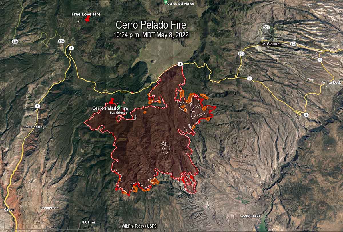
Map of the Cerro Pelado Fire. The red line was the perimeter at 10:24 p.m. MDT May 8, 2022. The white line was the perimeter 24 hours before. The orange areas indicate extreme heat when the fire was mapped.
The most significant spread of the Cerro Pelado Fire Sunday was on the northeast side south of Highway 4 where it spread for about a mile east and crossed the FR 289 road. When the fire was mapped at 10:24 p.m. Sunday a large spot fire had come very close to crossing the next road to the east, FR 287. The fire grew by more than 3,000 acres Sunday to bring the size up to 40,958 acres.
Calf Canyon / Hermits Peak Fire
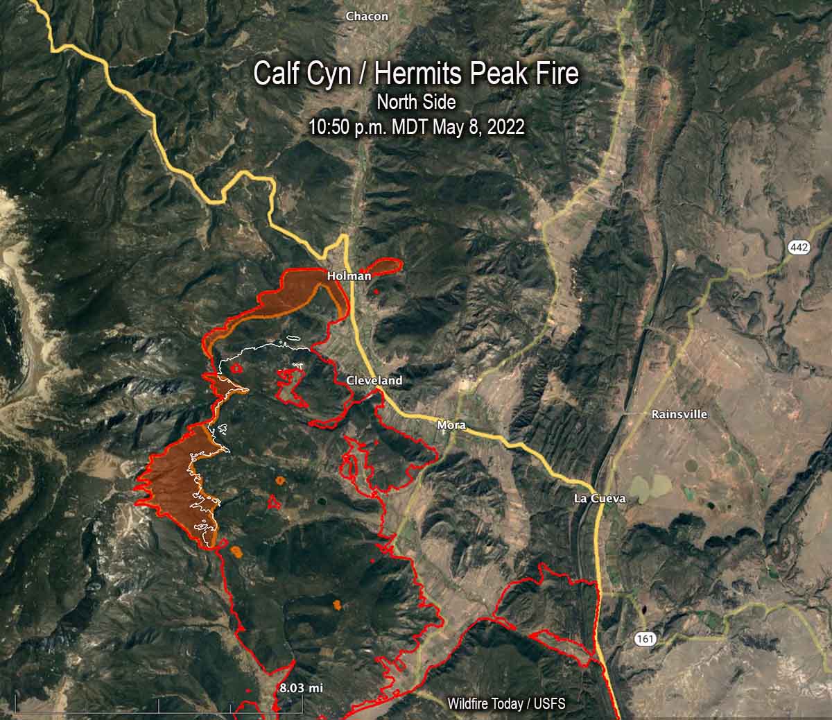
Map of the north side of the Calf Canyon / Hermits Peak Fire. The red line was the perimeter at 10:50 p.m. MDT May 8, 2022. The white line was the perimeter 24 hours before. The orange areas indicate extreme heat when the fire was mapped.
Most of the significant growth on the Calf Canyon / Hermits Peak Fire was on the north and south sides. When it was mapped at 10:50 p.m. on Sunday the north side, northwest of Cleveland, had advanced for about two miles further north coming close to Holman. There was a large 200-acre spot fire across Highway 518 east of Homan.
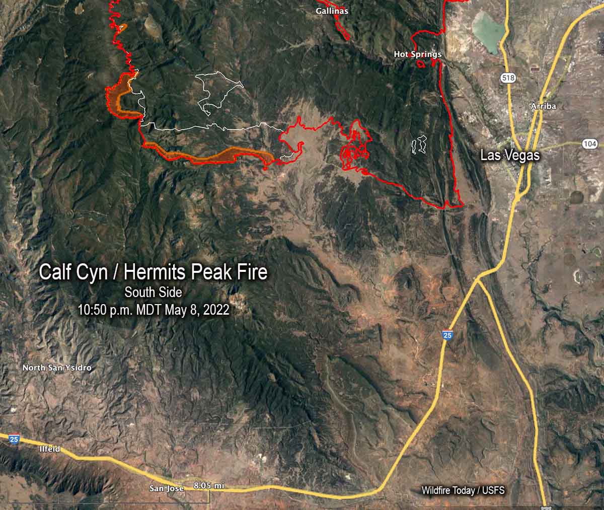
Map of the south side of the Calf Canyon / Hermits Peak Fire. The red line was the perimeter at 10:50 p.m. MDT May 8, 2022. The white line was the perimeter 24 hours before. The orange areas indicate extreme heat when the fire was mapped.
The east side of the Calf Canyon / Hermits Peak Fire still appears to be secure and the Sunday night map showed no change south of Mora and La Cueva near Highway 518. There was also no change near Las Vegas. But about 8 miles west of Las Vegas south of Highway 283 it spread south for an additional mile.
The fire grew by more than 13,000 acres Sunday to bring the size up to 189,767 acres.
Updated at 7:13 p.m. MDT May 8, 2022
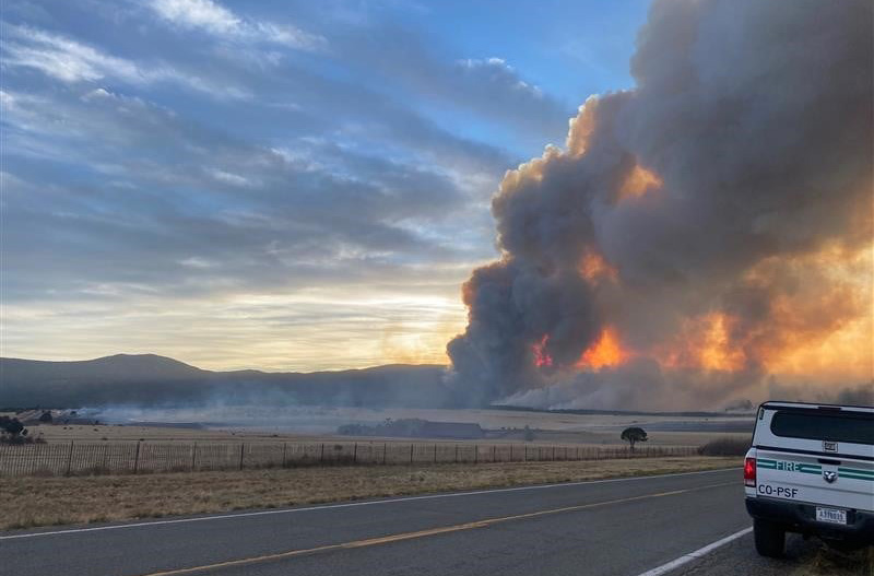
Calf Canyon / Hermits Peak Fire at Hwy. 283. Photo by Night Operations Section Chief Trainee. May, 2022.
Calf Canyon / Hermits Peak Fire
The Calf Canyon / Hermits Peak Fire near Las Vegas, New Mexico made it through Saturday’s wind event without any major devastating runs beyond the existing firelines, but it is not over yet. Red Flag Warnings are again in place Sunday for strong winds, low humidity, and very dry vegetation. The forecast for Sunday and Monday is for sustained 32 mph winds gusting out of the west-southwest at 40 to 48 mph with 8 percent relative humidity.
Operations Section Chief Todd Abel said Saturday evening that one of the most active areas on the fire was on the southwest side near Highway 283. He also said all aircraft working on the fire had to be shut down around noon Saturday when the winds became too turbulent.
The fire has burned 176,000 acres.
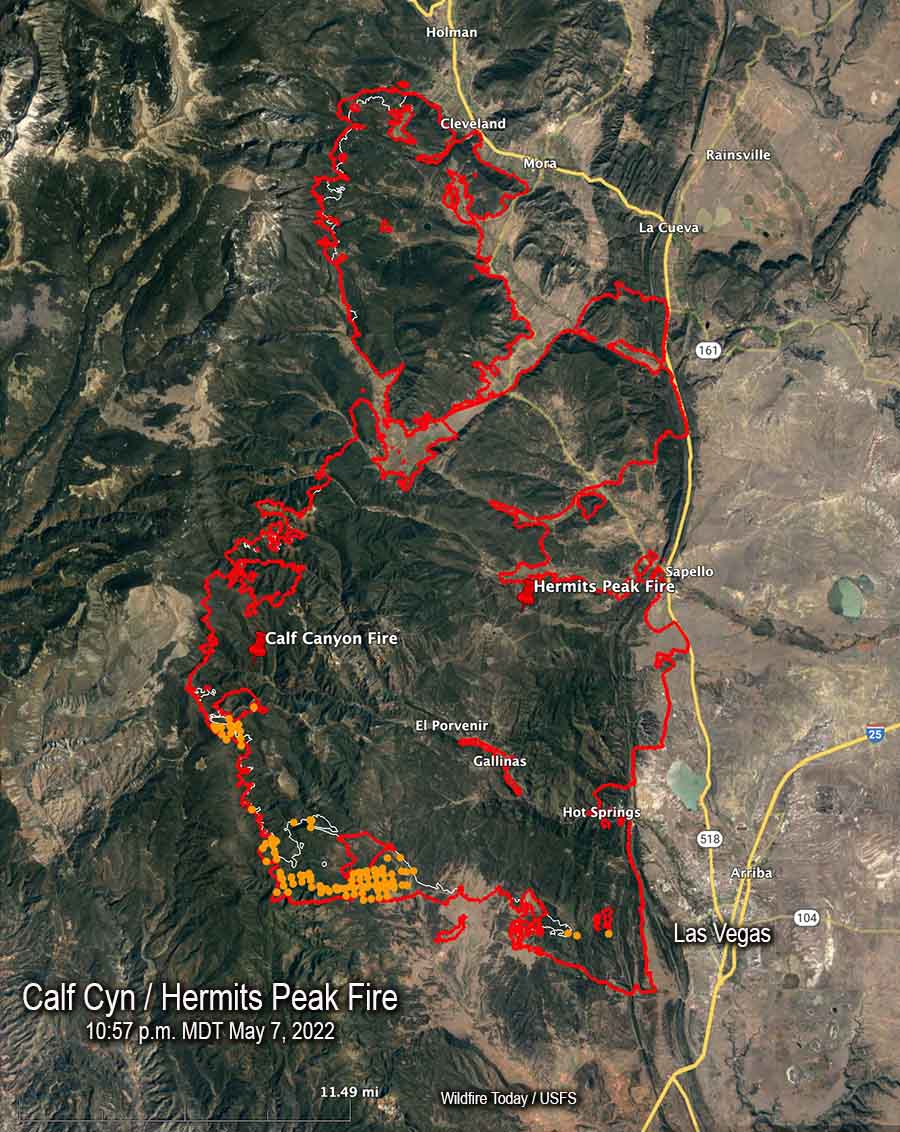
Map of the Calf Canyon and Hermits Peak Fire. The red line was the perimeter at 10:57 p.m. MDT May 7, 2022. The white line was the perimeter about 48 hours before. The tan dots represent heat detected by a satellite during the 24-hour period ending at 6 a.m. MDT May 8, however clouds as the satellite passed over may have prevented some detections.
Cerro Pelado Fire
On Friday and Saturday most of the spread of the Cerro Pelado Fire was on the northeast side south of Highway 4, and on the southwest side. The 37,525-acre blaze is seven miles west-southwest of Los Alamos, New Mexico.
On the eastern side of the fire the FR 289 road is considered a primary line as the fire continued to advance in that direction pushed by 35 mph winds. A spot fire crossed the road late Saturday afternoon. Crews working that night shift described conditions in the area as “unbearable” due to wind, dust, smoke, and heat. Crews later engaged the spot fire at 3:00 a.m. Sunday when visibility had improved. Most of the movement to the east occurred in steep canyons. FR 289 has been prepped and plumbed with extensive hose lines.
Crews are coordinating with the National Park Service for structure protection in Bandelier National Monument and Valles Caldera National Preserve.
A Red Flag Warning is in effect for Sunday. The forecast for the fire area is for 39 mph winds gusting out of the west-southwest at up to 55 mph with relative humidity as low as 9 percent. On Monday the wind speeds will drop to 24 mph with gusts of 31 to 39 mph from the west-southwest.
Most of the blaze is in the footprint of the Las Conchas Fire that burned 156,593 acres in 2011. In a trial jurors found that two power companies were 95 percent responsible for starting that fire and the U.S. Forest Service was 5 percent responsible. The cause of the current Cerro Pelado Fire is listed as unknown.
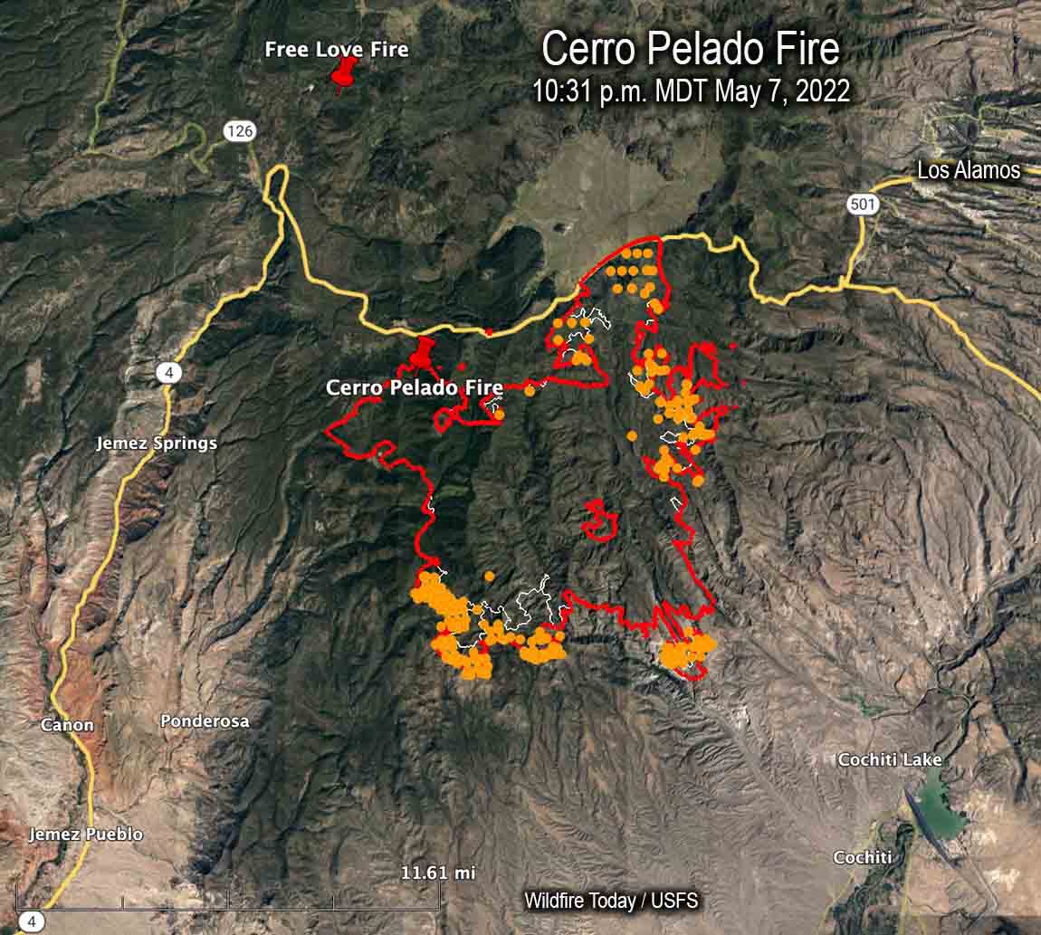
Map of the Cerro Pelado Fire. The red line was the perimeter at 10:31 p.m. MDT May 7, 2022. The white line was the perimeter about 48 hours before. The tan dots represent heat detected by a satellite during the 24-hour period ending at 6 a.m. MDT May 8, however clouds as the satellite passed over may have prevented some detections.
Winds gusting at more than 40 mph will test firelines on the east and northeast sides of the fire
Updated 5:32 p.m. MDT May 6, 2022
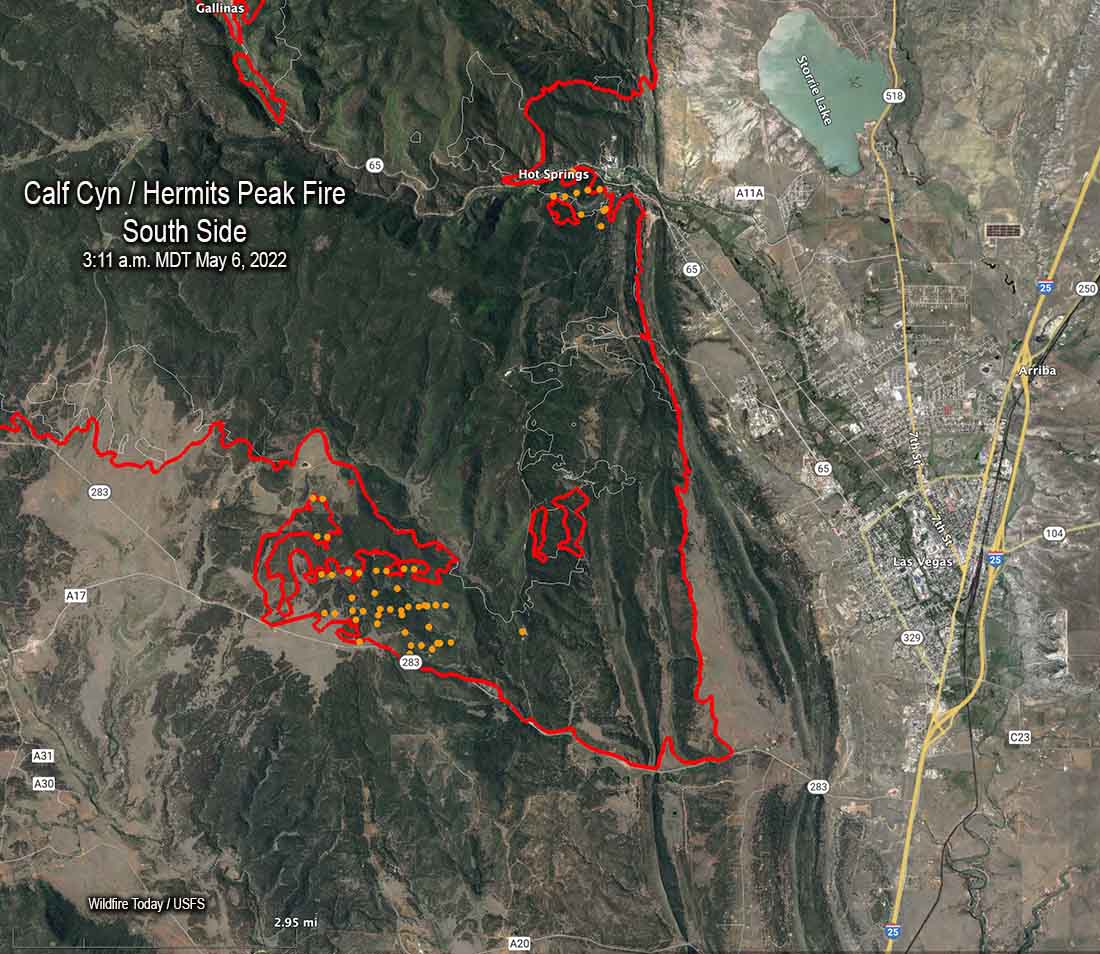
Map of the south side of the Calf Canyon / Hermits Peak Fire. The red line was the perimeter at 10:15 p.m. May 5. The white line was the perimeter two days before. The brown dots represent heat detected by satellites during the 24-hour period ending at 3:11 a.m. MDT May 6, 2022.
Most of the growth of the Calf Canyon / Hermits Peak Fire on Wednesday and Thursday was in three areas, on the north side west of Mora, on the southwest side near Bear Mountain, and the southeast side west of Las Vegas. Most of the additional acres near Las Vegas were a result of large burning operations conducted by firefighters to secure the fire edge. A mapping flight Thursday night determined that the fire had burned 168,009 acres, an increase of about 8,000 acres over the previous two days.
An area that is of concern to many residents in the area, the portion of the fire near Las Vegas, is “looking awesome”, said Operations Section Chief Todd Abel in a Friday morning briefing, implying there was not much active fire and the control lines are in place and holding.
Mr. Able said the weather and fire conditions have allowed firefighters to build direct fireline on the north side just west of the community of Cleveland, which is good news with strong winds in the forecast (see below for more weather information).
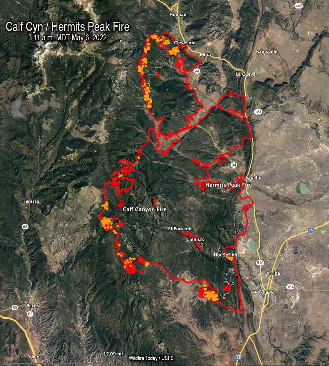
Map of the Calf Canyon / Hermits Peak Fire. The red line was the perimeter at 10:15 p.m. May 5. The white line was the perimeter two days before. The red and brown dots represent heat detected by satellites as late as 3:11 a.m. MDT May 6, 2022.
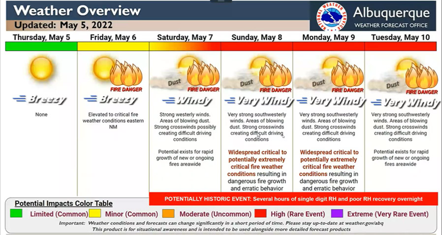
The weather is going to be a challenge again this weekend due to what firefighters call a “wind event”. According to the forecast Saturday will bring strong winds gusting to 39 mph, becoming even stronger on Sunday and Monday gusting to 45 mph. The direction will be generally out of the southwest and west while the minimum relative humidity each day hovers around 10 percent. These conditions will test the firelines on the east and northeast sides of the blaze. Firefighters, of course, are aware of the prediction and have been prepping structures, constructing and improving firelines, and building contingency lines further out.
A multi-day critical fire weather event will impact mainly New Mexico through the next few days, and also much of SE Colorado, eastern Arizona and the Texas panhandle/west TX. A combination of strong winds, low humidity, & warm temperatures can contribute to extreme fire behavior pic.twitter.com/u2mhxpK5FU
Over the last few days fire crews have been working north of the fire to be prepared if the fire makes a big run in that direction toward Chacon and Guadalupita South along the 519, 121, and 434 roads. Northeast and southeast of Mora they have used dozers to build firelines behind homes.
The Southwest Team #2 is bringing in a second team, a Type 2 team, Southwest Team #3. As explained by Operations Section Chief Todd Abel Friday morning, “They will integrate with our team. This means there’s still just one team, but we brought those people in to help us have a little bit more capacity so that if we have the potential to move further north that we have those folks available.”
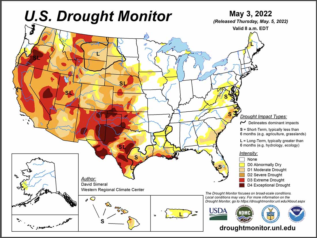
Most of New Mexico is in extreme or exceptional drought. The vegetation, or fuels, are atypically dry due to the drought, exacerbated by strong winds and high temperatures. Extremely dry fuels is one of the factors that can contribute to the rapid spread of a fire, especially when combined with very low humidity, high temperatures, and very strong winds.
The spread of the Calf Canyon / Hermits Peak Fire has been primarily through Ponderosa pine with a significant amount of dead and downed fuels in the understory. As the fire progresses downslope to the east, the dominant fuels transition through pinyon/juniper, Gambel oak, and brush to short grass.
CL-415 scooping air tanker supports a firing operation on the Calf Canyon & Hermits Peak Fire, New Mexico. May, 2022. IMT photo.
Map, Calf Canyon & Hermits Peak Fires at 4:38 a.m. MDT May 4, 2022.
Air tankers and helicopters assisting firefighters Tuesday provided an opportunity to engage aggressively on the ground. Structure protection, line construction and firing operations continued Wednesday.
The fire has grown to 160,104 acres and has destroyed 170 residences and 117 other structures.
To see all articles on Wildfire Today about the Calf Canyon and Hermits Peak Fires, including the most recent, click HERE.
Six Structure Protection Groups across the fire have been focusing on removing fuels, constructing line, and deploying other protection measures around homes and communities.
Map south side of Calf Canyon & Hermits Peak Fires at 4:38 a.m. MDT May 4, 2022.
Crews continue to conduct firing operations to remove fuel between containment lines and the uncontrolled fire edge to control portions of fire. One of the largest is on the south end of the fire west of Las Vegas. It began near the Bradner Reservoir and worked south past Luna Community College down to Highway 283, a distance of 5.3 miles.
Firefighters are removing fuel along the north side of Highway 283 in case the fire comes down that far. This will also facilitate using the highway to anchor a firing operation if needed to keep the fire north of the highway.
Map north side of Calf Canyon & Hermits Peak Fires at 4:38 a.m. MDT May 4, 2022.
On the north side of the fire a dozer line was constructed south of Cleveland and Mora from which crews burned out to help protect the communities.
The weather forecast for Thursday indicates that the wind speeds will be lower than they have been for several days, 17 mph out of the west-northwest with relative humidity in the low teens. Friday will be similar, with slightly stronger winds from the west. The strong winds will return Saturday through Tuesday, out of the west and southwest. The speeds will be in the high 20s gusting close to 40 mph with single digit humidity.
Aviation resources include large and very large air tankers, 14 helicopters, and six water-scooping air tankers. The scooper planes are obtaining water at Lake Isabel which is on private property.
Other resources on the fire include 104 engines and 23 hand crews for a total of 1,208 personnel.
In the video below a firefighter ignites a burning operation near Highway 283.
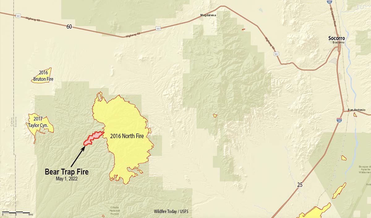
36 air miles west-southwest of Socorro, New Mexico
Updated at 7 p.m. MDT May 2, 2022
Map Bear Trap Fire May 1, 2022.
At noon on Sunday May 1 the Bear Trap Fire started in Bear Trap Canyon in the Cibola National Forest 36 air miles west-southwest of Socorro, New Mexico. At about 4 p.m. the Southwest Coordination Center tweeted that nine air tankers were working the fire — three Very Large Air Tankers (DC-10s) and six Large Air Tankers — plus four Air Tactical aircraft, a Type 3 Incident Management Team, one hand crew, and eight fire engines. That was an aggressive initial attack.
@VentanaRanch who was using an app to monitor the aircraft at the fire, Tweeted at 4:28 p.m., “Non-stop tankers from [Albuquerque] and Silver City.”
On Monday officials said the blaze had burned 1,209 acres. The fire behavior was described as moderate with isolated torching as it spread through pine, pinyon-juniper, and grass.
At 3 p.m. on Sunday the Magdalena weather station not too far from the fire recorded 10 mph winds out of the southwest gusting to 26, with 5 percent relative humidity. The weather forecast for the fire area on Tuesday calls for 25 mph winds out of the southwest gusting to 36 mph with 11 percent relative humidity. Similar conditions are predicted for Wednesday.
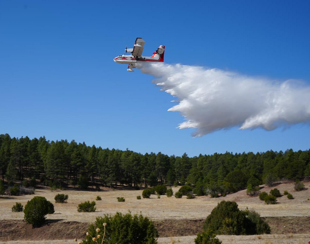
An air tanker drops on the Bear Trap Fire, San Mateo Mountains, New Mexico, May 1, 2022; . FS Photo by S. Matt Counts, Cibola NF, and Air Attack.
By Sunday night, based on a rough map of the perimeter, the head of the fire appears to have burned into the footprint of the North Fire which burned 42,000 acres in May of 2016. That fire was not fully suppressed, but the strategy of the Bear Trap fire is full suppression.
With about half a dozen other fires in Arizona and New Mexico, some of them very large, the Type 3 Incident Management Team which will assume command at 6 a.m. Tuesday may run into difficulty competing for firefighting resources.The teams on the Calf Canyon / Hermits Peak Fire and the Cerro Pelado Fire have listed as critically needed resources a total of 8 hand crews and 20 engines.
Bear Trap Fire, New Mexico, May 2, 2022; San Mateo Mountains. FS Photo by- S. Matt Counts, Cibola NF and Air Attack.