Map of the Calf Canyon / Hermits Peak Fire. The bright red dots represent heat detected by a satellite at 3:49 a.m. MDT May 20, 2022.
The four largest active wildfires in New Mexico all continued to grow Thursday and have burned a total of more than 476,000 acres. Red Flag Warnings are in effect Friday for winds gusting from 30 to 40 mph with single digit humidity.
The 303,701-acre Calf Canyon / Hermits Peak Fire northwest of Las Vegas was subject to single digit humidity and strong winds Thursday afternoon, 10 to 20 mph with 30 to 40 mph gusts out of the west. Since the east side is somewhat secure most of the additional spread was limited to the west side, which experienced in some areas fire behavior described as “extreme, crowning, group torching, and spotting.”
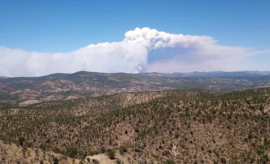
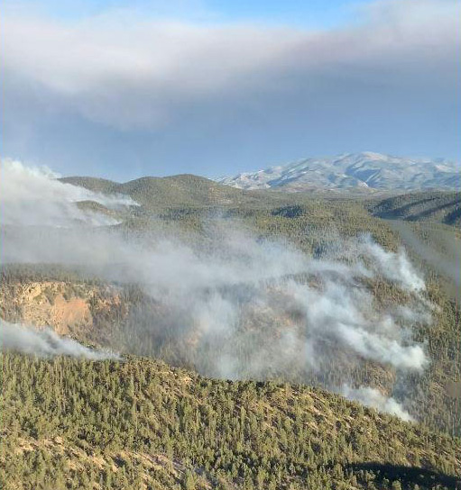
Smoke over the Calf Canyon – Hermits Peak Fire May 18, 2022 by pilot Travis Graham.
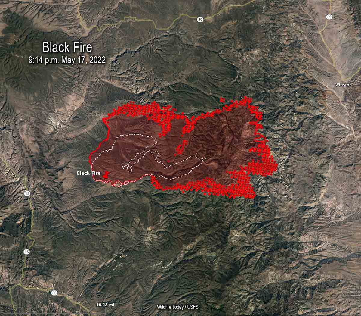
The Black Fire 28 miles west-northwest of Truth or Consequences consumed more vegetation on the northwest, northeast, east, and southeast sides. Fire officials said in some places it spread for three miles, growing on the southeast side to within one or two miles of Hermosa. It has burned 104,969 acres.
Map of the Black Fire. The bright red dots represent heat detected by a satellite at 3:49 a.m. MDT May 20, 2022.
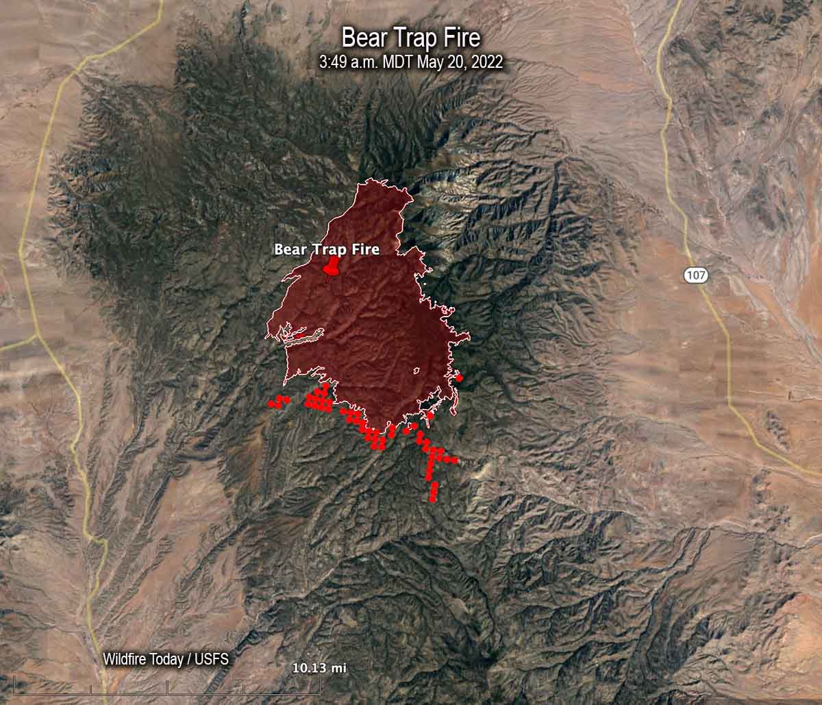
Most of the spread of the 21,687-acre Bear Trap Fire 34 miles southwest of Socorro was on the south side Thursday. Hand crews are prepping and conducting tactical burning operations, some of which may be conducted by aerial ignition. Limited movement to the east off the San Mateo crest is expected due to non-continuous fuels in several recent fire scars.
Map of the Bear Trap Fire. The bright red dots represent heat detected by a satellite at 3:49 a.m. MDT May 20, 2022.
The 45,605-acre Cerro Pelado Fire six miles southwest of Los Alamos has been relatively quiet for several days.
Red Flag Warning for the Calf Canyon / Hermits Peak Fire, May 19-20, 2022. NWS.
The National Weather Service has taken the unusual step of issuing a Red Flag Warning one and two days in advance for the Calf Canyon / Hermits Peak Fire 21 miles east of Santa Fe, New Mexico. The prediction is for winds gusting from the west and southwest at more than 30 mph with single digit relative humidity. Similar conditions will exist at least on Thursday for the area of the Black and Bear Trap Fires in southwest New Mexico.
Updated 12:10 p.m. MDT May 18, 2022
Map of the Black Fire. The bright red dots represent heat detected by a satellite at 2:48 a.m. May 18. The red line is the perimeter at 9:14 p.m. May 17. The white line is the perimeter about 48 hours before.
On Wednesday the northern half of New Mexico is under a Red Flag Warning. Isolated dry thunderstorms are predicted for portions of New Mexico, Texas, and Colorado.
Red Flag Warnings Wednesday.
Chance for isolated dry thunderstorms in portions of NM, CO, & TX.
From the NWS:
“Thunderstorms are expected across portions of the central Rockies this afternoon. Storms should be dry with the potential for new lightning induced fire starts.” pic.twitter.com/kT4KwlJC27
The Calf Canyon – Hermits Peak Fire 21 miles east of Santa Fe, NM was active on the west side Tuesday, but there was very little significant activity on the east side between Mora and Las Vegas.
The Cerro Pelado Fire 25 miles west of Santa Fe was relatively quiet Tuesday. There has been no major spread for several days and a satellite was only able to detect one large heat source early Wednesday morning.
Black Fire, May 16, 2022. IMT photo.
The Black Fire (see map above) 28 miles west-northwest of Truth or Consequences made another large run to the east Tuesday adding another 21,000 acres to bring the total up to 77,360. Fuel treatments and wildfires that have occurred over the last 20 years may slow any major spread to the north, west, and south, but the NIFC database shows no significant history of fire east of the incident.
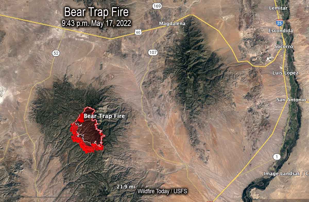
Map of the Bear Trap Fire. The bright red dots represent heat detected by a satellite at 2:48 a.m. May 18. The red line is the perimeter at 9:43 p.m. May 17. The white line is the perimeter about 24 hours before.
Another fire in southwest New Mexico, the Bear Trap Fire, is 34 miles southwest of Socorro. It spread southwest on Tuesday and was mapped Tuesday night at 15,215 acres. The fire is surrounded by fuel treatments and prescribed natural fires on all sides except for the southwest — which is where the most of the spread has occurred during the last couple of days.
South side of the Bear Trap Fire, May 16. IMT photo.
5:10 p.m. MDT May 17, 2022
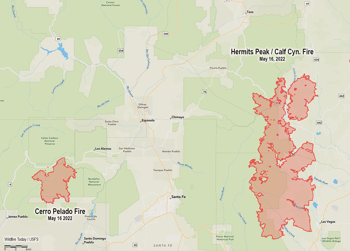
Map showing the location of the Cerro Pelado and Calf Canyon – Hermits Peak Fires, the evening of May 16, 2022.
High temperatures and very low humidity on Tuesday kept most of the large wildfires in New Mexico very active.
Calf Canyon – Hermits Peak Fire
The Calf Canyon – Hermits Peak Fire 21 miles east of Santa Fe has become the largest fire in the recorded history of New Mexico. At 299,565 acres it has eclipsed the previous record set by the 297,845-acre Whitewater and Baldy Fires when they burned together in May of 2012 in Southwest New Mexico. On Tuesday it was again putting up a large smoke column while a 5 to 20 mph wind gusted out of of the northwest, west, and southwest at 25 mph. The humidity dropped to 10 percent in the afternoon.
Cerro Pelado Fire
On Monday most of the fire activity on the 45,605-acre Cerro Pelado Fire was on the northwest and southeast sides. On Tuesday the fire 25 miles west of Santa Fe was putting up much less smoke than the Calf Canyon – Hermits Peak Fire, judging from the Satellite photo below taken at 3:56 p.m.
36 air miles west-southwest of Socorro, New Mexico
Updated at 7 p.m. MDT May 2, 2022
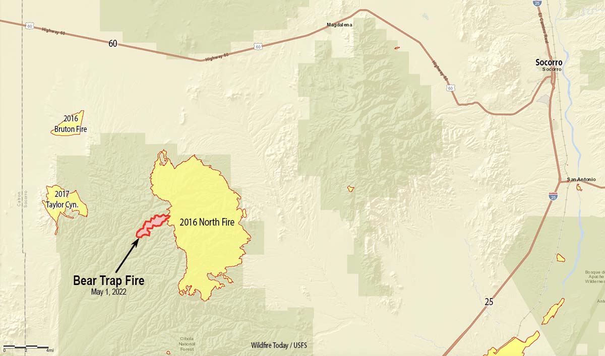
Map Bear Trap Fire May 1, 2022.
At noon on Sunday May 1 the Bear Trap Fire started in Bear Trap Canyon in the Cibola National Forest 36 air miles west-southwest of Socorro, New Mexico. At about 4 p.m. the Southwest Coordination Center tweeted that nine air tankers were working the fire — three Very Large Air Tankers (DC-10s) and six Large Air Tankers — plus four Air Tactical aircraft, a Type 3 Incident Management Team, one hand crew, and eight fire engines. That was an aggressive initial attack.
@VentanaRanch who was using an app to monitor the aircraft at the fire, Tweeted at 4:28 p.m., “Non-stop tankers from [Albuquerque] and Silver City.”
On Monday officials said the blaze had burned 1,209 acres. The fire behavior was described as moderate with isolated torching as it spread through pine, pinyon-juniper, and grass.
At 3 p.m. on Sunday the Magdalena weather station not too far from the fire recorded 10 mph winds out of the southwest gusting to 26, with 5 percent relative humidity. The weather forecast for the fire area on Tuesday calls for 25 mph winds out of the southwest gusting to 36 mph with 11 percent relative humidity. Similar conditions are predicted for Wednesday.
An air tanker drops on the Bear Trap Fire, San Mateo Mountains, New Mexico, May 1, 2022; . FS Photo by S. Matt Counts, Cibola NF, and Air Attack.
By Sunday night, based on a rough map of the perimeter, the head of the fire appears to have burned into the footprint of the North Fire which burned 42,000 acres in May of 2016. That fire was not fully suppressed, but the strategy of the Bear Trap fire is full suppression.
With about half a dozen other fires in Arizona and New Mexico, some of them very large, the Type 3 Incident Management Team which will assume command at 6 a.m. Tuesday may run into difficulty competing for firefighting resources.The teams on the Calf Canyon / Hermits Peak Fire and the Cerro Pelado Fire have listed as critically needed resources a total of 8 hand crews and 20 engines.
Bear Trap Fire, New Mexico, May 2, 2022; San Mateo Mountains. FS Photo by- S. Matt Counts, Cibola NF and Air Attack.