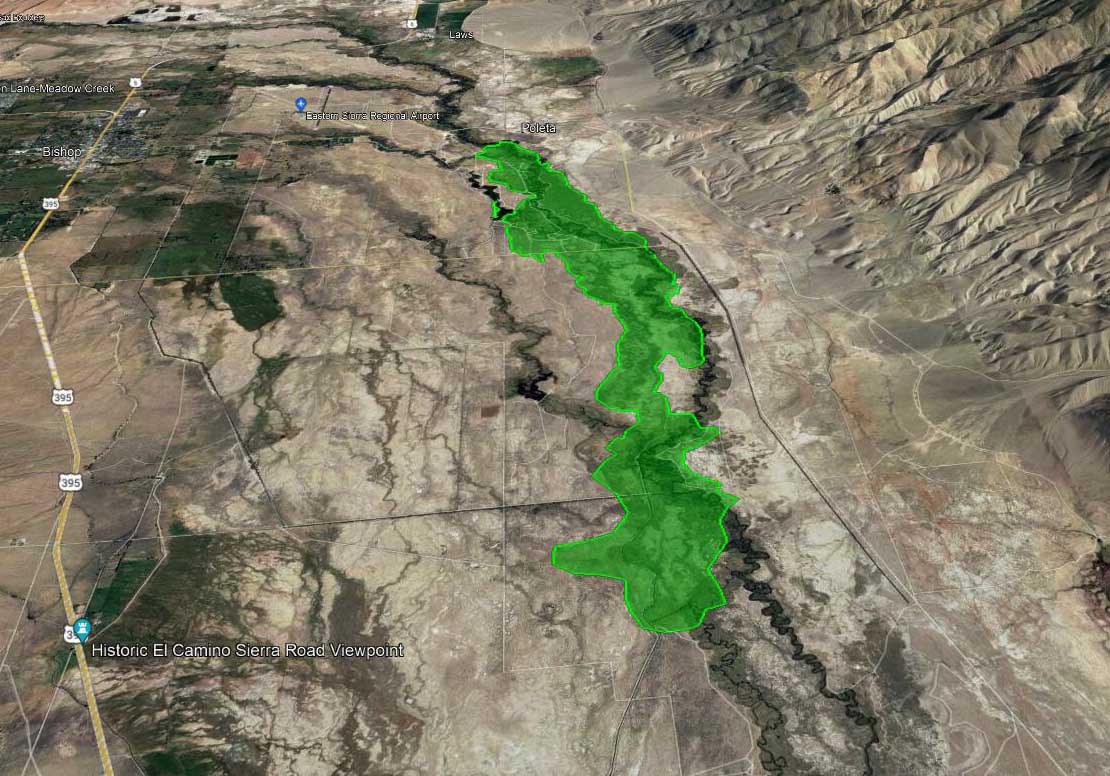
Map, Airport Fire at approximately 5 p.m. Feb. 16, 2022, looking north. By FIRIS aircraft, via Muni-Captain.
A fire in the northern end of California’s Owens Valley has burned about 2,156 acres, according to the FIRIS mapping aircraft at 4:45 p.m. PT Wednesday.
The incident is three miles east of Bishop and one mile southeast of the Eastern Sierra Regional Airport. Aircraft are having difficulty flying safely and dropping retardant accurately in the very strong winds gusting out of the north at 28 mph gusting at 32 to 50 mph while the relative humidity is 30 percent.
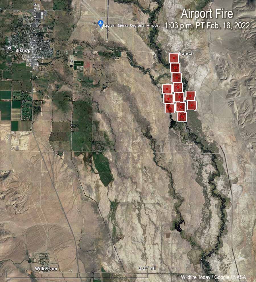
Map, Airport Fire, heat detected by satellite at 1:03 p.m. Feb. 16, 2022.
The wind is pushing it to the south. The CHP reports it has crossed Collins Road, which is five miles south of Bishop.
CAL FIRE reported at 5:38 p.m. that the town of Big Pine is being evacuated. The agency said the evacuation center is at the Bishop Senior Center, 506 Park Ave., in Bishop.
Airport Fire, posted by CAL FIRE BDU at 4:54 p.m. Feb. 16, 2022.
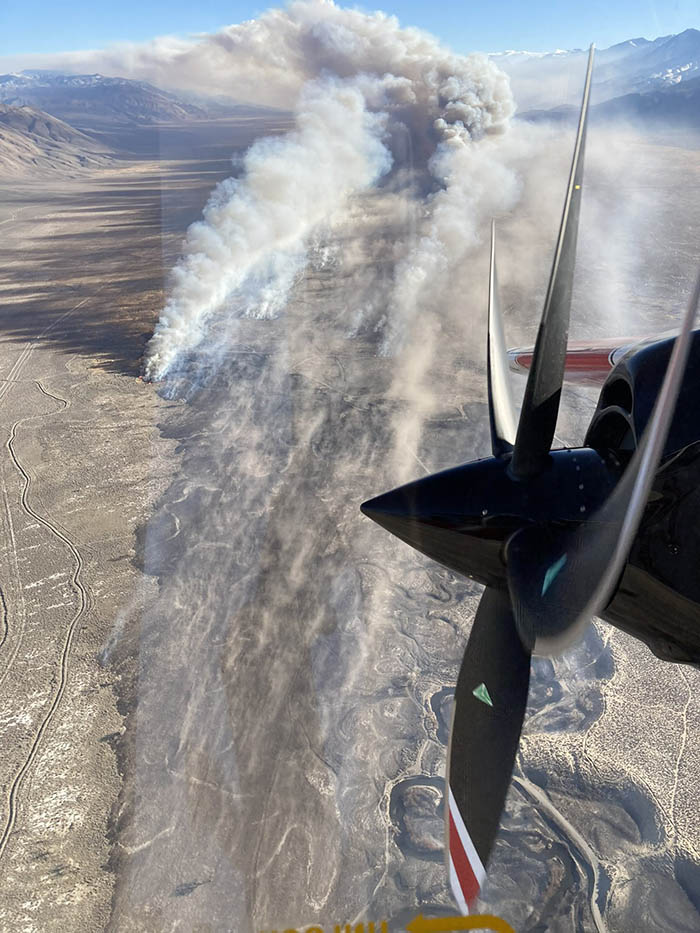
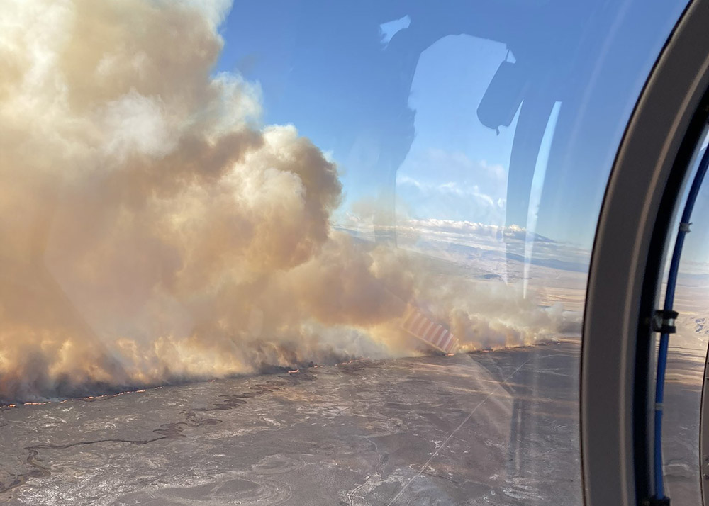
Below is video, visual and infrared, of the Airport Fire southeast of Bishop, California at 4 p.m. PT Feb. 16, 2022. Shot by the Orange County FIRIS aircraft, Intel 12. When in infrared mode, the bright white areas represent heat from the fire.
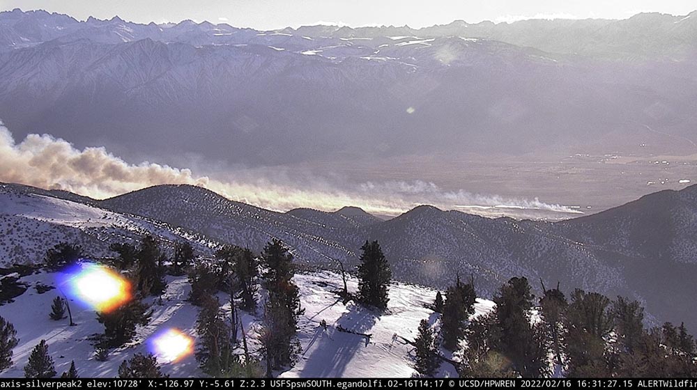
Airport Fire, posted by CAL FIRE BDU at 4:54 p.m. Feb. 16, 2022.Airport Fire, as seen from the Silverpeak 2 camera at 4:31 p.m. Feb. 16, 2022.
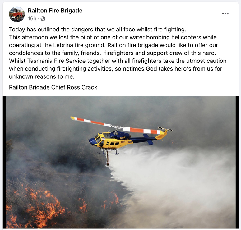
A pilot was killed in Australia February 14 when a helicopter crashed while working on a bush fire southeast of Pipers Brook, Tasmania. The accident was reported to the police and emergency services at about 3:20 p.m. The pilot was the only person on board.
From the Australian Broadcasting Corporation:
Tasmania Fire Service Acting Deputy Chief Jeff Harper said the northern Tasmanian man was an experienced pilot who had been assisting water-bombing activities as a subcontractor.
Mr. Harper said it was a tragic incident, and that the man had worked on multiple Tasmanian fires in the past.
Firefighting aircraft were grounded after the helicopter crash, and will all be assessed overnight before being deployed again.
The Tasmania Police said the pilot’s next of kin has been notified.
Since it started several days ago the fire has burned 1,660Ha (4,100 acres). Helicopters, fixed wing aircraft, heavy machinery, and firefighters on the ground have been working to control the blaze. A number of forestry plantations have been impacted and one structure has been destroyed.
The ABC reported that the bushfire had resulted from a registered burn that got away from the “very remorseful” owner, and it had been deemed accidental.
The Tasmania Police is asking that anyone with information who may have seen the helicopter near Pipers Brook just before the crash should call Launceston Police on 131444 or report it to Crime Stoppers on 1800333000 or crimestopperstas.com.au. Information can be provided anonymously.
On January 23, 2020 the three crewmembers of an EC-130Q, Air Tanker 134, were killed when the aircraft crashed while working on a fire in New South Wales.
Fire Aviation sends out our sincere condolences to the family, friends, and coworkers of the deceased pilot.
The make and model of the helicopter has not been released.
Wildfire in Mississippi burned more than 1,000 acres
Red Flag Warnings issued by the NWS, Feb. 14, 2022.
The National Weather Service has issued Red Flag Warnings for Monday February 14 for areas in New Mexico, Kansas, Missouri, Arkansas, Louisiana, Mississippi, and Florida.
It is not common to see Red Flag Warnings in Arkansas, Louisiana, Mississippi. Take a look at the video below posted today of a fire in northeast Mississippi that burned 1,041 acres; it’s a very interesting burn pattern.
#MSforestry Commission Wildland Firefighters suppressed and contained this giant 1041-acre #wildfire in Tippah County. The fire, located in Tiplersville, MS, damaged pasture and woods.
As we head into our wildfire season here in MS, please be extra cautious with outdoor burning. pic.twitter.com/7hq31JJkRS
I checked with Tyler Thomas who is an Area Forester for the Mississippi Forestry Commission (MFC) who told us the fire occurred January 31 and February 1. In addition to the personnel from local fire departments, the MFC had five firefighters on it which included two dozers with swampers. When they arrived it had already burned about 1,000 acres and when the spread was stopped it was about three miles long.
I mentioned to Mr. Thomas what looked like in the aircraft video an unusual burn pattern, but he said it was all one fire and there was no major spotting out ahead of the main fire.
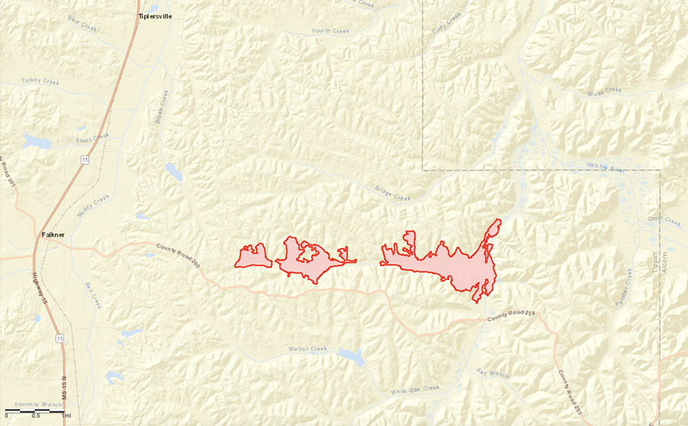
UPDATE Feb 19, 2022: The map below shows the estimated perimeter of the fire in NE Mississippi, based on imagery. The fire was named, 1686 County Road 202 Fire.
Fire in NE Mississippi, estimated perimeter Feb. 1, 2022.
The blaze burned 154 acres, coming very close to homes
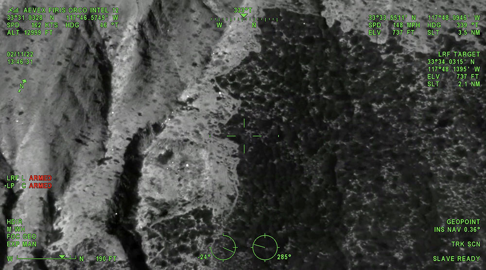
Still image from the video below of the Emerald Fire, from the FIRIS mapping aircraft at 1:46 p.m. PT Feb. 11, 2022.
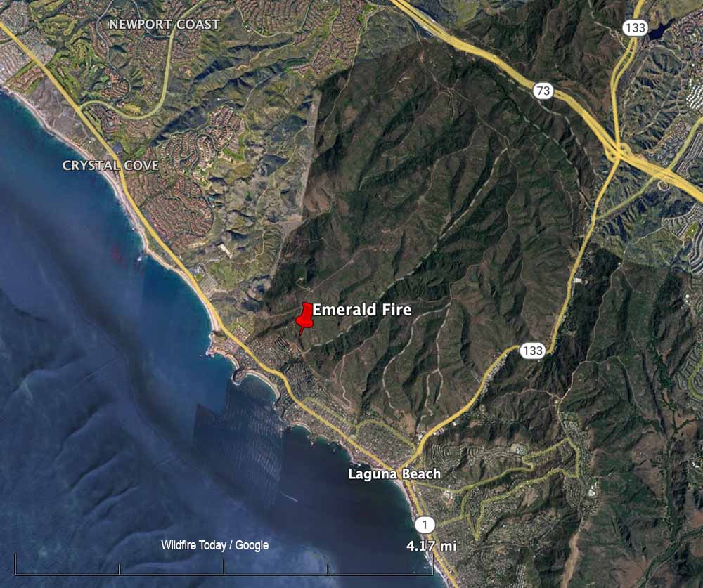
The Emerald Fire near Laguna Beach, California was mapped by the Fire Integrated Real-Time Intelligence System (FIRIS) aircraft. The video below was recorded at 1:45 p.m. February 11, day two of the fire. The image switches back and forth from thermal infrared to regular video, with heat showing up as bright white. This data can help firefighters know where to concentrate their containment and mop up efforts.
After the fire was reported Feb. 10, 2022 at about 4 a.m. in the Laguna Coast Wilderness Area, strong winds pushed the blaze near homes in the Emerald Bay area of the coastal city. It ultimately burned 154 acres, coming very close to homes, as you can see in the video.
In the aircraft were Peter Cain (Pilot), Matt Hedman of AEVEX on the controller, and Air Tactical Group Supervisor Steve Price providing narration.
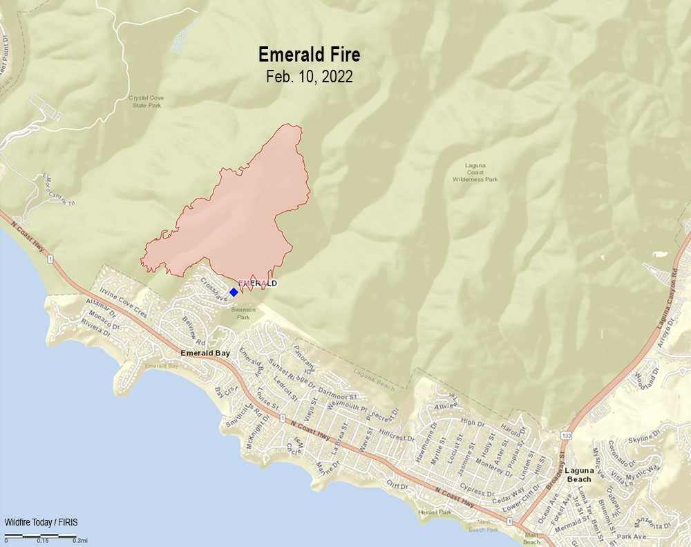
Map Emerald Fire, Feb. 10, 2022.Map showing the location of the Emerald Fire near Laguna Beach in Southern California, Feb. 10, 2022.
The Terrace Fire is near Monte Rio, northwest of Santa Rosa
10:31 a.m. PST Feb. 11, 2022
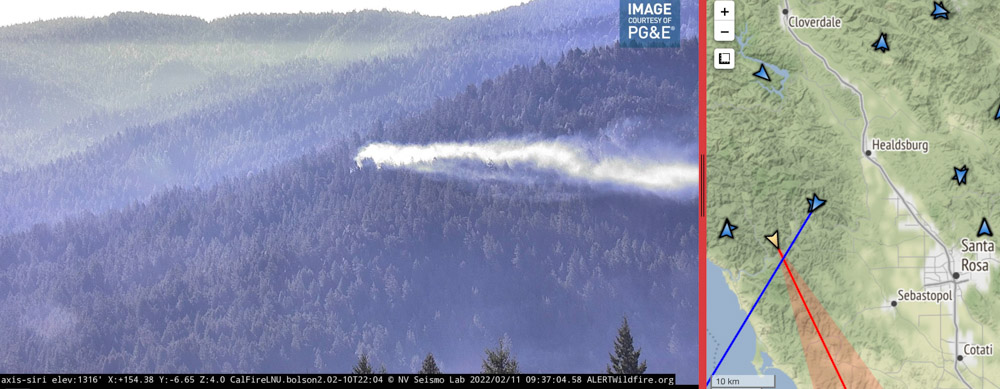
Using its spotlight, Sonoma County Sheriff’s Office helicopter Henry 1 directs firefighters to a fire near Monte Rio in Northern California. As seen from the Alert Wildfire camera at Siri, in infrared mode at 10:32 p.m PT Feb. 10, 2022.
Firefighters in Northern California had assistance from a Sonoma County Sheriff’s helicopter Thursday night as they were finding the best route to hike to the Terrace Fire near Monte Rio. It was reported at about 9 p.m. on a slope above Highway 116. The helicopter known as Henry 1 used its spotlight to direct the personnel as they hiked through the densely forested area.
When crews reached the blaze at about 11 p.m. they reported it had burned about one acre. Friday morning the Alert Wildfire camera at Siri showed that it is still generating a fair amount of smoke which is being blown close to the ground by the wind.
Image of smoke from a fire in Sonoma County near Monte Rio as seen from the Alert Wildfire camera at Siri, 9:37 a.m. PT Feb. 11, 2022. The intersection of the lines from the two camera locations indicate the approximate location of the fire.
The fire is about 14 miles west-northwest of Santa Rosa.
The Press Democrat reported Friday morning that Stephane Lunsford, a public information officer for CAL FIRE, said crews had completed a line around 85 percent of the fire.
Kent Porter (@kentphotos) shot some very interesting photos Thursday night. Here are a couple. Click on them twice to see larger versions:
Extremely tough access for fire crews Thurs. in a heavily forested area of Monte Rio, so @sonomasheriff Henry 1 illuminated the way for firefighters (it’s a walk in show to put the fire out). This is one of those times I backed off and looked for the artsy moment. @NorthBayNewspic.twitter.com/zjLYcZUYuG
A one-acre fire is not huge news. We don’t often hear about fires like this. But it’s an example of how firefighters are usually successful in keeping fires small, even when it requires hiking for hours at night through dense woods to find and then put out a fire.
In addition, it’s a fire in early February, far outside the traditional fire season in Northern California. But also the images are fascinating — the infrared photo showing the spotlight from the helicopter, smoke from the fire the next morning, and especially the great photos taken by Mr. Porter.
Hundreds of residents were evacuated before dawn Thursday
Updated at 10:08 p.m. PT Feb. 10, 2022
Map Emerald Fire, Feb. 10, 2022.
Thursday morning firefighters stopped the spread of the 145-acre Emerald Fire northwest of Laguna Beach in Southern California. At the peak of activity there were 220 personnel assigned, plus numerous helicopters and fixed wing aircraft.
All of the evacuation orders were lifted at 3 p.m. and no structures were destroyed. Areas in the interior of the fire are still burning, fire officials said Thursday afternoon, and the predicted hot, dry weather means they will have to continue to monitor, mop up, and improve containment.
The last time the area burned was during the Laguna Fire of 1993 which covered 14,337 acres, enveloping almost the entirety of Crystal Cove State Park and Laguna Coast Wilderness Area.
A spokesperson for the fire said good clearance of vegetation around the homes made it much easier for firefighters to prevent any structures from burning.
Fire personnel will be on scene Thursday night and fresh troops will arrive Friday morning.
1:04 p.m. PT Feb. 10, 2022
Map showing the location of the Emerald Fire near Laguna Beach in Southern California, Feb. 10, 2022.
Evacuation orders for the Emerald Fire prompted hundreds of residents in Laguna Beach in Orange County, California to leave their homes before dawn Thursday. Reported at about 4 a.m. in the Laguna Coast Wilderness Area, strong winds pushed the blaze near homes in the Emerald Bay in the coastal city.
As the fire was spreading, a weather station at Moro Canyon recorded 15 to 22 mph winds gusting out of the north-northeast up to 43 mph while the relative humidity was 31 percent. Those conditions are conducive to rapid fire spread and would have pushed the fire to the south-southwest. When the winds subsided later in the morning firefighters were able to stop the spread. Preliminary estimates put the size at about 140 acres, but that could change with more accurate mapping.
“We no longer have a fire season. We have a fire year,” said Orange County Fire Authority Chief Brian Fennessy in a news conference Thursday morning. “It’s February 10. This is supposed to be the middle of winter and we’re anticipating 80 to 90 degree weather. Even though the hillsides are green it doesn’t take but low humidity and wind to cause fires to occur. If this is any sign of what’s to come throughout the rest of the winter and spring we’re in for a long year.”
Two weather advisories are in effect for much of Southern California on Thursday, including the Emerald Fire area; one is for wind and another for heat. The forecast for the Laguna Beach area for Thursday morning called for northeast winds of 15 to 25 mph with gusts to 45. The heat advisory predicted high afternoon temperatures of 91 degrees.