It burned over 6,000 acres and nearly 1,100 homes northwest of Denver, December 30, 2021
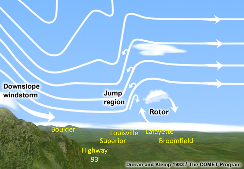
Conceptual model of a mountain wave. NWS.
The Denver office of the National Weather Service has released an analysis of the weather that created the conditions on December 30, 2021 that allowed the Marshall Fire southeast of Boulder, Colorado to be turned into a blast furnace that within a few hours ran five miles to the east burning 6,000 acres and destroying nearly 1,100 homes with a total value of more than $500 million.
The NWS described the winds the day of the fire:
High winds developed in the mid morning hours on Thursday, December 30th, 2021, the result of a mountain wave that developed as very strong westerly winds raced over the Front Range Mountains and Foothills and crashed down onto the plains. The mountain wave remained nearly unchanged through the rest of the day, resulting in very persistent and extremely high winds. Mountain waves are usually focused very close to the base of the foothills and adjacent plains. On this day, sustained winds of 50 to 60 mph with gusts of 80 to 100 mph were felt along Highway 93 and points east to around Superior and at times, Louisville.
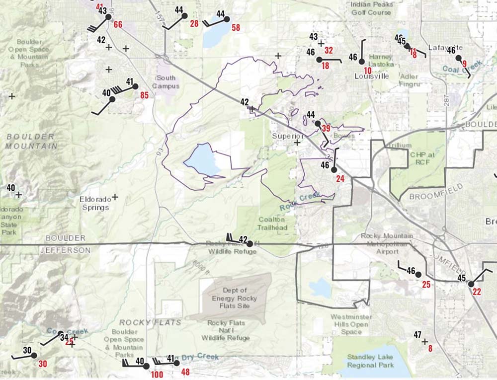
On the map below, the final fire perimeter is outlined by light purple (upper center of the plot images), while the city of Boulder is located in the northwest corner. The black numbers are temperature (F), red numbers are wind gusts, and the wind barbs point to the direction the wind was from.
Wind gusts (in red), temperatures (in black) at noon, Dec. 30, 2021, Marshall Fire, NWS.
The surface plot for 12 PM MST above shows some of the strongest winds from this wind event. A peak gust of 115 mph was reported at the base of the foothills, just east of the intersection of Highway 93 and Highway 72. Note the 85 mph gust in south Boulder, and a 100 mph gust along Highway 93 (very bottom of the image below) at about noon.
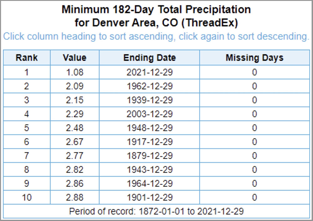
Precipitation in the Denver area, 6 months before Marshall Fire, compared to previous dry periods. NWS.
After a very wet first half of the year that resulted in a lush, tall crop of grass, the six months leading up to the fire in late December were the driest in recorded history, by far. Drought affects moisture in the vegetation — the fuel moisture. The lower is it, the more easily and more intensely it burns in a wildfire. There were many areas in the fire with light vegetation, such as grass, that in December after it has cured would be more affected by recent rain (or the lack thereof) and relative humidity than long term drought. The relative humidity was in the mid-20s that day. But the National Weather Service said larger fuels such as shrubs and trees were plentiful in and around the affected subdivisions. Those fuels would be heavily affected by the historic drought and would have low fuel moistures in the live and dead vegetation.
Drought can also affect the home ignition zone. If gutters on homes are not kept clean of leaves, they can be ignited during an ember shower even if the fire is thousands of feet away. If the gutters have leaves during normal weather, especially in December near Boulder, they could also have water that is trapped by the leaves keeping them wet for weeks or months. But with historic drought, it is possible the water evaporated, making them susceptible for ignition by embers. A fire in a gutter can spread to the structure.
The lawns that in late December would often be covered by snow, were most likely brown and dry, making it possible for an ember to ignite the grass which could spread to homes. Mulch, such as bark or wood chips placed around ornamental plants and near structures would also be much drier than normal, making that fuel available. And remember, the winds were 50 to 60 mph with gusts of 80 to 100 mph.
As structures burned, millions of additional burning embers were lofted into the air with many of them igniting susceptible fuels out in front of the main fire. A burning home that in many cases was only 15 to 20 feet away from other houses could easily ignite through convective or radiant heat the neighboring residence.
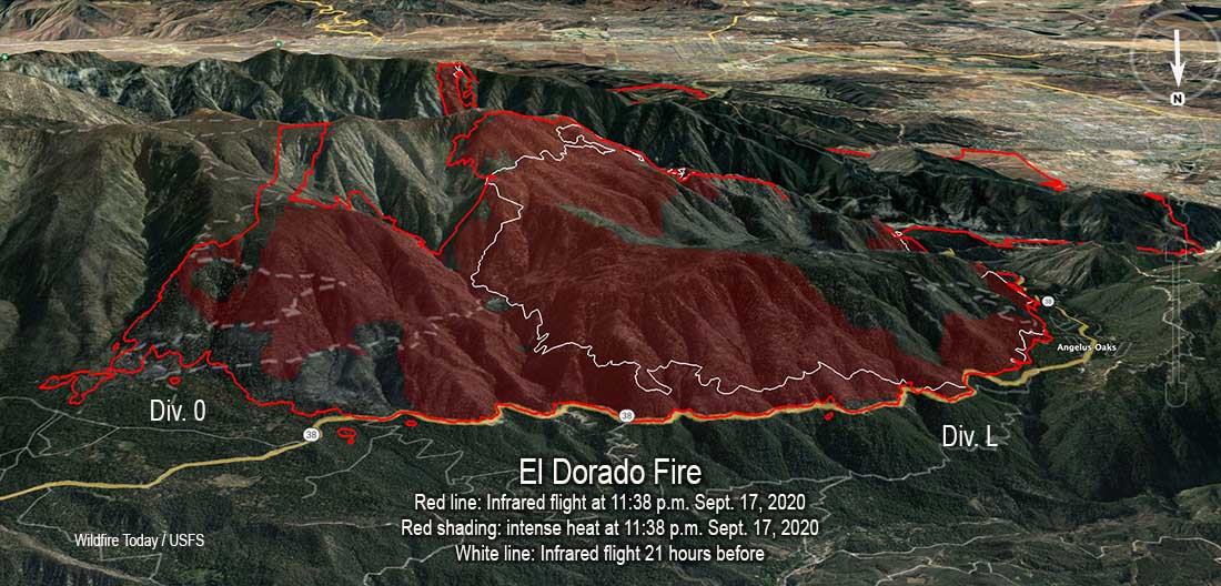
3-D map of the north side of the El Dorado Fire, from infrared flight, 11:38 p.m. Sept. 17, 2020. Looking south.
About 15 months afterCharles ‘Charlie’ Morton was fatally burned on the El Dorado Fire on the San Bernardino National Forest in Southern California, the US Forest Service released a series of reports about the incident.
According to one of the documents, titled Narrative, Charlie, a squad leader on the Big Bear Interagency Hotshot Crew was scouting the fire alone around 7 p.m. September 17, 2020 when it overran his location. Crews had just stopped igniting a burnout. As the fire intensity increased, one of the crew captains asked him on the radio if he was going to be able to get out of the area. Charlie’s response was, “We’ll see.” Following that, the Captain called him several times with no response. He then heard Charlie call in desperation, “I’m in a corner.” It was the last time he transmitted on the radio.
Due to extreme fire behavior, including counter-rotating vortex pairs that formed at his exact location as a result of the burnout operation underway, it was hours before anyone could access Charlie’s location. During that time he was assumed to be missing and the Operations Section Chief assigned the Contingency Branch Director as the Incident-Within-an-Incident Commander to lead the search.
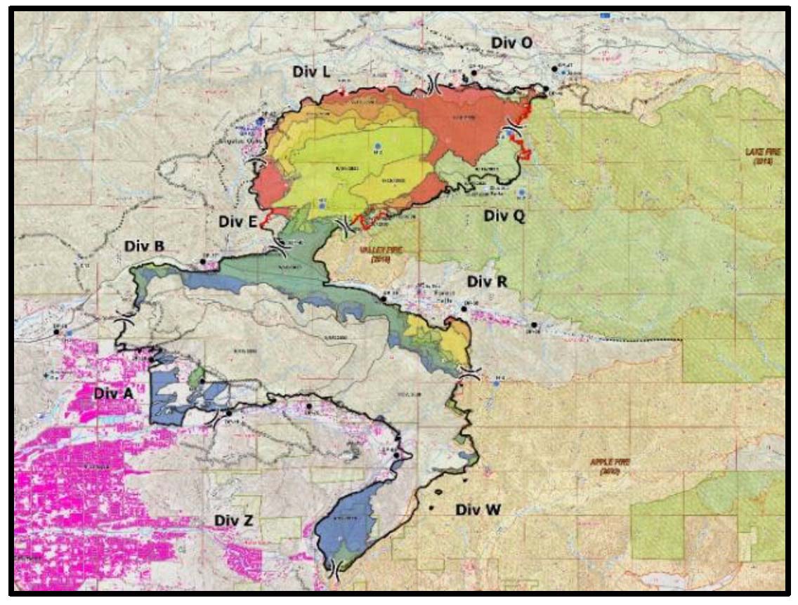
El Dorado Fire Progression map for September 5 to 17, 2020. The report covers activity in Divisions L and O.
For nearly two hours a sheriff’s helicopter utilized their loudspeaker to call out “If you are a lost hotshot firefighter, give us a signal. If you are a lost hotshot firefighter, give us a signal.” At that time firefighters were very busy attempting to suppress numerous spot fires. Some of them were not aware of the missing firefighter when they heard the announcement from the helicopter.
From the Learning Review Narrative, about the beginning of the search:
BR 5 [Branch Director 5] tried to gain access to the bulldozer line from the Camp Round Meadow area and was accompanied by Division L Medic. Although the medic had limited wildland fire experience, it was apparent that the situation was dangerous. He noted falling snags, extreme temperatures, and that fire flanking below them could cut off their egress back to Camp Round Meadow. He thought he was going to die in there and sent a pin of his location to the Division O Medic so that someone could locate Division L Medic if something bad happened.
Meanwhile, SBC Type 2 Initial Attack Crew tied in with Branch and was allowed to fly a small [CAL FIRE] drone equipped with an infrared camera down the bulldozer line to assist with the search. Drone footage showed significant heat along the line which rendered the infrared camera useless. They switched camera modes and flew a few more missions searching various areas.
The conditions were so dangerous that the Safety Officer decided to call off the ground search.
The time of day or night was not mentioned very often in the report, but some time later:
Big Bear captain 1B (who was filling the role of DIVS L trainee) arrived and announced that he was going to search at the bottom of the bulldozer line. BC#1 [Battalion Chief] didn’t want him to go into the area alone, so he decided to join. Big Bear Captain 1B searched the right side of the bulldozer line and BC#1 searched the left. Even with their big flashlights, it was difficult to see through the darkness, smoke, and flames. A quick reflection of light from an accordioned and undeployed fire shelter caught BC#1’s eye on the edge of the bulldozer line near a bend. They stopped 25 feet away and were able to determine that Charlie had not survived.
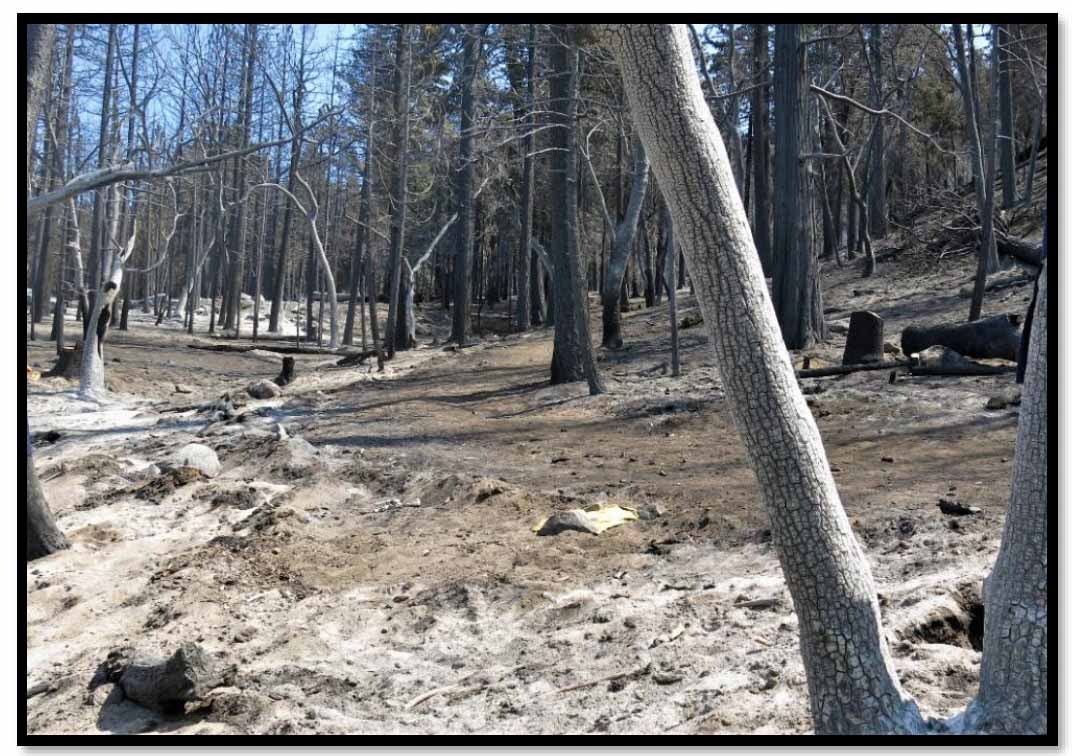
The yellow shirt marks the September 17, 2020 fatality site at the El Dorado Fire. From the report.
The area was still very hot and smoky, and the captain and BC#1 returned to the road below. A medic suggested that she could go to the scene to pronounce Charlie’s time of death, but the decision was made that it was too dangerous. The Safety Officer inserted guards at the bottom of the bulldozer line to keep people from going to view the scene and to prevent another fatality.
At the bottom of the bulldozer line, BR V blew past the guards and went up to the site to be with Charlie and stayed there with him. Some people said to just let him go, but after a period time people began to assume that BR V was fatally lost as well. A second search was organized for BR V. Searchers were unable to access the site due to the heat and falling trees. For approximately a two-hour period, nobody was able to reach BR V because his radio and his cell phone were left in the pickup. Division O Medic returned to stage at DP 45, now waiting to render aid if needed. About 0145, BR V returned down the hill and notifications were passed that he was safe. BR V came down the hill as soon as he realized he’d left his communication devices in his truck.
Charlie is survived by his fiancée, a daughter, parents, and two brothers.
The fire began at 10:23 a.m. September 5, 2020 in the El Dorado Ranch Park in Yucaipa. It was caused by the use of a smoke generating pyrotechnic device. The intent was to produce pink or blue smoke to inform bystanders about the gender of a fetus. A couple was charged with involuntary manslaughter and 29 other crimes.
Other reports
The information above came from the Narrative, a 29-page document that unlike recent facilitated learning analysis (FLA) documents, only covers the very, very detailed chronological facts of what happened on September 17 on the north side of the El Dorado Fire. It does not address, like the FLA for the Cameron Peak Fire for example, 250 Lessons Learned broken down into 14 types of resources (e.g. Finance Unit, Contractors) and 7 categories (e.g. COVID mitigations and testing/contact tracing).
But two other documents were also released about the fatality:
The latter, the Organization Learning Report, breaks with recent established practices, as the Narrative did.
It does not drill down into minutia of what occurred on the El Dorado Fire. It looks at it from 30,000 feet and extrapolates the significance on a much broader scale about the current state of wildland fire management.
It was led by Bill Avey who was appointed to the position of acting director for Fire and Aviation Management in Washington for five months in 2021. He retired December 31, 2021 as the Forest Supervisor of the Helena-Lewis and Clark National Forest in Montana.
Below are excerpts from the seven-page Organization Learning Report. It appears that much of the information came from interviews — not all of the topics are covered in the Narrative. For example, it suggests that perhaps firefighters (or forestry technicians) should be called “fire responders” so they don’t “view fire as an enemy.” Other than that many of their conclusions are very reasonable, even though most of them have been previously identified in various forms. But having so many of them listed in one fatality report is unique, and could be useful. Unless it just disappears into files like so many others.
In his September 24, 2020 testimony before Congress, John Phipps, the Forest Service’s Deputy Chief of State and Private Forestry, stated “the system is not designed for this,” to illustrate the misalignment between the design of the wildland fire system and the reality that wildland fire responders routinely experience.
…
The El Dorado Fire burned as an area ignition resulting from high accumulations of long-burning fuel materials present in the unhealthy forest conditions at the time of the fire. This type of fire behavior was once rarely seen among our wildland fire responders but is becoming increasingly more common because of the current condition of our forests and the influences of climate change. Our current paradigm of treating fire as an enemy that must be defeated contributed to the condition of the forest at the time of the fire. Until we figure out a way to form a new, sustainable relationship with fire, we can expect forest conditions to continue to deteriorate. This deterioration will continue to make situations like this fatality event more probable into the future. We need to see fire’s role on the landscape differently.
…
Viewing fire as the enemy also may have had an influence on local resources “trying to protect their home turf” against that enemy. We are trapped in the paradigm laid out by the philosopher William James’s “Fire is the moral equivalent of War” essays of the early 20th century. Calling our fire employees “firefighters” only contributes to the metaphor of declaring war on an enemy. Perhaps a shift in language (to say…fire responders) may prove beneficial.
…
We continue to ask our wildland fire responders to save communities that are becoming increasingly unsavable. At what point do we declare communities without any semblance of defensible space not worth the risk of trying to save under extreme fire behavior conditions?
…
Two common refrains were heard: “Why am I risking my life and losing time with my family for such futility?” and “The things we did ten years ago are no longer working.” Wildland fire responders feel increasingly isolated and misunderstood, with the expectations from the agency and society to “save the unsavable” while “managing risk.” This coupled with the pay, work-life balance, and hiring issues is eroding the trust and the implicit social contract among wildland fire responders, the Forest Service, and American society. This is another other factor that is quickly resulting in a lack of qualified (or any) applicants and the growing vacancies in fire response crews. On the El Dorado fire, due to a lack of resources, there were four Interagency Hotshot Crews on an incident that would normally have ten.
…
The wildland fire culture has developed in such a way as to defer to the expertise of IHC crews above most other resources on a fire. If the hotshots like the plan, then it must be a good plan…or so the thinking goes. While this heuristic has treated the fire service well in the past; it becomes more problematic if deference is given mistakenly to a resource without the level of expertise that is assumed. Over the course of the last several years, the experience levels of hotshot crews have become diluted. Long-tenured Interagency Hotshot Crew Superintendents seem to be becoming a thing of the past. The Big Bear Interagency Hotshot Crew (IHC), due to a lack of available experienced personnel and coupled by issues with the temporary hiring process, were staffed by a significant number of Administratively Determined (AD) hires, formerly unheard of for an Interagency Hotshot Crew.
…
As federal Interagency Hotshot Crews continue to train and then lose the next generation of leaders, the question must be asked: “At what point will our hotshot crews’ experience levels thin out too much to fill the role we have traditionally asked of them?” And once that occurs, how should we fill that void?
…
The same concerns exist for Incident Management Teams (IMT). With the reduction of 39 percent of the Forest Service’s non-fire workforce since 2000, the “militia” available to assist in IMT duties is rapidly being reduced to a mythical entity, often spoken of but rarely seen. The 2020 fire year was simply the latest in a long string of years where we did not have enough IMTs, let alone general resources, to address suppressing fire in our current paradigm. On the El Dorado Fire, Region 5 took a creative approach to ensure Type 1 oversight by grafting a Type 1 incident commander onto a Type 2 team, when no Type 1 teams were available. While this met the need and policy requirements, one cannot help but wonder what the difference really is between a Type 1 and Type 2 team. Why not just create one national team typing system, and why not ensure that it is staffed to a holistic fire management response (see Theme 2) and not just a direct perimeter control response.
…
Scouting fire lines has proven to be a dangerous task. What barriers prevent federal crews from being able to deploy drones to do the preliminary scouting, rather than having a person do it? How do we overcome those barriers? Note: CAL FIRE crews owned and operated drones on the very same piece of line during the search and rescue operation undertaken to find Charlie.
…
We have the technology to comply with the Dingell Act, shouldn’t the Forest Service mandate, just like we do eight-inch-high leather boots or Nomex, that wildland fire personnel have on a personal tracking device while on the fire line?
…
What is the protocol to determine that a wildland fire responder is missing? What is the protocol to find a missing wildland fire responder? Should there be a national standard to follow to reduce confusion?
…
What is the protocol to obtain notification information for our employees? What is the protocol for notifying fallen employees’ next of kin? Should there be a national standard to follow to minimize confusion and disorganization?
…
CAL FIRE and many other organizations have standard and required emergency notification forms that are available electronically to select individuals.
Estimated value of those Boulder County, Colorado homes is $513 million
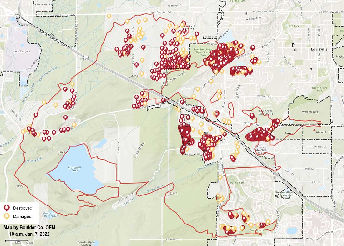
Map of structures damaged or destroyed during the Marshall Fire which started December 30, 2021. Map accessed at 10 a.m. MST January 7, 2021.
An interagency damage assessment of the Marshall Fire southeast of Boulder, Colorado updated Jan. 6 has found 1,084 destroyed residences and 149 that were damaged. The total countywide estimated value of residential damage is $513,212,589. The updated numbers for commercial structures are 7 destroyed and 30 damaged. The total value of commercial damage is still being calculated. The commercial structures included a shopping center and the Element Hotel.
Residential Structures
City of Louisville: 550 destroyed, 43 damaged; actual value of residential damage is approximately $229,199,184
Town of Superior: 378 destroyed, 58 damaged; actual value of residential damage is approximately $152,757,462
Unincorporated Boulder County: 156 destroyed, 48 damaged; actual value of residential damage is approximately $131,255,944
Within hours it burned more than 6,000 acres and nearly 1,000 structures southeast of Boulder, Colorado
FEDEX truck blown over by wind, with the Marshall Fire in the distance. Photo by Alyssa Lundgren, Dec. 30, 2021.
It seems hard to believe, but the the first firefighters and a sheriff’s deputy dispatched to the Marshall Fire southeast of Boulder, Colorado could not immediately find it. On December 30 they arrived four minutes after being dispatched at about 11 a.m. to a report of smoke and a downed power line, according to a time line compiled by Colorado Public Radio, but they did not see smoke or flames until 11 minutes after they were at the reported location.
They may have been distracted at first by what they thought was a downed power line on Marshall Road. They told the dispatcher the line is “hanging down low enough that it can touch a vehicle or trucks and people are attempting to go underneath it.” Later they found out that it was a telecommunications line that did not pose any fire danger, but apparently it was a physical hazard for motorists.
It is possible that the 11-minute delay in finding the fire was due the reported location being incorrect. Or the fire was small and light fuel such as short grass was burning which did not produce a great deal of smoke and may have been kept low to the ground by the very strong wind. Later the blaze moved into heavier fuel, and in spite of the wind produced a convection column topped by condensation.
Marshall Fire south of Boulder, CO. Posted Thursday at 12:26 p.m. MST by County Commissioner Claire Levy.
During the hour before it started, firefighters were sent to two other vegetation fires which were north of Boulder. Even with the very strong winds firefighters were able to stop both before they grew large.
These incidents may have reduced the number of fire resources that were available when the Marshall fire took off, spreading very rapidly pushed by winds gusting at 60 to more than 100 mph hour depending on the location.
Before the fires started a great deal of dust was being kicked up by the wind, then it became a mix of smoke and dust. Check out the dust blowing in this video with the fire in the background:
The wind was not predicted very far in advance for the Boulder area and there was no Red Flag Warning in effect. At 3 a.m. on December 30, about 8 hours before the Marshal Fire started, the forecasting data and models started to become clear — the wind would move from the mountains into the areas northwest of Denver. An existing wind warning was revised.
From CPR.org:
“It wasn’t a slam dunk high wind event,” said Jennifer Stark, meteorologist in charge at the Boulder office. “But ingredients were really coming together, and once we saw the latest model runs that forecaster on the midnight shift, put out that warning. And we were expecting wind gusts up around 90 miles an hour.”
Before the day was over winds would gust up to 115 mph at one location.
The warning, however, was not technically a “red flag” warning, which is specific to fire danger, and requires three elements: strong winds, cured fuels and relative humidities less than 15% for three hours or longer.
“So we had two of the ingredients,” said Stark. “We had the fuels that were cured and dry, and we had the very strong winds, but the relative humidities were actually a forecast to be in the lower 20 percents. So we did not go with the red flag warning.”
The lack of a red flag warning was a surprise to Philip Higuera, Professor of Fire Ecology at the University of Montana, Missoula, who is currently a visiting fellow at CU Boulder. He said there should be objective criteria for red flag warnings, but it should be revisited in an era of climate change.
“One of the things that we’re seeing broadly in the fire world is that the systems that we have in place are largely developed based on our past experiences,” said Higuera. “We’re increasingly seeing examples where those systems are either less applicable or no longer applicable under the conditions we’re experiencing now, in a world that’s changing rapidly.”
Still, the warning that was issued discussed the danger of a possible fire spreading rapidly, given months of drought in the region combined with the winds.
It is easy to say after the event, but wildland firefighters know that the three major factors that affect the spread of a fire are weather, fuels, and topography. Wildfires generally do not suddenly become rapidly spreading unless very strong winds are present, and they can make up for less than extreme fuel and topography.
The lengthy drought and much less than average precipitation on the Front Range of Colorado in October, November, and December helped set the stage. At 1:30 p.m. on Dec. 30 the relative humidity near Superior where much of the destruction occurred was low, 24 percent, and the temperature was 44 degrees. The extreme wind was able to overwhelm the factors of low but not extreme RH, a temperature generally not associated with fire storms, light to medium vegetation, and benign topography. The 991 structures that burned added a great deal to the fuel load. As buildings were consumed, radiant and convective heat ignited houses that in some places were only 10 to 20 feet apart, while burning embers blown by the wind lit spot fires far ahead in the home ignition zones, on structures, leaf-filled gutters, and vents, as well as bone dry lawns and mulch beds which in some cases spread to and ignited the homes.
The Boulder Office of Emergency Management declined to release to CPR a recording of the initial phone call reporting the fire.
Unlike most states, in Colorado county sheriffs have statutory responsibility to coordinate wildland fire response within their county. Sheriff Joe Pelle said his investigation had not found a power line near the point of origin. At least one search warrant has been served on a compound in that area where investigators have been seen.
The final determination of the cause is going to be huge. That, combined with snow covering the point of origin is part of the reason the investigators are taking their time, being careful and meticulous. Many of the nearly 1,000 structures destroyed are valued at $600,000 to $800,000 so regardless of what is found attorneys will no doubt file law suits.
Evacuation orders lifted for Louisville and Superior
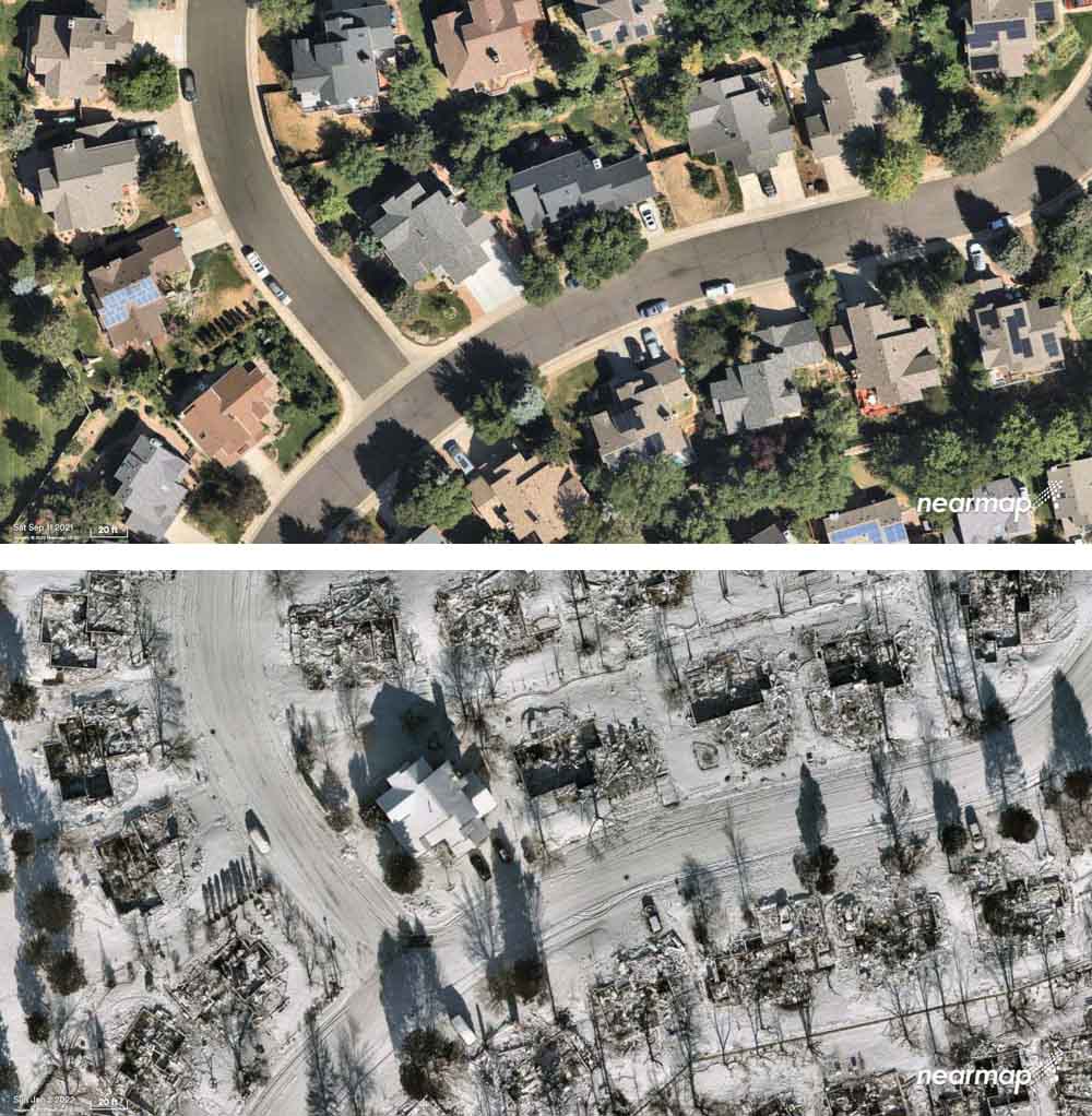
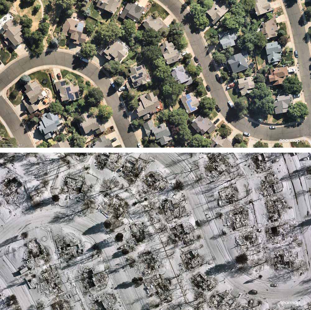
Superior, Colorado, before and after the Marshall Fire, Sept. 11, 2021 and Jan. 2, 2022. Nearmap.
Aerial photos taken of Superior, Colorado before and after the devastating December 30 Marshall Fire show the physical impact on the structures. Most of the homes within the 6,219-acre perimeter were destroyed as the fire was pushed by winds gusting, depending on the location, at 60 to 100 mph while the relative humidity was in the 20s.
Superior, Colorado, before and after the Marshall Fire, Sept. 11, 2021 and Jan. 2, 2022. Nearmap.
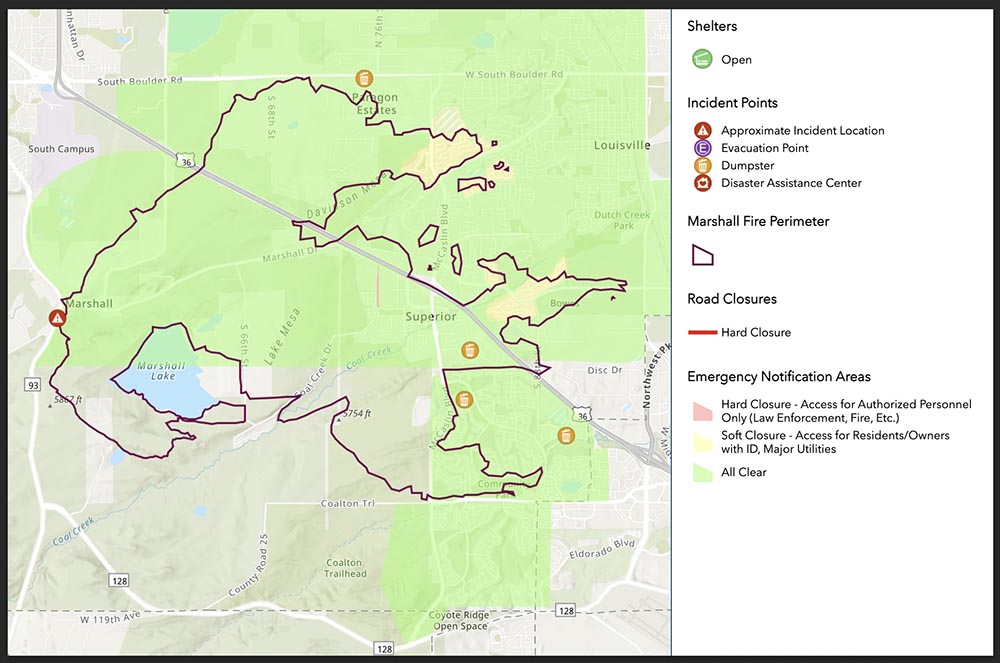
At 12 p.m. Wednesday the evacuation order for Louisville was lifted. Superior’s closures were lifted at 6 a.m. Boulder County’s map at 3:30 p.m. Wednesday showed “all clear” and no closures in effect in the fire area.
Investigators have been searching for the two persons still reported as missing at two locations. In the 5900 block of Marshall Road in unincorporated Boulder County they have located partial human remains of an adult. Investigators from both the Sheriff’s Office and Coroner’s Office continue to actively work at this scene.
The search in the 1500 block of S. 76th Street, Superior is ongoing.
There have been no other reports of fatalities tied to the fire.
The Boulder County Sheriff’s office said there are no updates on the continuing investigation into the cause and origin of the Marshall Fire. The weather has been a factor in the speed at which the investigations are able to be conducted.
The Disaster Assistance Center is available for anyone impacted by the fire. It is located at 1755 South Public Road, Lafayette, and is open from 9 a.m. to 7 p.m. every day.
President Joe Biden will be in Boulder County Friday to see the damage caused by the fire.
Below is information from Boulder County about how to help:
We know our community’s heart is huge, and everyone wants to help. Official sites are unable to accept any material donations — please do not bring these to shelters or other disaster support locations.
Victims most need money. While some families have gofundme accounts set up by friends, we cannot verify the authenticity of each of these, and we are concerned about fraud. The very best way to ensure victims receive funding, without tax implications, is to donate to www.coloradogives.org
Can’t give money, but want to volunteer? There will be many needs in the months ahead. Please do not self-dispatch to disaster areas. Please registers at: https://coloradoresponds.communityos.org/. This state clearinghouse will strive to match volunteers with community and individual needs.
Due to the recent fires, BCPH is working to determine the health risk current air quality poses. There are several air monitoring stations in Boulder and Longmont that measure regional air quality which currently report to be moderate to good. Information: https://t.co/prFb56Kfpnpic.twitter.com/6Hbnfh0Q4u
A closer look at the destruction left in the wake of the devastating #MarshallFire. This afternoon we’re speaking with folks trying to get their lives back on track. Those stories on @DenverChannel tonight at 5. pic.twitter.com/vimhURYMty
Before and after aerial imagery of the catastrophic #MarshallFire in Boulder County, Colorado via @gic_org. The imagery of destroyed homes and structures blanketed by snow is unlike anything I’ve seen post-fire. (h/t @ai6yrham) pic.twitter.com/wS8tJdU6ye
County authorities have have released a preliminary list of the addresses of structures that were destroyed or damaged in the Marshall Fire southeast of Boulder, Colorado. They described it as partial and incomplete at 2 p.m. January 1, 2022.
From the Denver Gazette, Saturday evening:
Three people are missing and feared dead in the wake of the Marshall fire, the Boulder County sheriff said Saturday [afternoon], and nearly 1,000 structures have been destroyed, making the blaze by far the most destructive in Colorado history.
Two of the three missing persons are in Superior, and the third is in the Marshall area, Sheriff Joe Pelle said. He said the search is likely a recovery one, meaning authorities are looking for remains. The missing people’s homes have been destroyed, he said, and cadaver dogs will be brought in Sunday. The debris and snow have “hampered substantially” efforts to search for the missing.
Thanks and a tip of the hat go out to Minnie and Pat.
6:12 p.m. MST Jan. 1, 2022
Map, Marshall Fire, Dec. 31, 2021.
Unlike most states, in Colorado county sheriffs have statutory responsibility to coordinate wildland fire response within their county. Boulder County, the location of the Marshall Fire, has five year-round employees with fire responsibilities. They also hire seasonal firefighters during the traditional wildland fire season.
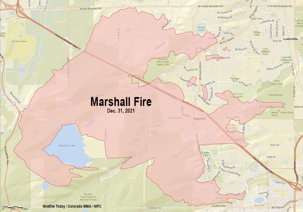
Saturday afternoon Boulder County Sheriff Joe Pelle released damage assessment numbers for the 6,000-acre Marshall Fire southeast of Boulder.
Total numbers are 991 structures destroyed and 127 damaged.
The Sheriff did not specify how many of the structures were homes. Therefore, the numbers could include backyard sheds and other small uninhabited buildings.
What caused the Marshall fire?
Boulder County has clarified information that was previously released about the cause of the fire. In a press conference Friday morning, Sheriff Pelle told reporters that someone told fire authorities that there was a downed power line near where the fire started. But origin and cause investigators had not examined the scene, he said, and the specific cause had not been officially confirmed.
Saturday afternoon the Boulder Office of Emergency Management released a statement:
As of last night, no downed power lines had been located in the area [of the origin]. There were some downed telecommunication lines, but these are not likely to have started the blaze. The sheriff did confirm that one search warrant has been obtained, but he declined to release any additional information about the location or reason for the warrant.