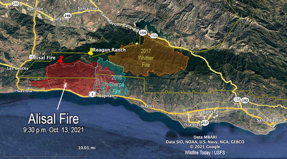
Alisal Fire vicinity map. The red line was the perimeter at 9:30 p.m. PDT Oct. 13, 2021. The white line was the perimeter about 24 hours earlier. Scroll down to see a more detailed map.
On Wednesday the Alisal Fire, 11 miles west of Goleta, California spread two miles further west and one mile to the east. On the east side it is still spreading through the five year old footprint of the Sherpa Fire.
Air tankers took advantage of decreasing winds Wednesday to apply retardant on the north side, reinforcing the West Camino Cielo road out to Gaviota on the west side. Crews conducted a firing operation along the road later in the afternoon.
Looking east at the Alisal Fire; retardant applied on the north side of the fire near West Camino Cielo road Oct. 13, 2021. Air Attack photo.
Additional evacuations were ordered Wednesday night for the area west of Arroyo Hondo to the intersection of Hwy. 101 and Hwy. 1, including Vista Del Mar School and Gaviota Beach. The ranch formerly owned by President Ronald Reagan, known as the Western White House, is also under evacuation orders. (More information about evacuations.)
To see all articles on Wildfire Today about the Alisal Fire, including the most recent, click HERE.
Thursday morning fire officials said the fire had burned 16,801 acres. Resources assigned to the fire Wednesday evening included 31 hand crews, 143 engines, and 8 helicopters for a total of 1,306 personnel, an increase of 541. Management of the fire has transitioned to a California Type 1 Incident Management team led by Jerry McGgowan.
Alisal Fire map. The red line was the perimeter at 9:30 p.m. PDT Oct. 13, 2021. The white line was the perimeter about 24 hours earlier. The red dots represent heat detected by a satellite at 1:48 a.m. PDT Oct. 14, 2021.
On Thursday firefighters are going to be faced with wind directions shifting about every six hours. Southwest winds are likely to develop in the morning, which may turn southeasterly in the early afternoon, before becoming northwesterly Wednesday evening. The relative humidity will be in the low 20s, but will rise to the mid-50s Wednesday night. Light and mostly onshore winds are in the forecast for Friday.
Alisal Fire, seen from Santa Ynez Peak, looking west-southwest at 7:04 a.m. PDT Oct. 14, 2021.Alisal Fire map, 3-D looking east. The red line was the perimeter at 9:30 p.m. PDT Oct. 13, 2021. The white line was the perimeter about 24 hours earlier.Alisal Fire map, 3-D looking west. The red line was the perimeter at 9:30 p.m. PDT Oct. 13, 2021. The white line was the perimeter about 24 hours earlier.
Below is a timelapse video of the Alisal Fire — about five hours compressed into 30 seconds. It was shot by the AlertWildfire camera on Santa Ynez Peak, looking west-southwest, from 2:20 p.m until 7 p.m., October 13, 2021.
Charred landscape at the Alisal Fire, off Refugio Road, Oct. 13, 2021
14,500 acres Wednesday morning, 12 miles west of Goleta, California
8:12 a.m. PDT Oct. 13, 2021
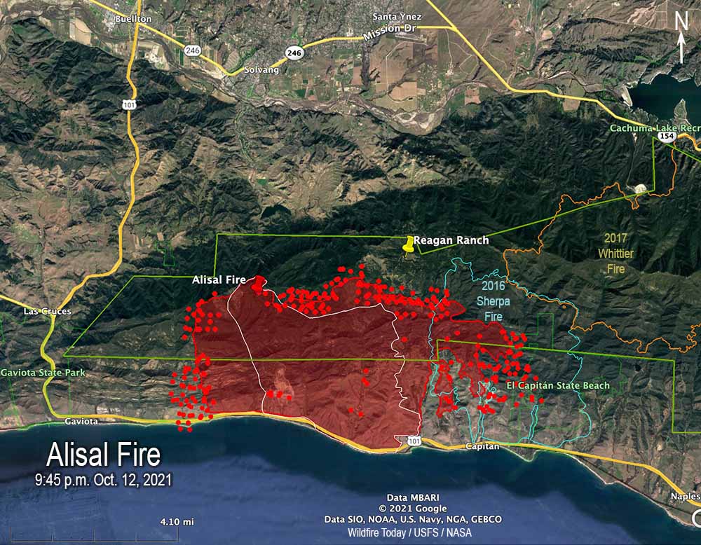
Alisal Fire map 9:45 p.m. Oct. 12, 2021. The red line was the perimeter at 9:45 p.m. PDT Oct. 12, 2021. The white line was the perimeter at 4:12 a.m. Oct. 12. The red dots represent heat detected by satellites at 2:56 a.m. PDT Oct. 13.
Wednesday morning the Santa Barbara County Fire Department said the Alisal Fire 12 miles northwest of Goleta, California has burned 14,500 acres, an increase of 1,100 acres over the figure released Tuesday evening. The growth over the last 24 hours has been on all sides, with the exception, of course, where the fire was stopped by the Pacific Ocean on the south.
The east side of the fire has burned into Sherpa Fire of 2016. During the 9:45 p.m. mapping flight Tuesday the strong winds and low fuel moisture helped it to spread two miles into the five-year-old footprint.
To see all articles on Wildfire Today about the Alisal Fire, including the most recent, click HERE.
Highway 101, the Pacific Railroad, and Amtrak lines remain closed and evacuations are still in effect. (More information about evacuations.)
On Wednesday fire officials expect to have working on the fire 5 air tankers, 6 helicopters, and a total of 1,300 personnel.
Alisal Fire map, 3-D, 9:45 p.m. Oct. 12, 2021. The red line was the perimeter at 9:45 p.m. PDT Oct. 12, 2021. The white line was the perimeter at 4:12 a.m. Oct. 12.
The spot weather forecast produced for the incident calls for 5-10 mph northeast winds Wednesday morning, becoming south to southwest at 5 to 10 mph by noon, then changing to come out of the northwest after 6 p.m. at 15 to 20 mph with gusts to 35. The humidity will be in the upper teens until it begins to rise in the afternoon. The standard NWS local forecast for the area is a little different.
Alisal Fire map, east side, 9:45 p.m. Oct. 12, 2021. The red line was the perimeter at 9:45 p.m. PDT Oct. 12, 2021. The white line was the perimeter at 4:12 a.m. Oct. 12. The red dots represent heat detected by satellites at 2:56 a.m. PDT Oct. 13.
Firefighters expect to have winds on Wednesday that will allow the use of fixed and rotor wing aircraft at least part of the day.
Firefighters on the Alisal Fire, Oct. 12, 2021. SBCFD photo.
7:09 p.m. PDT Oct. 12, 2021
Alisal Fire, seen from Santa Ynez Peak, looking southwest at 5:25 p.m. Oct. 12, 2021.
The wind slowed a bit late in the afternoon Tuesday, enough to allow fixed wing air tankers to work the Alisal Fire. At one point there were three over the fire and another four at the Santa Maria Airport 31 miles to the northwest. Helicopters have also been dropping water.
Most of the air tanker activity was on the west side, which corresponds with heat detected in that area by a satellite at 2:55 p.m. PDT. A weather station on Alisal Road recorded winds coming from the north-northwest, north, and north-northeast gusting around 20 mph hour between noon and 4:20 p.m. This could have caused more growth to the west.
The 2:55 p.m. satellite data showed significant growth on both the east and west sides Tuesday.
Fire officials said Tuesday evening the fire had burned 13,400 acres, almost double the last update.
KEYT reported that the Alisal Fire burned approximately 3,000 acres by 7:30 p.m.
7:02 p.m. PDT Oct. 11, 2021
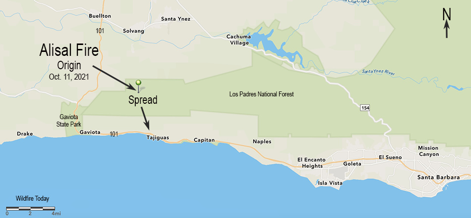
Map showing the origin location and initial spread of the Alisal Fire, October 11, 2021.
Within a few hours after it started at about 2:30 p.m. PDT Monday, very strong winds pushed the Alisal Fire three miles downhill from a ridgetop to the Pacific Ocean at Refugio State Beach west of Santa Barbara, California. Winds out of the north-northwest at 20 to 30 mph gusting to 50 drove it to Highway 101 by 5:30 p.m.
To see all articles on Wildfire Today about the Alisal Fire, including the most recent, click HERE.
Alisal Fire 3-D map, Oct. 11, 2021, looking north.
The wind was so strong that air tankers and even a mapping plane were unable to work on the fire during the initial hours.
Alisal Fire at Hwy. 101 at 5:43 p.m. Oct. 11, 2021. Via OurAirSBC
Monday afternoon the Alisal Fire was 25 miles west-northwest of Santa Barbara and 5 miles northeast of Gaviota.
Highway 101 is closed in the area and evacuations are in effect. An interactive evacuation map is available at https://arcg.is/1zO4m8. Enter your address at the top right field to determine if your area is under an Evacuation Order.
Alisal Fire, soon after it started. By Los Padres NF Air Attack. Oct. 11, 2021.
The relative humidity was surprisingly high Monday afternoon, ranging from 30 to 50 percent. The weather forecast for the fire area is for the wind to continue to be from the northwest until 10 p.m. Tuesday. The speed until 11 p.m. Monday is predicted to be 37 gusting to 49 mph, then decreasing at 2 a.m. Tuesday to 18 gusting to 24 until 10 p.m. Tuesday, after which it should drop to 5 mph out of the north. The relative humidity will peak at 71 percent at 8 p.m. Monday then steadily drop, reaching 19 percent by 2 p.m. Tuesday.
This predicted wind direction should cause the fire to spread more to the east than to the west.
Alisal Fire, looking southeast from the Refugio1 camera at 6:45 p.m. Oct. 11, 2021.Alisal Fire. Satellite photo at 5:17 p.m. PDT Oct. 11, 2021.
Incident Management Team said hundreds of giant sequoia trees have likely been killed in the fire, then revised their statement
11:47 a.m. PDT Oct. 8, 2021
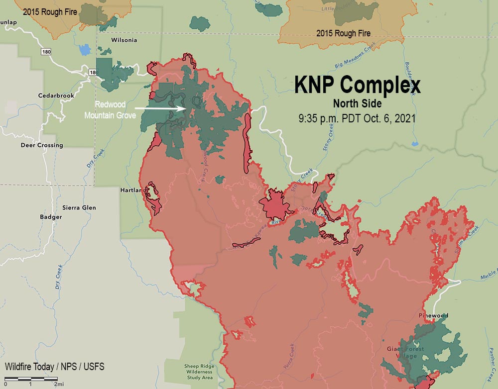
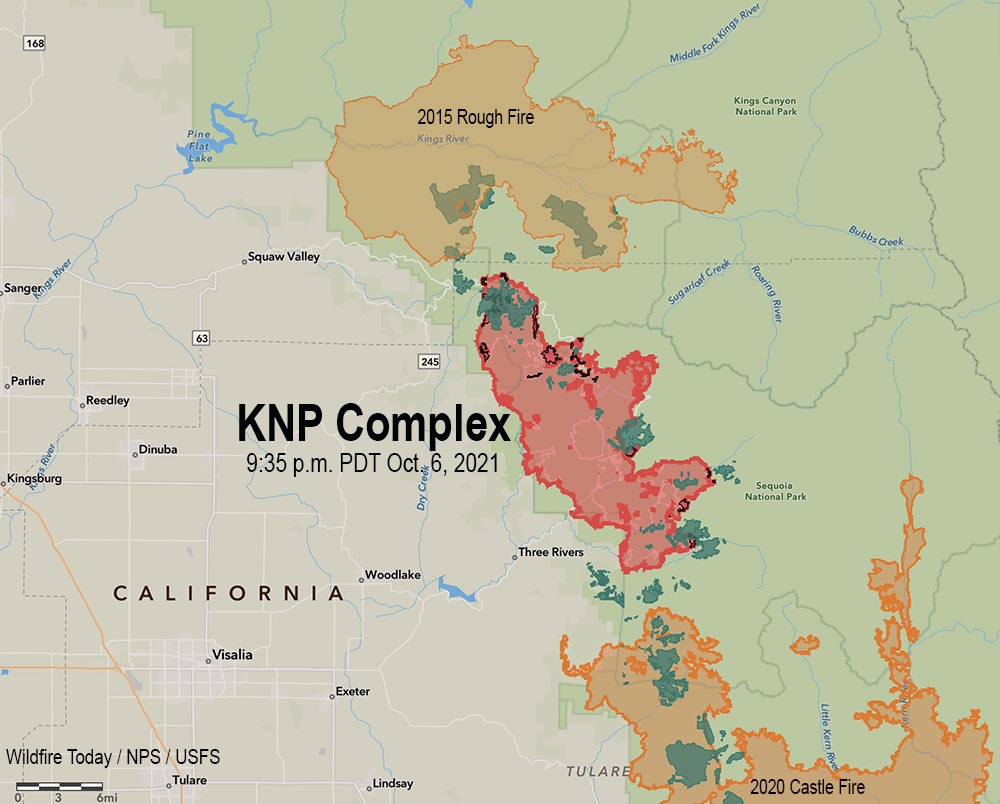
KNP Complex of fires map, north side, at 9:35 p.m. Oct. 6, 2021. The green areas represent groves of giant sequoia trees. The dark red areas showed extreme heat during the mapping flight.
Four firefighters were injured by a falling tree Thursday afternoon on the KNP Complex of fires in Southern California. The Sequoia and Kings Canyon National Parks announced Thursday night that the tree struck the firefighters who were then brought to a helispot and flown to area hospitals. The injuries were serious, the Park Service said, but the personnel were all in “stable condition.” Friday morning the agency said all four had been released from the hospitals. One is an employee with CAL FIRE and three are with the California Conservation Corps.
KNP Complex of fires map at 9:35 p.m. Oct. 6, 2021. The green areas represent groves of giant sequoia trees. The dark red areas showed extreme heat during the mapping flight.
Tuesday, October 5, the Sequoia and Kings Canyon National Parks wrote on Facebook that hundreds of giant sequoias may have been killed in the KNP Complex of fires:
Regarding the trees, there are some groves in the park that we suspect burned at high enough intensity to result in sequoia mortality, possibly for significant numbers of trees (hundreds). However, we are currently focused on prioritization and treatment of groves that are threatened and outside the current fire footprint, as well as mopping up trees that need it. It is not safe right now, nor is it our current priority to fully assess groves that have burned. These groves will be fully assessed from the ground by resource managers when it is possible, but that will be after the fire is basically out cold and conditions allow them to get in there – likely in 2022.
On Friday morning, October 8, that October 5 statement was edited, removing the estimate of trees that may have been killed, and softening the language about assessment of giant sequoia mortality not being a priority.
We suspect that some groves in the park burned at high enough intensity to cause tree mortality. We don’t know yet the extent of the fire behavior or tree mortality. We will gain what knowledge we can with aerial reconnaissance, as smoke conditions allow. These groves will be fully assessed from the ground by resource managers when it is possible, but that will be after the fire is basically out cold and conditions allow them to get in there – likely 2022.
The huge 85,952-acre fire has been divided into two zones and will be managed by two Type 1 Incident Management Teams. California Interagency Incident Management Team 2 (CIIMT2) assumed command of the North Zone Thursday at 6 pm. while the Southwest Area Incident Management Team 2 remains in command of the South Zone.
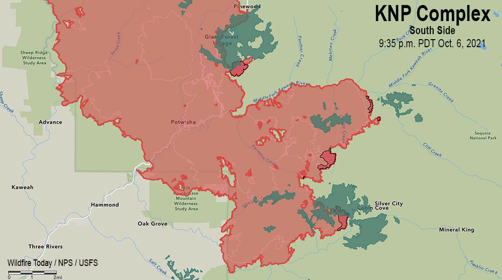
KNP Complex of fires map, south side, at 9:35 p.m. Oct. 6, 2021. The green areas represent groves of giant sequoia trees. The dark red areas showed extreme heat during the mapping flight.
Friday morning several weather stations in the general vicinity of the KNP Complex recorded less than 0.05 inch of precipitation by 10:15 a.m. PDT. More is in the forecast during the day on Friday possibly amounting to a wetting rain of a quarter of an inch or more over the northern portions of the fire. Lesser amounts of 0.10 to 0.15 inch are likely to the south in the Mineral King and Case Mountain areas. This is not expected to be enough to put out the fire, but it is likely to slow it down for at least several days. The forecast for Saturday and Sunday is for high temperatures in the 40s and 50s depending on the elevation, with very high humidities lowering into the 30s by Sunday. There is another chance for rain on Monday along with humidity in the 50s and 60s. Tuesday and Wednesday will be sunny with humidities of 25 to 40 percent. The wind will be generally moderate throughout this period.
All this adds up to reduced growth through Tuesday, providing opportunities for firefighters to construct direct firelines.
On the north zone Friday the primary focus will be the area where the fire crossed the Generals Highway south of Grant Grove. Thursday night a tactical firing operation from Park Ridge to Redwood Canyon secured that portion of the line. An indirect line is being constructed around Stony Creek Lodge to the Generals Highway. Increased humidity and shading of fuels by clouds will decrease fire behavior Friday and provide more opportunities to build direct line.
On the south zone, heavy equipment and crews are implementing structure protection actions around Case Mountain Grove, Silver City, and Mineral King. Fire spread south of Mineral King Road is being reduced with line construction and hose lays in place.
The fire in Sequoia National Park has burned more than 81,000 acres in California
8:03 a.m. PDT Oct. 6, 2021
KNP Complex of fires, near Eshom Campground, Oct. 4, 2021. InciWeb.
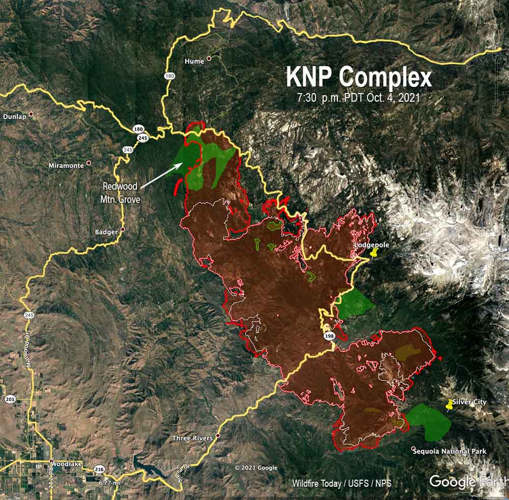
On the KNP Complex of fires in Sequoia National Park in Southern California, the smoke, which has limited the use of firefighting aircraft for days or weeks, cleared by mid-morning Tuesday more than it had in recent days which allowed the use of some aviation resources both on the north and south ends of the fire. An increase in relative humidity has slowed the spread for the last two days, allowing firefighters to construct direct fire line near the fire’s edge where conditions permit.
The blaze was mapped Tuesday evening at 81,473 acres, an increase of more than 20,000 acres in the previous 48 hours.
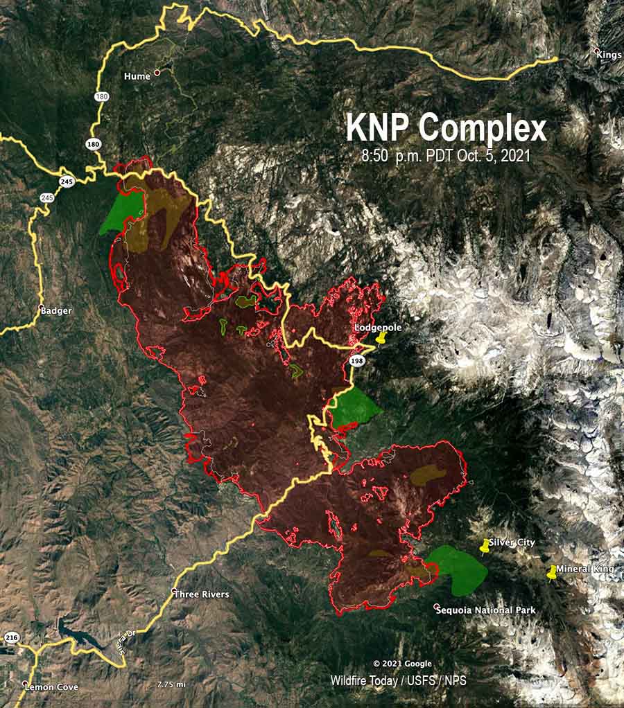
KNP Complex map, 8:50 p.m. Oct. 5, 2021. The white line was the perimeter on the evening of Oct. 4. The green areas are the APPROXIMATE locations of groves of giant sequoia trees.
Approximately 550 acres have burned north of Generals Highway one mile southeast of the community of Wilsonia. Tuesday evening Operations Section Chief Chad Rice said hand crews and dozers are constructing line around that large slop over, tying in to old fire lines, fuel treatments, and roads where they exist. That should be complete “in a few shifts,” Mr. Rice said.
A large number of firefighters are working in Grant Grove and Wilsonia to make them easier to defend if the fire spreads into those areas.
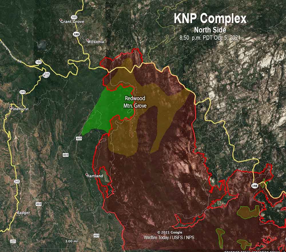
KNP Complex map, north side, 8:50 p.m. Oct. 5, 2021. The white line was the perimeter on the evening of Oct. 4. The green areas are the APPROXIMATE locations of groves of giant sequoia trees.
The incident management team has not released information about the mortality of the giant sequoias in the Redwood Mountain Grove after the fire spread rapidly through the area on October 4. It is the largest grove on Earth of the trees and contains the world’s tallest giant sequoia, 312 feet (95 meters). The huge trees with bark up to a foot thick are normally fire resistant and can live for more than 3,000 years old if climate change was not creating multi-year droughts and extremely low fuel moistures. Last year the Castle Fire, just to the south, destroyed an estimated 7,500 to 10,600 large sequoias with trunk diameters of more than four feet, which was 10 to 14 percent of all large sequoias across the tree’s natural range in the Sierra Nevada.
Near Stony Creek Lodge and Cabin Creek on the northeast side of the fire there is a 200-acre slop over across Generals Highway that firefighters are working on.
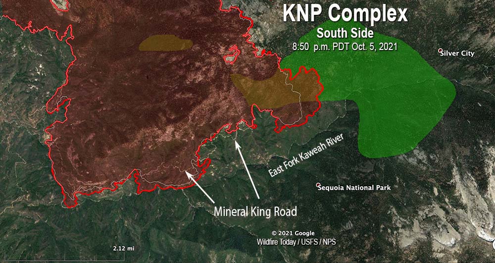
On the south side, the fire has crossed Mineral King Road in several places, which in that steep topography raises the level of difficulty in stopping the spread in that area. It has not yet crossed the East Fork of the Kaweah River, but Operations Section Chief Chad Rice said he expects it will cross to the south side. The terrain, fuels, fire behavior, and the one-lane road so far have made it unsafe for fire crews to work in some locations on the south edge of the fire, Mr. Rice said. For several hours on Tuesday a boulder the size of a car rolled down onto the road, blocking it until the boulder could be removed.
KNP Complex map, south side, 8:50 p.m. Oct. 5, 2021. The white line was the perimeter on the evening of Oct. 4. The green areas are the APPROXIMATE locations of groves of giant sequoia trees.
There are no reports of any residences being destroyed. Resources assigned to the fire include 38 hand crews, 111 fire engines, and 16 helicopters for a total of 1,866 personnel.
Lightning started two fires on September 9, the Paradise and Colony Fires, which later merged to become the KNP Complex of fires. It is burning in the Sequoia and Kings Canyon National Park and Sequoia National Forest and is being managed as a full suppression fire.
Burns most of the Redwood Mountain Grove, the largest grove of giant sequoia trees on earth.
1:30 p.m. PDT Oct. 5, 2021
KNP Complex map, north side. The red line was the perimeter at 7:30 p.m. Oct. 4, 2021. The green areas are the APPROXIMATE locations of groves of giant sequoias.
On Monday the KNP Complex of fires in Sequoia National Park, pushed by 55 mph winds, crossed Generals Highway about a mile east of Wilsonia. The extreme fire behavior forced firefighters to temporarily move to safer locations. The additional growth resulted in the fire becoming well established in Redwood Creek and burning much of the Redwood Mountain Grove, which is the largest grove of giant sequoia (Sequoiadendron giganteum) trees on earth. It contains the world’s tallest giant sequoia, 312 feet (95 meters). The amount of mortality of the sequoias is unknown at this point.
At least two very large pyrocumulus convection columns of smoke were seen Monday on the north side of the fire that rose to more than 32,000 feet, indicating extreme fire behavior.
This additional growth threatens Hartland, Quail Flat, Wilsonia, and Grant Grove. Firefighters are doing what they can to provide structure protection in these locations.
KNP Complex map. The red line was the perimeter at 7:30 p.m. Oct. 4, 2021. The white line was the perimeter about 48 hours before. The green areas are the APPROXIMATE locations of groves of giant sequoias.
The KNP Complex has burned 79,382 acres. Resources assigned include 27 hand crews, 90 engines, 35 water tenders, 18 dozers, and 13 helicopters for a total of 1,566 personnel.
On the southern side of the fire Monday, firefighters worked along Mineral King Road to contain the spot fires from Sunday night. They also provided structure protection in Silver City and the Mineral King area. Helicopters were able to support ground resources with bucket drops on Monday after the smoke cleared enough to safely fly.
On Tuesday crews are working on control lines to keep the fire out of the communities near the Redwood Mountain Grove on the north side of the blaze.
KNP Complex of fires. Uploaded to InciWeb Oct 4, 2021.