Updated 10:09 a.m. PDT August 23, 2021

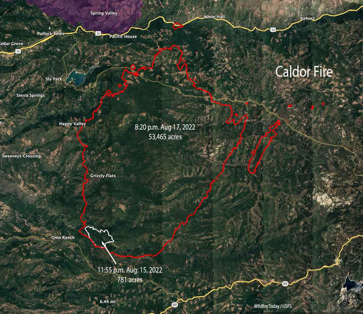
The Caldor Fire in northern California 14 miles southwest of Lake Tahoe did not spread as much Sunday as it did Saturday when it ran four miles to the northeast. Still, it added about 6,000 acres to bring the total up to 104,309 acres.
Most of the growth Sunday was on the northeast side near Kyburz, on both sides of Highway 50 where spot fires occurred up to a half-mile ahead of the main fire front. A spot fire north of the highway south of Granite Springs Road grew substantially. Under the existing conditions of weather and fuel moisture, burning embers lofted into the air easily ignite the very dry fuels.
To see all articles on Wildfire Today about the Caldor Fire, including the most recent, click HERE.
On Monday firefighters expect southwest winds to continue, with ridgeline winds of 4-9 mph. Fire growth will occur in all areas, especially on the north and northeast flanks. A minimal inversion and smoke layer should clear before noon, with fire activity increasing quickly, aided by the up-canyon breezes. Smoldering spot fires will begin to become active once exposed to the wind and sunny conditions. New spot fires could occur up to a mile ahead of the main fire front.
Diurnal wind patterns will likely cause the Caldor Fire to send smoke into the Lake Tahoe Basin during the day. After sunset a down canyon flow will cause smoke to drain down the Highway 50 corridor into Placerville and the Eldorado hills overnight.
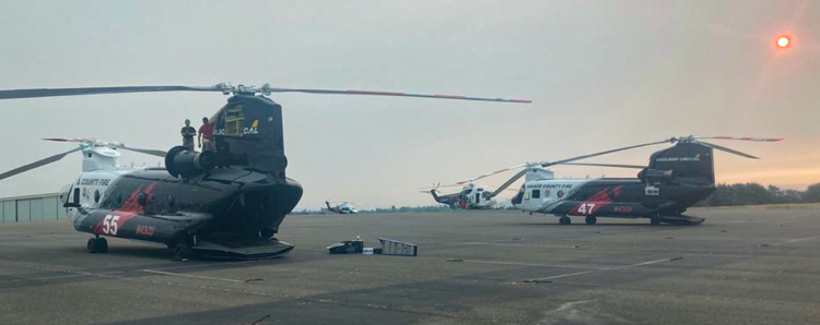
Night flying helicopters are being used to drop water at night for the first time in Northern California. On August 18 a group of three large helicopters that can carry 1,000 to 3,000 gallons was dispatched to the area from the southern part of the state. Since arriving they have been stymied by visibility problems caused by smoke trapped in inversions, but at least one was flying Sunday night. The video below shows the smallest of the three large ships, a 1,000-gallon Sikorsky S-61, dropping on the Caldor Fire. The other two are 3,000-gallon CH-47D Chinooks.
Historic night helicopter ops tonight on #CaldorFire on S side of Grizzly Flat Rd. Amazing to see night drops as part of firing operation tonight next to structures. #nighthelicopter pic.twitter.com/4U3VNzynXZ
— craig philpott (@CphilpottCraig) August 23, 2021
Due to extreme fire conditions and “strained firefighter resources throughout the country” the US Forest Service has enacted a temporary closure of nine National Forests in California: Tahoe, Plumas, Lassen, Mendocino, Klamath, Six Rivers, Shasta-Trinity, Modoc, and Lake Tahoe Basin Management Unit.
9:05 a.m. PDT August 22, 2021

The northeast side of the Caldor Fire ran for more than four miles Saturday, growing to 98,000 acres while being pushed by 8 to 10 mph winds out of the southwest gusting to 20 mph. The relative humidity measured at the Barney Ridge weather station south of the fire on Omo Ranch Road never dropped below 30 percent, which likely moderated the spread.
The fire activity slowed Saturday night as the wind decreased but spot fires were still occurring.
The weather forecast for Sunday is for high temperatures in the 70s, relative humidity 25 to 32 percent, and afternoon winds becoming southwest at 5 to 9 mph with 15 mph gusts.
The fire is along Highway 50, 14 miles southwest of Lake Tahoe and 36 miles east of the Sacramento suburbs.
During a fixed wing mapping flight at 9:15 Saturday night the Caldor Fire was less than a mile from Highway 50 in several places, but was still mostly south of the highway. A significant spot fire had become established north of the road near Kyburz.

As it spread over four miles Saturday there were numerous spot fires caused by lofted burning embers out ahead of the fire. One of the spots southwest of Sciots Camp was was documented 1.8 miles from the main front.
Firefighters expect the growth to continue Sunday in all areas, with minimal growth at the southern and eastern portions, and major growth continuing on the north and northeastern sides. Spot fires will occur a half mile ahead. The Probability of Ignition will be 87 percent, meaning 87 percent of lofted firebrands that land in receptive fuels will ignite the fuel. The wind may clear much of the smoke out making it possible for air tankers and helicopters to assist firefighters, but they may be limited or ineffective due to the wind speeds.
Officials reported that 235 residences have been destroyed, an increase of 56 from yesterday.
Resources assigned to the fire Saturday evening included 28 hand crews, 194 fire engines, 22 dozers, 15 water tenders, and 20 helicopters for a total of 1,603 personnel.
Nationally, 26,123 personnel are working on wildfires today. Six of the eight military C-130 aircraft equipped with Modular Airborne FireFighting Systems which convert them to air tankers have been activated.
Can the fire be stopped?
If it has not happened already, by the end of the day on Sunday the fire will reach the 100,000-acre threshold to be called a “megafire”– a status that until a decade or two ago was rare.
Under these conditions with the predicted weather, the heavy fuel loads, and historically low fuel moistures, there is no possibility of stopping the forward spread of the fire. There is no number of 747 air tankers or firefighters on the ground that could be effective against the flaming front of this raging inferno. The best they can hope for is to find areas on the heel and flanks where the topography and vegetation are conducive to constructing indirect or direct fire lines, and firing out when appropriate, perhaps at night when weather conditions are more likely to lead to success.