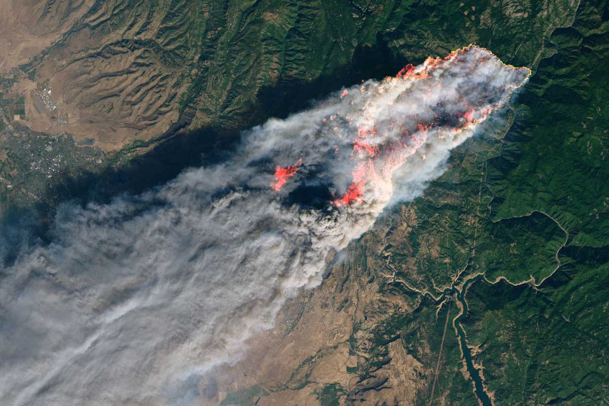
The Camp Fire, November 8, 2018. NASA (Joshua Stevens) – NASA Landsat 8.
We often publish statistics about wildfires, such as acres burned, average size, number of fires, and average size by decade. Here are some examples. Others are at an article updated February 2, 2022.
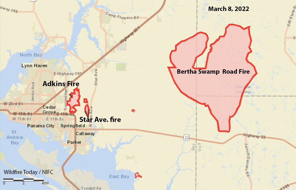
The Bertha Swamp Road Fire in Florida has burned more than 33,000 acres
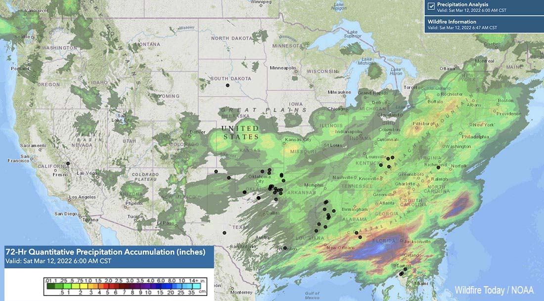
Precipitation accumulated in the 72-hour period ending at 6 p.m. March 12, 2022. The black dots represent wildfires March 12, 2022.
After a week of very busy wildfire activity across the Southern Geographic Area, rain and snow have reduced, at least temporarily, the spread of most of the blazes.
The National Interagency Incident Management Situation Report is only issued once a week about six months of the year because there are fewer large fires in the 11 western states during the fall, winter, and spring. This is the National Interagency Coordination Center’s policy “unless significant activity occurs.”
For the 7-day period that ended Thursday night the weekly Sit Report issued Friday morning listed 60 wildfires in the Southern Area that were larger than 100 acres. Those fires covered portions of three pages. The largest was the Chipola Complex that totaled 34,203 acres (and prompted evacuations). Another 10 exceeded 1,000 acres.
In the Situation Report below, scroll down to see the 60 fires in the Southern Geographic Area.
[pdf-embedder url=”https://wildfiretoday.com/wp-content/uploads/2022/03/Sit-Report-March-11-2022.pdf” title=”Sit Report March 11, 2022″]
Chipola Complex of fires
The map above shows precipitation that accumulated over the 72-hour period that ended Saturday March 12 at 6 a.m. CST. A weather station at Panama City just west of the Chipola Complex measured 0.76 inch of rain since March 9. That will be enough to slow the spread of the 33,131-acre Bertha Swamp Road Fire and help the Florida Forest Service (FFS) complete a fireline around it, but some of the heavy fuels left after the passage of Hurricane Michael could continue burning within the interior.
Bertha Swamp Road Fire, March 11, 2022. Florida Forest Service image.
The Blue Incident Management Team has started transitioning the incident back to the FFS Chipola Forestry Center.
The other two fires in the Complex are the Adkins Avenue (875 acres) and the Star Avenue (197 acres). There has not been much activity on those fires for several days.
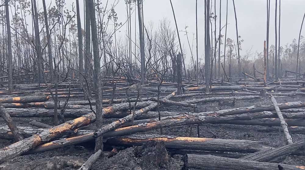
The agency reports that Hurricane Michael destroyed 2.8 million acres of trees in the Panhandle and said much of the debris remains on the ground, and will be ready to burn after a few days of dry weather.
A large wildland fire about 10 miles east of Panama City, Florida has grown substantially in the last couple of days, doubling in size to about 28,000 acres according to the Florida Forest Service (FFS).
On Tuesday afternoon the rapid fire behavior prompted evacuations in the Broad Branch community near Kinard in Calhoun County.
While the weather forecast in the coming days calls for the possibility of rain, it will not be enough, the FFS said, to decrease the wildfire threat any time soon – especially in the Hurricane Michael-impact area.
Multiple pieces of heavy equipment battle the Bertha Swamp Road Fire. FFS photo.
The fire is part of the Chipola Complex of three fires east of Panama City. The other two are the Adkins Avenue Fire and the Star Avenue Fire. Both of those are nearing containment the agency said. Evacuation orders associated with these two wildfires have been lifted.
The FFS Blue Incident Management Team has assumed command of the Chipola Complex.
Florida Forest Service wildland firefighters and resources from countless other fire and emergency service departments are working around the clock to suppress the wildfires and protect communities. “We are truly grateful for all partners and their support in this fight. We will not back down,” the FFS said in a statement Tuesday evening.
The blazes are fueled by thick, dry vegeation and dead trees left behind after Hurricane Michael in 2018.
On Monday the resources working on the fire included more than 70 tractor-plow units and 10 air assets, including 2 FFS helicopters, 2 FFS fixed-wing aircraft, 2 Florida National Guard Black Hawk helicopters, 2 Florida National Guard Guard Chinook helicopters, and 2 Southeastern Compact single-engine air tankers (SEATS).
Dozers on the Bertha Swamp Road Fire, Florida, March 7, 2022. FFS photo.
Additionally, a strike team of heavy bulldozers is focusing on building firelines and defensible space around the communities near Bear Creek. The dozers are better equipped to move large volumes of debris and to establish wider firelines than typical initial attack tractor-plow units.
The federal government has balked at paying for the treatment needed by a firefighter who was severly injuried during the burn over
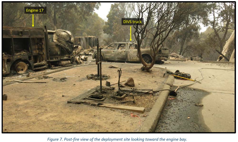
Dolan Fire deployment site. Engine & pickup. Image from the report
Congress has set aside $18 million to rebuild a US Forest Service fire station that was destroyed in the Dolan Fire in the Los Padres National Forest in Southern California in 2020.
The fire had been burning for weeks. The night before it reached Nacimiento station on Nacimiento-Fergusson Road 7 miles from the California coast highway on September 8, 2020, the fire ran for about three miles toward the station, burning 30,000 acres with spot fires three-quarters of a mile ahead. The fire personnel at the station during the burnover included two USFS engine crews, two dozers with operators, and the only Division supervisor working the night shift due to a shortage of personnel.
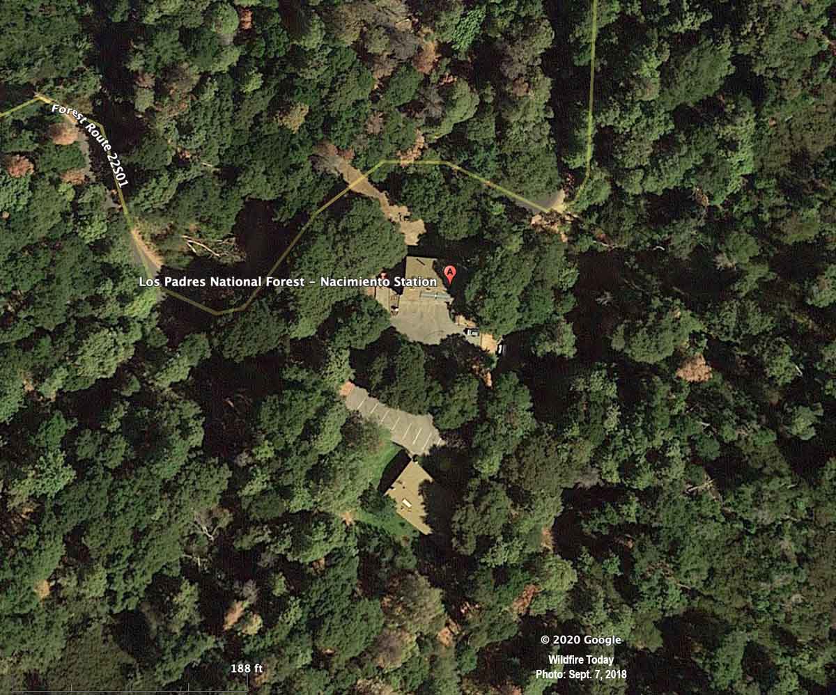
Below is an aerial photo of the Nacimiento guard station taken almost exactly two years before the burnover.
Nacimiento Station, satellite photo, September 7, 2018.
Fifteen firefighters deployed into only 13 fire shelters. Four were injured and three were hospitalized. One had very serious burns.
The Forest Service will use the funding to replace the fire station, barracks, engine garage, and pumphouse, as well as a water well, solar connections, and access roads.
These funds were provided as Supplemental Disaster Funding through the Extending Government Funding and Delivering Emergency Assistance Act of 2021. The disaster assistance funding is a share of the $1.36 billion of supplemental appropriations provided to the Forest Service.
The federal government balked at paying for treatment for injuries to one of the firefighters
According to The Tribune of San Luis Obispo, California, one of the firefighters severly injured in the burn over is still dealing with not only his on-the-job injuries, but attempting to get the government to pay for his treatment:
Casey Allen said Monday that healing from his second- and third-degree burns is continuing, with only a few small wounds left on his ankles, and his Achilles tendon on his right foot is almost completely healed.
However, the news about Allen’s injured left hand wasn’t as good: Doctors may have to amputate his ring and pinkie fingers.
He credited U.S. Rep. Salud Carbajal and his district representative Wendy Motta with finally breaking a stubborn repayment logjam so Allen and his wife Tina, who he called “my rock,” could be repaid for money they had to pay out of pocket toward his recovery.
Mr. Allen’s fiancée at the time set up a GoFundMe account for him. She wrote, “He will need hospital services for the next year at a minimum.”
Mr. Allen is suffering one of the ultimate indignities — being severely injured in a life-changing on-the-job incident, and your employer, the U.S. government, is balking at stepping up and providing the payment for your desperately needed medical treatment. The Office of Workers Compensation needs to be funded adequately by Congress so it can rebuild its staff and respond PROMPTLY to situations like this.
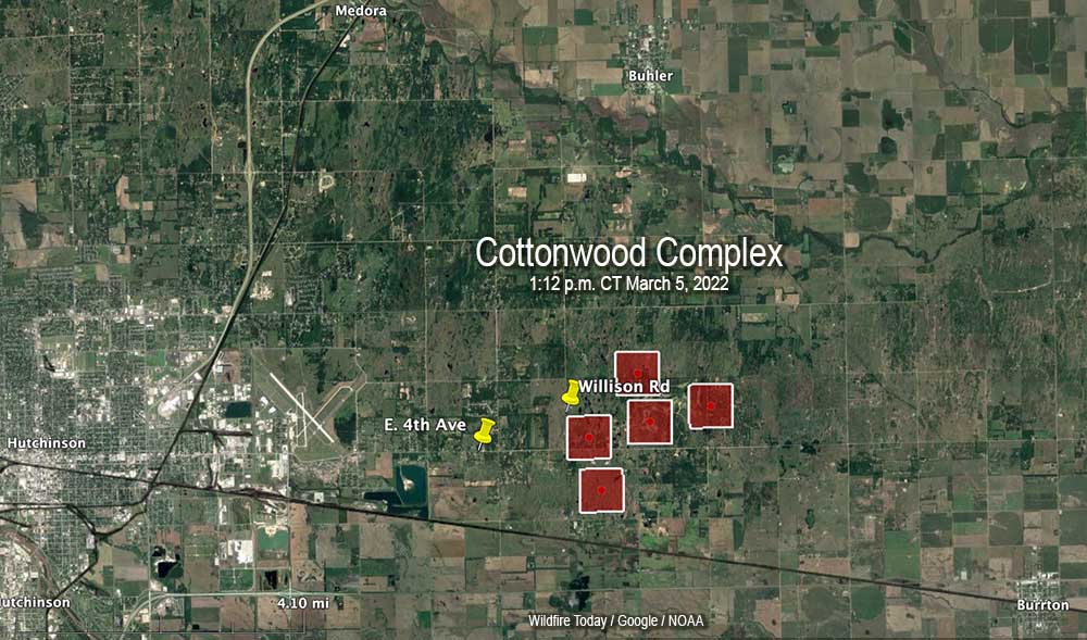
Approximately 30 air miles northwest of Wichita, Kansas
5 p.m. CT March 5, 2022
The red squares represent the approximate location of heat detected by a satellite at the Cottonwood Complex of fires, 1:12 p.m. CT March 5, 2022. The fire is east of Hutchinson, Kansas.
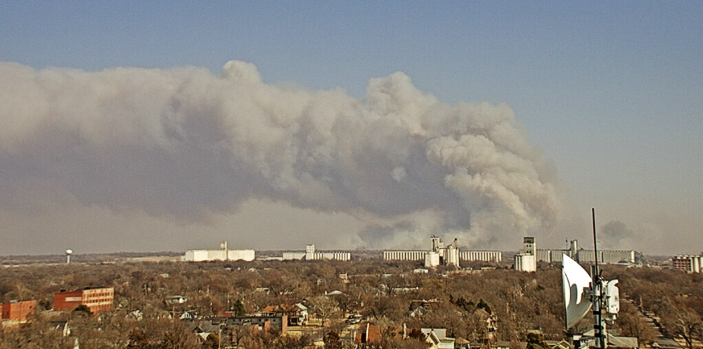
A wildfire that was reported east of Hutchinson, Kansas at about 12:30 p.m. Saturday has prompted evacuations. It started in the 800 block of Willison Road in Reno County and later spread east into Harvey County.
From The Hutchinson News:
“With Catastrophic Fire Danger and wind gusts upwards of 40 mph, firefighters had their hands full on arrival,” said Chief Doug Hanen, chief of operations for the Hutchinson Fire Department, at a 4:30 p.m. press briefing. “Units immediately engaged in structure protection and assisting residents in evacuating.”
The fire eventually crossed Buhler Road and spread rapidly through the Cottonwood Hills Golf Course, Hanen said. Winds then shifted to the west, making multiple fire fronts.
In the area of Fourth Avenue and Palamino Road, fire crews rescued several people from their homes or cars, but some residents also refused to evacuate.
Fire east of Hutchinson, Kansas, at 1:55 p.m March 5, 2022. Image from First National Bank-Hutchinson camera.
There are reports that multiple homes were damaged or destroyed and several residents suffered burns.
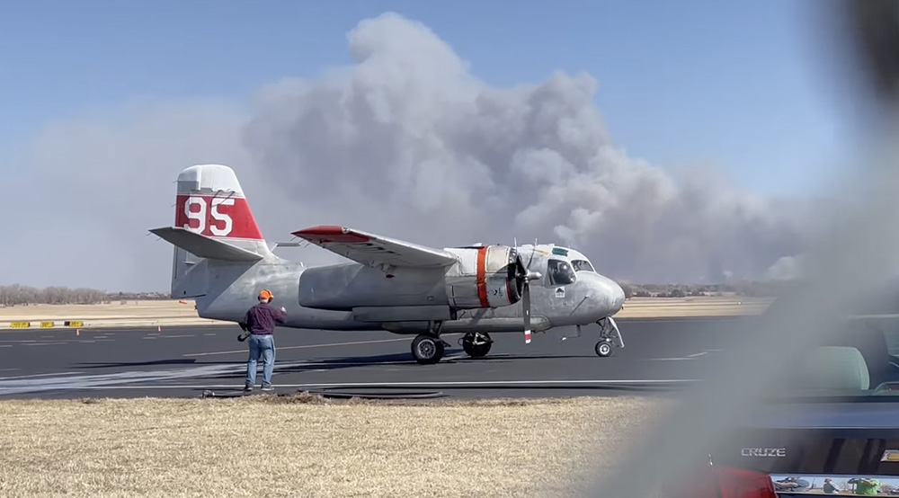
The Kansas Forest Service mobilized an air tanker, Tanker 95, a privately owned S-2 formerly operated by the California Department of Forestry and Fire Protection. It is now based in Kansas.
Air Tanker 95, an S-2, comes in for reloading with water after battling the Cottonwood Complex of fires east of Hutchinson, KS, March 5, 2022. Image by Heath Hensley.
The Kansas Division of Emergency Management has activated two UH-60 Black Hawk helicopters from the Kansas Army National Guard to assist firefighters beginning Sunday. The helicopters will have external water buckets.
Gov. Laura Kelly issued a verbal declaration of disaster emergency March 3, due to the potential for wildland fires in the state on Friday and Saturday. The declaration allows the state to preposition aerial firefighting assets from the Kansas Forest Service for a quicker response to any fires that may begin.
The video below shows Tanker 95 arriving to be reloaded with water. Smoke from the fire can be seen in the background.
The area is under a Red Flag Warning on Saturday. Strong winds were predicted to come out of the west at 25 to 35 mph with gusts to 50 mph, with relative humidity as low as 10 to 15 percent.
Red Flag Warnings, March 5, 2022. NWS.
On February 8 another fire in the same general area ran for about two miles pushed by winds gusting at more than 30 mph. Shortly after it started Fire Marshal Michael Cain was investigating to determine if it was caused by embers from some of the 75 brush piles that were ignited on private land.
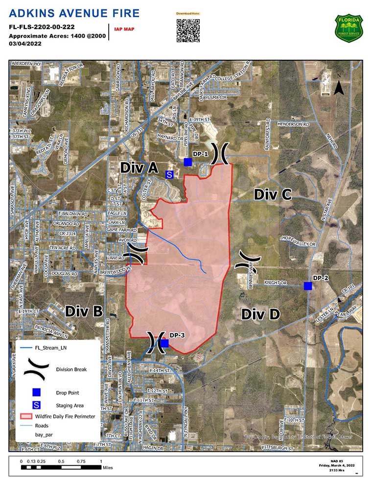
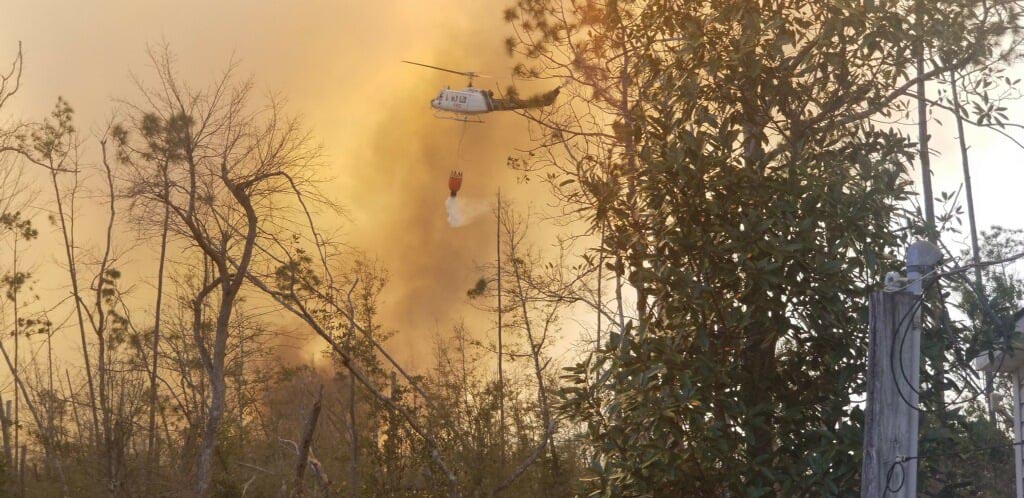
A fire on the east side of Panama City, Florida prompted the evacuation of about 600 homes, according to the Florida Forest Service (FFS). As of Friday evening the Adkins Avenue Fire had burned 1,400 acres in Bay County between U.S. 231 and Tram Road, west of North Star Avenue. The blaze is fueled by vegetation that was affected by Hurricane Michael in 2018.
Friday night the FFS reported that two structures have been destroyed and another 12 were damaged.
Helicopter drops water on the Adkins Avenue Fire. Photo: Bay County Emergency Services.
At least 200 personnel are committed to the fire including 12 tractor plows and multiple helicopters along with fire personnel from local and county departments.
Red Flag Warnings, March 5, 2022. NWS.
The area is under a Red Flag Warning until Saturday evening for 10 to 15 mph southeast winds gusting to 25 mph with relative humidity of 25 to 45 percent.