Prescription for keeping new fires from becoming megafires

Dr. Gabbert’s prescription for keeping new fires from becoming megafires:

Rapid initial attack with overwhelming force using both ground and air resources, arriving within the first 10 to 30 minutes when possible.

I am not a doctor, but some of us remember when this was standard operating procedure, at least in the federal government. CAL FIRE still understands and practices this strategy.

One of our loyal readers sent us some information about a June 19 fire on the El Dorado National Forest in California. A cooperator, CAL FIRE, helped the U.S. Forest Service by sending three S-2 air tankers, arriving at the fire 16, 19, and 30 minutes after the first smoke report. The U.S. Forest Service dispatched one helicopter and some ground forces to their fire.

It was contained within the first hour.

On the day of the fire the USFS had somewhere between zero and two large air tankers in the state of California.

Fires like this, success stories, don’t make the news. But they do when they burn 44,330 acres and 254 structures and cost taxpayers $17.9 million to suppress.

Until 2002 the U.S. Forest Service also subscribed to this initial-attack-with-overwhelming-force strategy, which works when you’re fighting wars and fires. Now that the federal firefighting budgets have been reduced and the air tanker fleet has withered away from 44 to 9 exclusive use large air tankers for the entire country, they have abandoned that policy.

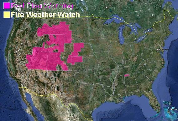
Red Flag Warnings, June 26, 2012 – Dry lightning possible

Red Flag Warnings, wildfire, June 26, 2012Dry lightning is possible today for southeast Wyoming and portions of Colorado and Utah. Dry lightning means thunderstorms with lightning but with little or no rain reaching the ground. It will also be very windy in most of these areas. The temperatures will be in the 90s or over 100, and the relative humidity will be very low.

If the dry lightning actually occurs, and if there is a substantial number of new fire ignitions, firefighters are going to be busy.

How to install a MAFFS II in a C-130J

OK, it’s not exactly a training film, but this 5-minute raw video can give you an idea of what it takes to install a Modular Airborne FireFighting System (MAFFS) in a military C-130J. The military air tankers can help provide additional air tanker support for wildfires if all of the contracted large air tankers are committed.

The video was shot Sunday June 23, 2012 at the 153rd Airlift Wing, Wyoming Air National Guard, in Cheyenne, Wyoming as crews prepared two C-130 aircraft for missions in the Rocky Mountain Geographic Area.

Four of the aircraft became operational at Pueblo air tanker base on Monday and performed three drops on the Waldo Canyon fire since the first midday launch. As of 5:20 p.m. MT they were on hold due to poor visibility at the fire.


Thanks go out to Dick

Critical fire weather expected in the Black Hills on Tuesday

windOn Tuesday the Black Hills could experience dry lightning on what is expected to be the hottest day of  the year so far. With temperatures above 100, relative humidity below 15 percent, and windy conditions, firefighters on Tuesday could be busy. In the southern Black Hills the 18 mph winds gusting to 28 could fan into life leftover lighting ignited fires from the mostly wet thunderstorms that passed through Monday afternoon and night.

The South Dakota State Fire Meteorologist, Darren R. Clabo, distributed this message Monday afternoon:

======================================================

A very warm and dry week is expected with excessively critical fire weather conditions expect for West River and the Black Hills on Tuesday. A few showers and thunderstorm (mostly wet) will pass over the region tonight. Unfortunately, this also means lightning strikes on the eve of a critical fire weather day. The hottest day yet this year will occur tomorrow as a large amplitude upper level ridge builds into the region: highs will be at or above 100 degrees with RHs below 15%. In addition, a strong pressure gradient will develop over western SD in the afternoon leading to gusty southwesterly winds. To add insult to injury, enough instability will be present to warrant a threat for dry lightning for the Black Hills and surrounding plains. Red Flag Warnings are in place for this region. East River will see cooler conditions with highs in the 80s and 90s and RHs from 30-40%. Conditions wills moderate on Wednesday as an upper level trough skirts the area. Temperatures will be in the 80s and 90s with RHs between 20 and 30%. Northerly winds are expected. Similar conditions will be seen Thursday but far southwestern SD may have minimum RHs drop below 15%. Temperatures in the 80s and 90s with RHs from 20-30% are expected Friday and through the weekend. To summarize, very hot and dry fire weather conditions, more representative of late July and August, have arrived. (Darren Clabo)

Area Command Team activated for Colorado fires

An Area Command Team (ACTeam) has been activated to assist in managing the wildfires in Colorado and the Rocky Mountain Geographic Area. There are three ACTeams in the nation, and this one, Team 2, is headed by Bob Anderson, the “Area Commander”. For this assignment they are designated “Front Range Area Command”.

These teams are not used very often, typically one to three times a year, and this is the first time one has been used in 2012.

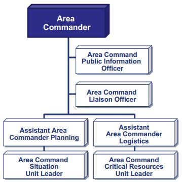
Area Command Team organization

An ACTeam does not directly manage fires or other types of incidents, but they supervise IMTeams assigned to individual fires, or they can oversee the management of a very large incident that has multiple IMTeams engaged.The ACTeam works for the Agency Administrator where the incident is occurring. They will receive a written delegation of authority and will in turn issue one to each IMTeam they supervise.

The primary functions of an ACTeam include:

  • Reduction of the workload for the agency administrator on whose jurisdiction the incident occurs. This can be especially helpful if one agency has multiple large incidents.
  • Coordination and priority-setting of limited resources among incidents, including the the demobilization, reassignment, or sharing of resources between incidents.

These teams are much smaller than a Type 1 or Type 2 IMTeam and usually consist of 7 people when first assigned, but can grow to around 15.

Area Command Team