8 fires burning in Yellowstone

Point fire, 1419 9-2-2011
The Point fire, east of Yellowstone Lake in Yellowstone National Park, as seen from Mt. Washburn, at 2:19 p.m. September 2, 2011

Thunderstorms over the last two months have left eight small wildfires that are still burning in Yellowstone National Park. The largest is the 15-acre Gibbon fire which started on July 12 southeast of Madison. The others, which started between August 25 and 31, range from 0.1 acre to the six-acre Point fire shown in the above screen capture from the live web camera on Mt. Washburn. The eight fires have been grouped into what is now known as the “Heart Complex” of fires.

Only one of the fires within the park is being suppressed, that being the 1/10-acre Specimen Fire, located along the east fork of Specimen Creek approximately a half mile from High Lake and a third of a mile from the boundary of the Gallatin National Forest. Due to its proximity to the forest, Yellowstone and Gallatin wildland fire managers determined that suppressing the fire would be the best management strategy.

Heart_Complex_Fire_Map
Map of the 8 fires in Yellowstone NP known as the Heart Complex. September 2, 2011. Credit: NPS


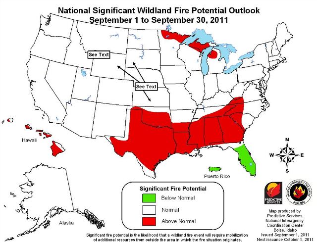
Wildfire potential, September through December, 2011

The Predictive Services section at the National Interagency Fire Center has issued their National Wildland Significant Fire Potential Outlook for September through December, 2011. If their prediction holds true, it looks like average or below average wildfire potential for most of the United States, except for Texas, Oklahoma, and the southeast.

Wildfire Outlook September 2011Wildfire Outlook October - December 2011


Video of fire near Dubois, Wyoming

Here is a video that a local resident shot of firefighting activities on August 22, 2011 near Dubois, Wyoming. The action starts at around the 3:00 minute mark. The narration is interesting. As a lead plane makes a pass the videographer says:

I think it’s spraying that stuff.

But the editing is interesting, doing slow-motion replays of the air tanker drop.

Check out the excellent photo of Tanker 910, a DC-10, dropping on a fire in Oregon on Monday.

Dozer transport burned on Idaho fire

Posted on Categories Uncategorized
Salt fire 8-28-2011
The title of this photo on InciWeb is "Aug 29 fire reaches edge of safety zone". And the caption there reads: "Waiting it out. The truck was not damaged by the fire." Photo by Todd Camm.

A dozer tranport burned on Monday, August 28 on the Salt fire southwest of Salmon, Idaho.

From Inciweb:

Salmon, Idaho, Aug. 29, 2011-The Salt fire, 16 miles southwest of Salmon, made an estimated three-mile run on Monday, according to fire officials.

One “dozer transport,” a truck pulling a trailer used to haul bulldozers, was reported burned Monday afternoon, on the fire’s east side.

However, no firefighters were injured, officials said.

“We heard that one firefighter did pull out his fire shelter,” Bob Sommer, the incident commander said. “But, we understand that a safety officer took the firefighter to the safety zone.”

“Everyone made their way to the designated safety zone. Everybody is safe and accounted for,” Sommer said.

Sommer said there are no reported injuries.

It’s standard practice for firefighters to always have safety zones close at hand, Sommer said. Safety zones are areas already burned or otherwise lacking flammable material.

Forest Service officials have begun an investigation, Frank Guzman, forest supervisor of the Salmon-Challis National Forest said.

The Salt fire’s run was visible for much of the afternoon from Salmon, with large smoke columns rising high into the air throughout the afternoon.

Today the Salt fire is listed at 4,679 acres with 5% containment. More information is at InciWeb.

Salt fire smoke column
Salt fire smoke column. An undated photo on InciWeb. Photo by Matt Call

Thanks go out to Matt

Do us a favor. If you appreciate this article or others on Wildfire Today, click the +1 button at the bottom of the article to recommend it to Google. Thanks!

Dollar Lake fire on Mt. Hood

Dollar Lake fire
Photo by Photonut

The Dollar Lake fire burning on the lower slopes on the north side of Mt. Hood in Oregon is providing some excellent photo opportunities.

Photo Dollar Lake fire
Photo: Judybug

The fire was officially reported Monday night to be 600 acres, but on Tuesday, the fire reached 1,500 acres, according to Jeree Mills, a Northwest Interagency Coordination Center spokeswoman. Several campgrounds have been closed. Suppression of the fire is hampered by strong winds, heavy fuels, and long-range spotting. Firefighters are protecting the historic Cloud Cap Inn, a large building with a shake shingle roof, by wrapping it in fire shelter material.

Zenfolio has a gallery with some excellent shots of the fire taken by Dan Kleinsmith.