Real-time wildfire location data continuously from high altitude balloons

Raven Aerostar Thunderhead Balloon image photo fire wildfire
A thermal camera image (left) taken at the same time as a visible camera image (right). Both images were captured by one of Raven Aerostar’s Thunderhead Balloon Systems while station-seeking above and monitoring a wildfire. While billowing smoke obscures the visual image, active flames are identified as bright white markings on the thermal image, offering actionable information for containment efforts. Raven image.

This article first appeared on FireAviation.com.

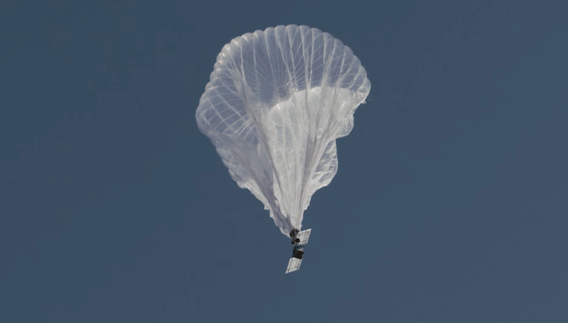
When Bob, one of our readers, asked if I was aware that for several days a high altitude balloon had been seen on a flight tracking app maneuvering at 62,300 feet over the Dixie Fire in California I told him no, but I would check into it.

It was operated by Raven Aerostar, a company based near Sioux Falls, South Dakota, which has been working with lighter than air technologies since 1956. We contacted the Communications Manager for the company, Lisa McElrath, who told us that in June, July, and August they launched one of their Thunderhead Balloons from South Dakota and flew it west to monitor wildfires. While traveling more than 16,000 miles during its 70-day flight it engaged in station-seeking  above four active fires — the Robertson Draw Fire (Mont.), the Dixie Fire (Calif.), the Dixie-Jumbo Fire (Idaho), and the Dry Gulch/Lick Creek fire (Wash.) — collecting visible and thermal imagery for extended periods of time.

Raven Aerostar balloon
Raven Aerostar balloon just after launch. Still image from the video below.

We asked Ms. McElrath if Raven been cooperating with the federal land management agencies in mapping fires. She said not yet, but that representatives from the National Interagency Fire Center had reached out to them and expressed interest in discussions after the fire season slows down.

“We can provide real-time imagery from the balloon today in the visible and infrared,” Ms. McElrath said. “In the future, the goal would be to automate the detection and download of critical imagery, fire perimeters, likely fire-starts, and other key information via onboard processing so that more actionable information would be available. We see stratospheric balloon technology being the key to cost-effective, scalable wildfire surveillance that reduces time between new fire detection and response. Effectively, balloons can alert firefighters to a new fire while it is still small, before the fire grows into something newsworthy and very expensive.”

She said the balloons can also serve as radio repeaters for personnel on the ground and could collect information from tracking devices on firefighting resources which could then be displayed on a map.

There are several paths that could lead to what we have called the Holy Grail of Wildland Firefighter Safety: knowing the real time location of a fire and firefighters. This could be one of them.

There are at least half a dozen companies in the U.S. that are working with high altitude balloons. Google Loon was one of them until they shut down a few months ago. Their goal was to help provide internet connectivity to the last one billion residents on the Earth, beaming it down from balloons. The company announced that it could not become commercially viable, around the time that thousands of SpaceX’s internet satellites were appearing in orbit.

The high altitude balloons navigate to locations by changing altitude to find wind directions that serve their needs.

“For the past nine years, Raven partnered with Loon on the development of this unique technology,” said Jim Nelson, Division Manager of Raven Aerostar. “Loon launched and navigated thousands of balloon platforms to help serve its mission. In parallel, we leveraged the Loon partnership and our 60-year history of balloon expertise to design and build our Thunderhead stratospheric platform. Thunderhead systems navigate using altitude steering, moving up and down to find favorable winds, just as the Loon balloons did. Because no lift gas or ballast is consumed during maneuvering, Thunderhead balloons can remain aloft for weeks to months at a time.”

The stratospheric balloon system works best in fleets or constellations of balloons that share wind information to improve navigation and share the sensor workload. This is explained in the video above.

All of the electrical power on the balloons comes from solar panels, which charge batteries for night operations.

Thanks and a tip of the hat go out to Robert.

Person responsible for helicopter crash that killed 9 firefighters gets early release from prison

Steven Metheny served less than half of his sentence

Sikorsky S-61N helicopter

Last week a judge granted an early release from prison for  Steven Metheny, the former Vice President of Carson Helicopters. Mr. Metheny’s falsification of records and other illegal acts led to the overloading of a helicopter that crashed while attempting to take off from a remote helispot in Northern California in 2008, killing seven firefighters and two pilots.

In August, 2015 he began serving what was to have been 12 years and 7 months in prison, but was released after six years and one month.

He pleaded guilty in 2014 to one count each of filing a false statement and of conspiracy to commit mail and wire fraud while submitting documents to obtain $20 million in firefighting contracts with the U.S. Forest Service.

He had filed for compassionate release from prison at least twice, first in November, 2020 citing his fear of contracting COVID-19, which was refused by a judge. In March of 2021 he filed again, saying his health was deteriorating. Over the next six months information was submitted indicating that he had chest pain, an abnormal echocardiogram, vision problems, high blood pressure, and migraine headaches.

U.S. District Court Judge Ann Aiken who was the judge in the trial, denied the first request but in September, 2021 approved the second one saying that his time in prison, especially with his health problems, have “been harsher than the sentence originally contemplated at the time of sentencing.”

Nina L. Charlson, mother of 25-year-old Scott Charlson of Phoenix, Oregon who died in the crash, said, “If it was a stupid mistake we would still have heartache but we all make mistakes. It was not a mistake. He plotted and planned to lie to the government.

“After the crash happened he plotted and planned to cover his plot up, Charson said. “It took the National Transportation board one and a half years to dig up the truth about what he did. It took 5 more years to get him sentenced to prison in September, 2015 for 12 years and 7 months. He served 6 years which is less than half of what he was sentenced for.”

Mr. Metheny was accused of falsifying performance charts and the weights of helicopters his company had under contract to the U.S. Forest Service for supporting wildland fire operations. As of a result of his fraud, a Carson helicopter crashed while trying to lift off with too much weight from a remote helispot on the Iron 44 Fire on the Shasta-Trinity National Forest near Weaverville, California in 2008. He was sentenced to 12 years and 7 months in prison in 2015 for attempting to defraud the government out of more than $32 million and has been serving time in Lompoc, California.

Nine people were killed, including the pilot-in-command, a U.S. Forest Service check pilot, and seven firefighters. The copilot and three firefighters were seriously injured.

Mr. Metheny went to great lengths after the crash to attempt to conceal the fraud. When he knew that investigators would be examining the company’s operations, he directed other employees to remove weight from other similar helicopters, including taking off a fuel cell and replacing a very heavy battery with an empty shell of a battery. Some of the employees refused to participate in that deception, with one explaining that he was done lying about the helicopter’s weight.

According to the National Transportation Safety Board, there was “intentional wrong-doing” by Carson Helicopters that under-stated the weight of the helicopter and over-stated its performance in the documents they provided to the U.S. Forest Service when bidding on their firefighting contract. The NTSB estimated that the actual empty weight of the helicopter was 13,845 pounds, while Carson Helicopters stated in their contract proposal that the weight was 12,013 pounds. For the purpose of load calculations on the day of the crash, the pilot assumed the weight to be 12,408 pounds, which was 1,437 pounds less than the actual weight estimated by the NTSB. According to the NTSB, for the mission of flying the firefighters off the helispot that day, the helicopter was already over the allowable weight even without the firefighters on board.

In Mr. Metheny’s plea agreement there was an admission that the helicopters had not actually been weighed.

Killed in the crash were pilot Roark Schwanenberg, 54; USFS check pilot Jim Ramage, 63; and firefighters Shawn Blazer, 30; Scott Charlson, 25; Matthew Hammer, 23; Edrik Gomez, 19; Bryan Rich, 29; David Steele, 19; and Steven “Caleb” Renno, 21. The copilot and three other firefighters were seriously injured.

Thanks and a tip of the hat go out to Nina and Kelly.

At least two dozen giant sequoia trees destroyed in Windy Fire

Smokejumpers climbed one tree to knock down fire in upper limbs

11:33 a.m. PDT Oct. 1, 2021

Windy Fire map 8:45 p.m. PDT Oct. 1, 2021
Windy Fire map at 8:45 p.m. PDT Sept. 30, 2021. The green areas are giant sequoia groves. The black line inside the Windy Fire was the perimeter on Sept. 27, 2021. The “Fawn Fire” should be labeled “French Fire”.

Some of the giant sequoia trees that can live for more than 3,000 years  are being killed in the Windy Fire which has burned about 89,800 acres east of Porterville in Southern California. The huge blaze is burning in Tule River Indian Reservation; the Sequoia National Forest, including the Giant Sequoia National Monument; and Tulare County and state responsibility areas.

The multi-year drought has led to extremely dry fuel moistures which is causing wildfires in California and other areas to burn with unusual intensity, making even some of the giant sequoias with bark up to a foot thick susceptible to wildfires burning under these conditions.

The giant sequoias are found in groves, seen as green areas on the map above.

CNN is reporting that Garrett Dickman, a wildfire botanist with Yosemite National Park who is leading personnel protecting the big trees, said an early assessment indicates that at least 29 of them have died so far.

From CNN:

While the assessment is just beginning, there’s already grave concern. The center of Long Meadow Grove managed well, thanks to work crews did in preparation for the fire, but moving away from that area, Dickman counted 29 sequoias that were “just incinerated” by the blaze.

“There were four of those that had burned so hot that they’d fallen over,” Dickman said, adding one tree burned so badly that it was nearly reduced to just an outline of a tree on the ground. “The majority of the grove is going to survive,” Dickman said, “but there are portions that burned so hot and those trees won’t make it.”

Elsewhere in the forest, Dickman has seen even more devastation. In Starvation Creek Grove, which he says has no modern fire history, he said he saw only “a couple of trees survived.”

“It was one of the groves where we got a few hours of prep work and those trees that we did the emergency prep work around, from the picture, they are the ones that did survive and all the rest of them — it doesn’t look promising,” Dickman said, adding that he plans to assess the grove in the next few days.

Smokejumpers are firefighters who arrive at a fire by parachute. They are trained to climb trees in order to retrieve chutes hung up in trees. Some of them assigned to the fire are going to climb the iconic Bench Tree in the Trail of 100 Giants and use a fire hose to apply water to an adjacent sequoia that has fire burning in some of the upper limbs. This may be unprecedented, or at the very least, it is very uncommon.

The National Park Service reported that, “…preliminary estimates suggest that the 2020 Castle Fire [just north of the Windy Fire, see, map above] killed between 31% to 42% of large sequoias within the Castle Fire footprint, or 10% to 14% of all large sequoias across the tree’s natural range in the Sierra Nevada. This translates to an estimated loss of 7,500 to 10,600 large sequoias (those with trunk diameters of 4 feet or more).”

The Windy Fire was active Thursday, growing by about 1,800 acres, and is expected to be more so on Friday. On Thursday there was significant spotting on the south and west sides.

Crews have documented 14 residences, 12 outbuildings, and 2 commercial structures that have been destroyed.

Resources assigned to the fire include 71 hand crews, 136 engines, 17 helicopters, 23 dozers, and 12 water tenders for a total of 2,500 personnel.

The top priority continues to be the southwest side where crews are making good progress securing containment lines and providing structure defense around Sugarloaf and Sugarloaf Mountain Park north towards Pine Flat and California Hot Springs.

If weather conditions on the northwest side permit, Friday crews will continue a tactical firing operation to help improve containment lines.

On the east and southeast sides helicopters and the Bombardier CL-515 Super Scooper have been dropping water and retardant on the upper ridge to slow the fire’s movement east towards the Kern River.

Tulare County residents can sign up to receive county emergency notifications by registering at AlertTC.com.

Information about evacuations can be found at the Tulare County website.

EPA attempts to compare smoke impacts from wildfires and prescribed fires

Releases 438-page report

8:08 a.m. MDT Oct. 1, 2021

EPA study, prescribed fire and wildfire

The release of a 438-page study by the US Environmental Protection Agency to compare the smoke impacts from prescribed vs. wildfire is not a ground-breaking event that will change fire management.

Titled, “Comparative Assessment of the Impacts of Prescribed Fire Versus Wildfire (CAIF): A Case Study in the Western U.S.”, the large 28MB .pdf file can be downloaded here.

In January 2020, the Wildland Fire Leadership Council, an intergovernmental committee formed to support the implementation and coordination of Federal Fire Management Policy and chaired by senior leadership in the U.S. Department of Agriculture and Department of the Interior, requested and paid for the EPA to lead an assessment to characterize and compare the smoke impacts of prescribed fire and wildfire under different fire management strategies, including prescribed fire.

They evaluated two fires, the 3,000-acre Timber Crater 6 Fire that occurred in Oregon in 2018 and the 150,000-acre Rough Fire of 2015 in the Sierra NF, Kings Canyon National Park, and Sequoia NF of California. I could not find any indication that the researchers studied a prescribed fire, which usually burn with different fire behaviors than a wildfire.

The poorly edited report is not light reading and is a slog to wade through the hundreds of pages.

Many of the report’s “key insights” will not be a surprise to land managers (or anyone with a little common sense and exposure to fire management). Here are samples from Chapter 9, “Integrated Synthesis”:

  • Smaller wildfires produce fewer public health impacts than larger wildfires.
  • Convincing the public to evacuate or use air cleaners or HVAC filters to decrease exposure to PM2.5 can decrease public health impacts from smoke.
  • If a wildfire spreads into an area previously treated with prescribed fire it can reduce additional spread of the wildfire.
  • Smoke plumes that do not intersect with high population areas or last only a few days are less likely to have substantial health impacts than fires affecting larger populations for longer periods.

Update at 3:19 p.m. Oct. 1, 2021:

After publishing the article above, we heard from Bob Yokelson with the Department Chemistry at the University of Montana. He and others have produced data showing the differences between smoke produced by prescribed fires and wildfires. It’s all in their paper, “Aerosol Mass and Optical Properties, Smoke Influence on O3, and High NO3 Production Rates in a Western U.S. City Impacted by Wildfires.”

Here is the passage Mr. Yokelson sent us:

“We stress that there is now more than 1,000 hr of ground‐based data from Missoula, suggesting that a typical PM2.5/CO value for aged wildfire smoke at the surface is about half the value in fresh to moderately aged well‐lofted wildfire plumes (Collier et al., 2016; Garofalo et al., 2019; Liu et al., 2017). One airborne wildfire study by Forrister et al. (2015) at lower latitudes and sampling elevations than the other airborne studies is consistent with the downwind net evaporation we apparently observe in Missoula.

“We also stress that, despite the evidence for PM evaporation during aging, there are strong data discussed next, supporting the idea that wildfires produce more PM than spring or fall prescribed fires on a per fuel burned or per area burned basis. Liu et al. (2017) reported that EFs for PM1.0 (gPM1.0/kg fuel burned) are almost four times higher in wildfires (27.1 ± 6.1) than spring and fall prescribed fires (7.3 ± 4.2; May et al., 2014). Our 2 year average ΔPM2.5/ΔCO ratio in aged wildfire smoke (~0.117) is ~1.7 times higher than implied for aged, fall western montane prescribed fire smoke (~0.07) based on May et al. (2014, 2015), suggesting that a remnant of the difference in initial PM emissions can survive aging. Fuel consumption in spring/fall prescribed fires at the national level is typically 7.2 ± 2.7 Mg ha−1 (Yokelson et al., 1999, 2013) as opposed to 34.6 ± 9.9 Mg ha−1 on wildfires (Campbell et al., 2007; Santín et al., 2015).

Combining the emissions and fuel consumption differences implies that wildfires emit 18 ± 14 times more PM per area burned. Although prescribed fires cannot simply replace all wildfires (Schoennagel et al., 2017; Turner et al., 2019), their potential to reduce the level of wildfire impacts deserves more attention. In addition, incorporating higher wildfire initial emissions and temperature‐dependent, post emission OA evaporation may improve models of wildfire smoke impacts (Nergui et al., 2017).”

Citation:
Selimovic, V., Yokelson, R. J., McMeeking, G. R., & Coefield, S. (2020). Aerosol mass and optical properties, smoke influence on O3, and high NO3 production rates in a western U.S. city impacted by wildfires. Journal of Geophysical Research: Atmospheres, 125, e2020JD032791. https://doi.org/10.1029/2020JD032791

KNP Complex of fires approaches 50,000 acres

1:30 p.m. PDT Sept. 30, 2021

KNP Complex of fires
KNP Complex of fires, posted Sept. 28, 2021 by IMT.

The KNP Complex of fires in Sequoia National Park in Southern California has grown to 49,349 acres.

In a Thursday morning briefing Operations Section Chief Trainee Clint Remington said the fire on the south side of the Middle Fork is backing down closer to the bottom of the drainage. If it crosses, it could run uphill toward the Giant Forest, one of the larger groves of giant sequoia trees in the park. Firefighters have spent weeks prepping this and other groves, removing fuels, clearing around structures, and installing hose lays.

The fireline between the Giant Forest and Lodgepole has received a lot of attention in recent days and is considered secure and contained, but there is a lot of work left to do on the northwest side of the fire, northwest of Red Fir and west of the Generals Highway.

The west side of the fire where it has moved into lighter fuels, including brush, is looking good, Mr. Remington said.

KNP Complex of fires map
KNP Complex of fires map, 1:30 a.m. PDT Sept. 30, 2021. By Incident Management Team.

Smokejumpers, marathons, WFF, and Spam

Campfire talk

The first time I watched this video released Tuesday I was confused as it took unexpected turns. It starts out with a group of people of a certain age sitting around a fire. A couple of the faces are recognizable and they start talking about fire. And Spam.

The Spam talk ends quickly and becomes the story of how smokejumper Kenneth Perry turned the toughest day of his life into something inspirational, leading to a 52-mile marathon benefitting fallen firefighters and their families through the Wildland Firefighter Foundation.

Hormel said they learned about Kenneth’s story after making a donation to a fundraiser for the Wildland Firefighter Foundation. Since then Hormel has continued to support the WFF.

“Though we were introduced to SPAM®’s deep role in smokejumper lore, Kenneth’s story is the inspiration we wanted to share”, they said after releasing this video.

Like Ken said, “In a perfect world we would not need the Wildland Firefighter Foundation“, which assists firefighters and their families when tragedy strikes. But, for many reasons, we do need it and other similar organizations.

We’ve been told that in the campfire scene you may be able to pick out in addition to Kenneth, Wayne Williams, Keith Wolferman, Maggy Doherty, Riva Duncan, and Kent Hamilton. In the footage shot during the run you’ll see hotshot crews including, Texas Canyon, Bear Divide and Kern Valley.”

Thanks and a tip of the hat go out to Sunil.