Infrared missions

Posted on Categories UncategorizedTags

As we reported earlier, there are quite a few aerial assets collecting infrared imagery of the fires in California. Infrared interpreters take the data from the aircraft, interpret it, then display it on maps for the incident management teams.

One of the aircraft is a twin-engine Piper Navajo that belongs to the Canadian contractor Range and Bearing, Inc. I did a little research and found out what they did this evening.

They took off from Redding, California (KRDD) and flew southeast about 50 miles. The parallel flight lines appear to be in the area of the BTU Lightning Complex and the Canyon complex. Then they landed at Redding and took off right away and flew northeast about 15 miles. They flew two circles in the area of a fire near Ingot then returned to Redding.

The map below shows the track of N144Z, the US Forest Service Citation, a jet, flying from Redding, to the Basin Complex and Indian fires (close to each other near Big Sur), then northeast to the area of the Oliver Complex fire southwest of Wawona. Then they headed northwest at 366 knots to some other fires southwest of Redding, then landed at Redding. They most likely dropped off the imagery, refueled, and departed again to fly other fires.


The last map, below, shows the track of N149Z, a twin turboprop King Air 200 that belongs to the U.S. Forest Service. It spent quite a lot of time southwest of Redding flying fires in the Ukiah area between highways 1 and 101, and then north to the Mendocino National Forest. Their flight plans called for them to land at Redding then depart for another 4-hour mission.
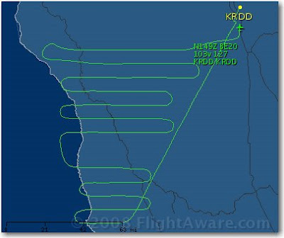
Maps, courtesy of flightaware.com

National fire situation

Six MAFFS C-130 air tankers from the military have now been activated and are based at McClellan airport in Sacramento, CA and at Chico, CA. They are from Charlotte, NC, Colorado Springs, CO, and Cheyenne, WY.

The National Preparedness Level is now 4. This level can be authorized when:

Three or more Geographic Areas are experiencing incidents requiring Type 1 and 2 IMTs. Competition exists between Geographic Areas. Nationally, 60 percent of Type 1 and 2 IMTs and crews are committed.

Weather forecast for northern California

FIRE WEATHER WATCH
NATIONAL WEATHER SERVICE SACRAMENTO CA
948 AM PDT FRI JUN 27 2008

…FIRE WEATHER WATCH FOR DRY LIGHTNING FOR THE INTERIOR MOUNTAINS INCLUDING THE SIERRA NEVADA FOOTHILLS FROM FRIDAY EVENING THROUGH LATE SUNDAY NIGHT..

.HIGH PRESSURE OVER THE DESERT SOUTHWEST IS FORECAST TO BUILD NORTHWARD ACROSS THE GREAT BASIN AND INTO NORTHERN CALIFORNIA FRIDAY AND SATURDAY. THIS WILL CAUSE SUBTROPICAL MOISTURE FROM THE DESERT SOUTHWEST TO SPREAD NORTHWARD OVER THE SIERRA NEVADA ON FRIDAY…AND OVER THE COASTAL RANGE AND NORTHERN MOUNTAINS OF SHASTA COUNTY FRIDAY NIGHT AND SATURDAY. THIS MOIST AND UNSTABLE AIR WILL RESULT IN SCATTERED THUNDERSTORMS OVER THE HIGHER TERRAIN. THE THUNDERSTORMS WILL LIKELY HAVE LITTLE PRECIPITATION ASSOCIATED WITH THEM FRIDAY NIGHT AND SATURDAY. LOW PRESSURE MOVING NORTHWARD ALONG THE CALIFORNIA COAST WILL CONTINUE THE CHANCES OF THUNDERSTORMS ON SUNDAY…WITH STORMS GRADUALLY BECOMING WETTER.

Infrared Aircraft

Both of the U.S. Forest Service infrared line-scanning fixed wing aircraft are working the fires in California and flying out of Redding.

The Ikhana Predator B Unmanned Aerial Vehicle operated by NASA has been ordered and will begin flying fires next week, using it’s equipment to take infrared imagery of the fires and downlink it in real time. Last year it flew missions over fires lasting from 10 to 20 hours before landing.

Update, 11:12 pm, June 27. The Ikhana will fly test flights over the Clover fire on June 28. Their first actual mission will occur July 1 when it will collect imagery over at least 10-12 fires in central and northern California.

Navy and Air Force Global Hawks as well as a U2 airframe will be flying training missions over California on Friday and Saturday.

Fire Summary (Five Day Trend)

Date

Mon

Tue

Wed

Thu

Fri

Day

6/23

6/24

6/25

6/26

6/27

Initial Attack Fires

517

312

406

283

226

New Large Fires

25

14

12

10

6

Large Fires Contained

6

3

8

4

7

Uncontained Large Fires

37

48

52

53

56


The above 5-day summary courtesy of the NPS Morning Report

California: Gallery, Basin, Indians fires

Posted on Categories Uncategorized

Smoke from the Gallery/Basin Fire floats over the coastline.
Photo credit: Pam Balazer, USFS


Basin Complex

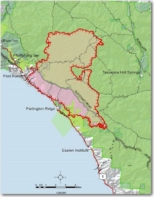
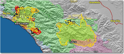
On the Los Padres National Forest south of Big Sur, the Gallery and Basin Fires have officially burned together now. On Thursday the fire continued to burn actively at the higher elevations, exhibiting extreme fire behavior. It continues to back down towards portions of Highway 1, to move south into the South Fork of the Big Sur River drainage, and north towards Manuel Peak. It is 20,763 acres and 3% contained.

Indians fire
Without the smoke from the Basin Complex shading the area, firing operations on the northwest side were initiated with better success on Thursday. It is 59,066 acres and 71% contained.

The map below shows heat, in red, orange, and black, detected by satellites, with the red areas being the most recently burned. The yellow lines are the perimeters uploaded by the incident management teams. Click on the map to see a larger version.

Smokerjumper activity in northern California

The smokejumpers have been busy.

As of 6/25 119 Jumpers Committed to these National Forests in CA:
20 Sierra
30 Shasta Trinity
42 Mendocino
10 Klamath
10 Plumas
7 Six Rivers

Boosters (out-of-area) From:
30 Redmond, OR
30 Missoula, MT
23 McCall, ID
12 Grangeville, ID
9 North Cascades-Winthrop, WA

Total of 104 Boosters
RDD jumpers 38

YTD
31 Fires
182 Jumps

Since June 20
30 Fires
177 Jumps

Weather forecast for northern California

Posted on Categories Uncategorized

Smoke will be another issue this morning, limiting the daytime heating and surface winds during the afternoon hours. However, later this evening and tonight winds will pick up across the far Northern Sacramento Valley and adjacent foothills. These winds will be from the N to NE at 10-20 mph across many exposed areas, along with poor nighttime humidity recovery.

Some areas in the Feather Drainages could see gusts over 35 mph late tonight thru Friday morning. Afterwards, by Friday afternoon all eyes will be on the next thunderstorm outbreak, moving in from the Sierra and shifting NW into much of Northern California through the weekend. Many of these storms could be dry.

(the above, and some of the information below, is from North Ops Predictive Services, 1900, June 25)

What this means for fire behavior-
Since Sunday June 22 the stable atmosphere has not only produced inversions that trapped smoke, but it also slowed down fire behavior due to the resistance to vertical motion and shading from the smoke. When this begins to change Thursday afternoon and Friday there could be a gradual change in venting, and an increase in fire behavior. But in some situations, a major change in rates of spread could occur in as little as 1-2 hours.

What this means for firefighters-
Smoke will lift earlier in the day allowing more options for air operations, and surface winds could become stronger. EXPECT changes in fire behavior. Have lookouts observe changes winds, visibility, and smoke behavior, such as gentle lifting changing to more rapid rising of smoke and faster growing columns.