Don't visit the Lessons Learned Center's or IMT's web sites

Posted on Categories Uncategorized

At least until they rebuild the web sites. Here is an email from Dave Christenson, Assistant Manager at the LLC:

Hello LLC customers,

Our websites have been hacked and redirected to other sites that install a virus code that injects code into our sites and those who come to our sites. This has happened to over 510,000 other websites over the weekend. We can expect to hear from many of our customers concerned about their computers becoming infected with this virus.

We want to help them all by directing them to the link below and advising them to get with their IT folks in order to ensure that they have their sites and computers cleared of the virus code.
See
http://www.f-secure.com/weblog/archives/00001427.html

Best regards,
Dave

There is also a report on wildlandfire.com that the federal Incident Management Teams web site will install a virus on your computer. This is a hellofa thing to do, sabotage federal fire web sites, when we have the Siege of ’08 just getting started. I hope they find and punish the a_holes that are responsible..

Incident Emergency Medical Task Group

Posted on Categories Uncategorized

According to an email from NWCG’s Safety and Health Working Team:

We are pleased to formally announce the creation of the new Incident Emergency Medical Task Group (IEMTG) which has been created under the direction of the NWCG-Safety and Health Working Team. The IEMTG will continue on-going efforts to assist the NWCG and it’s represented agencies in dealing with the complex issues surrounding incident medical and occupational health services.

More information is on their web site.

Dick, thanks for the tip.

DC-10 and 747 air tankers

The DC-10, designated as air tanker 910 and operated by 10 Tanker Air Carrier out of Victorville, California, is on contract for a second year to CalFire. It was used this weekend in northern California on some of the fires in Tehama County. Instead of reloading at Victorville as usual, it filled it’s 12,000 gallon tanks at CalFire’s air tanker base at McClellan. The company is also building a second DC-10 air tanker.

Evergreen International Aviation of Oregon expects to have their 747 air tanker under contract with the U.S. Forest Service within the next 2-5 weeks. It will carry 20,000 gallons and can cruise at mach .85, or 600 mph.

Here is a 19-second video of the DC-10 making a drop on the Humbolt fire near Chico, CA a week or two ago. Turn up the sound so you can hear the audio. The sound of those jet engines from an air tanker will be hard to get used to. When I first started fighting fire, some of the air tankers used the huge radial engines that have a sound you will hear no other place. Another big step was putting turbine engines in the smoke jumper’s DC-3; hard to get used to. Now jets dropping on fires? What’s next? Saturn 5 rockets carrying 1,000,000 gallons of retardant?

Siege of '08, Monday edition

Posted on Categories Uncategorized

The Siege of ’08 will be one for the history books. The map below shows some of the heat, in red, detected by satellites last night from the 911 fires in northern California. Click on it to see a larger version.


HERE is a link to a summary of the fires in northern California. CalFire’s Mendocino Unit had this to say in the remarks:

Multiple fires MINIMAL STAFFING with evacuations in place or imminent: Flynn Creek is 1400 acres, 5% contained and threatening homes; Orr Springs is 200 acres threatening 1 commercial property and approximately 25 residences; Cherry is 180 acres, evacuations of 40 residences and 0% containment; Table is approximately 1000 acres and threatening residences. Heavy resource drawdown is leaving 2/3 of the fires unstaffed. Inaccessible, steep terrain. No Unit coverage, all stations are unstaffed.

The Lime Complex on the Shasta-Trinity reported:

The Lime Complex is comprised of approximately 68 fires ranging in size from one acre to over 400 acres. A number of fires are located in remote areas with steep terrain and limited, or no access. We continue to concentrate on fires that have been initial attacked versus those fires which have not been attacked, and choosing winnable initial attack, or extended attack actions. We are determining resources assigned to each staffed fire.

Projections in the 24 to 72 hour time frames show the community of Hyampom may be surrounded by fire in the 24 hour time range with all ingress and egress severed. A similar forecast holds for the Town of Hayfork in the 72 hour time frame. A critical priority is maintaining the integrity of Highways 3 and 36.

Fire near Big Sur closed coast highway

Posted on Categories Uncategorized

The Gallery fire, now part of the Basin Complex burning south of Big Sur in California, is now reported to be 2,000 acres. Judging from the satellite map below it is at least that big. The coast highway, Highway 1, had been closed by the fire. Now it is closed by a landslide.

The Indians fire, also shown on the map, is 56,044 acres. Yesterday firefighters did some burning out and according to a spokesperson “We had a really good day today”. The heat shown on the map may be their burnout operations. It looks like there is a chance that Bill Molumby and his team may even catch this fire and it won’t be another Los Padres wilderness fire that burns all summer.

Click on the map to see a larger version.

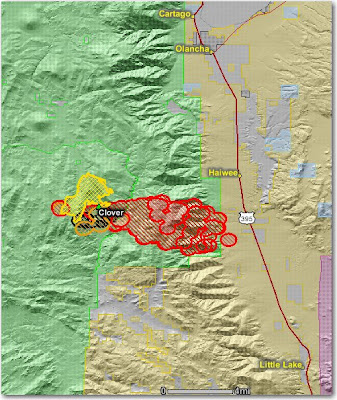
Clover fire approaches Hwy. 395

As we reported yesterday, the Clover fire on the Sequoia National Forest in California, formerly a fire use fire, is now being suppressed. The problem is, it got up and ran yesterday…. big time.

I wonder if the bean counter regrets their decision to release some of the hot shot crews after working only 10 days so they would not have to pay overtime associated with mandatory days off with pay after working the normal 14 days on an assignment? They had planned to re-order the crews in a few days. Now with 911 new fires in the state all competing for resources, they will be lucky to get any orders filled.

The new policy of having U.S. Forest Service bean counters making strategic decisions like this could result in more Clover fires. Fires that actually cost much more than they would otherwise, while burning private land and putting citizens at a greater risk. This is the new “Accountable Cost Management” process. Who is going to be accountable for the Clover fire decisions?

Here is a map of the Clover fire that shows heat detected by satellites last night. Click on it to see a larger version. The yellow line is the last perimeter provided by the incident management team.