Dixie Fire very active Friday near Tobin, California

Updated at 7:08 a.m. PDT July 17, 2021

Map of the Dixie Fire
Map of the Dixie Fire. The white line was the approximate perimeter at 6 p.m. PDT July 16, 2021. The yellow line was the perimeter about 24 hours before. The red areas represent heat detected by a satellite at 3:42 a.m. PDT July 17, 2021. To see a wider zoomed-out view of the area, scroll down.

The updated map of the Dixie Fire west of the Feather River in Northern California shows that it spread northeast for two to three miles Friday and Friday night. At 9:35 p.m. Friday CAL FIRE reported that it had burned 8,754 acres, but it may have grown for another 1,000 acres or so.

The weather forecast for the fire area Saturday afternoon calls for sunny skies and 92 degrees, 10 to 13 mph southwest winds, and relative humidity in the mid-teens. Sunday will look about the same but with partly cloudy skies in the afternoon and a chance of thundershowers in the evening.

(To see all articles on Wildfire Today about the Dixie Fire, including the most recent, click HERE.)

Dixie Fire
Dixie Fire as seen from Bald Mountain, looking east at 7:13 a.m. PDT July 17, 2021.

The Dixie Fire is west of Highway 70 in Feather River Canyon, 13 air miles northeast of Paradise and 24 miles north-northeast of Oroville.


6:42 p.m. PDT July 16, 2021

Map of the Dixie Fire
Map of the Dixie Fire. The white line was the APPROXIMATE perimeter at 8 p.m. PDT July 15, 2021. The red areas represent heat detected by a satellite at 4 a.m. PDT July 16, 2021.

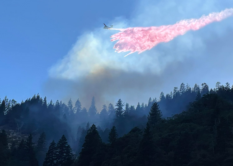
Since the Dixie Fire started at 5:12 p.m. on July 13 near the community of Merlin west of the Feather River in Northern California, it has burned 7,947 acres. As you can see in the satellite photo below it has been very active Friday afternoon, sending a large plume of smoke northwest which may be heavily affecting Chester, Caribou, Westwood, and possibly Susanville.

CAL FIRE reported Friday morning that terrain and winds pushed the fire further north into Tobin Ridge, but the west and south sides of the fire were at that time holding within containment lines.

Satellite Photo, wildfires in Oregon and California
Satellite Photo, wildfires in Oregon and California, 5:17 p.m. PDT July 16, 2021.

The Dixie Fire is west of Highway 70 in Feather River Canyon, 13 air miles northeast of Paradise and 24 miles north-northeast of Oroville.

Resources assigned to the fire Friday morning included 39 hand crews, 10 helicopters, 86 engines, 18 dozers, and 9 water tenders for a total of 1,018 personnel.

Dixie Fire
The Dixie Fire as seen looking east-northeast from Bald Mountain at 6:13 p.m. PDT July 16, 2021.
Aircraft Dixie Fire
An S2T drops on the Dixie Fire in Butte County, California July 13, 2021 shortly after it started. Photo by CAL FIRE.

It looks like an inmate crew got a ride on a Union Pacific Fire Train:

If you want to go down a rat hole to learn more about fire trains, jump in to see all articles on Wildfire Today tagged Fire Train.

Two all-women fire crews at Yosemite and Grand Teton national parks

Funded by a grant from REI Co-op and the National Park Foundation

All women crew
Still image from the video below.

A National Park Foundation grant helped launch a pilot program working with conservation corps in California and Montana to create two women’s fire corps crews in Yosemite and Grand Teton National Parks. Much of the funding is a result of a very large donation from the REI Co-op.

The first video was filmed near the beginning of the fire season and the second checks in on the crews later. To change the resolution of the video, click on the screen-like icon at lower-right.


Update December 3, 2021:
A new video is available about Yosemite’s first Women’s Fire Corps Crew.

So far the drought is far worse than last year

Drought monitor comparison, 2020 & 2021
Drought monitor comparison, similar dates in 2020 & 2021.

As @NOAANCElclimate pointed out, the Drought Monitor shows that the severity of the drought is far worse than it was at about the same date in 2020. Most of the areas in the 11 western states are in Severe, Extreme, or Exceptional Drought.

So far this year the 49 states outside Alaska have burned almost 2.2 million acres, about the same that burned in all of 2019. The 10-year all-year average for those 49 states is 6.4 million acres. In 2020 9.9 million acres burned in the lower 49 states.

Total Wildfire Acres burned 1985-2020

A year-to-date average would be helpful. The National Situation Report gives a number, but unfortunately it includes Alaska which is extremely variable. Fires there can be very large, burning for weeks or months usually with little to no suppression. In the last 10 years the acres burned in Alaska ranged from 181,169 in 2020 to 5,111,404 acres in 2015, with the higher number being 28 times the lower. In 2015 more acres burned there than in the other 49 states combined. Therefore, a year to date average that includes Alaska is virtually meaningless if you want to draw conclusions about the status of the wildfire season in the lower 49 states.

Alaska acres burned
Alaska Acres burned, 2011 – 2020. Raw data from NIFC, processed by Wildfire Today.

Firefighters pulled off sections of the Bootleg Fire

Extreme fire behavior made it too hazardous to remain on the north side

7:40 a.m. PDT July 16, 2021

Bootleg Fire map
Map of the Bootleg Fire. The red areas represent heat detected by a satellite at 3:12 a.m. PDT July 16, 2021. The white line was the perimeter at 7:09 a.m. July 15, 2021.

In Southern Oregon on Thursday firefighters were pulled off some areas of the Bootleg Fire for their own safety. With extreme wildfire behavior causing large fire growth on the north side, it became too hazardous for crews, engines and heavy equipment so they relocated and regrouped.

The southeast side of the fire moved two to four miles east Thursday and crossed into Lake County.

(To see all articles on Wildfire Today about the Bootleg Fire, including the most recent, click HERE.)

Satellite photo showing smoke from wildfires
Satellite photo showing smoke from wildfires at 6:41 p.m. PDT July 15, 2021.

In the video below, retired smokejumper and Bootleg Fire Public Information Officer Jacob Welsh narrates from the front lines Thursday afternoon as equipment was relocating.

An overnight mapping flight determined that the Bootleg Fire had burned over 236,300 acres.

The Incident Management Team is also managing the Log Fire. It was active on its east side Thursday when the gap between the two narrowed to four miles.

Evacuation information for the fire is available HERE.

Pyrocumulonimbus cloud over the Bootleg Fire
Pyrocumulonimbus cloud over the Bootleg Fire July 14, 2021.

Bootleg Fire grows to a quarter of a million acres

17 miles northeast of Klamath Falls, Oregon

Map of the Bootleg Fire
Map of the Bootleg Fire at 10:14 p.m. PDT July 14, 2021.

To say the Bootleg Fire in Southern Oregon was active Wednesday is an understatement. It exhibited extreme fire behavior for hours as winds out of the southwest and west gusted at 15 to 23 mph from 11 a.m. until 10 p.m. while the relative humidity was in the low teens.

I have never seen anything like the satellite photo below. The orange colors are a representation of heat from the very active fire. The eastern two-thirds of Oregon are covered in smoke and a large dark gray oval plume is east of the Bootleg Fire. The white plume stretching to the east appears to be a very, very large pyrocumulus cloud — condensation after the smoke has reached a high altitude. The very unusual feature is the sheer size of the pyrocumulus, which is about 130 miles long.

Bootleg Fire Satellite photo
Bootleg Fire satellite photo at 7:11 p.m. PDT July 14, 2021. GOES 17, NASA.

The fire was mapped at 10:14 p.m. Wednesday at 232,760 acres.

Wednesday evening the Safety Officer and Incident Meteorologist assigned to the Bootleg Fire took the unusual step of issuing a special weather statement to firefighters:

At 8:18 PM PDT, Doppler radar and GOES West Satellite was tracking a pyrocumulonimbus over the Bootleg Fire. Preliminary indications are showing that the smoke plume could possibly collapse over the next hour. Although confidence in the collapse is low, this would be a serious event with strong and quickly shifting winds. Winds in excess of 40 mph will be possible with this collapse. Firefighters and all other persons in and around the Bootleg Fire should prepare for DANGEROUS WEATHER CONDITIONS and seek shelter immediately.

The extreme fire behavior we have been seeing on a regular basis is placing firefighters and the public at increasing risk. Wildland firefighting has always been dangerous, but the “new normal” is a level up on that scale. Firefighters and the public need to recalibrate their thinking about how vegetation fires move across the landscape.

Pyrocumulus clouds, before the last five to 10 years, were not nearly as common as they are today, and are one of the most obvious visual examples of how climate change is affecting wildland fires.

(To see all articles on Wildfire Today about the Bootleg Fire, including the most recent, click HERE.)

The information below about the Bootleg fire is from the Incident Management Team, July 14:

“Power distribution is interrupted in SE Oregon from Fields, OR to Winnemucca, NV with power to pumps supplying agricultural ranches out. There are significant impacts to the CA power grid, causing strain on their power distribution system, which is a very sensitive issue. Smoke has already caused arcing due to the conductivity of the carbon particles in smoke, which impacts power distribution lines well ahead of the fire. Klamath and Lake County Sheriff and Emergency Managers are handling evacuation planning.

“Fire remains very active with significant acreage increases due to hot, dry, breezy conditions, and plume dominated fire behavior. Poor humidity recovery at night is contributing to active fire spread through the night time period. Robust spread rates are being generated by drought effected fuels. Expecting similar conditions for the next several days.

“Although it is predicted to have slightly cooler temperatures in the next couple days, temperatures remain above normal and RH values are expected to be in the lower teens. These conditions paired with gusts winds at times will test control lines, and are expected to contribute to active/extreme fire behavior. Unstable conditions will exist over the area, but smoke thickness will dictate fire weather conditions.”

The weather forecast for Thursday morning in the Beatty, Oregon area calls for 88 degrees, 15 percent relative humidity, and 6 mph winds out of the southwest. After 5 p.m. the wind will be out of the west and northwest at 11 to 14 mph gusting to 21 mph. Another day of active fire behavior.

Red Apple Fire in Chelan County, Washington prompts evacuations of more than 1,000 residences

It has burned approximately 4,000 acres

6:49 p.m. PDT July 14, 2021

Red Apple Fire
Map showing heat detected by a satellite on the Red Apple Fire as late as 2:36 p.m. PDT July 14, 2021 — the red and orange dots. The dark red dots are the most recent.

The Red Apple Fire in Chelan County, Washington north of Wenatchee has prompted evacuation orders (Leave Now) for 1,065 residences.

The homes being evacuated are in the Sunnyslope area of Wenatchee from Highway 2 and Burch Mountain Road to north of Easy Street and American Fruit Road. We are not aware of reports of any homes being destroyed.

The fire is in the wildland-urban interface where flammable vegetation is near dwellings.

It was reported at about 6:55 p.m. Tuesday near Red Apple Road outside Cashmere. The fire quickly grew overnight and was estimated to be about 4,000 acres Wednesday morning.

The blaze was aggressively attacked Tuesday evening but there was not much daylight left that would allow air tankers and helicopters to drop water or retardant.

Red Apple Fire
Red Apple Fire. Tanker 260 reloaded many times in the Columbia River and made water drops on the Red Apple Fire. Map produced at 6:09 p.m. PDT July 14, 2021.

On Wednesday afternoon a flight tracking program noted that within a one hour period multiple helicopters and six air tankers were working on the fire including a DC-10 Very Large Air Tanker and two CL-415 scooping air tankers skimming water from the Columbia River.

Thanks and a tip of the hat go out to Carl.