Incident Management Team releases information about the origin of the Tamarack Fire

The fire crossed US Highway 395 Thursday afternoon

9:10 p.m. PDT July 22, 2021

Tamarack Fire map
Map of the Tamarack Fire July 22, 2021 before it burned across Hwy. 395. The time the data was current is not certain, but may have been early afternoon PDT July 22, 2021.

On Tuesday the Tamarack Fire burned from California into Nevada, and Thursday afternoon it made another big push to the east and hit US Highway 395 with some intensity north of Holbrook Junction. At first it was just a spot fire across the road but it grew very rapidly and at 4:10 p.m. aerial firefighters estimated it had burned 2,500 acres east of the highway.

Several large air tankers including a DC-10 Very Large Air Tanker assisted firefighters on the ground in an attempt to stop the spread of slopover across the highway.

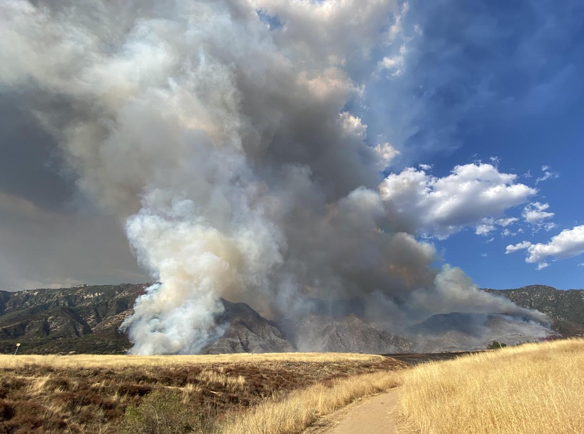
Tamarack Fire crosses Hwy 395
Tamarack Fire crosses Hwy 395 in the afternoon of July 22, 2021. IMT photo.
Tamarack Fire
Tamarack Fire as seen from Hawkins Peak, looking ENE at 9:20 p.m. PDT July 22, 2021.

The Incident Management Team has created an interactive map that at some point is supposed to have evacuation information for residents.


2:32 p.m. July 21, 2021

Tamarack Fire
Tamarack Fire, looking northeast from Hawkins Peak at 2:17 p.m. PDT July 21, 2021.

The Incident Management Team that is suppressing the Tamarack Fire posted on InciWeb their view about how the fire was managed during the first 12 days after it started. The statement was presumably approved by the U.S. Forest Service, the jurisdiction responsible for suppressing and/or managing the fire which was on the Humboldt-Toiyabe National Forest.

“The Tamarack Fire on the Humboldt-Toiyabe National Forest was discovered on July 4,” the statement says. “At the time, 23 other lightning fires were burning.  It was a single tree burning in the Mokelumne Wilderness on a rocky ridgetop with sparse fuels and natural barriers to contain it. The steep, rugged, and remote terrain presented challenges to safely suppress this wilderness fire.  With several higher priority fires in the area and due to the remote location, the sparse fuels and natural barriers, and the concern for firefighter safety, the decision was made to monitor the Tamarack Fire.”

“The Tamarack Fire was monitored daily via air and fire cameras and exhibited very little fire behavior until Friday, July 16 when fueled by extreme winds and low humidity, it progressed rapidly downslope and spread throughout the evening. With this rapid change in the fire, fire resources were dispatched on Friday, July 16. Additional firefighting resources were also ordered, including very Large Air Tankers (VLAT), Single Engine Airtankers (SEATS) and helicopters.”

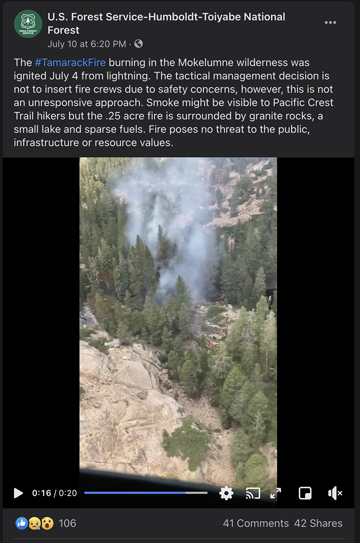
Below is a still image of a Forest Service Facebook post with a video of the fire when it was a quarter acre on July 10, six days after it started. “Fire poses no threat to the public, infrastructure, or resource values,” they wrote.

Tamarack Fire Facebook July 10, 2021

The Tamarack Fire spread further east on Tuesday, crossing the state line from California into Nevada. From its origin, it has now spread 15 miles northeast and 10 miles to the north, burning 10 structures and approximately 40,000 acres.

To see all articles on Wildfire Today about the Tamarack Fire, including the most recent, click HERE.

Gender reveal party that started El Dorado Fire leads to charges for involuntary manslaughter

A wildland firefighter was killed in 2020 while working on the fire that burned more than 22,000 acres in Southern California

El Dorado Fire
El Dorado Fire, photo by Jeff Zimmerman Sept. 5, 2020.

The couple that used a smoke bomb to indicate the gender of their unborn child has been charged with involuntary manslaughter and 29 other crimes, law enforcement officials announced Tuesday.

Investigators found that the El Dorado Fire  was started by a smoke-generating pyrotechnic device at a gender reveal party at a park in Yucaipa, California September 5, 2020. A firefighter was killed on the fire that burned more than 22,000 acres and required the expenditure of nearly $40 million in suppression costs.

Refugio Manuel Jimenez Jr. and Angela Renee Jimenez pleaded not guilty Tuesday, San Bernardino County District Attorney Jason Anderson announced at a news conference.

The couple was also charged with three felony counts of recklessly causing a fire with great bodily injury, four felony counts of recklessly causing a fire to inhabited structures, and 22 misdemeanor counts of recklessly causing fire to property.

The judge released them on their own recognizance even though the prosecutor recommended they each be held on $50,000 bail.

Mr. Anderson said the couple could receive sentences ranging in years from  the low teens to the low twenties.

Charles Morton
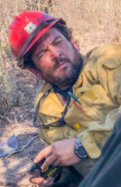
Charles Morton, USFS photo.

The U.S. Forest Service reported that Charles Morton, a 14-year veteran  firefighter, died September 17, 2020 as he was burned over while battling the El Dorado Fire.

Mr. Morton was a squad boss on the Big Bear Interagency Hotshot Crew.

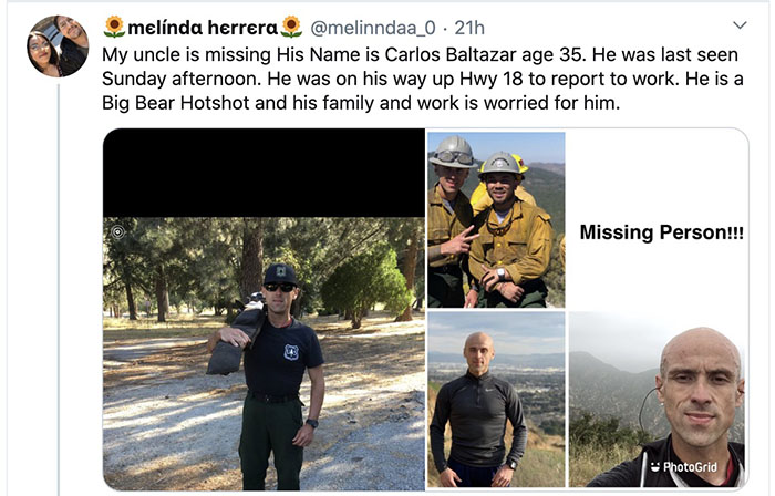
Another Big Bear crewmember disappeared under mysterious circumstances in the days following the death of Mr. Morton. Carlos Alexander Baltazar’s car was found abandoned on Highway 18 near Delta Avenue by the California Highway Patrol on September 20, about 75 yards from his backpack. He was reported missing by his family on September 24. His sister said on the driver’s seat was his ID, a money clip with $200, and on the passenger seat was a knife. His family said he was upset over the death of Mr. Morton, who they described as “his boss.”

As far as we can tell, Mr. Baltazar still has not been found.Carlos Alexander Baltazar

Thanks and a tip of the hat go out to the folks who reported this story to us.

Tamarack Fire spreads east, crosses state line into Nevada

Burns 8 structures and over 50,000 acres

12:42 p.m. PDT July 22, 2021

Tamarack Fire map
Tamarack Fire map. The white line was the perimeter at 8 p.m. PDT July 21, 2021. The green line was the perimeter about 24 hours before.

From the Incident Management Team, Thursday morning, July 22:

There was active fire behavior [Wednesday] afternoon with crowning, short crown runs and prolific spotting as the winds  built up. Fuels remain extremely dry. The fire grew about 10,000 acres [Wednesday] to approximately 50,129 acres. It pushed to Hwy 395 and burned north and south along the highway but did not cross the highway. Active fire also pushed towards, but didn’t cross, Hwy 88 as firefighters were able to keep the fire south of the highway. Hwy 88 & 89 remain closed in the fire area to all traffic except incident personnel. A portion of Hwy 395 closed [Wednesday] for firefighter and public safety.

Over 800 people have been evacuated and over 500 structures are threatened. There are over 1,200 personnel working on the fire and more resources are on order. Firefighting operations continued throughout the night. Night operations include structure protection and firing operations when conditions are right.

The objective for managing the fire is full suppression, and all efforts will be directed towards meeting that objective with public and firefighter safety as the highest priority. Uncontrolled fire with extreme fire behavior continues to be a threat to surrounding communities, public, and firefighters.

Wednesday afternoon the fire was pushed by 15 to 25 mph winds gusting out of the west and southwest up to 33 mph while the relative humidity was in the low teens. The forecast for the east side of the fire Thursday afternoon calls for 82 degrees, 15 percent RH, and 15 mph winds gusting out of the southwest at 24 mph. This could put more pressure on the Highway 395 corridor.

To see all articles on Wildfire Today about the Tamarack Fire, including the most recent, click HERE.
On Friday, conditions will be similar but with winds maxing out at 7 mph from variable directions.

Satellite photo fires in CA WA OR

The National Situation Report for Thursday reduced the number of reported structures destroyed from 10 to 8.

Resources assigned to the fire Wednesday evening included 27 crews, 96 engines, and 9 helicopters for a total of 1,213 personnel.


7:33 a.m. PDT July 21, 2021

Map of the Tamarack Fire
Map of the Tamarack Fire. The white line was the perimeter at 6 p.m. PDT July 20. The Green line was the estimated perimeter about 24 hours before. The red dots represent heat detected by a satellite at 3:18 a.m. PDT July 21, 2021.

The Tamarack Fire spread further east on Tuesday, crossing the state line from California into Nevada (see map above). The fire started July 4 southwest of Markleeville, California and from that point has now spread 15 miles northeast and 10 miles to the north.

After it passed the state line near Leviathan Mine Road it continued east. During a satellite overflight at 3:18 a.m. PDT Wednesday July 21 it was about two miles west of US Highway 395 and 5 miles northwest of the junction of 395 and Highway 208.

Satellite Photo, Dixie and Tamarack Fires
Satellite Photo, Dixie and Tamarack Fires at 6:26 p.m. PDT July 20, 2021.

The Incident Management Team reports that 10 structures have been destroyed.

Tuesday night voluntary evacuations were issued “for all residents in Leviathan Mine Rd. and Holbrook Junction areas.” More information is at InciWeb.

A mapping flight at 6 p.m. PDT Tuesday determined that the fire had burned about 41,800 acres, but it continued burning later into the evening.

Resources assigned to the fire Tuesday evening included 27 hand crews, 99 engines, and 9 helicopters for a total of 1,219 personnel.

Poll: how many fire personnel will be mobilized this year?

Dixie Fire, July 20, 2021
Dixie Fire, July 20, 2021. AlertWildfire.

It’s not even August yet, and the National Interagency Coordination Center’s Incident Management Situation Report showed today that over 19,000 personnel are assigned to wildfires. On Sept. 19, 2020 there were 32,727, the highest number ever recorded.

Will the highest daily number this year be OVER or UNDER that record set last year?

Choose Over or Under in the poll below, then click on the hard to see VOTE button. The poll will close at the end of the day July 31, 2021.


Will the highest number of personnel mobilized at one time for fires this year be OVER or UNDER the record of 32,727 set in 2020?

  • Over (72%, 482 Votes)
  • Under (28%, 192 Votes)

Total Voters: 674

Loading ... Loading ...

Dixie Fire grows to nearly 60,000 acres in Northern California

25 miles north of Oroville

Updated at 7:17 p.m. PDT July 20, 2021

Map of the Dixie Fire
Map of the Dixie Fire. The white line was the perimeter July 19. The red dots represent heat detected by a satellite at 3 p.m. PDT July 20, 2021.

The Dixie Fire 13 air miles northeast of Paradise, California was very active again Tuesday afternoon. The convection column of smoke did not reach the towering heights seen in previous days, probably because the 15 to 20 mph winds recorded at Flea Mountain gusting between 20 and 28 mph mitigated massive vertical development, blowing the smoke rapidly off to the northeast.

(To see all articles on Wildfire Today about the Dixie Fire, including the most recent, click HERE.)

A satellite overflight at 3 p.m. (see the map above) showed large amounts of heat on the north  and northeast sides — north and south of Highway 70. At that time the fire was moving closer to the communities of Twain, Caribou, and Paxton.

Satellite Photo, Dixie and Tamarack Fires
Satellite photo, Dixie and Tamarack Fires at 6:26 p.m. PDT July 20, 2021.
Dixie Fire
Dixie Fire as seen from Bald Mountain, looking NE at 1:23 p.m. PDT July 20, 2021. AlertWildfire.

2:23 p.m. PDT July 20, 2021

Firefighters on the Dixie Fire
Firefighters on the Dixie Fire. Strike Team 9163G looking at a very impressive pyrocumulus cloud, July, 2021. CAL FIRE photo.

The Dixie Fire grew by tens of thousands of acres Monday, reaching 59,984 acres by the end of the day. It now stretches for about 15 miles along the Feather River Canyon and Highway 70, an area known for its steep, barely accessible terrain.

The fire is burning on both sides of the canyon, an area where firefighters have in the past had problems with radio communication caused by the steep slopes.

It is moving to the north and northeast during the day. After sunset Monday, down-canyon winds brought smoke to lower elevations south and southwest of the fire.

Satellite Photo, Dixie Fire
Satellite Photo showing smoke from the Dixie Fire 12:31 p.m. PDT July 20, 2021. NOAA GOES 17.

Evacuation orders are in effect for some areas in Plumas and Butte Counties. A map is available, and CAL FIRE has other evacuation information.

Resources assigned Tuesday morning included 63 hand crews, 23 helicopters, 141 engines, 49 dozers, and 29 water tenders for a total of 2,409 personnel.

The fire has burned very close to communities in Feather River Canyon, including Dixie, Tobin , Belden, Storrie, Rock Creek, and Rodgers Flat. There are reports that at least two structures have been destroyed, but CAL FIRE has not released any information on the topic since the fire started on July 14. Other towns north and northeast of the fire are Caribou, Twain, Paxton, Crescent Mills, and Greenville. Monday night Lake Almanor was about 9 miles northeast of the head of the fire.

Map of the Dixie Fire
Map of the Dixie Fire, showing the location at the end of the day on July 19, 2021. CAL FIRE.

The image below shows a sample of the aircraft that were working on the fire at 1:13 p.m. PDT July 20, 2021. The fire is at upper-right, and the Chico Airport, where some air tankers are reloading, is at lower-left.  Others not seen were flying south to reload at Sacramento McClellan Airport. Observed at this point in time were several helicopters, an MD87, a BAe-146, two S-2Ts, air attack aircraft, and two military C-130s equipped with Modular Airborne FireFighting Systems.

aircraft on the Dixie Fire
Some of the aircraft on the Dixie Fire at 1:13 p.m. PDT July 20, 2021. Flight Radar 24.