Wildland firefighters and mental health

Grassroots Wildland Firefighters issues a statement during Mental Health Awareness Month

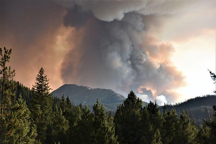
Smoke column from the Williams Fork Fire
Smoke column from the Williams Fork Fire in CO, Aug. 22, 2020. USFS photo.

Grassroots Wildland Firefighters, a new, very active, and increasingly relevant organization has released a statement about mental health:


Mental Health Awareness Month – Time to Shed Light on Federal Wildland Firefighters Most Urgent Challenge

Greater than the acres of treasured forest lands lost, more valuable than any one residential home or business, more challenging than the most complex of wildfire incidents is the challenge of addressing the mental health crisis currently facing the firefighting community. In the Fall of 2019, six current and former federal wildland firefighters came together to discuss and identify what they believed to be major issues plaguing wildland firefighters. Determined to create lasting reforms, they developed solutions critical to protecting and advancing the health and wellness of the men and women who dedicate their lives to such a critical public service.

Mental Health and Wellness is truly at the core of what drives the Grassroots Wildland Firefighters (GRWFF) mission, and they remain steadfast to serve, protect, and support our sisters and brothers; our family.

We’re all here today because we’ve experienced loss in one form or another. We have lost friends in the line of duty. We have lost friends to suicide. We have lost friends to cancer after a lifetime of firefighting. We have buried our friends and colleagues. We have had close calls on the line that shake us to our core. We have responded to medical incidents that involve one of our own. We re-live and revisit these traumatic events never to be forgotten no matter how hard we try to put them aside. We struggle to reconnect with our partners, our children, and our loved ones after being absent from their lives for months on end; missing birthdays, anniversaries and knowing cherished moments are lost. We have struggled with our own demons. We have felt alone.

The Grassroot Wildland Firefighters are here today because of our shared experiences and the invisible bonds we develop. You are not alone. We are listening, and we hear you.

The members of the Grassroots Wildland Firefighters have had the honor and privilege to work in a multitude of positions within the wildland fire community. These experiences have provided our lives purpose, a sense of duty, and incredible opportunity. But it is the extraordinary people with whom we’ve shared these experiences and the lifelong connections we created that have had the largest and most lasting impacts on our lives. They are our brothers and our sisters; they are our family. But deep connections often come at a high cost. And so, when our fire family members are struggling or taken from us too soon, the impact and loss can be immense and often crippling.

The increase in public demand and expectations placed on Wildland Firefighters to respond to ever larger and more intense wildfires is far from abating, and, as a matter of fact, is expected to exponentially increase in the coming years. Our federal Wildland Firefighter workforce is currently experiencing a major decline in frontline fire experience, advanced leadership qualifications, and severe staffing shortages not seen in recent memory.

Coming out of a pandemic during one of the worst fire seasons in history puts us in a position of incredible stress and strain on our personal mental health and wellness. The physical fire environment is outpacing our ability to think and act creatively.  For our federal wildland fire workforce, we are outmatched and outpaced with the social and political demands that are expected of us. This places an untenable burden on the federal wildland firefighting response community. The GRWFF recognizes this burden impacts not only us, but the partners and families we leave behind.

We are reaching out to our fire family during Mental Health Awareness Month to reaffirm our commitment to the wildland fire community.  As we progress as an organization, so too does our commitment to the comprehensive Health and Wellbeing of our federal fire workforce.

As the GRWFF Comprehensive Health and Wellbeing subcommittee gathers data and research on the topic of mental health, we also continue to develop our resources page on the GRWFF website.  We are working with several other non-governmental organizations to provide data, research, stories, and resources to help raise awareness and propose much needed reforms.

We recognize these problems are complex, but we are committed to identifying the true source of these issues and developing and implementing real solutions through legislative efforts to further support our fire family.  We are all in this together.

Large wildfires in Manitoba prompt smoke advisories

Manitoba fires map
Map showing the locations of wildfires in Southern Manitoba at 5:12 a.m. CDT May 18, 2021. Based on heat detected by satellites.

Multiple wildfires in Southern Manitoba grew large Monday pushed by strong winds while the temperature was high and the relative humidity was low. The smoke being produced by the blazes prompted Environment Canada to issue multiple special air quality statements Monday evening.

“Localized areas of smoke are creating reduced visibilities and poor air quality down wind of fires,” the agency said in the statement.

Satellite photo of smoke from Manitoba wildfires
Satellite photo of smoke from Manitoba wildfires, May 17, 2021.

The areas under the air quality statement as of Monday evening include:

  •  Whiteshell – Lac du Bonnet – Pinawa
  •  Arborg – Hecla – Fisher River – Gypsumville – Ashern
  •  Bissett – Victoria Beach – Nopiming Provincial Park – Pine Falls
  •  Brandon – Neepawa – Carberry – Treherne
  •  Dauphin – Russell – Roblin – Winnipegosis
  •  Dugald – Beausejour – Grand Beach
  •  Grand Rapids – Waterhen
  •  Selkirk – Gimli – Stonewall – Woodlands
  •  Ste. Rose – McCreary – Alonsa – Gladstone

Four 10-person teams of firefighters are being brought in from Ontario to assist, while Quebec sent two air tankers and a bird dog aircraft.

Ontario firefighters en route Manitoba fire
Ontario firefighters en route to assist with wildfires in Manitoba May 15, 2021. Photo by Ontario Ministry of Natural Resources.

The EA044 fire 23 Km (14 miles) west of Gypsumville seen on the map above is very close to another much larger fire. They may be all one fire separated by an area of light vegetation that cooled in between heat-detecting satellite overflights. If they are one, they cover an area of approximately 52,500 hectares (130,000 acres). About 28,300 hectares (70,000 acres) burned at that location Monday during the strong winds.

Below are forecasts produced by FireSmoke Canada for the distribution of wildfire smoke on Tuesday and Thursday. The circles with numbers indicate multiple fires at each location.

Wildfire northeast of Bass River, NJ burns over 600 acres

Ballanger Fire New Jersey
Ballanger Fire. Photo by NJ Forest Fire Service May 16, 2021.

A fire that started May 16 in Eastern New Jersey burned 617 acres before firefighters from several departments in Ocean and Burlington Counties stopped the spread at 10 a.m. on May 17. The blaze is about three miles northeast of Bass River, between the Garden State Parkway and US Route 9.

To contain the fire, crews conducted burnout operations on Stage Road, Otis Bog Road, Munion Field Road, and along US Route 9. Firefighters also constructed firelines to secure some of the 30 homes that were threatened.

Map of the Ballanger Fire
Map of the Ballanger Fire near Bass River, NJ.

The fire consumed approximately 243 acres on the Bass River State Forest and 374 acres of private land.

The resources included 13 Type 6 Engines (Brush Trucks), 1 bulldozer, 1 Water Tender, 1 helicopter (observation), and 8 cooperative fire engines.

Ballanger Fire New Jersey
Ballanger Fire. Photo by NJ Forest Fire Service May 16, 2021.

Secretary of Agriculture holds Wildland Fire Town Hall with employees

US Forest Service headquarters in Washington
US Forest Service headquarters in Washington.

Secretary of Agriculture Tom Vilsack hosted a virtual “Wildland Fire Town Hall Meeting” Monday. The Forest Service was apparently expecting a large number of employees to attend and established a 10,000-person limit on the Zoom platform.

Here is how the meeting was described in an email sent to Forest Service personnel:

Employees representing fire operations, leadership, research, and wildfire support operations are invited to engage in a conversation with Secretary Vilsack and Chief Christensen. This meeting is intended to be a focused and intimate dialogue with employees from the wildland fire community across the agency, however all employees are invited. There is a limit of 10,000 participants.

Chief Christensen will welcome wildland fire employees, speaking to the risks and leader’s intent for the fire year. Secretary Vilsack will share his leader’s intent on a variety of issues that include extended fire seasons, fire and climate change, wildfire response during COVID 19, and an inclusive workplace environment that focuses on employee safety and well-being. Employees will have an opportunity to share their fire experiences with the Secretary and ask questions.

The meeting was not open to the public but some of those who attended told Wildfire Today that there were about 15 people on the screen who may have had the ability to speak including the Secretary and Forest Service Chief Vicki Christiansen. Others represented jobs such as Fire Management Officer, Research Ecologist, Wildland Fire Module Captain, Fuels Specialist, Helitack Captain, and Fire Staff Officer on a Forest.

Tom Vilsack
Sec. of Agriculture Tom Vilsack

The individuals that spoke introduced themselves and described their job, sometimes at great length, and then asked the Secretary a question.

The subject of converting seasonal employees to permanent came up at least twice. Climate change, the competitive job market, a diverse workforce, work-life balance, and mental health were other topics discussed according to our sources.

If you attended the event and would like to add more information or have an opinion about the usefulness of a virtual town hall meeting like this, let us know in a comment below, or at the top of the article click on “Leave a comment” or “Comment.”

UPDATE May 18, 2021. We found out today that Secretary of the Interior Deb Haaland hosted a similar wildland fire management town hall on the same day as Secretary Vilsack’s.

Sheriff’s office searching for arsonist at Palisades Fire in SoCal

A suspect was arrested Sunday afternoon

Updated at 5:01 p.m. PDT May 17, 2021

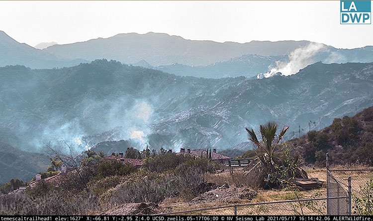
Palisades Fire
Palisades Fire, looking northwest from Temescal Trailhead at 4:14 p.m. PDT May 17, 2021.

The Los Angeles Fire Department announced Monday morning that an adult male suspected of igniting the Palisades Fire was detained, questioned and then arrested Sunday afternoon by LAFD Arson Investigators. Ralph M. Terrazas, Chief of the Los Angeles Fire Department said in a 10 a.m. press conference on Monday that personnel in a Police Department helicopter observed the ignition of the fire, as well as a second ignition later but lost sight of him in the smoke and dense brush. The suspect was treated Sunday for smoke inhalation.

The intensity and spread of the fire slowed considerably Sunday night and Monday. As predicted, the visibility improved Monday afternoon enough to allow the use of three fixed wing air tankers which dropped retardant to assist firefighters on the ground. They supplemented the work being done by helicopters that have been dropping water. The fire has burned 1,325 acres.

There has been no change in the existing Mandatory Evacuation orders in the County of Los Angeles or the Evacuation Warning in the City of Los Angeles.

No structures have been damaged. One firefighter sustained a minor injury.


Updated at 9:52 p.m. PDT May 16, 2021

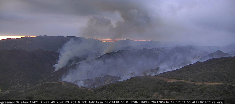
Palisades Fire May 16, 2021
Palisades Fire, looking west from Green Peak at 7:17 p.m. PDT May 16, 2021.

The active investigation into the cause of the Palisades Fire continues. Arson investigators from the Los Angeles Fire Department detained and released one individual, but at 6 p.m. PDT they announced that they are questioning a second person.

The latest information about the fire puts it at 1,325 acres, but these fire updates have been running many hours behind the actual fire activity.

The weather will turn against the firefighters Monday afternoon when the wind out of the southwest will increase to 10 mph and gusts to 16 mph, with relative humidity dropping into the 50s. The cloud cover will decrease after 11 a.m. which may allow the use of fixed wing air tankers.


Updated at 4:04 p.m. PDT May 16, 2021

LA County helicopter departs 69Bravo Palisades Fire
LA County helicopter departs 69Bravo heading toward the Palisades Fire at 11:59 a.m. PDT May 16, 2021. AlertWildfire photo.

At 3:05 p.m. Sunday the Los Angeles Fire Department reported that the Palisades Fire near Topanga, California was mapped at 1,325 acres.

The Department issued a warning at 2 p.m. Sunday for residences in a portion of The Summit community to be ready to evacuate.

An Evacuation Warning is now in effect for the following area (as shown on the map above): Starting at the 1500 block of Chastain Parkway W – all homes north of Chastain Parkway over to Calle Del Cielo (eastern boundary). The warning area includes Calle De Sarah, Calle Bellevista and all homes West of Calle Del Cielo / Ave Ashley up to the hills.

All residents in this area are asked to prepare for a potential evacuation based on the developing fire activity. Secure your valuables, medicines, etc in your car and be prepared if asked to evacuate.


Evacuation warning The Summit
Evacuation warning The Summit, at 2 p.m. May 16, 2021. LAFD map.

The visibility over the fire is not adequate to allow the use of fixed wing aircraft, but helicopters are still assisting firefighters. Departments that sent helicopters include LA FD, LA County, Ventura County, and Orange County.


12:01 p.m. PDT May 16, 2021

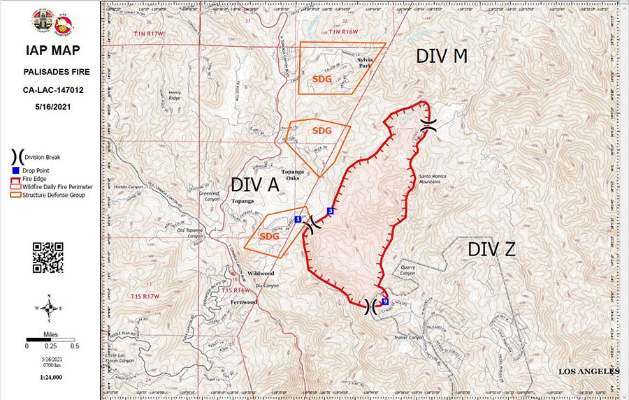
Palisades Fire Map
Palisades Fire Map, released Sunday morning May 16, 2021. By LA Co. FD, and LA FD.

No structures have been damaged. One firefighter sustained a minor injury. There are no reported injuries to any civilians.

Continue reading “Sheriff’s office searching for arsonist at Palisades Fire in SoCal”

Palisades Fire is burning northwest of Santa Monica, California

The fire is in Topanga State Park

Updated at 9:23 p.m. PDT May 15, 2021

Palisades Fire map
Map showing the approximate location of the Palisades Fire (the large red arrow) at 7 p.m. MDT May 15, 2021. It is spreading north-northwest.

(To see all articles on Wildfire Today about the Palisades Fire, including the most recent, click HERE.)

Authorities have ordered evacuations for some areas near Topanga as the Palisades Fire continues to spread north-northwest from The Summit community toward Topanga in Southern California. (see map of the Palisades fire above)

The evacuations affect locations east of Topanga Canyon Boulevard between Topanga Community Center and Viewridge Road, as well as those north of Entrada Road, south of Oakwood Drive and east of Henry Ridge Mountain Way.

The fire crossed the Topanga Fire Road at about 7 p.m.  At that time Air Attack orbiting over the fire estimated it had burned more than 750 acres.

Palisades Fire
Palisades Fire looking NE from 69Bravo Helistop at 8:19 p.m. PDT May 15, 2021.

The only bit of good news is the relative humidity will increase Saturday night from the mid-80s to 100 percent along with a 24 percent chance of 0.02 inch of rain. On Sunday afternoon the chance of precipitation decreases to 10 percent and the relative humidity will drop to 60 percent — still high to support the spread of a typical Southern California vegetation fire, but the 60 year old brush near Topanga is showing it can burn in high humidity during the extreme drought currently affecting the area.

The Palisades Fire started in the city limits of Los Angeles, but appears likely to spread into Los Angeles County, if it hasn’t already.


Updated at 6:30 p.m. PDT May 15, 2021

Palisades Fire
Map showing the approximate location of the Palisades Fire in Topanga State Park, May 15, 2021.

The Palisades Fire was reported at about 10 p.m. Friday 5 miles northwest of Santa Monica, CA in Topanga State Park. (See map above.) The blaze is less than a mile north of The Summit, a gated community of upscale homes.

At 5:20 p.m. PDT Saturday firefighters estimated it had burned 150 to 200 acres.

A 10 mph wind out of the south is pushing the fire up hill to the north into a remote area that is difficult for firefighters to access. It is moving at moderate rate of spread, which is faster than I would expect considering that the relative humidity near the fire at Green Peak was high, 79 percent at 5:16 p.m. PDT.

LA County Helicopter 14, a Bell 412 Palisades Fire
LA County Helicopter 14, a Bell 412, refilling at 69Bravo during the Palisades Fire, 5-15-2021

It is spreading through vegetation that has not burned in at least 60 years, according to records from the National Interagency Fire Center. This buildup of old, possibly decadent brush helps explain how it’s burning so well while the RH is high. Live fuel moisture may also be a factor.

Several helicopters and at least a half dozen fixed wing air tankers worked on the blaze until about 6 p.m. when the tankers had to be shut down due to poor visibility. The helicopters will continue to drop water through the night, unless the visibility gets even worse.

MyNewsLA reported that members of the sheriff’s Special Enforcement Bureau were searching for a person suspected of setting the fire. The search was confirmed by Deputy Alejandra Parra of the Sheriff’s Information Bureau.

We will update this article as more information becomes available.

Palisades Fire
Palisades Fire as seen from Green Peak, looking northwest at 4:41 p.m. PDT May 15, 2021.
Palisades Fire
Palisades Fire as seen from 69Bravo Helistop, looking northeast at 4:38 P.M. PDT May 15, 2021.