Members of Congress call for increased support for wildfire preparedness

Warehouse at the National Interagency Fire Center
Warehouse at the National Interagency Fire Center. Screenshot from NIFC video.

On June 15 Congressman Jimmy Panetta (CA-20) led 18 members of Congress in the California Delegation in calling on House leadership to ensure that any future legislative package focused on infrastructure, economic stimulus, and job creation include robust funds to address deferred maintenance and wildland fire preparedness needs in the U.S. National Forest System.

“For a long time, the U.S. Forest Service has not received sufficient funding to adequately complete its necessary infrastructure projects.  That backlog increases the threat to communities across the Forest Service’s Pacific Southwest region, including California, as we move into the 2020 wildfire season,” said Congressman Panetta.  “As Congress considers legislation for infrastructure, economic stimulus, and job creation, we must fight for more funding for Forest Service projects that will not only generate jobs, but also give our federal firefighters the necessary tools to prepare for wildfires and keep our communities safe.”

“It is important to note that the current backlog of projects in the USFS Pacific Southwest Region is particularly concerning as the state of California progresses deeper into its 2020 wildfire season, with fire officials predicting higher-than-normal fire potential through the fall.  As the Region works to swiftly implement new wildfire suppression tactics to reduce the risk of COVID-19 spread at base camps, it is all the more important that USFS employees have access to working infrastructure,” the members wrote.

The text of the letter sent to Speaker of the House Nancy Pelosi and Minority Leader Kevin McCarthy is below:


June 15, 2020

Dear Speaker Pelosi and Leader McCarthy:

As Congress works to develop and disburse immediate relief to communities impacted by the COVID-19 pandemic, we must also consider the investments needed to bring tens of millions of people back to work to rebuild a stronger, more sustainable economy. To this end, we write to you to ensure that any future legislative package focused on infrastructure, economic stimulus, and job creation include robust funds to address deferred maintenance and wildland fire preparedness needs in the U.S. National Forest System.

Since the onset of the COVID-19 pandemic, communities across our nation have turned to National Forests as spaces to safely spend time outdoors while adhering to Centers for Disease Control (CDC) physical distancing guidelines. Additionally, U.S. Forest Service (USFS) roads and bridges are playing a key role in ensuring rural communities can safely reach grocery stores and hospitals during the pandemic. At the same time, our National Forest System is suffering from $5.2 billion worth of backlogged repairs for roads and road bridges, trails, and facilities, which far exceeds the $446 million included in the fiscal year 2019 USFS budget for infrastructure improvement and maintenance.

In the USFS Pacific Southwest Region, which includes eighteen national forests spanning 20 million acres of land in California, a recent Regional review identified over 90 deferred maintenance projects with critical safety components for administrative facilities, fire facilities, and employee housing, including five priority projects on each National Forest in the state. Completion of these projects would reduce maintenance costs, improve visitor experiences, support employee recruitment and retention, and allow for additional modifications needed to protect employees, particularly in light of COVID-19. Notably, funding these projects would also create hundreds of jobs across the state.

It is important to note that the current backlog of projects in the USFS Pacific Southwest Region is particularly concerning as the state of California progresses deeper into its 2020 wildfire season, with fire officials predicting higher-than-normal fire potential through the fall. As the Region works to swiftly implement new wildfire suppression tactics to reduce the risk of COVID-19 spread at base camps, it is all the more important that USFS employees have access to working infrastructure.

To keep these federal employees and the rural communities they serve safe, we urge you to provide funding for the design and construction of new fire cache facilities and updated airtanker bases throughout the state. By replacing the debilitated and aging Northern and Southern Operations Geographic Area Caches, the USFS Pacific Southwest Region would be able to significantly reduce leasing costs and increase wildfire preparedness. Similarly, by updating the infrastructure at airtanker bases, the USFS would be able to generate jobs, more rapidly deploy large airtankers to the fire line, and enhance initial attack effectiveness to protect communities and firefighters.

In addition to prioritizing the aforementioned physical infrastructure projects, we urge you to include funding for technology updates needed to provide real-time tracking and response of firefighting resources, particularly during rapidly escalating wildfires. With upgraded information technology, firefighting teams will not only be able to virtually access weather and other incidental information but also share information in real time with other firefighting teams. This type of collaboration will significantly enhance the common operating picture for all levels of a firefighting organization.

For decades, the USFS has struggled with insufficient funds to address critical infrastructure needs, and every year, the backlog of projects becomes increasingly overwhelming. As the COVID-19 pandemic puts new and unknown pressures on our National Forest System, we cannot wait any longer to prioritize these projects.

Over the coming weeks, as you work to make critical funding decisions to address the current unemployment crisis, we ask that you strongly consider the high potential for USFS projects in the Pacific Southwest Region to create thousands of sustainable jobs, particularly during a time of heightened need for effective USFS services. As the Pacific Southwest Region has already completed a comprehensive review of projects, we encourage Congressional investments directly to the Region so these projects can move forward in a timely manner.

Sincerely,

Jimmy Panetta
Member of Congress

Maps of the Bush Fire northeast of Phoenix

Maps of the Bush Fire, northeast of Phoenix.

(UPDATED at 1:21 p.m. MDT June 21, 2020)

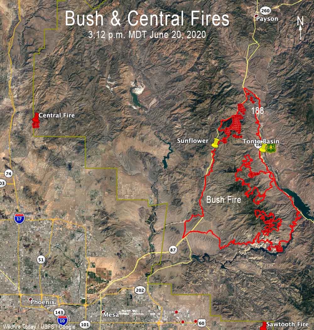
Central and Bush Fires Phoenix
The Central and Bush Fires in the Phoenix Area, June 21, 2020.

(UPDATED at 10:52 a.m. MDT June 20,2020)

Friday night’s mapping flight determined that the Bush Fire had burned 174,397 acres, an increase of 23,397 acres in 24 hours.

For all articles on Wildfire Today about the Bush Fire northeast of Phoenix including the most recent, click here.


(UPDATED at 8:23 a.m. MDT June 19, 2020)

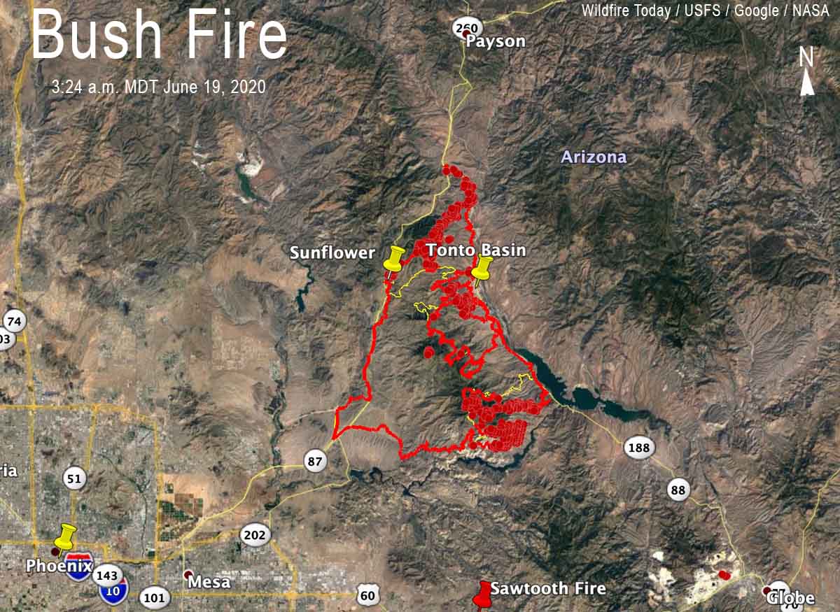
Bush Fire map June 19, 2020 wildfire Arizona Phoenix Jakes Corner
The red line was the perimeter of the Bush Fire detected by a mapping flight at 11:18 p.m. MDT June 18. The yellow line was the perimeter detected by a mapping flight at 11:49 p.m. MDT June 17. The red dots represent heat detected by a satellite at 3:24 a.m. MDT June 19.

The fire has grown to 151,075 acres.


(UPDATED at 8:04 p.m. MDT June 18, 2020)

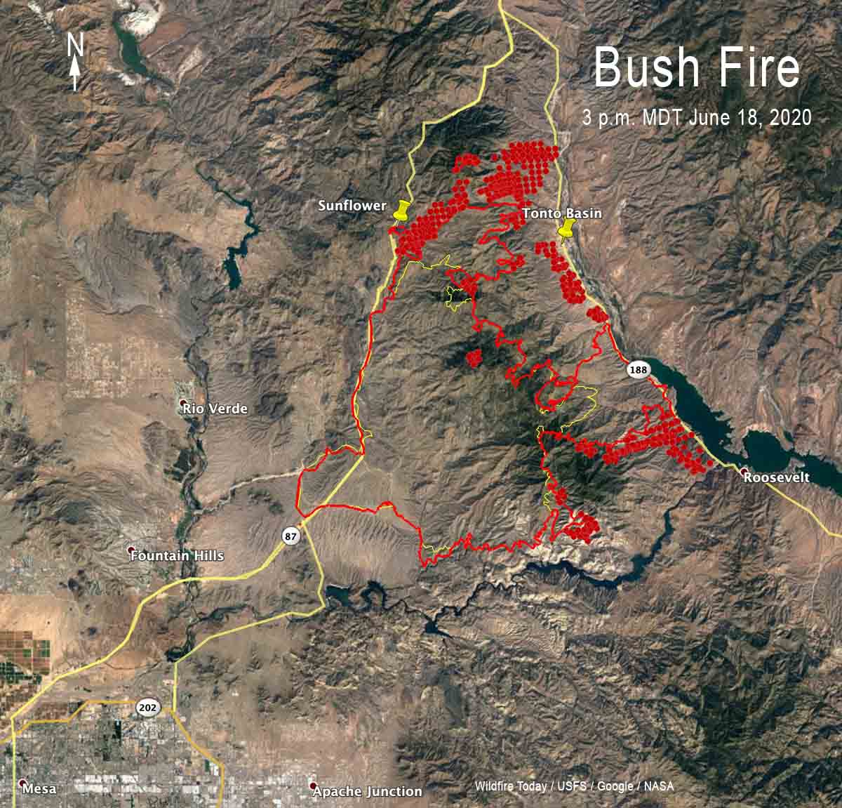
Bush Fire map 3 pm MDT June 18, 2020 wildfire Arizona Phoenix
The red line was the perimeter of the Bush Fire detected by a mapping flight at 11:49 p.m. MDT June 17. The yellow line was the perimeter detected by a mapping flight at 11:12 p.m. MDT June 16. The red dots represent heat detected by a satellite at 3 p.m. MDT June 18.

(UPDATED at 7:42 a.m. MDT June 18, 2020)

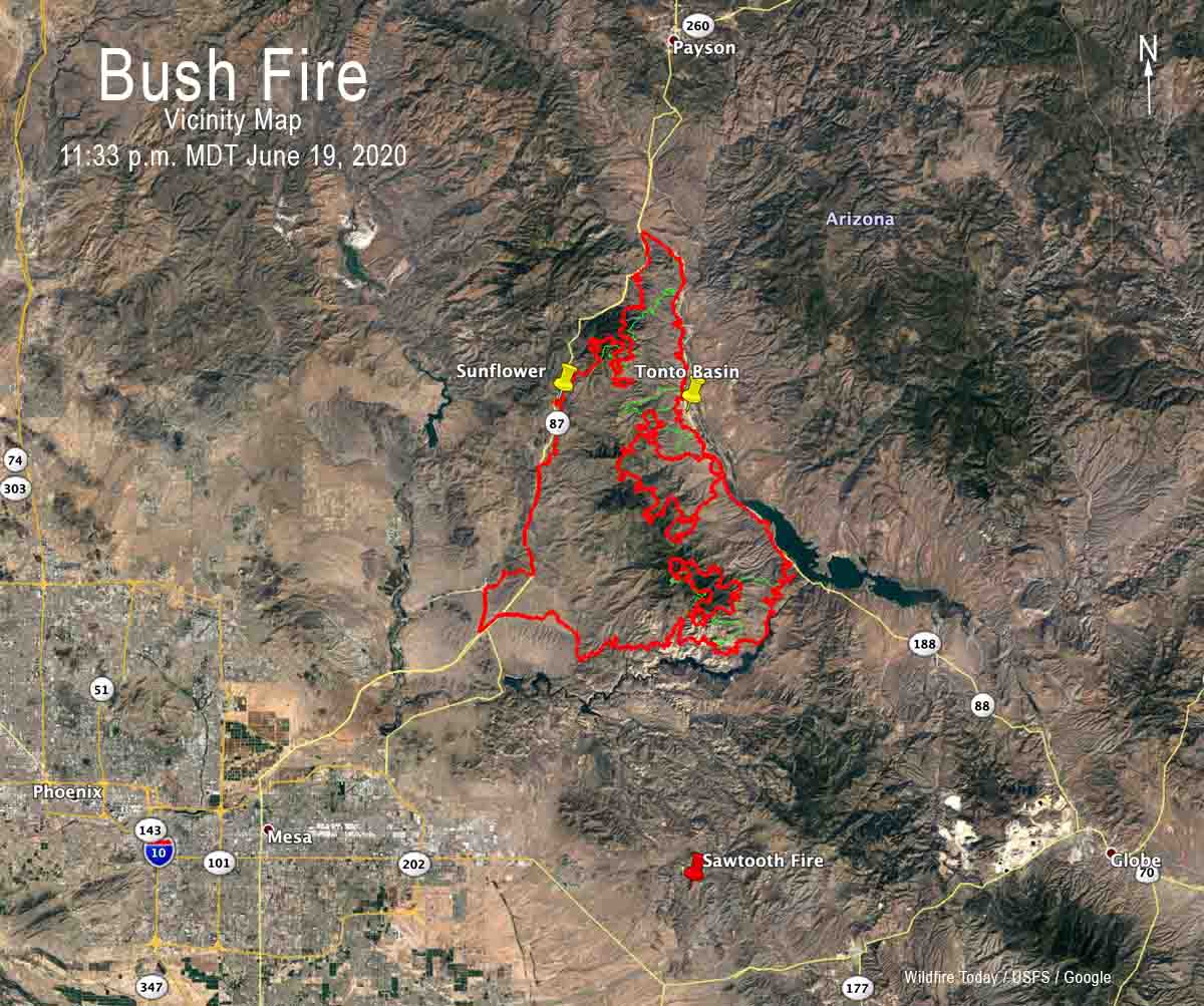
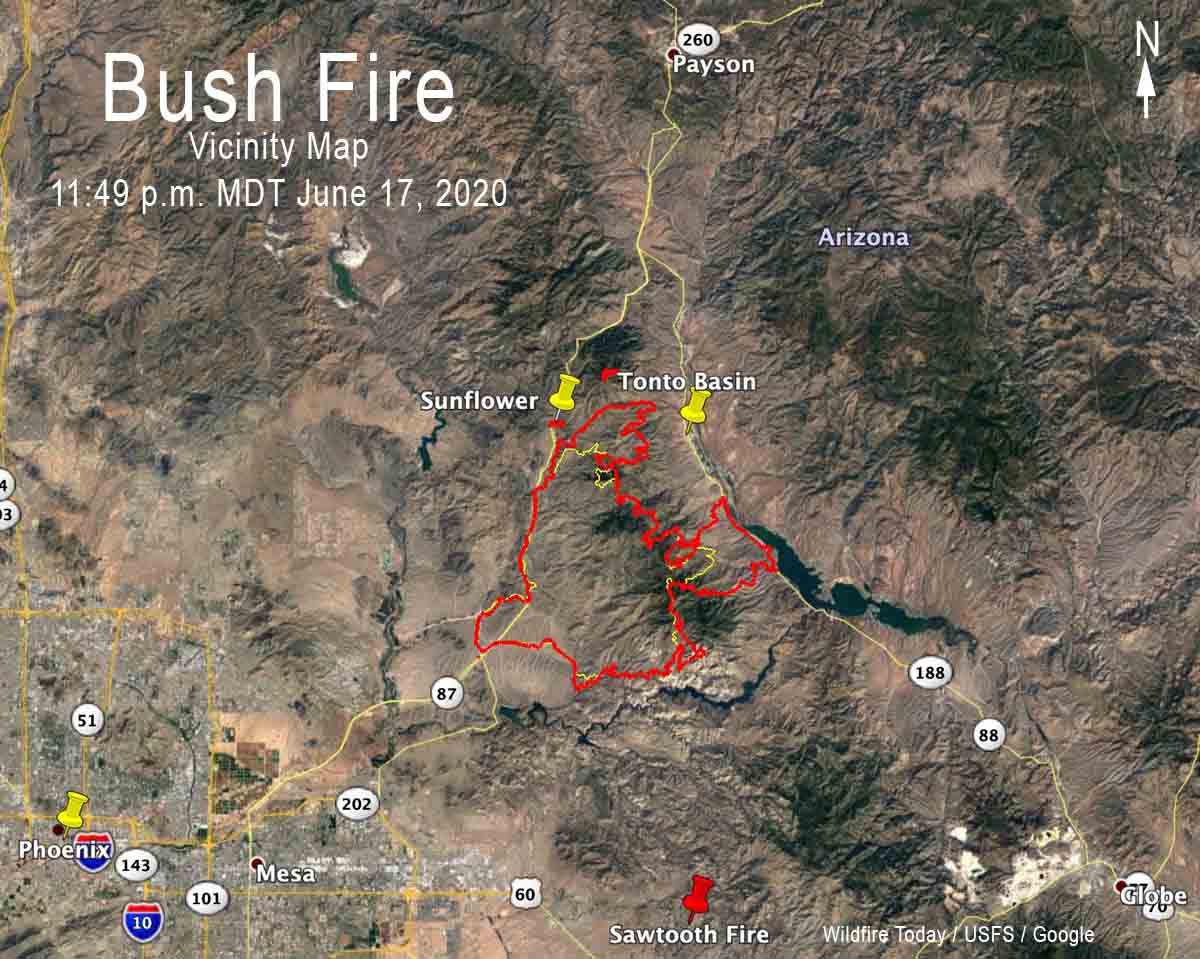
Bush Fire Vicinity Map
Vicinity map for the Bush Fire, 11:49 p.m. MDT June 17, 2020.
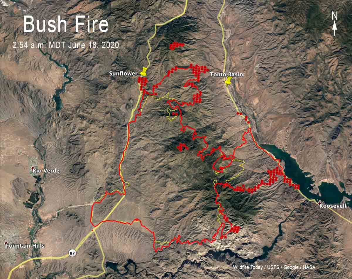
Bush Fire Map 254 am MDT June 18, 2020
The red line was the perimeter of the Bush Fire detected by a mapping flight at 11:49 p.m. MDT June 17. The yellow line was the perimeter detected by a mapping flight at 11:12 p.m. MDT June 16. The red dots represent heat detected by a satellite at 2:54 a.m. MDT June 18.

For all articles on Wildfire Today about the Bush Fire northeast of Phoenix including the most recent, click here.


(UPDATED at 7:25 p.m. MDT June 17, 2020)

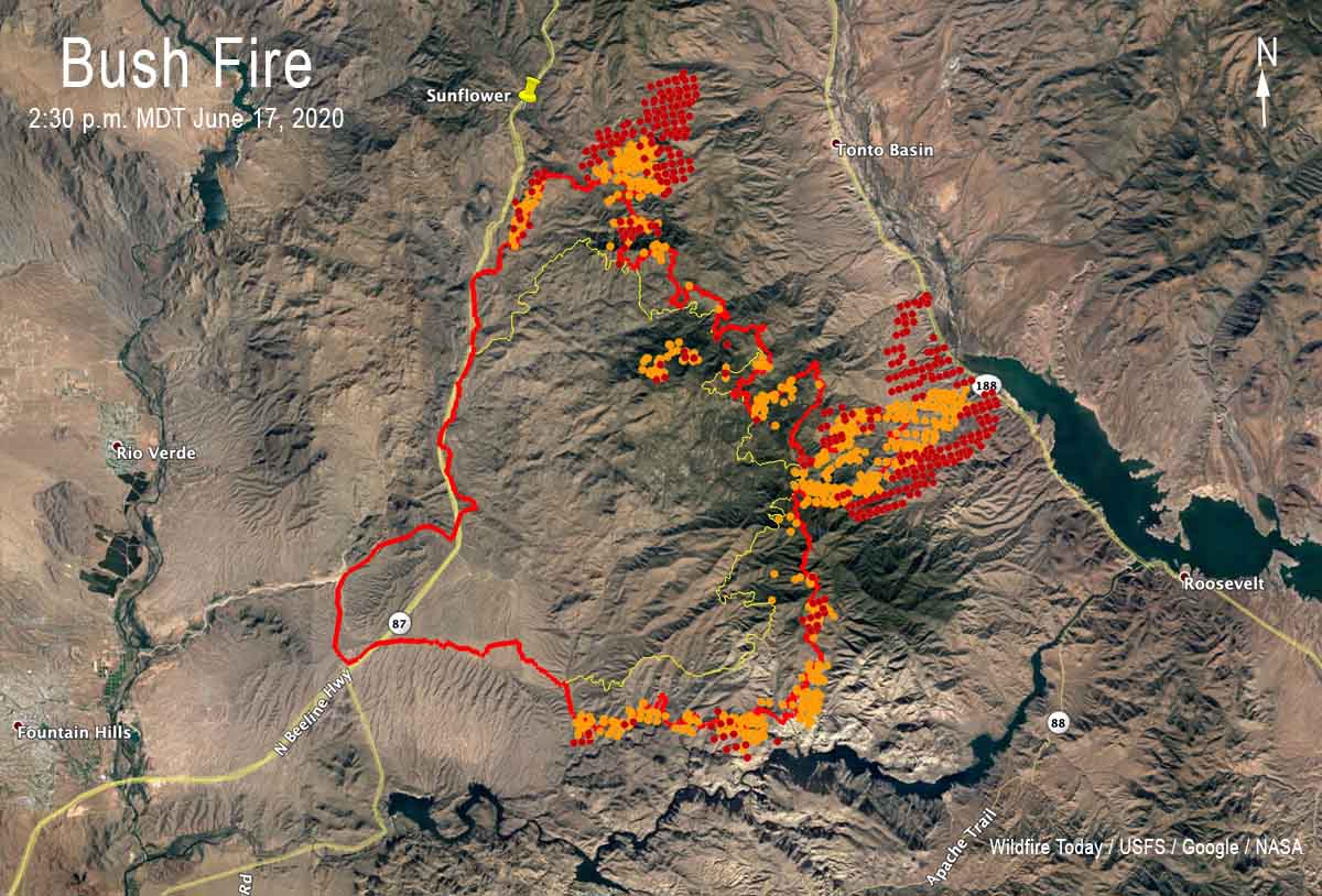
Bush Fire map Phoenix
The red line was the perimeter of the Bush Fire detected by a mapping flight at 11:12 p.m. MDT June 16. The yellow line was the perimeter detected by a mapping flight at 12:45 a.m. MDT June 16. The orange and red dots represent heat detected by a satellite on June 17.

(UPDATED at 9:20 a.m. MDT June 17, 2020)

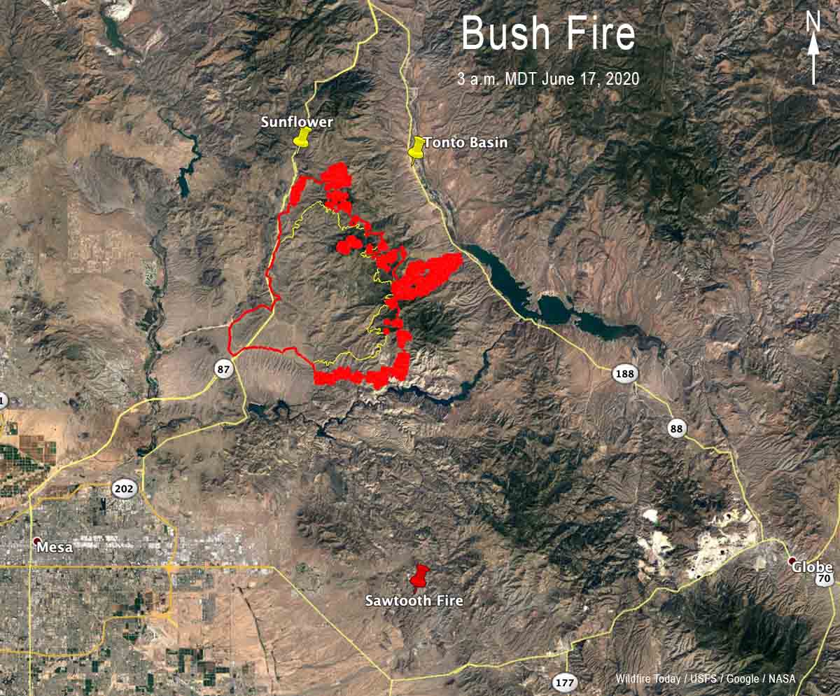
Map of the Bush Fire
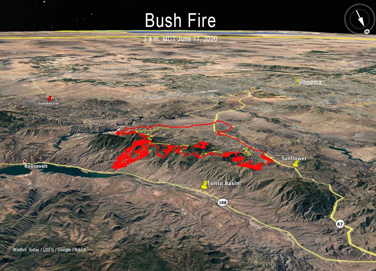
Map of the Bush Fire at 3 a.m. MDT June 17, 2020. Data from USFS mapping flight and NASA satellites.
Map of the Bush Fire
3-D map of the Bush Fire at 3 a.m. MDT June 17, 2020. Data from USFS mapping flight and NASA satellites.

For all articles on Wildfire Today about the Bush Fire northeast of Phoenix including the most recent, click here.

map Bush Fire Arizona Phoenix
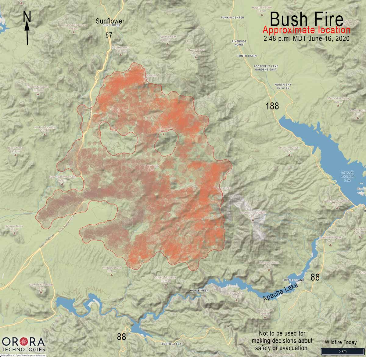
Map showing the approximate location of the Bush Fire at 2:28 p.m. MDT June 16, 2020. It is based on heat detected by satellites. This unofficial map should not be used to make decisions about safety or evacuation.
north side of the Bush Fire
Map showing the approximate location of the north side of the Bush Fire at 12:50 pm MDT June 16, 2020.
Bush Fire map Phoenix Arizona 3-D
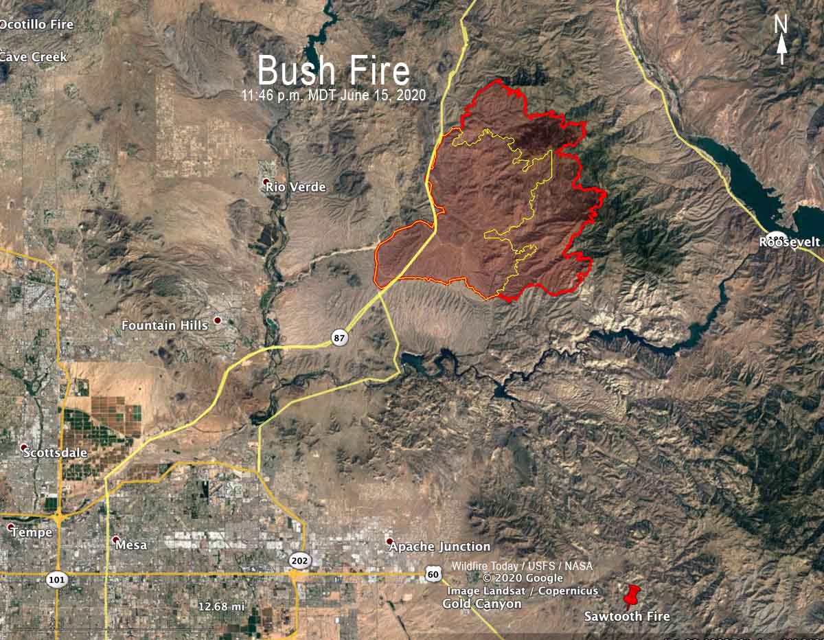
3-D map showing the perimeter (in red) of the Bush Fire looking northeast at 11:46 p.m. MDT June 15, 2020. The yellow line was the perimeter 24 hours before.
Bush Fire map Phoenix Arizona
Map showing the perimeter of the Bush Fire (in red) at 11:46 p.m. MDT June 15, 2020. The yellow line was the perimeter 24 hours before.

A mapping flight Monday night at 11:46 determined that the Bush Fire had burned 64,513 acres.

satellite photo Bush Fire northeast of Phoenix
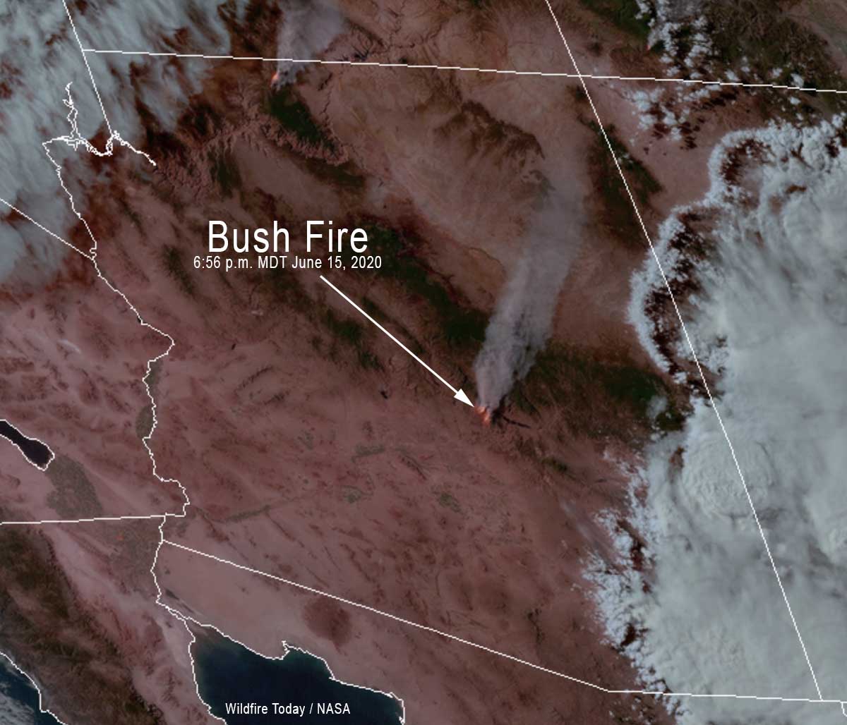
GOES-17 satellite photo of the Bush Fire northeast of Phoenix at 6:56 p.m. MDT June 15, 2020.
3-D Map of the Bush Fire northeast of Phoenix
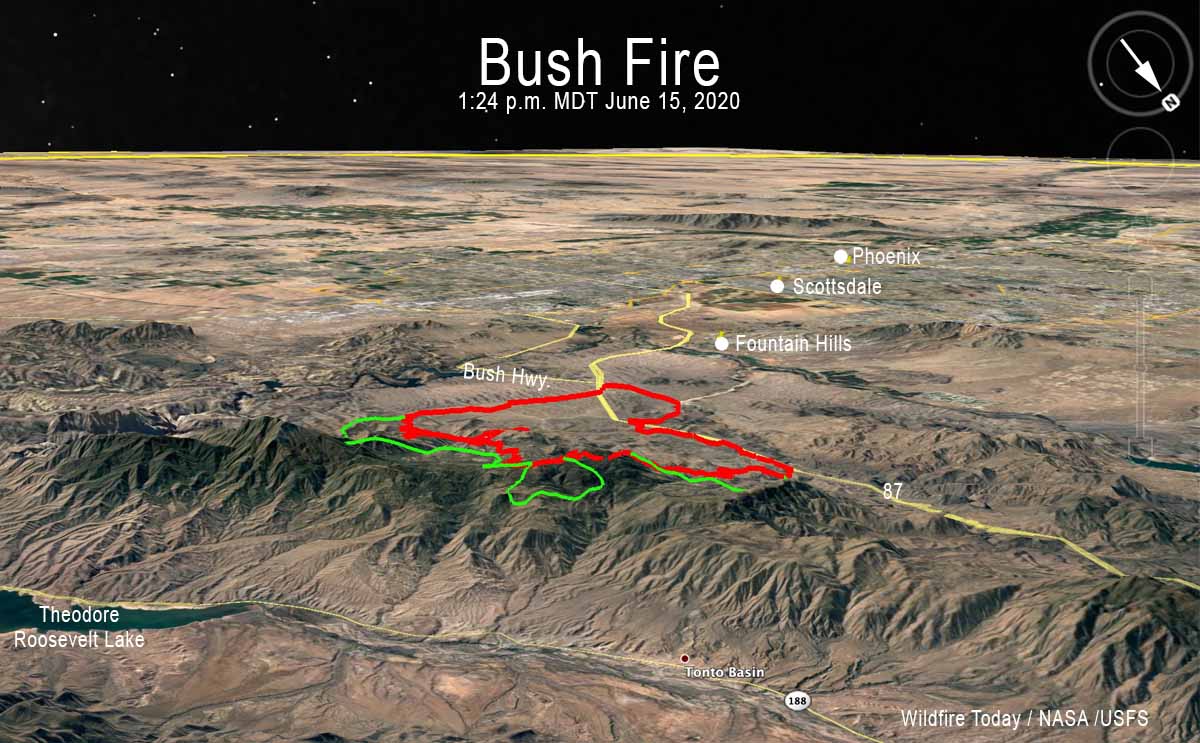
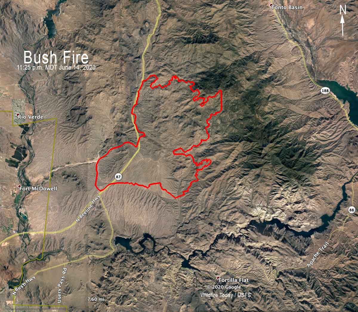
3-D Map of the Bush Fire northeast of Phoenix looking southwest. The red line was the perimeter at 11:25 p.m. MDT June 14, 2020. The green line was the additional growth through 1:24 pm MDT June 15, 2020.
Map of the Bush Fire northeast of Phoenix
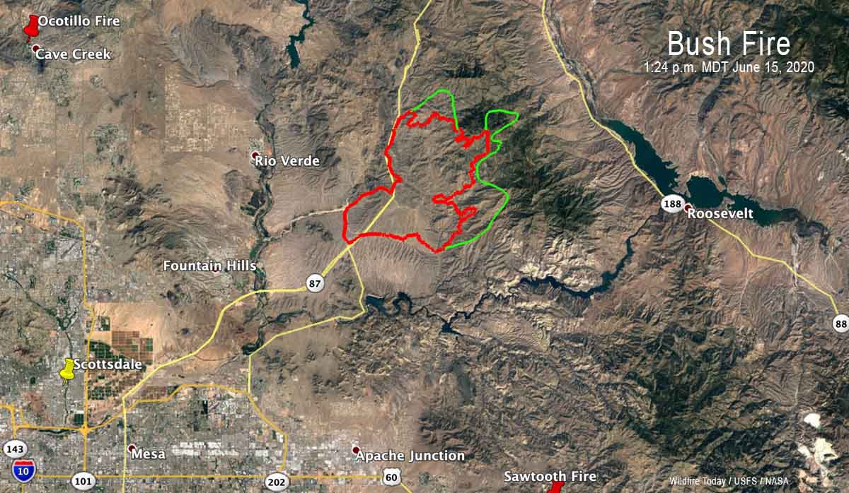
Map of the Bush Fire northeast of Phoenix. The red line was the perimeter at 11:25 p.m. MDT June 14, 2020. The green line was the additional growth through 1:24 pm MDT June 15, 2020.

Lost Creek Fire burns hundreds of acres west of Cody, WY

23 miles east of Yellowstone’s east entrance

3-D map of the Lost Creek Fire
3-D map of the Lost Creek Fire east of Yellowstone National Park, based on a mapping flight at 2:36 a.m. MDT June 14, 2020.

The Lost Creek Fire in northwest Wyoming had burned 591 acres when a mapping aircraft overflew the fire at 2:36 Sunday morning. The blaze is on the south side of Highway 14/16/20, 23 miles west of Cody and 23 miles east of Yellowstone National Park’s east entrance. It was reported at 12:45 p.m. on Saturday.

Sunday morning the resources assigned or working on the fire included two Type 1 hand crews, multiple engines, two heavy air tankers, three single engine air tankers, two Type 1 helicopters, and one Type 3 helicopter. The Bill Cody Ranch and Rimrock Dude Ranch remain under an evacuation order.

A public meeting will be held at 5:00 p.m. Sunday at the Sheep Mountain Day Use Area of Buffalo Bill State Park. Due to ongoing health concerns, fire managers are asking the public to limit attendance to those directly impacted, and to limit the number of people per household that attend.

Restricting the number of attendees makes sense, but is certainly a change from the pre-COVID policy. It could be helpful if it were also live-streamed and available on the internet.

So far there has been no report of the highway being closed or restricting access to the east entrance of Yellowstone National Park. Here is a link to Wyoming road information.

Traffic Lost Creek Fire

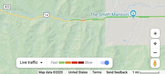
Google Maps showed slowing of traffic on the highway at 1:02 p.m. Sunday.

The map below shows the location of the fire relative to Yellowstone and Cody.

Vicinity map of the Lost Creek Fire
Vicinity map of the Lost Creek Fire west of Cody, Wyoming.

“Bush Fire” closes SR 87 northeast of Phoenix

Evacuations are in effect

(UPDATED at 6:30 p.m. MDT June 15, 2020)

3-D Map of the Bush Fire northeast of Phoenix
3-D Map of the Bush Fire northeast of Phoenix looking southwest. The red line was the perimeter at 11:25 p.m. MDT June 14, 2020. The green line was the additional growth through 1:24 pm MDT June 15, 2020.

Monday afternoon the Incident Management Team on the Bush Fire announced that it had burned 37,900 acres.

For all articles on Wildfire Today about the Bush Fire northeast of Phoenix including the most recent, click here.


(UPDATED at 3:13 p.m. MDT June 15, 2020)

Bush Fire Map Phoenix Arizona wildfire
Map showing the perimeter of the Bush Fire at 11:25 p.m. MDT June 14, 2020.

Here is a zoomed-in version of the map showing the location of the Bush Fire northeast of Phoenix at 11:25 p.m. MDT June 14, 2020. The data is from a fixed wing mapping aircraft.

For all articles on Wildfire Today about the Bush Fire northeast of Phoenix including the most recent, click here.


(UPDATED at 1:13 p.m. MDT June 15, 2020)

Bush Fire, northeast of Phoenix
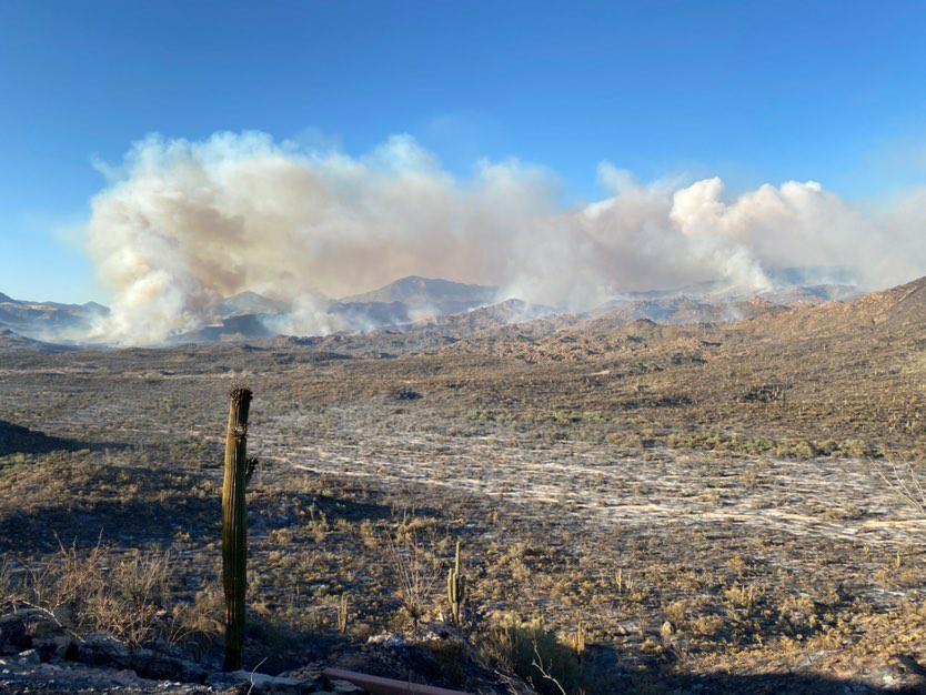
Bush Fire, northeast of Phoenix, June 14, 2020. Inciweb photo.

At 9:46 a.m. MST on Monday a notice from the Gila County Sheriff’s Office said, “The Tonto Basin and Punkin Center area are being evacuated. If you need to travel into the evacuated areas to remove livestock and or property you will be allowed to do so.”

A notice from the Sheriff’s office also reported, “Highway 87 from the Bush Highway M/P 199 north bound and south bound to BIA 101 entrance to the Matazal Casino in Payson is closed due to the fire on Highway 87. Only local traffic will be permitted. Residents in the local areas i.e. Rye, Gisela, Deer Creek, Ox Bow will be permitted to travel into Payson and return home. The Junction of Highway 87 and Highway 188 is closed. Highway 188 to the Roosevelt Dam is closed.”

The weather is not helping the firefighters. The forecast for the fire area on Monday is for temperatures of 81 to 91, relative humidity 12 to 17 percent, and no chance of rain. The winds will become southwesterly at 6 to 15 mph by the late morning/early afternoon. Gusts of 20-25 mph will occur over most of the mountain range, but ridgetops could see gusts nearing 30 mph. Monday night the winds will be southwest at 5 to 10 mph.


(UPDATED at 7:10 a.m. MDT June 15, 2020)

Bush Fire map
Bush Fire Permeter at 11:25 p.m. MDT June 14, 2020.
bush fire phoenix
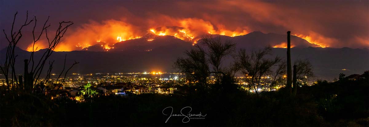
Bush Fire northeast of Phoenix, Arizona. Photo by James Stamsek, June 14, 2020.

The Bush Fire was mapped at 36,257 acres Sunday night. We will post more about this fire later.


(Originally published at 9:36 a.m. MDT June 14, 2020)

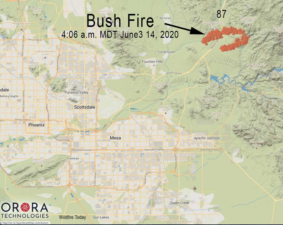
Bush Fire Highway 87 Phoenix
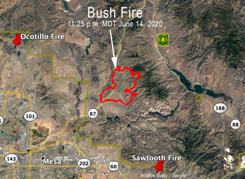
Map showing the approximate location of the “Bush Fire” north of Mesa, Arizona. If light fuels burned and then cooled before being detected by the next satellite overflight, the fire could be larger than shown.

Both lanes of State Route 87 are closed northeast of Phoenix, Arizona due to a vegetation fire that was unfortunately named “Bush Fire”.

The northbound lanes are closed at Bush Highway at milepost 199, according to the Arizona Department of Transportation. The southbound highway is currently closed at State Route 188.

There is no estimated time to reopen. Drivers are encouraged to use an alternate route, such as US 60 and SR 188 through Globe, or delay travel if possible.

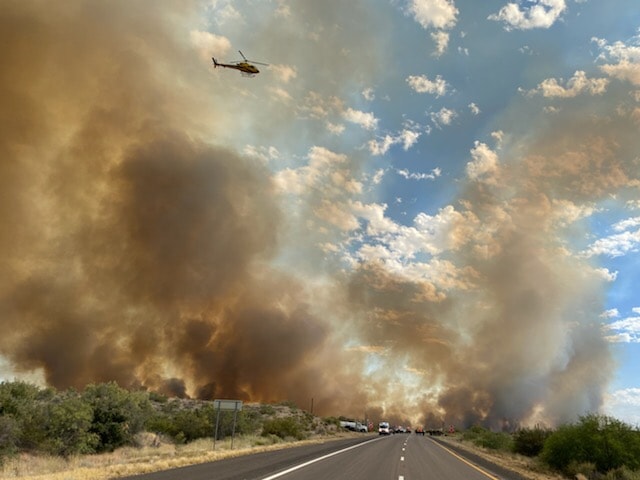
Bush Fire Highway 87 Phoenix
Bush Fire, June 13, 2020. Tonto National Forest photo.
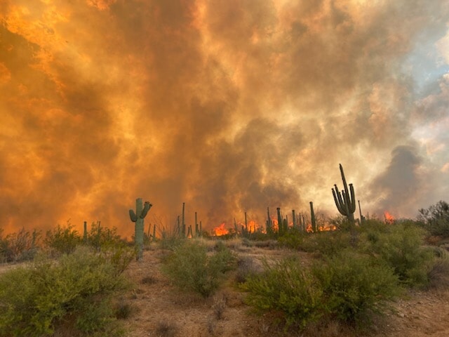
Bush Fire Highway 87 Phoenix
Bush Fire, June 13, 2020. Tonto National Forest photo.


Smoke from wildfires in Arizona affects Utah, New Mexico, Wyoming and other states

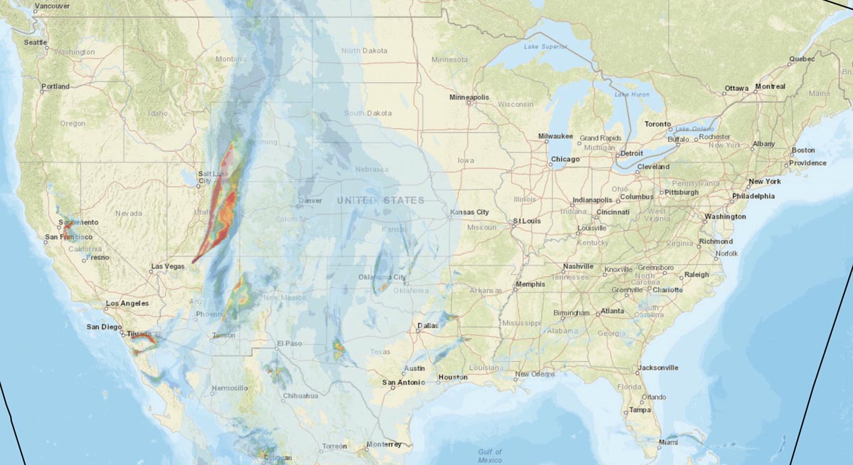
Forecast for wildfire smoke
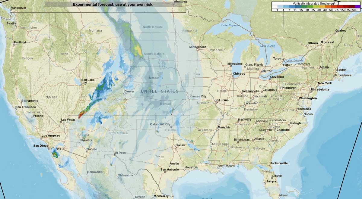
Forecast for wildfire smoke at 9 p.m. MDT June 13, 2020. Vertically integrated and near surface smoke. NOAA.

Smoke from wildfires near Tucson and north of the Grand Canyon is being pushed by strong winds into states to the north and northeast. Most heavily affected are residents in Utah, Colorado, Wyoming, and New Mexico.

The Mangum Fire near Jacob Lake, Arizona ran for 8 miles Friday and is very active again today.

Mangum Fire Arizona
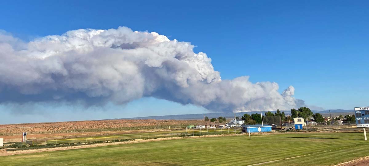
Smoke from the Mangum Fire in northern Arizona as seen from Fredonia High School 18 miles northwest of the fire, June 12, 2020. InciWeb photo.