Wildfire potential, March through June

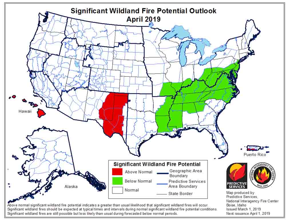
If NIFC’s analysis is correct, wildfire activity should begin to increase in Eastern New Mexico and Western Texas in April.

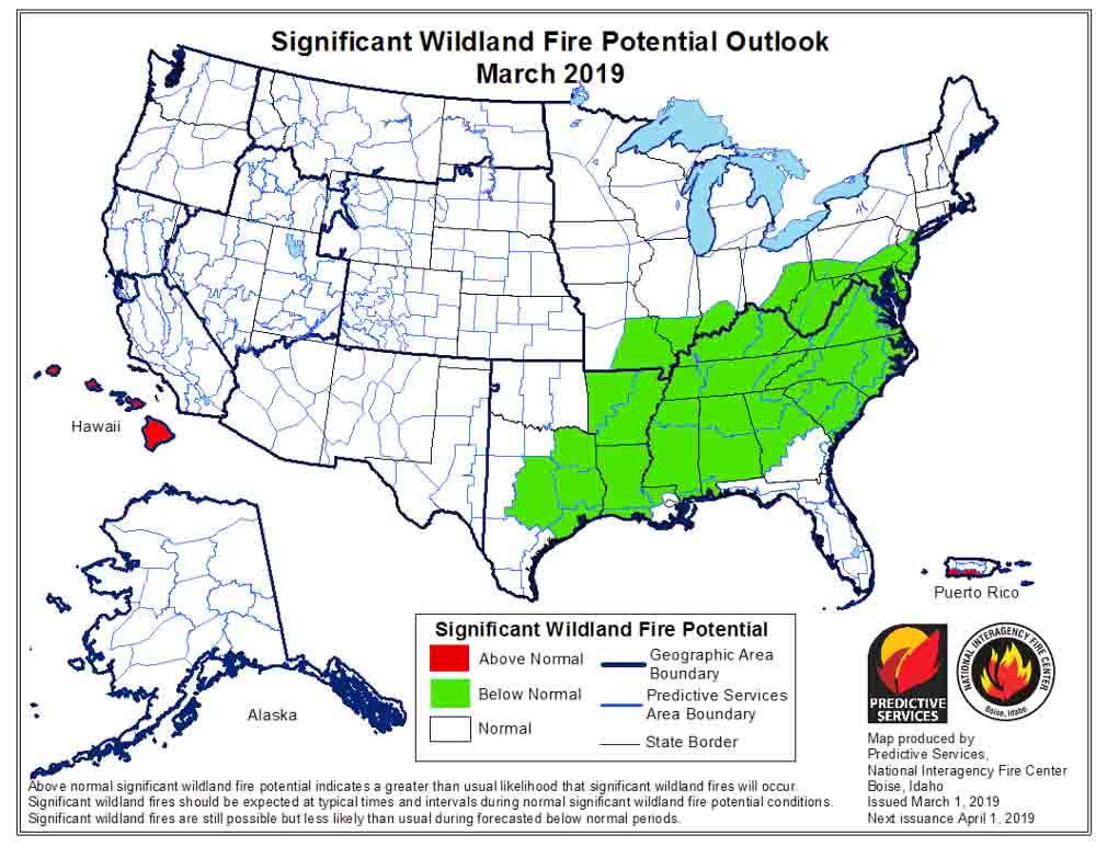
wildfire potential fire danger outlook forecastOn March 1 the Predictive Services section at the National Interagency Fire Center issued their Wildland Fire Potential Outlook for March through June. The data represents the cumulative forecasts of the ten Geographic Area Predictive Services Units and the National Predictive Services Unit.

If NIFC’s analysis is correct, in April wildfire activity should begin to increase in Eastern New Mexico and Western Texas. In May it will transition to the greater Grand Canyon area, with much of California added in June.

Below:

  • An excerpt from the NIFC narrative report for the next several months;
  • More of NIFC’s monthly graphical outlooks;
  • NOAA’s three-month temperature and precipitation forecasts; and,
  • Drought Monitor.

The majority of the nation remained out of fire season in February. The minimal fire activity observed continued to be well below average nation-wide. What was observed was minimal and limited mainly to the western fringes of the Southern Area. While a weak El Niño persisted, resulting weather conditions were atypical to what is often observed during such events. Precipitation was generally near to above average in most locations except for two regions. The central and southern Great Plains were especially dry, and the Deep South had pockets of dry conditions as well. Portions of West Texas and eastern New Mexico received less than 5% of average precipitation. Overall, the Deep South fared better but portions of the Carolinas and the lower Mississippi River Valley recorded below average precipitation.

Temperatures were generally within about 3 degrees of average across the country. A slight cold bias existed in the West and across the northern tier. A slight warm bias existed across the South and Texas. Extreme departures from average were observed across the northern Great Plains where temperatures were as much as 25 degrees below average.

The frequency and strength of Pacific weather systems moving on shore and across the West allowed for above average precipitation to reduce the severity and scope of the ongoing drought across California and portions of Oregon and the Great Basin. Incredible amounts of snowfall intermittently shut down travel across the High Sierra in California. Soil moisture levels improved across most areas except western Oregon where the persistent dry conditions continued.

March is a transition month. Pregreenup grassfire activity is not uncommon along and east of the Rocky Mountain Front. At least average activity is expected until green up takes hold. Concerns decrease west of the Continental Divide where sustained periods of wet and cold conditions have persisted the past few months. As greenup takes hold in April, most areas experiencing preseason activity should begin to see a decrease except for the Southwest where the drying of fuels begins to show a gradual westward migration of fire activity.

Fire activity in May and June should increase in coverage and intensity across the Southwest and California. Some slight expansion of activity into the southern Great Basin is also expected. The above average precipitation received during the late winter and early spring months could translate to another above average grass crop that could prove to be problematic in June.

wildfire potential fire danger outlook forecast

Continue reading “Wildfire potential, March through June”

TBT, 10 years ago: Researcher says humans “mastered fire” 790,000 years ago

From an article we posted on February 28, 2009:


A researcher who excavated 12 layers of soil deposits from the shore of an ancient lake near the river Jordan found evidence that fire had been used by humans in every layer. The soil layers were laid down by waters from the lake in between occupancies by the different societies of humans that inhabited the site 790,000 years ago. Nira Alperson-Afil from the Hebrew University of Jerusalem, Israel, concluded that humans would have had to have mastered the art of creating fire for it to have shown up in all 12 layers.

Previous research had shown that humans from this period could manipulate and use fire, but it was not clear whether they had the ability to create the fire themselves.

The researcher did not say if 790,000 years ago the users of fire had to obtain burning permits, get NEPA compliance, or write burn plans before they started their fires.

CLIF to donate 100% of profits from one of their bars to 2nd responder fund

The first project will help build a new Butte Humane Society facility that will shelter and care for animals impacted by the Camp Fire in California.

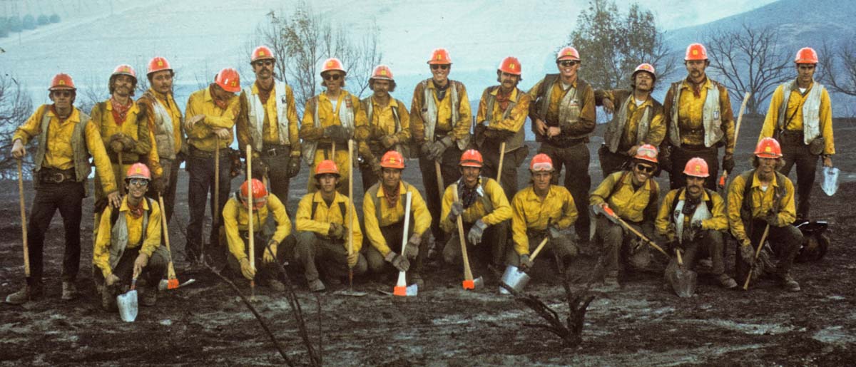
I first learned about Clif Bars after discovering that a former coworker, Bruce Lymburn, was the company’s General Counsel. Bruce and I were members of the El Cariso Hot Shots back in the day.

Clif seems like an interesting place to work. Clif Bars are mostly made from organic ingredients, employees can bring their dogs to work, the company gives back to the community through the CLIF Bar Family Foundation, employees are encouraged to volunteer in the community on company time, and they can take two and a half hours of paid exercise each week with free personal training.

The San Francisco Bay Area company made the news the other day with the creation of the CLIF Second Responder Fund.

Most everyone knows what first responders are. They are the first to arrive at emergency scenes — the ones you see in the news — law enforcement, firefighters, and emergency medical personnel. Second responders are the ones that work during the recovery phase, which can last for days, weeks, or months. Examples include power companies, communication companies, hazardous waste cleanup, and services providing food, road clearing, security, first aid, crowd control, sanitation, temporary housing, and social services. The establishment of the CLIF Second Responder Fund will support some of the unmet needs of these second responder efforts.

Clif BarOne hundred percent of all net profits from the sale of Sierra Trail Mix CLIF BAR® Energy Bars will go toward establishing the fund for the long term. Clif Bar & Company has a long history of post-disaster work in communities, often serving as a “second responder” by volunteering, providing financial support and food donations.

The first project of the fund will provide $1.5 million to the community affected by the Camp Fire in Butte County, the deadliest and most destructive wildfire in California history. This fund will help the community break ground on a new state-of-the-art Butte Humane Society facility that will shelter and care for animals impacted by the Camp Fire disaster, as well as serve as an emergency center for Northern California in the event of future disasters.

“The devastation created by these fires is unfathomable,” said Gary Erickson co-owner and co-CEO of Clif Bar & Company. “After the flames are extinguished and the camera crews leave, these communities are still desperate for help. This fund will help this community in our own backyard and other communities around the country for years to come.”

The fund was inspired by the work of Sierra Nevada Brewing Co. owners Ken Grossman and Katie Gonser, whose community in Chico, California was among those devastated by the Camp Fire. Like Clif Bar, Sierra Nevada is also a family-owned business and the two families have been friends for years. When the fire was in its early stages, Erickson and his wife, Clif Bar & Company co-owner and co-CEO Kit Crawford, reached out to Grossman and Gonser to see how Clif Bar could help.

“When Gary and Kit called, we knew we needed help for our community’s animals. As we listened to the stories and responded to the needs of the community, we knew that help would still be needed long after the initial push of relief had waned,” said Gonser. “The devastation was enormous, with many local families distraught over the lack of care of displaced animals. This shows what two businesses can achieve by working together.” Grossman and Gonser have already donated the land for the new facility.

“Clif is a company full of animal lovers, with many employees bringing their dogs to work with them every day. Not only are animals amazing companions, they’re family,” added Kit Crawford, Co-Owner and Co-CEO of Clif Bar & Company. “We are proud to champion this initial effort and know that this fund will be ongoing to address other needs following national disasters around the country.”

It’s estimated that more than 20,000 animals were impacted by the Camp Fire. The Butte County Humane Society responded immediately, reuniting residents with their pets, providing thousands of pounds of pet food to people who were displaced, and caring for hundreds of injured pets. Through the experience, the staff learned each day and knew a new facility with an expanded mission was needed.

The new Butte Humane Society facility can serve as a centralized information headquarters for animal welfare groups in order to coordinate collective long-term recovery efforts and in preparation for disaster support throughout Northern California. Additionally, in collaboration with other first and second responder animal organizations, the new campus can be used as a crisis evacuation site during local and regional disasters. BHS hopes this will serve as a model for emergency preparedness and response around the country.

The new Sierra Trail Mix packaging will be rolled out nationally this summer in stores and online.

1972 El Cariso Hotshot crew
Part of the 1972 El Cariso Hotshot crew. Bruce Lymburn is at the end of the back row, on the left. Missing: Ron Campbell (superintendent) and Bill Gabbert (took the photo).

In 2007 and again in 2008 Senators Hillary Clinton and Peter King introduced the Skilled Trades Second Responders Act of 2008, which would have established a national program for the training, certification, registration, tracking, and integration of skilled construction workers to assist first responders in responding to disasters, including natural and manmade disasters and terrorist attacks. Both bills died in committee.

Bill to provide real-time location of fires and firefighters sent to the President

The legislation passed both the House and the Senate with overwhelming bipartisan support

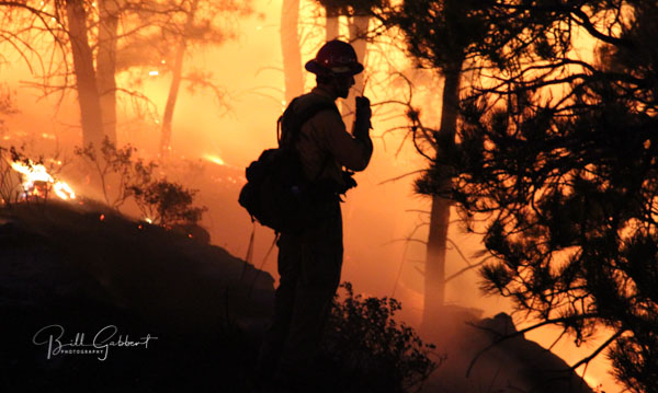
firefighter radio White Draw Fire
A firefighter on the White Draw Fire uses a radio to coordinate with other firefighters. July 29, 2012. Photo by Bill Gabbert.

A bill that directs the federal land management agencies to begin implementing a system that would enhance the situational awareness of wildland firefighters has passed both the House and the Senate and is awaiting the signature of the President.

On February 12 the Senate passed the John D. Dingell, Jr. Natural Resources Management Act with a vote of 92 to 8, and yesterday the House passed it 363 to 62. (Update: it became law March 12, 2019 when it was signed by the President.)

The bill also includes numerous other actions related to public lands including creating more than 1.3 million acres of wilderness out West, adding three national park units, and expanding eight others.

If the bill passes and is actually implemented by the federal land management agencies it would generate progress toward what we have called the Holy Grail of Wildland Firefighter Safety, knowing the real time location of a fire and the resources assigned. Too many firefighters have been killed when the exact location of one or both of these critical aspects of situational awareness were unknown. Recent examples with a total of 24 line of duty deaths were on the Yarnell Hill and Esperanza Fires.

The technology to monitor in real time a fire and firefighting resources has existed for years. Various systems are being used already by a few state and local agencies. The military does it for their war fighters, monitoring the enemy and their own forces. If implemented on fires, it will save lives.

Firefighters lives are as important as soldiers.

“I am proud that our Public Lands package passed the House yesterday and that we were able to include in it Senator Cantwell and Senator Gardner’s seminal bill to better equip our firefighters”, said Senator Joe Manchin, Ranking Member of the Senate Energy and Natural Resources Committee. “It is plain to see that wildfires are getting worse not better, and I want to ensure these brave men and women have access to the tools available that will keep them safe, as they work to keep us safe.”

The key points, below, in the legislation have requirements for the Secretaries of Interior and Agriculture. The completion dates will be established from the time the legislation is signed. (UPDATE: the bill was signed by the President March 12, 2019)

    • Establish a research, development, and testing program, or expand an applicable existing program, to assess unmanned aircraft system technologies, including optionally piloted aircraft, across the full range of wildland fire management operations. (within 180 days)
    • Develop consistent protocols and plans for the use on wildland fires of unmanned aircraft system technologies, including for the development of real-time maps of the location of wildland fires. (within 180 days)
    • Develop and operate a tracking system to remotely locate the positions of fire resources, including, at a minimum, any fire resources assigned to Federal Type 1 wildland fire incident management teams. (within 2 years)  According to a press release by Senator Maria Cantwell, by the 2021 fire season, all firefighting crews – regardless of whether they are federal, state, or local – working on large wildfires will be equipped with GPS locators.
    • Establish a system to track and monitor decisions made by state and federal wildland firefighting agencies to flag unusual costs, and those that endanger firefighters or deviate from an applicable fire management plan. (no time requirement)
    • Assign air quality resource advisors to Type 1 incidents managing a fire on federal land. (no time requirement)
    • Establish a system to collect data on firefighter injuries that were treated by a doctor, and all deaths during the Work Capacity Test, vehicle crashes, and aircraft accidents. (no time requirement)
    • The two Secretaries will work with NASA to establish a “Rapid Response Erosion Database” and maps that would make it possible to evaluate changes in land cover and soil properties caused by wildland fires. (no time requirement)
    • The two Secretaries, NASA, the Secretary of Energy, and the National Laboratories shall establish and maintain a system to predict the locations of future wildfires for fire-prone areas of the United States. (no time requirement)

The bill does not appropriate any additional funding to implement the real-time tracking provision. A study by the Congressional Budget Office concluded that the estimated $8 million cost is “insignificant” in the overall billions of dollars spent on wildland fire. Discussions behind the scenes in Washington are centered around small tracking devices being included in kits available from the wildland fire warehouse system which can be ordered by incident management teams the same way they order radio kits. The devices could then be distributed to personnel and other resources on fires. The newer Bendix-King radios used by firefighters already have GPS receivers which could be used to provide location data in a tracking system.

Now the question becomes, will the federal land management agencies actually implement the program to track the real-time location of fires and firefighters, or will they slow-walk it into oblivion like the Congressional orders to purchase a new air tanker, convert seven HC-130H Coast Guard aircraft into air tankers, and the repeated requests from the GAO and Inspector General to provide data about the effectiveness of firefighting aircraft?


(UPDATE February 28, 2019)

Feather River Hospital evacuated 280 patients and staff as Camp Fire approached

Nine buildings on the campus burned as well as the lower level of the hospital

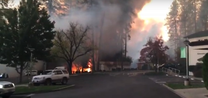
Feather River Hospital Camp fIre burned
Screenshot from a video shot by Feather River Hospital employees as the fire approached.

The details about the evacuation of Feather River Hospital as the Camp Fire tore through Paradise, California on November 8, 2018 were not covered throughly by the national news. The top stories were the 85 people that were killed and the 14,000 homes and businesses destroyed.

The NFPA Journal has an article that covers some of the facts about the evacuation.

The fire was reported at 6:29 a.m. near a high voltage power line northeast of Paradise. Ryan Ashlock, the “administrator on call” that morning, saw the smoke at 7 a.m. when he arrived at the hospital on the east side of Paradise (map). At 7:15 employees could smell smoke inside the building. As the fire pushed by strong winds got closer, at 7:45 Mr. Ashlock called a code triage external, which means there’s something going on in the outside world that they need to be aware of, and that units need to prepare themselves for anything that might be coming.

At 8 a.m. the hospital was within a mandatory evacuation area. At first the staff thought they would be safer inside the building and could shelter in place, in part because the structure had firewalls that can retard the spread of a fire through the building. But a few minutes later the blaze had approached both ends of the hospital’s campus. Mr. Ashlock ordered a full evacuation at 8:07. The staff escorted ambulatory patients, pushed some in wheel chairs, and wheeled others in their beds to the emergency room entrance or the helipad.

The staff made calls in attempts to get ambulances and helicopters to transport patients, but due to gridlocked traffic and the fire, only two ambulances from Chico made it to Paradise near the end of the evacuation. One arrived at the hospital, while the other caught fire and burned. Helicopters could not land at the helipad due to the smoke.

By 8:50 they had evacuated 80 patients and 200 employees. One critically ill intensive-care patient died that day.

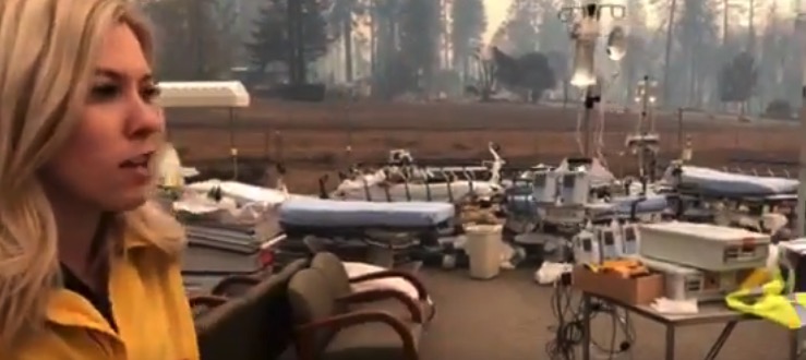
Feather River Hospital Camp fIre burned
Screenshot from KRCR TV showing hospital equipment left at the helipad after the evacuation.

Below are excerpts from the NFPA article, in the words of Mr. Ashlock:

8:20 a.m.

Our evacuation plan called for ambulances to come from the town of Paradise. But it’s a small community, so there aren’t many ambulances readily available. Most would come from Butte County. But we weren’t seeing any of those local ambulances and we didn’t know where they were. We were also concerned that ambulances from Chico might not get up here because of the traffic resulting from the entire town of Paradise being evacuated.

Someone over in the emergency department figured out that ambulances weren’t coming. There were Paradise police and Butte County Sheriff’s Office people on site, and I went out to talk to them. As nicely as I could, I asked them, “Where are the firefighters to protect the hospital, and where are the ambulances to help us evacuate?” They said, “We’ve called, and no one’s responding.”

The decision was made to start putting patients into the emergency vehicles that happened to be there, and the rest would have to be put into the personal vehicles of hospital employees—we weren’t going to get off that campus by sitting and waiting for ambulances or firefighters to show up. Clinicians got patients into wheelchairs, patients who could walk were escorted down to the emergency department, patients who were in the ICU or who were unable to walk or get into wheelchairs were rolled out in their beds.

8:50 a.m.

All patients were out of the hospital. The fire stayed about 400 yards away because of the defensible area around the hospital. But the wind started to kick up and embers were blowing over us, and spot fires were starting all around us. Our central plant, where we have our boilers and chillers and generators, was starting to catch fire about the time we got everyone out of the main hospital building. Some of our buildings at the edge of campus were burning, along with our IT building.

Mr. Ashlock said the lower level of the hospital burned pretty extensively, and of the 15 administrative buildings on the campus, nine burned, as well as one clinic.

The video below was shot by Feather River Hospital employees as the fire approached.

Anonymous Twitter account blasts employee housing at NPS site

National Park Service substandard employee housing
Photo posted by @NastyWomenofNPS

A Twitter account that has been verified by Snopes as having a legitimate connection to the National Park Service has described the substandard living conditions of employee housing at one NPS site.

Firefighters and other land management agency employees that work in remote areas sometimes find that government housing is their only option. The agencies are required to charge them rent at the going rate in the area — they don’t get a bargain just because it is far from civilization.

The details and the seven photos posted by @NastyWomenofNPS are specific about one NPS location and do not necessarily represent conditions at other parks.

The person described what it is like living in a $500 a month 50-year old mobile home that is 80 miles from the closest real grocery store —  no key to lock the door, no heat or air conditioning in the bedroom, walls falling apart, mice enter through holes in the floor, no hot water in bathroom, ice forms in electrical outlets, insulation falls from ceiling, and the electrician said get renters’ insurance because “there will be a fire”.

Click on the tweet below to see the photos and the multiple-message thread.

Not all government housing is as dilapidated as described here. In some cases the local unit is doing the best they can with a very limited infrastructure budget and staff.

Are you aware of any other particularly good or bad examples of government housing?