West Fire burns numerous structures at Alpine, California

Above: The West Fire at Alpine, California. Screenshot from KUSI video.

(UPDATED at 4:37 p.m. PDT July 6, 2018)

CAL FIRE said the spread of the West Fire has been virtually stopped, but there is still quite a bit of active fire between structures that is threatening buildings. Firefighters will be working throughout the night to mitigate the threat.


(Originally published at 3:33 p.m. PDT July 6, 2018)

A destructive wildfire broke out during a heat wave in Southern California Friday. As the temperature in eastern San Diego County exceeded 100 degrees the West Fire started on the east side of Alpine and quickly spread through residential areas south of Interstate 8.

At 3:30 p.m. the fire had burned approximately 350 acres.

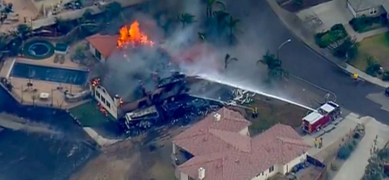
In viewing video shot by KUSI News, it appeared that many structures were likely victim to the flames.

There may have been a close call involving an inmate crew. The tweet below has an unfortunate choice of words, but the crew appears to be moving as rapidly as possible away from advancing flames.


The screenshot below from the KUSI video (at -41:20) was probably just after the crew “escaped” the flames only to have to confront traffic on the busy lanes of Interstate 8 which appeared to be fully open. They can be seen running at first.

inmate crew west fire alpine
An inmate crew appeared to have a close call on the West Fire on Interstate 8 at Alpine, CA July 6, 2018.

The video, if you can deal with the constantly panning camera, shows many examples of structures burning. I skimmed through and while I saw a couple of places with retardant on the ground, I only saw one air tanker, a 1,200-gallon S-2T, making a drop. I didn’t see any helicopters, but there could have been many aircraft that I missed or didn’t appear in front of the camera. Eight air tankers were reloading with retardant at Medford, Oregon Thursday while fighting the Klamathon Fire just south of the California/Oregon border.
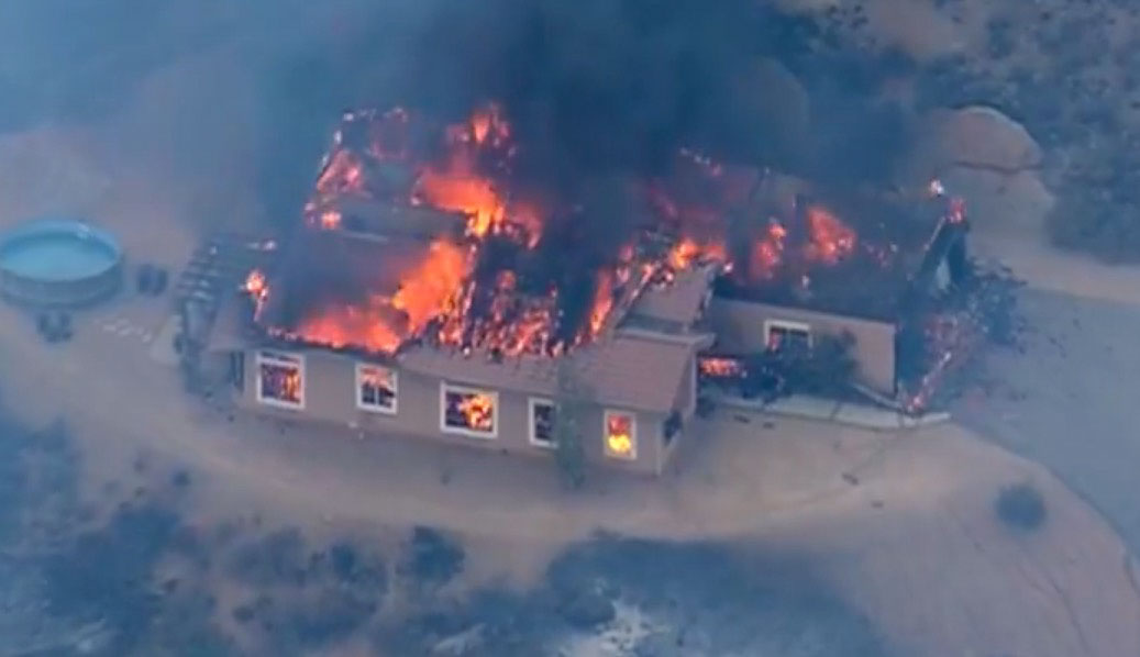
West fire alpine CA
West Fire. Screenshot from KUSI video.
West fire alpine CA
West Fire. Screenshot from KUSI video.

From the photos below it appears that the fire burned up against the back yard of the USFS Descanso Ranger District office at 3348 Alpine Blvd. and was also very active across the street.

Tornado observed near Weston Pass fire in Colorado

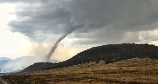
Tornado Weston Pass Fire
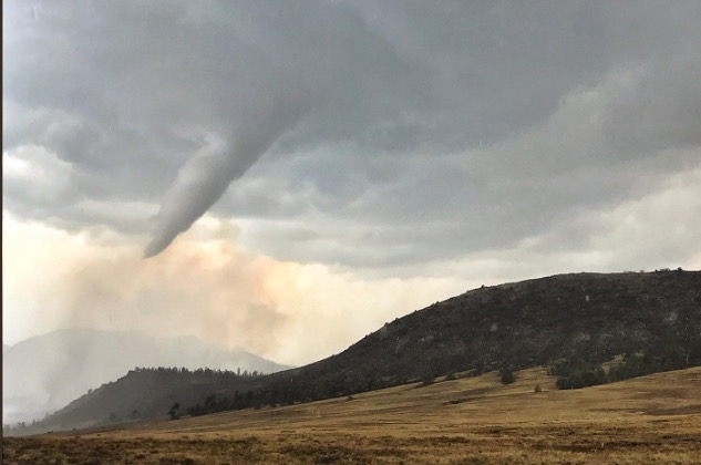
Tornado near the Weston Pass Fire. Photo by Wellington Fire Department, @WellingtonFire1.

Wildland firefighters have enough to worry about,  but Thursday a tornado briefly touched down just south of the Weston Pass Fire, then while receding back into the cloud it moved directly over the fire.

Tornadoes are very rare in this part of the country. According to the National Weather Service office in Boulder, it was the 6th confirmed tornado in Park County since records began in 1950.

Chief Meteorologist/Climatologist for 11 News in Colorado Springs, said “No, this isn’t a firewhirl, it is a legit tornado produced by a thunderstorm that moved across the Weston Pass Fire.”

The Weston Pass Fire has burned about 13,000 acres 9 miles southwest of Fairplay, Colorado.

Tornado Weston Pass Fire
Tornado near the Weston Pass Fire. Photo by Wellington Fire Department, @WellingtonFire1.

Thanks and a tip of the hat go out to Jason.
Typos or errors, report them HERE.

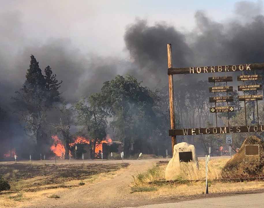
Klamathon Fire burns into Hornbrook, California, closes I-5

(Above: CHP photo)

(UPDATED at 12:37 p.m. PDT July 6, 2018)

From KOBI5:

A civilian has died due to the Klamathon Fire, CAL FIRE reported Friday morning. The identification of the person will be released after further investigation and notification of next-of-kin. No further information was released.


(UPDATED at 7 a.m. PDT July 6, 2018)

CAL FIRE reported at 6 a.m. MDT Friday that the Klamathon Fire along Interstate 5 just south of the Oregon border is now 8,000 acres with “multiple structures threatened and damaged or destroyed”. Evacuation orders are in effect.

The California Highway Patrol is now escorting traffic on Interstate 5 through the burned area.


(Originally published at 3:35 a.m. PDT July 6, 2018)

The Klamathon Fire that started Thursday afternoon under windy conditions in northern California spread very quickly into the small community of Hornbrook. Burning on both sides of Interstate 5 it kept going north at least another seven miles to another small town, Hilt, which is about a mile south of the Oregon border.

CAL FIRE said approximately 5,000 acres and multiple structures have burned.

Interstate 5, the major thoroughfare connecting California and Oregon, was closed Thursday night between Yreka, CA and Ashland, OR.

Klamathon Fire
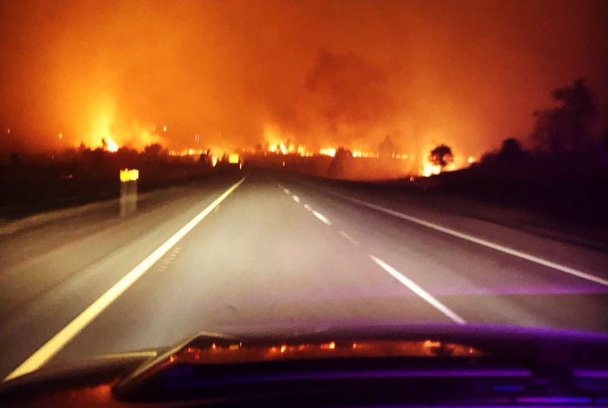
Klamathon Fire, Friday night. CHP photo.
Klamathon Fire
Klamathon Fire, Friday night. CHP photo.

While the fire was growing quickly Thursday afternoon a 20 to 26 mph south wind was pushing it along the Interstate. By midnight the wind slowed to just a few miles per hour and that trend is predicted to continue Friday, but the relative humidity will still be low, around 15 percent. This should slow the spread somewhat, but now firefighters have thousands of acres of fire to contend with.

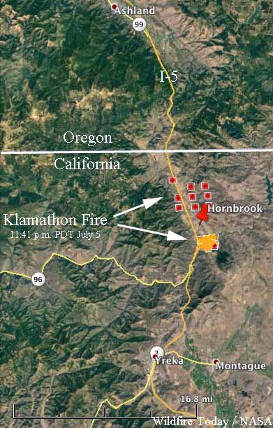
map Klamathon fire
Map showing the approximate location of the Klamathon Fire at 11:41 p.m. PDT July 5, 2018. The red dots are the most current. We hope to replace this with a better map when it becomes available.

There are no details yet about the extent of damage in the communities, but the early indications are that it could be severe.

Evacuations ordered for Lake Christine Fire at Basalt, Colorado

Tracer rounds used at a shooting range started the fire, officials said

Above: The Lake Christine Fire, Wednesday night. Photo: Katie Baum Hueth, Eagle County Sheriff’s Office.

(UPDATED at 8:19 a.m. MDT July 5, 2018)

Mandatory evacuations are in effect in several locations for the Lake Christine Fire that is burning between Basalt and El Jebel, Colorado 15 air miles southeast of Glenwood Springs.

The fire started July 3 from tracer ammunition being used by shooters near Basalt.

Fire officials estimated Thursday morning it has burned approximately 4,900 acres.

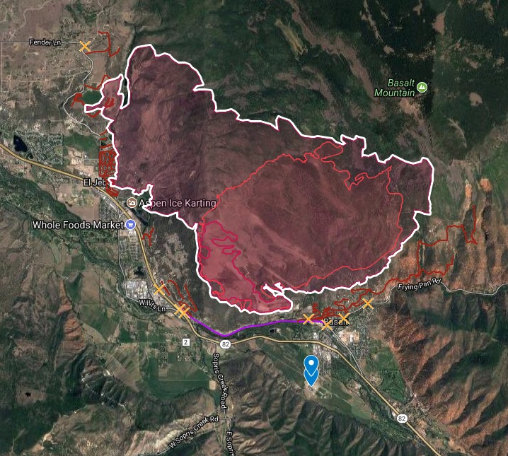
map lake christine fire
Map showing the location of the Lake Christine Fire between Basalt and El Jebel, Colorado, updated at 9:45 a.m MDT July 5, 2018.

Below is a time-lapse showing the growth of the fire on July 4.

Continue reading “Evacuations ordered for Lake Christine Fire at Basalt, Colorado”

Firefighters hope to prevent the County Fire from crossing Hwy. 128

The fire has blackened approximately 82,700 acres

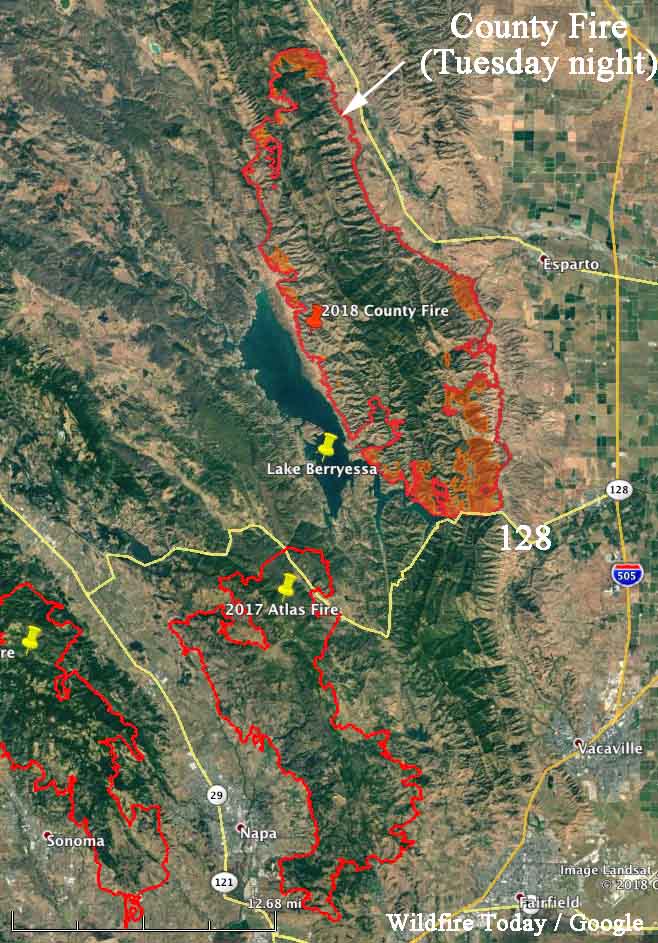
Above: The map shows the southern end of the County Fire where firefighters are working to keep it from crossing the narrow sections of Lake Berryessa and Highway 128. The red shaded areas represent intense heat observed during a Tuesday night mapping flight.

(Originally published at 8:19 a.m. PDT July 4, 2018)

During the first two days the County Fire 26 miles west of Sacramento burned about 1,000 acres an hour, but that spread has slowed recently as firefighters have has success, but difficult terrain in some areas has presented a challenge. The fire has blackened approximately 82,700 acres.

One of their main priorities is to keep the fire from moving south across Highway 128. The map above shows they have made progress toward that goal. If it spreads across the highway it would threaten many homes in the Allendale and Vacaville area. If it grows around the southern tip of Lake Berryessa it could burn into the footprint of last October’s Atlas Fire, northeast of Napa, where the resistance to suppression would decrease dramatically.

county fire map
Map showing the perimeter of the County Fire, Tuesday night.

Spring Creek Fire becomes third largest in state history

It has burned approximately 94,093 acres, displacing the High Park Fire for the number three position.

Above: A DC-10 drops retardant on the Spring Creek Fire. Undated photo by Garfield County Sheriff’s Office.

(UPDATED February 21, 2019)

The Spring Creek Fire ultimately burned 108,045 acres and 141 homes, becoming the third largest in the recorded history of Colorado. A Danish man living in the United States on an expired visa was charged with 141 counts of first-degree arson for allegedly starting the fire — one charge for each of the homes destroyed.


(UPDATED at 12:37 p.m. MDT July 5, 2018)

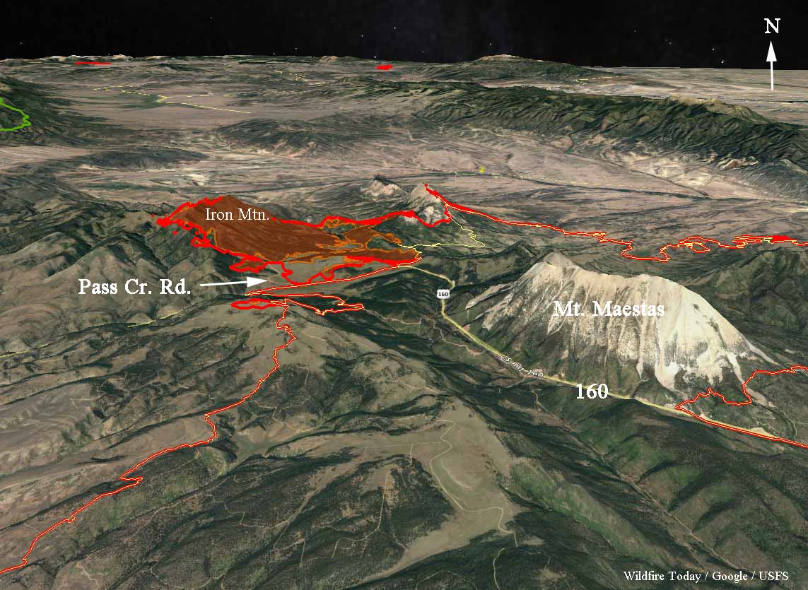
The Spring Creek Fire was very active Wednesday and Wednesday night spreading in a direction we have not seen very often since the fire started June 27. It spread rapidly on the northwest side running two to four miles west of Pass Creek Road working its way up Iron Mountain. It is unknown how far it may have continued after reaching the top. Clouds made it difficult to get good infrared data in that area.

The fire has burned approximately 103,000 acres as of early Thursday morning.

map spring creek fire
3-D map of the northwest section of the Spring Creek Fire, looking north, showing data from 12:46 a.m. MDT July 5, 2018.

Here is the outlook provided by the Incident Management Team:

Atmospheric moisture will continue to increase through the end of the week. However, given the current fuel conditions, the fire will continue to follow heavy continuous fuels to the north towards Gardner, the northeast towards Badito, to the east towards Three Bridges, to the south towards Cuchara and Indian Creek regardless of general wind direction. Potential for scattered thunderstorm activity which can cause gusty outflow winds in any direction.


(Originally published at 8:11 a.m. MDT July 4, 2018)

The Spring Creek Fire in southern Colorado between La Veta and Fort Garland added another 15,000 acres Tuesday to become the third largest in the recorded history of the state after Tuesday night’s mapping estimated that it has burned approximately 94,093 acres. A partial cloud cover made 100% precision impossible.

The five largest:

  1. Hayman Fire in 2002, 137,760 acres, NW of Colorado Springs
  2. West Fork in 2013, 110,405 acres, Wolf Creek Pass
  3. Spring Creek in 2018, 94,093 acres (preliminary mapping, still spreading) La Veta
  4. High Park Fire in 2012, 87,284 acres, west of Ft. Collins
  5. Missionary Ridge Fire in 2002, 71,739 acres, Durango

CLICK HERE to see all of the articles on Wildfire Today about the Spring Creek Fire.

Continue reading “Spring Creek Fire becomes third largest in state history”