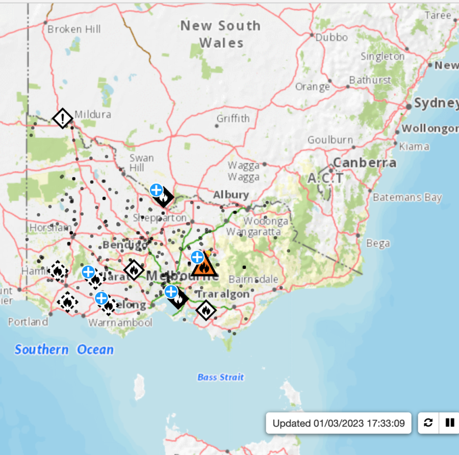
Bushfires are burning out of control northeast of Melbourne, the coastal capital of the Australian state of Victoria, and 9News reported that some residents have been told to leave immediately. Meanwhile, people in Maintongoon also have been issued a “leave immediately” warning. Updates will be posted at the VicEmergency website.
Map of Victoria bushfires
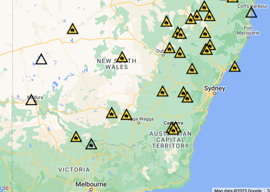
The Rural Fire Service (RFS) in New South Wales says some of the active bushfires are too dangerous to control, and that they may have been deliberately lit. The RFS has an interactive map online.
RFS map of New South Wales incidents
A firefighting aircraft has been called up to fight two large and out-of-control bushfires believed to have been deliberately lit near Moonie in Queensland’s Western Downs, according to ABC.net.au news.
On Tuesday night the RFS was called to two fires in the Waar Waar State Forest and Cattle Creek, and South West Region RFS Superintendent Wayne Waltisbuhl said that fire crews notified police.
“Some of the crew who arrived on scene last night observed some people in the area in a car and they took off very quickly,” he said. “That was suspicious at the time the fires were lit, so that information has been passed to police to follow up.”
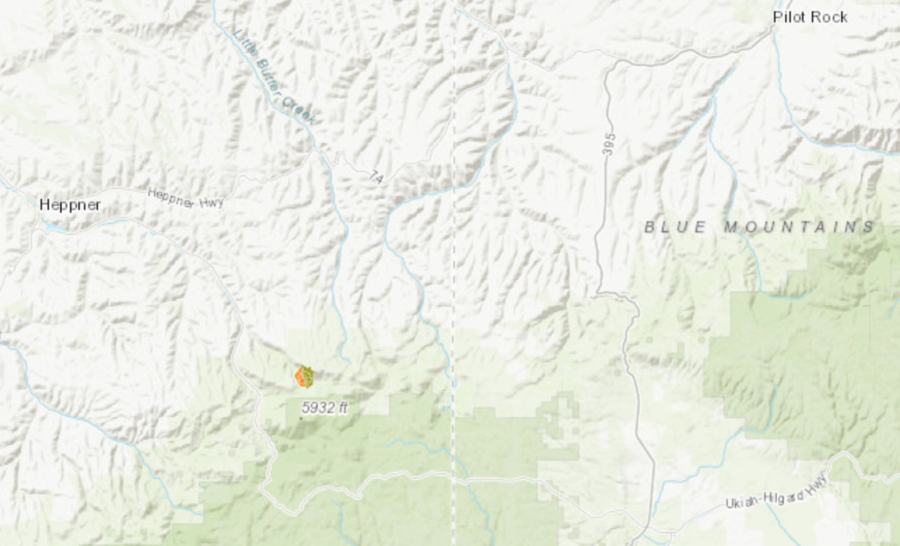
A bolt of lightning struck a tree just outside Bruce Wilcox’s home in Morrow County, Oregon last year, sending shards of wood flying 40 yards away. “It didn’t start a fire,” he said. “It just hit that tree and went to ground. But we were lucky.” Lightning-ignited fires are common in north-central Oregon, and Wilcox lives about 16 miles south of Heppner — home to the nearest fire department. Wilcox is helping his community, known locally as Blake Ranch, become the county’s first to join Firewise USA. He told Oregon Public Broadcasting that the Firewise program could be the key to protecting nearby homes from the next big wildfire.
Firewise is sponsored by the National Fire Protection Association (NFPA), and the Oregon Department of Forestry (ODF) manages the program at the state level. Through training and local fire prevention projects, Firewise encourages property owners to take proactive measures to prevent fires from destroying their homes and businesses. Many of Oregon’s small and isolated communities have achieved Firewise designation.
Jessica Prakke with ODF said these sparsely populated communities are among the target areas for the state. “We’re definitely trying to reach those smaller communities that are in the wildland/urban interface, because they can be the most susceptible to wildfire.”
In Blake Ranch, Wilcox contacted ODF after he read about a community in northeast Oregon’s Wallowa County that was participating. Since then, ODF has sent foresters to assess Blake Ranch properties for fire readiness, and some residents have taken a wildfire prevention class. Prakke said ODF doesn’t usually initiate the process of turning communities into Firewise sites, because the agency needs community buy-in to make the program work. Wilcox noted that some local residents are a little skeptical — they suspect the program might require them to remove trees they want to keep. But Wilcox thinks they’ll come around.
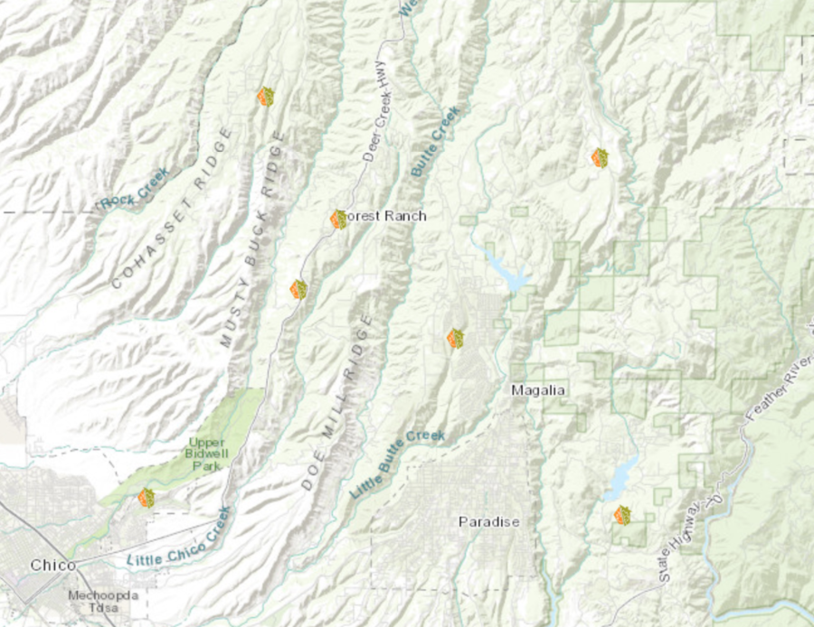
The Firewise program has an interactive map on the NFPA website with details about designated sites and their locations across the country, and it’s interesting to compare locations with known fire-danger areas. There’s a cluster of sites, for example, north of Paradise in northern California. One of the sites, Falcons Pointe Drive, is near Upper Bidwell Park in Chico. That community’s participation in the Firewise program began in September of 2022.
There are very few sites in Nevada and zero in North Dakota; about half of Colorado’s map is covered with little Firewise icons. While Oregon’s west side is not really known for severe wildfires, that side of the state surely proved the exception over the last few years, and it’s crowded with Firewise sites, while the east side of Oregon, no stranger to major fires, has only a few. Blake Ranch was just added to the list in December, and the numbers grow as people learn about neighborhoods and towns devastated by wildfires.
“The number of conversations I have had since Paradise has skyrocketed,” said Chris Chambers, Forest Division Chief in Ashland, Oregon. Residents and local officials in and around Ashland tend to be a little more fire-savvy than in many areas; they have a history with interface fires. Jefferson Public Radio reported, about a year after wildfire leveled the town of Paradise, that Chambers spoke to a throng of people at a sold-out screening of the documentary Fire In Paradise at a theater in downtown Ashland, just north of the California state line. Although the Camp Fire was more than 200 miles south, Chambers says it alarmed Ashland residents; it’s a small, woodsy town that, like Paradise, is tucked into forest.
“People have really become concerned,” Chambers said. “I just hope that translates into lasting awareness in the sense that people take responsibility for the condition of their property.”
On a windy Sunday on the west side of County Cork, Ireland, satellite hotspots were highlighting what firefighters were facing in person, with reports of nearly 100 fires breaking out in gorse and related fuels, beginning February 26 and burning into the next morning.
Burning gorse in Cashelfean, County Cork, Ireland. Photo: Cork County Council.
Significant nighttime fire growth in highly flammable gorse brush threatened a radar and aviation-control installation and involved six West Cork fire brigades and other resources, including the Irish Aviation Centre firefighters on Mount Gabriel.
Heat detection and burned area mapping from the Global Wildfire Information System highlights widespread fire ignitions on the West Cork peninsulas from Feb. 26-27, 2023.
The burning of vegetation from March 1 through August 31 is a violation of the Wildlife Acts, but a spokesperson for Cork County Council warned that intentionally set fires during last weekend’s winds threatened houses, a radar installation, livestock and wildlife, not to mention the risk to firefighters and the drawdown of resources for other emergencies.
Twitter correspondents also captured the flames.
Firefighters have been praised for saving a critical aviation radar installation from a massive wildfire last night.
The Mount Gabriel blaze was one of 20 wildfires on the Mizen & Beara peninsulas to stretch firefighting resources this weekend. #Corkhttps://t.co/AybkSQqn3Z
West Cork gorse fires came close to knocking out air traffic control radar on Mount Gabriel: Several homes were also endangered by the wildfires https://t.co/yMrZzaqp84
A decade ago, the late Bill Gabbert began writing here about the “Holy Grail of Wildland Fire Safety” – the tools, best practices and system for advanced firefighter and fire tracking – and he returned to it often.
As their letter to the President observes, “Whereas we have a national commitment ensuring that our warfighters are not sent into harm’s way without the best of American science and technology at their disposal, no similar organizational framework exists to protect and empower wildland firefighters.”
Their five recommendations lead off with this problem and an urgent push:
“Recommendation 1: Given the vulnerabilities and shortfalls in wildland firefighter communications, connectivity, and technology interoperability, immediately assess, adapt, and field currently available technologies.”
To support this, their next recommendation calls for cabinet-directed executive authority to “Reverse the current trend of rapidly growing wildfire suppression costs by establishing a joint-agency executive office (hereafter Joint Office) that can accelerate enterprise-level development and deployment of new technologies that enhance situational awareness and initial attack capabilities.”
The recommendation continues that “This Joint Office would serve to advance coordination, streamline authorities, and drive progress in enabling technology adoption across the numerous federal agencies with equities for wildland firefighting science and technology (S&T) within NIFC [National Interagency Fire Center]. It is imperative that the Joint Office leader have Cabinet-delegated decision-making authorities as well as the mandate and budget needed to develop and execute a unified technology roadmap.”
Recommendations 3, 4 and 5 would be led by the proposed Joint Office and serve to unify and expedite the “full operational sequence of wildland firefighting” with current and new technology, with inputs from NIFC, the land management agencies of DOI and USDA, and NOAA, NASA, and the Department of Defense.
While the goals are straightforward the implementation is complex, as indicated in this graphic from the report.
At the NIFC website, a search for the word “safety” produced 641 results. Hits for “technology” totaled 206, “intelligence” 121. “Location-based” yielded 24 results, though most were variations of “allocation.” The most concrete reference is to the 2023 Red Book, where there’s a reference to “Location Systems,” on page 42 of the BLM section:
“The LBS [Location-Based System] Program combines current Global Positioning System (GPS) technologies with BLM fire and aviation preparedness to provide a situational awareness tool by tracking equipment. LBS is incorporated into dispatch and other operating procedures to enhance situational awareness and accountability of WCF 600-class fire equipment. This program meets the intent of S.47 – John D. Dingell, Jr. Conservation, Management, and Recreation Act, SEC. 1114. (d) 12 Location Systems for Wildland Firefighters.”
With wholehearted respect for the BLM’s LBS program and the efforts to date, the federal location systems in their entirety seem a far (and hard to track) distance from meeting the intent of the 2019 Dingell act.
This week’s PCAST recommendations seeks to correct the “vulnerabilities and pitfalls” of our current processes and accelerate the urgency toward this decade-long search for the “Holy Grail” of location systems. It’s a race we need to win.
There’s yet another dumb hiker in the news for starting a wildfire to signal rescuers after he got lost. Philip Powers, a resident of Tempe, Arizona, argued in court that the fire he set in 2018 was necessary to save his life. But a federal court found that he was so unprepared that he created his own emergency.
Backpacker Magazine reported that the 37-year-old hiker in the rugged Sycamore Canyon Wilderness northwest of Sedona, in late May 2018, had barely slept and had muscle cramps in his legs. He’d also found a rattlesnake in the sheepherder shack where he’d overnighted. It was 14 miles back to his car, he was out of food and water, and he had no cell signal. Powers later told a USFS law enforcement officer that he feared he was “done.”
2018 Sycamore Fire in Arizona, looking north. USFS photo.
He’d tried the night before to start a signal fire, but it quickly burned out. He tried again, piling dry foliage around the base of a snag and firing it up with his Bic lighter. He hoped that the dead tree would go up in flames, and someone would see it and come to his rescue. But the fire got away, tripled in size in one day, and quickly grew to 230 acres; the Sycamore Fire took over a week to contain. A federal district court recently convicted him for his actions in 2018, and Powers now owes the feds almost $300,000 in restitution — and a year of probation.
Fronteras Desk reported that Judge Camille Bibles didn’t buy the hiker’s excuses. “Had Powers engaged in adequate preparation in planning and carried adequate water, food and gear, he would not have found himself in his circumstances,” she wrote. “Thus, the court finds that Powers’ necessity defense fails, as he created the conditions necessitating the commission of the fires, and his subsequent rescue.”
Powers faced 3½ years in prison for the seven misdemeanors he was charged with. Judge Bibles sentenced him to seven concurrent one-year probation periods instead. He also owes the Forest Service more than $293,000 in restitution, which he will make in $200 monthly payments.
In addition, the judge ordered Powers to complete a hiking safety course.
According to 12News in Arizona, he’s already filed an appeal of his conviction.
When Ed Pommerening died last Christmas Eve in Kellogg, Idaho he left a forestry legacy that is unmatched in Idaho history. I grew up in Kellogg and knew Ed mostly by reputation. We last talked by phone in 1996. I was in the middle manuscripts for an Evergreen edition featuring forests and forestry in Idaho and I wanted to include a short story about the miraculous rebirth of forests on the barren hills of my youth.
Ed is the reason Idaho’s Silver Valley between Smelterville and Big Creek is covered with countless thousands of conifers, many of them 50 feet tall. It is a stunning tribute to the dogged determination of a young man who once told me that the Kellogg he saw for the first time in 1972 reminded him of the godawful agent orange devastation he’d seen while serving with the 101st Airborne Rangers in South Vietnam.
That young man was Ed Pommerening. He was coming to Kellogg then to begin work as the Bunker Hill Company’s first forester. “Uncle Bunker” was by far Idaho’s largest industrial employer, the Union Pacific Railroad’s largest customer by tonnage, and the largest power consumer in the entire Washington Water Power system. At one time, Bunker Hill was the largest mining and smelting company in North America. It supplied most the lead we threw at the Germans and Japanese during the Second World War.
I worked my way through college in company stopes a mile beneath the streets of Kellogg. It was dangerous as hell — but great fun. I have no idea what convinced Ed that he could turn the Silver Valley’s barren hills green again — or how he convinced the company to invest in the crazy idea that he could grow countless thousands of seedlings 3,000 feet down in the mine, but in August 1975 company carpenters built Ed’s first 40-foot long underground greenhouse. One of my late father’s plumbing crews ran the water lines.
The scale of Ed’s thinking was breathtaking but the idea was not new. Many miners grew vegetables in pots in pitch black drifts with only the illumination of a single lightbulb. The air temperature was a constant 72 degrees, so all you had to add was some soil, water from a nearby drill line, a little light, and voila! It certainly helped that Ed had earned two forestry degrees from the University of Idaho. His connections would prove invaluable after his first seedlings died soon after they were transplanted on treeless hills by high school kids and civic groups.
The same thing had happened to seedlings my Cub Scout pack planted in Vergobbi Gulch in the 1950s. We never knew why, but soil scientists at the University of Idaho figured out that sulfur dioxide gas released from stacks at the Bunker smelter had polluted the soil. Acid was killing the seedlings. The solution: plant them deeper and add a dash of neutralizing potash for good measure. The beautiful result graces both sides of Interstate 90 between Smelterville and Big Creek: Ponderosa, Scotch and Austrian pine, Douglas-fir, western larch, western white pine, blue spruce, willow, and poplar.
The homesteader’s apple orchard behind our home on Mission Avenue has given way to a sea of green that turns to gold in the fall. Words seem inadequate.
A very good case can be made for the fact that the Silver Mountain Resort and Ski Area and its legendary gondola are prospering today because of Ed Pommerening’s modesty and quiet determination. Small wonder that his forestry consulting business, Riverview Timber Services, thrived for decades.
The Kellogg where I grew up is long gone: the smelter whistles that announced shift changes, the friends I made underground, Al Laramie at the piano on Friday nights at the old Sunshine Inn, and the vibrancy of Kellogg’s booming economy. We thought Bunker would go on forever. For better or worse, it didn’t. The end came in 1981. Labor strife and unattainable federal air and water quality standards were the main reasons. But Ed’s vision provided the catalyst for Kellogg’s rebirth.
The power of forestry turned the barren hills of my youth green again and my hometown has a future. There is a bronze statue of a miner at the corner of Main and McKinley Avenue in uptown Kellogg. There needs to be one of Ed standing beside him.
WATCH THE VIDEO: The Reforestation of Silver Valley is a fascinating story told by Ed Pommerening and others about an industry that took the initiative to solve a major environmental problem in northern Idaho. The video was funded by the Kootenai-Shoshone County Farm Bureau and Idaho Farm Bureau and was produced by Matthew Bane. Watch it [HERE].