Five fires are burning in the Gila National Forest

Above: A satellite detected smoke from 5 fires in the Gila National Forest in New Mexico on June 14, 2017. The red dots on the map represent heat. The acreages shown were reported within the last 48 hours.

Five wildfires burning in the Gila National Forest in southwest New Mexico are all being managed using a strategy of less than full suppression.

For example, the Round Fire is listed like this:

  • Confine (25%)
  • Full Suppression (25%)
  • Monitor (25%)
  • Point Zone Protection (25%)

There are a total of eight large wildfires in New Mexico that are uncontained and are being managed with a less than full suppression strategy. Arizona has 12 large uncontained fires, and 6 are being fully suppressed.

The Southwest Geographic area is in Preparedness Level 4 (5 is the highest possible). The National PL is 2.

round fire new mexico
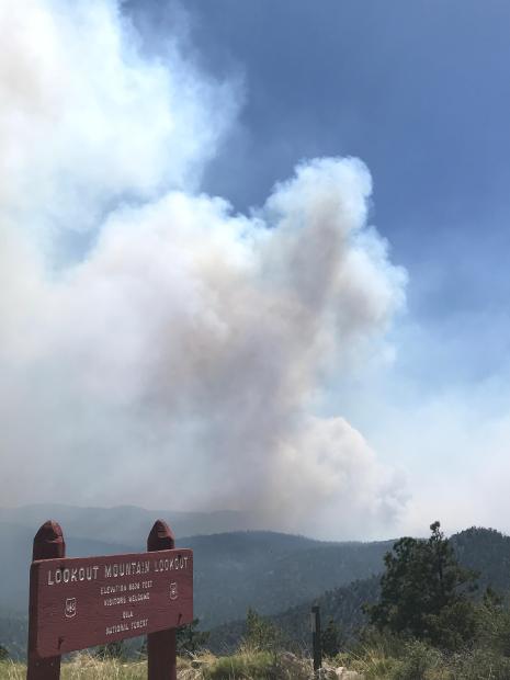
Round Fire – view from Lookout Mountain. Posted on InciWeb June 13, 2017.

NPS official talks about the wildfire that burned into Gatlinburg

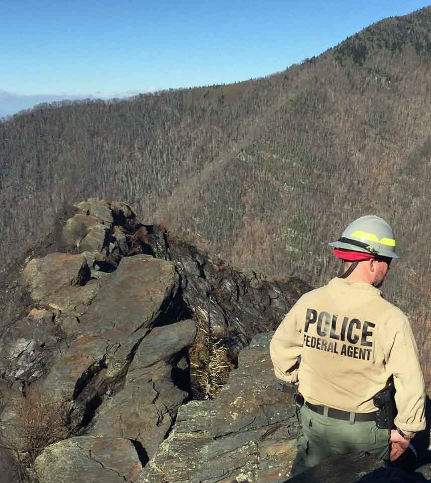
Above: Fire Management Officer Greg Salansky points toward the twin peaks (at upper left) where the Chimney Tops 2 Fire burned for five days before it spread into Gatlinburg, Tennessee. Photo by Bill Gabbert.

When a group of wildfire professionals visited Great Smoky Mountains National Park on June 7, Fire Management Officer Greg Salansky walked them through the steps he took in evaluating and managing the fire that after six days burned into Gatlinburg, Tennessee killing 14 people, forcing 14,000 to evacuate, destroying or damaging 2,500 structures, and blackening 17,000 acres. In addition to coordinating the wildland fire management activities at that park, Mr. Salansky does the same thing for 20 other National Park Service sites in the Southeast United States

Late in the afternoon on November 23, 2016 firefighters in the Park were responding to a report of a vehicle fire when they spotted a vegetation fire near the top of a steep hill called Chimney Tops. A fire in the same area a week earlier was given the name “Chimney Tops”, so this new fire became “Chimney Tops 2”.

Mr. Salansky and one firefighter hiked up a trail to the fire area but when they got close to the blaze in a very steep area the other firefighter decided that it was unsafe for her to continue so she remained at that location while Mr. Salansky continued. Working his way along a portion of the fire edge he found that the vegetation was very dense making travel through the steep, rocky terrain difficult.

investigator national park service
An investigator from the National Park Service’s Investigative Services Branch looks for evidence at Chimney Tops. NPS photo.

He tried scraping some leaves to begin a fire line, but told the group last week standing in a pull-out on the highway looking up at Chimney Tops, “Well, maybe I can go in on the north side. So I walked that ridge and the smoke laid over about chest high. I’d get in about 20 feet and the wind would let up and the smoke would come up. There was a drop off on both sides. I did that a couple of times before I figured out I shouldn’t even be here. What am I doing here? So I thought I’m done, there’s nothing I can do with it. It’s dark. It’s not safe. So I bailed off and tied in with April who was my safety, since she was smart enough not to go where I went. So we hiked back down. We’ve got a squad coming in the next day, Thanksgiving, welcome to Thanksgiving day.”

The next day, November 24 (day #2), with about six other firefighters he hiked up near the fire that occurred a week before where there is a sign reading, “From this area past it is closed.” Mr. Salansky said. “There’s been one fatality and multiple injuries that cost like $20,000 apiece. So all the folks read that and they’re like, ‘It says it’s closed and dangerous and you want us to go in and fight fire.’ ”

Continue reading “NPS official talks about the wildfire that burned into Gatlinburg”

Report released on dozer burnover in Florida

Dozer burnover Okeechobee County
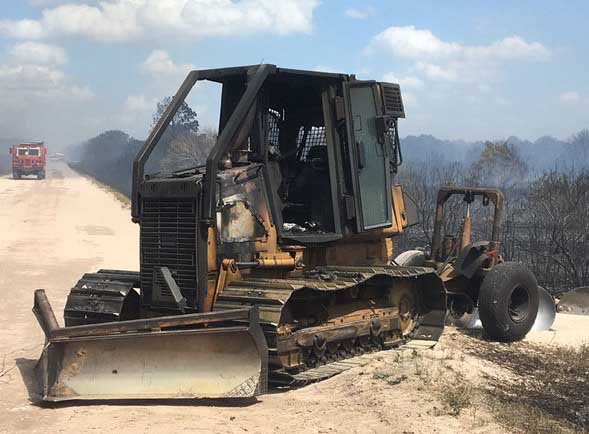
Dozer burnover in Okeechobee County, Florida. April 16, 2017. Florida Forest Service photo.

The Florida Forest Service has released a report on the burnover of a dozer that occurred April 16, 2017 in Okeechobee County. As you may remember from our April 17 article, the operator, who was not injured, became entrapped while constructing fire line with the tractor plow and was overrun by the fast-moving fire.

You can read the entire report HERE, but below are some excerpts:

****

Contributing Factors:

  • Initial tactics deployed by the first arriving units were based on limited knowledge and experience.
  • Incident Commander having minimal initial attack experience.
  • Operating equipment beyond its capabilities
  • Leaders intent, was not made clear.
  • Ineffective transfer of command to experienced leadership positions.
  • Loss of situational awareness with crews.
  • Lack of effective communication.
  • Minimal staffing in Communications Center during high fire danger.

Lessons to Share:

  • It is imperative to speak up when you are feeling uneasy, uncomfortable, or unsure.
  • Experienced firefighters should be mixed with those who are less experienced. This will necessitate a thorough briefing, ensure instructions are clear and understood and to keep firefighters from working alone when additional units are on scene.
  • Personnel accountability is extremely important, especially in complex initial attack circumstances that often require unique tactics and strategies. This helps ensure safety of all crews.
  • Operate equipment in appropriate speed settings (1.7-1.9). This will reduce equipment fatigue and failure.
  • Turn off air-condition unit if caught in flame front or heavy embers. This will help reduce the likelihood of the filters and cab catching fire.
  • Establish properly qualified and experienced leadership.
  • Incident Commander should limit his/her hands-on fire suppression activities to maintain effective situational awareness.
  • Limit radio traffic to the extent possible. This will improve the possibility that emergency traffic can be transmitted and received successfully.
  • Increase staffing in Communications Center on high fire days to help with the additional call volume and radio traffic.
  • Know and follow established policy and procedures for emergency radio traffic.

Thanks and a tip of the hat go out to Rob.
Typos or errors, report them HERE.

Seven people killed in South Africa wildfires

Above: A post-fire scene from Knysna, South Africa. Screen grab from the Times video below.

Wildfires in South Africa have killed five residents, at least one firefighter, and have forced thousands to evacuate.

One of the fires in the Van Stadens Gorge area in the Eastern Cape has reportedly reached some of the buildings at Woodridge College outside of Port Elizabeth, the school said in a Facebook post.

Numerous wildfires in Southwest Alaska

Above: A photo taken Monday of the 1,558-acre Kenakuchuk Creek Fire burning about 40 miles north of Dillingham. Photo courtesy of U.S. Fish and Wildlife Service.

Firefighters are leap frogging from one fire to another to protect villages, cabins and other structures in Southwest Alaska after more than a dozen new wildfires were started by lightning strikes in the past three days.

The Alaska Division of Forestry reports that as of Wednesday morning there are 15 active fires burning in the area, which covers an 88-million acre swath of Southwest Alaska from McGrath to Dillingham. Six of the 15 fires are staffed with firefighters while the remainder are being monitored.

The highest priority fire remains the 1,000-acre Bell Creek Fire (#161) burning less than 2 miles from the village of Crooked Creek on the Kuskokwim River, about 110 miles southwest of McGrath.

There are 49 personnel working on the fire, including eight smokejumpers from the BLM Alaska Fire Service and two initial attack crews from the Alaska Division of Forestry.

The fire doubled in size on Tuesday and was active again on Wednesday, prompting fire managers to launch air tankers for retardant drops on the south edge of the fire closest to the village in hopes of slowing its progress. The fire is backing over a ridge toward the village. Firefighters abandoned attempts at direct attack on Tuesday and are focusing their efforts on building indirect line on the north edge of the village closest to the fire. Personnel are planning to conduct burnout operations today in that area to deprive the fire of fuel if it threatens to reach the village. Firefighters will also be plumbing structures on the northern edge of the villages with pumps, hoses and sprinklers.

The Pitka Fork Fire (#160), a 6,600-acre fire burning about 60 miles east of McGrath, also received attention on Tuesday. The McGrath dispatch office received multiple reports of increased fire activity and a detection aircraft was launched to assess any potential threat. Multiple structures were identified in the area and a load of smokejumpers and two air tankers were flown to the fire for structure protection.

Tankers dropped five loads of retardant around structures on the south side of the fire and smokejumpers prepped structures with pumps, hoses and sprinklers. Weather permitting, the smokejumpers plan to conduct burnout operations today to fortify structure protection measures that were taken.

Two new lightning-caused fires – the Black River Fire (#172) and Paiyun Creek Fire (#174) – were reported in the area on Tuesday but neither posed a significant threat.

The Black River Fire (#172) was reported 38 miles south of McGrath in a full protection area. Helitack was launched from McGrath to size up the fire and reported it to be 8 acres burning in mixed hardwoods.

An air tanker dropped one load of retardant to keep the fire from spreading into a spruce stand and a helicopter was used to drop water on the fire to keep it in check while helitack personnel on the ground worked to build line around the fire. Helitack personnel secured line around 60 percent of the fire Tuesday evening and the fire received light precipitation overnight. A Type 2 crew from Lower Kalskag was shuttled into the fire on Wednesday to continue building line and mop up.

Here’s a rundown of the other fires burning in the Southwest Area:

Continue reading “Numerous wildfires in Southwest Alaska”
Nine dead in South Africa storm and wildfires

Posted on Categories UncategorizedTags

Above: The red dots indicate heat from wildfires in South Africa detected by a satellite on June 7, 2017 . Much of the smoke is obscured by clouds, but it can be seen further to the southeast when it emerges out of the cloud layer. NASA data.

Large wildfires and an associated storm in South Africa have killed at least nine people, according to Western Cape local government spokesman James Brent Styan. A storm system brought very strong winds to the area which resulted in flooding in Cape Town while lightning and winds further to the east have caused fires near Knysna and Plettenberg Bay.

The Weather Channel reports that four of the deaths occurred in a fire caused by lightning, and one other person died when a home collapsed. Three others died in a separate fire. Approximately 10,000 residents have been evacuated.