Person suspected of stealing solar panel and battery from Oregon DOF fire camera system August 14, 2022.
From the Jackson County, Oregon, Sheriff’s Office, August 16, 2022:
Jackson County Sheriff’s Office (JCSO) is investigating the theft of Oregon Department of Forestry (ODF) equipment stolen from a lookout tower in the Prospect area (map). Two men broke into the tower on Sunday afternoon August 14, 2022 around 12:45. The thieves stole batteries and solar panels used to power the lookout tower’s fire detection camera. With these items stolen, the camera is no longer operational, leaving a hole in the camera network and taking away the opportunity for early fire detection.
The ODF Southwest Oregon Detection Center is a system of cameras across Jackson and Josephine counties used to monitor rural areas in an effort to catch fires at a small size, provide critical fire information to firefighters responding to active incidents, and allow the department to use resources more strategically. This particular tower enables early fire detection for the northeastern portion of Jackson County near Prospect. ODF is currently working as quickly as possible to get the camera system back up and running. The list of items stolen includes batteries and solar panels to power the cameras.
If you can identify the subjects in the video and photos or have any information about the theft please call the JCSO Tip Line at (541) 774-8333 and reference case # 22-4725.
Solar panel that was stolen from Oregon DOF fire camera system August 14, 2022.Person suspected of stealing solar panel and battery from Oregon DOF fire camera system August 14, 2022.
There is also a video on Facebook showing two people climbing the stairs to the lookout.
“As soon as we found out, we started re-ordering all of the batteries, solar panels and specialty pieces that make this system run, but the bad news is a lot of these things are hard to come by and shipping can take some time,” said the Oregon DOF. “Getting the site back up and running is one of our top priorities, but in the meantime, we have firefighters out patrolling the area to make sure we’re still finding fires quickly and keeping them small.”
Red Fire 3-D map, looking south at 12:35 p.m. Aug. 14, 2022.
The Red Fire in Yosemite National Park in California has burned 416 acres since it started from a lightning strike on August 4, according to a mapping flight Monday morning. It is in a remote and rugged section of the park about 12 miles northeast of Wawona and the Washburn Fire which burned nearly 5,000 acres very close to the Mariposa grove of giant sequoias in July.
The national Situation Report Monday morning showed a small group of resources assigned — five people with one fire engine. They are being led by Jenn Anderson, a Type 4 Incident Commander.
The crew is assessing natural barriers, such as granite, to confine and contain the fire, rather than fully suppress the blaze. There are no trail closures or threats to infrastructure.
Red Fire map, 12:35 p.m. Aug. 14 2022.
It is very close to the Mariposa/Madera County line and about five miles from the park boundary. So far the fire has been burning at about 8,300 feet above sea level, mostly in the footprint of the 2001 Hoover Fire. If it spreads further to the east it will leave that fire scar and move into an area with no fire history within the last 30 years, but there is a great deal of granite in that direction. (see the 3-D map at the top of the article) There are no giant sequoia groves within several miles of the fire, which was a major concern during last month’s Washburn Fire.
Red Fire, image by FIRIS mapping aircraft. Looking west at 8:53 a.m. PDT Aug. 15, 2022.
A satellite flyover at 1:38 p.m. PDT Monday detected only a few large heat sources, all on the east half of the fire. There are no doubt many smaller burning areas that could not be detected by the sensors orbiting hundreds of miles above the Earth.
Red Fire, posted August 13, 2022 by Yosemite National Park.Red Fire, posted August 14, 2022 by Yosemite National Park.
From the National Park Service, Yosemite National Park, August 12, 2022:
“We are sad to report that pioneering Yosemite scientist Jan van Wagtendonk died on July 15, 2022.
“Jan was a Yosemite and National Park Service legend: an accomplished scientist, a preeminent fire ecologist, a wilderness advocate, and a beloved colleague. He was an innovative wilderness manager, coming up with the trailhead quota system that we still use today to protect wilderness while ensuring that hikers are free to enjoy that wilderness on their own terms. His impact affects fire policy to this day as one of the authors of the first federal fire policy in 1995. Jan possessed an amazing intellect, deep humility, a sharp wit, and a profound love of Yosemite and the Sierra Nevada.
“Jan was a strong advocate for returning fire to the Sierra landscape. His pioneering use of prescribed fire in the early 1970s in and around the Mariposa Grove started us on the path to reestablishing an ecological balance lost in over 100 years of fire suppression. There is poetry, in the words of Jan’s son Kent, that in Jan’s final days the fruits of those efforts had a direct and dramatic effect in saving the Mariposa Grove from the Washburn Fire, which started just outside of the grove.
“Our heartfelt condolences go to Jan’s family and wide circle of friends and colleagues. He was one of a kind, and will be deeply missed.”
The article below from the US Geological Survey was originally written in 2020, based on an interview with Jan van Wagtendonk in 2019:
The first thing to know about emeritus scientist Jan van Wagtendonk is that he loves trees—always has and always will. As a kid, he looked at trees, inventoried trees, wrote a report on trees. One of his neighbors as a kid described young Jan by saying “I never saw him inside.”
He was a forest scientist before he even knew that was a thing you could be.
At age 13, van Wagtendonk was on two-months long family camping trip when he met a forest ranger. Upon realizing that he, too, could work with trees for a living, van Wagtendonk decided to become a forester. Several years later, he entered the forestry school at Purdue University in Indiana.
Wildfire 101
One day in college, van Wagtendonk found a listing on a campus bulletin board for a summer job on a wildland firefighting crew in Oregon. He applied, got the job, and headed West. It was his first experience with wildfire, the subject that would become his life’s work. Unsurprisingly, he loved Oregon—it had great trees—and ended up transferring to Oregon State University. He would spend several summers on fire crews in Oregon and then Alaska, first mopping up the final embers of wildfires and later working as a smoke jumper. The job was to put the fires out. Years later, his job became more about the opposite—reintroducing fire to Western forests.
Van Wagtendonk claims he “had no inkling about fire ecology at all” at the time, but he thinks that several experiences he had during his smoke jumping days may have shaped his thinking as a forest scientist and led him to fire ecology. In one instance, he was assigned to a put out a fire in a remote part of Alaskan tundra. The landscape was dotted with bird nests. The flames were about two inches high, and the fire crept along at about a foot per minute. Van Wagtendonk was struck by the birds’ seemingly nonchalant reaction to the fire: “the fire would be coming, they’d go up like this”—he mimes a bird flapping its wings and rising into the air a few inches as he tells this story— “fire’d go by, and they’d go right back on the nest.”
Many wildfires, he found, were not destructive. They burned slowly, part of the landscape.
After graduating from Oregon State University, van Wagtendonk served in the army as an officer in the 101st Airborne Division and as an advisor to the Vietnamese army. But after four and a half years, he was ready to move on and applied for graduate school, eventually ending up studying fire ecology under Dr. Harold Biswell at UC Berkeley.
Bringing Fire Back to the Forest
Van Wagtendonk began his study of fire ecology just as it was coming into its own as a field and taking forestry by storm. When van Wagtendonk was an undergraduate forestry major, fire ecology was only obliquely mentioned.
Dr. Harold Biswell (L) and Jan van Wagtendonk NPS sit against a ponderosa pine near a prescribed fire in 1970 in Yosemite National Park. Van Wagtendonk’s dissertation work on prescribed fire in Yosemite around this time led to prescribed burning guidelines still in use in Yosemite today, and a long career in forest and fire science with the federal government.
At the time, he says, “fire had not been truly accepted as an academic discipline, certainly not something you tell people you’ll set.”
Biswell, van Wagtendonk’s graduate school mentor, was something of an outlier. Biswell would conduct prescribed burns and then take students, scientists, ranchers, land managers, and interested citizens out into the field and show them what he was doing.
Those efforts paid off. By 1968, the year that van Wagtendonk began his doctoral dissertation, lessons from fire ecology were starting to reshape federal fire management policy. The National Park Service, in particular, began incorporating prescribed fire programs in recognition of the ecological role of wildfire; other agencies followed suit in the decade that followed.
Van Wagtendonk’s dissertation research played a major role in this transition. Biswell’s guidance for prescribed burning was based on experience.
“He could go out in the woods and snap a twig and say, okay it’s ready to burn,” as van Wagtendonk tells it. That method wouldn’t do if prescribed burning was to be adopted more broadly. For his dissertation, van Wagtendonk set out to quantify Biswell’s prescriptions. Van Wagtendonk conducted his work at Yosemite National Park after being turned down by the Forest Service. The result? A set of guidelines for prescribed burning that are still in use in Yosemite today.
From Wilderness Management to Megafires: A Career at Yosemite
Soon afterwards, van Wagtendonk was offered a job at Yosemite—and 48 years later, he’s still there, first as an employee and now as an emeritus. The decades have brought changes—to fire ecology, to the park, and to federal government science–and lots of fascinating research about fires, forests, and the way people engage with wild places.
In the 90s, van Wagtendonk moved from the National Park Service to the USGS along with many other federal scientists, keeping his home base at Yosemite. He was among the original scientists of the USGS Western Ecological Research Center that served on the founding Science Council under its first Director, Anne Kinsinger, who is currently the USGS Associate Director for Ecosystems. That Council helped form the Center into the outstanding scientific institution that it is today.
Van Wagtendonk’s research over the years has touched on many aspects of fire science. He has developed methods for mapping fuel types, assessed the effects of fire suppression and fuel treatments like prescribed fire, analyzed patterns of lightning strikes, and studied the influence of fire on owls and small mammals. Over the years, van Wagtendonk has incorporated new technology and methods to the study of fire and wilderness, including GIS, remote sensing, and computer modeling, not only using these tools but also publishing highly-cited guidance on using these tools for fire science.
Van Wagtendonk’s work hasn’t been limited to fire research. Early on in his time at Yosemite, he began to study recreation in the park, especially in its backcountry wilderness areas. Backcountry had increased drastically in the 1960s and ‘70s. Van Wagtendonk described the changes in a 1981 paper, writing that in 1972, managers found trampled vegetation, eroded trails, and up to 200 people camped at popular sites. In the 1970s, the park implemented mandatory permit and quota systems for backcountry use that were informed by van Wagtendonk’s research.
Van Wagtendonk has witnessed Yosemite and fire science shift over the decades. In several publications, he’s traced the history of fire policy and management in Yosemite and beyond. Visitor numbers have skyrocketed at Yosemite, and larger wildfires burn in California as the climate warms. In the past two decades, his research has given more attention to today’s megafires and climate change. There’s still a lot to learn about the future of fire.
It can take a long time for new science to really shape management on the ground, but van Wagtendonk marvels at how far we have come, and how much the still-young field of fire ecology has influenced policy already.
“It has been very gratifying to see my work actually be used in park management and beyond,” he says.
Van Wagtendonk has been in Yosemite for 48 years, and still can’t get enough of it. When he’s not working on his writing and research, he loves to hike and backpack the trails.
“I’ve hiked every trail in the park,” he says. “I’ve been backpacking every summer. . . I’m at the point where I’m going back to places I’ve liked the most . . .but I want to be able to keep doing that as long as I can, do it now before my legs give out.”
Jan van Wagtendonk in the Mariposa Grove, Yosemite National Park, approximately 2019. USGS photo.
Thanks and a tip of the hat go out to Jim, Gerald, and Kelly.
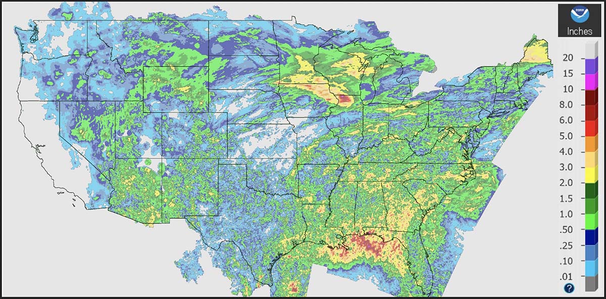
Precipitation, during the seven days ending at 11 a.m. MDT August 13, 2022.
It seemed to me that over the last few weeks the wildfire activity has been slower than typical for this time of the year, so I did a little digging. Using historical data from the National Interagency Fire Center and acres burned to date from the August 13 national Situation Report, it turns out that Alaska has burned nearly three times their 10-year to-date average while the other 49 states combined are running 12 percent below the to-date average.
Over the last 10 years Alaska’s average acres burned in a full year is 1.1 million. This year they are at 3.1 million, more than the other 49 states combined. There has been a major increase in Alaska acres burned after mid-August in only 2 of the last 18 years. And it has been fairly quiet there, fire wise, for the last four weeks.
So far this year, fires in the other 49 states have blackened about 2.8 million acres, 12 percent below the to-date 10-year average of 3.2 million. The 49 states typically burn 6.2 million in a full year, so if this year turns out like the average of the last 10, we’re about half done.
The Situation Report does not break out data for Alaska and the other 49 states, so just looking at their 50-state numbers a person would see that the 5.9 million acres burned to date is 27 percent higher than the average of 4.3 million, when actually the +27 percent figure is very wrong for both Alaska and the lower 49 states.
We usually separate Alaska stats because fires in that huge state are managed far differently from the other 49. Most of them are not fully suppressed since they are less likely to endanger people or private property than in the lower 49 states. The second reason is that the fire occurrence is extremely variable, with the acres burned since 1990 ranging, for example, from 43,965 acres in 1995 to 6,645,978 in 2004. Including the Alaska numbers in the total would skew the data for the other 49 states making it more difficult to spot trends.
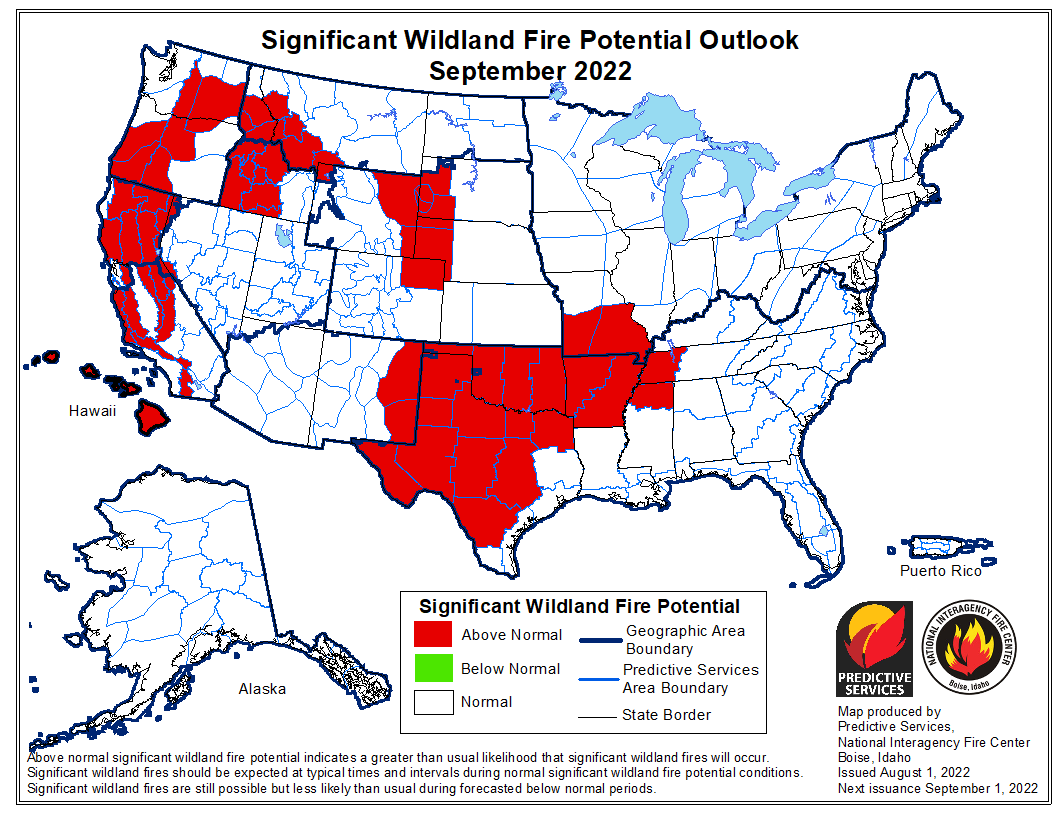
Wildland fire potential for September, 2022. NIFC.Wildland fire potential for August, 2022. NIFC.
More accurate mapping on Friday found that the Leilani Fire on Hawaii’s Big Island was not as large as the earlier 25,000-acre estimate, and had instead burned 16,400 acres as of Friday afternoon. Fire officials said it was about two miles from Highway 190.
From BigIslandNow, August 12 at 3:41 p.m. HST:
“The last two days the fire was mostly burning in invasive fountain grass. It’s the first plant that comes in after fire disturbance,” said Steve Bergfeld, the Hawaii Island Branch Manager for the Hawaii Department of Land and Natural Resources Division of Wildlife, and one of three incident commanders on the fire. “Unfortunately, the fire has moved into some dryland forest which has native ōhiʻa lehua and we are trying to keep flames away from this sensitive area.”
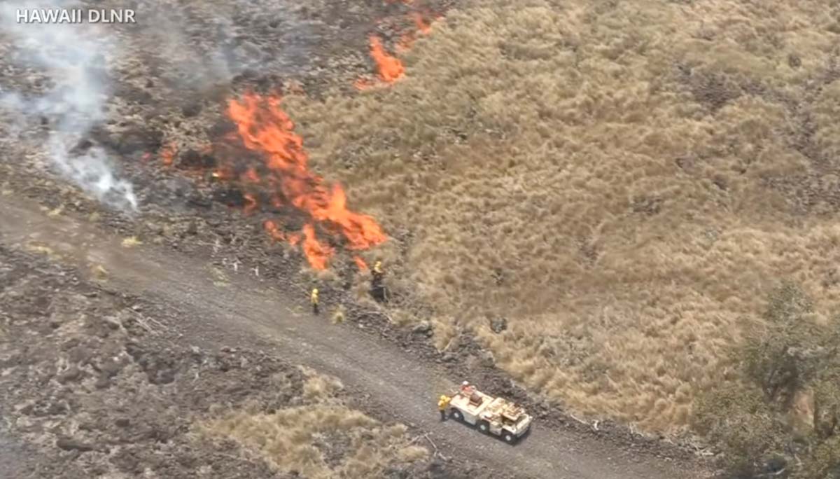
Seven contracted bulldozers left a fire command post this morning, leading the way into the fire area, where the heavy machines continued building wide fire lines. Five helicopters from the U.S. Army’s Pōhakuloa Training Area are conducting aerial water drops. It’s hoped this all-out assault on the Leilani fire will result in firefighters gaining the upper hand in the next few days.
The video below was shot Friday August 12 by the Hawaii Department of Land and Natural Resources (DLNR).
The photos below are still images from DLNR videos.
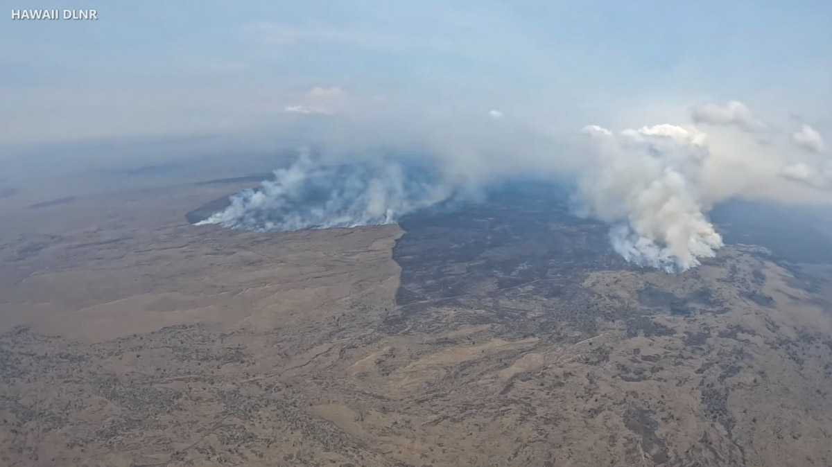
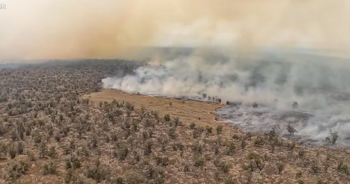
Leilani Fire on Hawaii’s Big Island. Image from Aug. 12, 2022 DLNR video.
Leilani Fire on Hawaii’s Big Island. Image from Aug. 12, 2022 DLNR video.
Leilani Fire on Hawaii’s Big Island. Image from Aug. 12, 2022 DLNR video.
Leilani Fire on Hawaii’s Big Island. Image from Aug. 12, 2022 DLNR video.
Leilani Fire on Hawaii’s Big Island. Image from Aug. 12, 2022 DLNR video.
Leilani Fire on Hawaii’s Big Island. Image from Aug. 12, 2022 DLNR video.
Leilani Fire on Hawaii’s Big Island. Image from Aug. 12, 2022 DLNR video.
12:01 p.m. PDT August 12, 2022
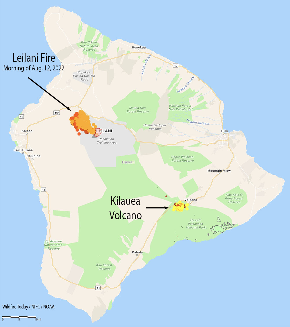
Map of the Leilani Fire. The red and tan dots represent heat detected by a satellite early in the morning Aug. 12, 2022. The small red perimeter was the extent of the fire on July 22, 2022.
A fire in Hawaii that the Hawaii Department of Land and Natural Resources (DLNR) said has been burning for weeks has suddenly become much more active. The Leilani Fire started in the US Army’s Pohakuloa Training Area on the Big Island and was mapped July 22 at 2,362 acres. Recent strong winds and extremely dry conditions have helped it spring back to life and was reported Thursday evening to be 25,000 acres.
Satellite heat detections early Friday morning appeared to show it has advanced out of the Department of Defense training area and spread northwest onto state land, approaching the Daniel K. Inouye Highway (Highway 200). State officials said it was about a mile south of Hawaii Belt Road (Highway 190).
Leilani Fire, image from video by Hawaii Department of Land and Natural Resources.
Officials with the DLNR said Thursday it was not threatening any homes but dry fuels and winds gusting up to 30 mph are making it difficult to contain the blaze. It is burning through brush and grass dessicated during the drought.
A spokesperson for the Army told The Associated Press that while there is active military training in the area, the cause of the fire remains under investigation.
Leilani Fire, image from video by Hawaii Department of Land and Natural Resources.
“There are units up there training, I can’t confirm or deny if live fire was taking place,” said Michael O. Donnelly, chief of external communications for the U.S. Army Garrison Hawaii. “It’s business as usual, but the exact cause we don’t know.”
Leilani Fire, image from video by Hawaii Department of Land and Natural Resources.
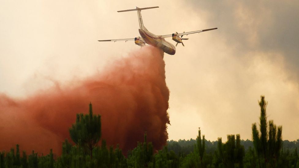
A Q400 drops retardant on a fire in France. Reuters.
The number of acres burned this year in France through mid-August, 148,000, is six times the full-year annual average over the last 15 years. Currently there are eight large fires in the country.
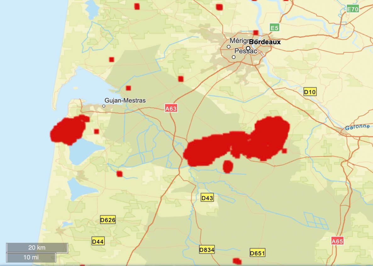
In the southwest, the Gironde region south of Bordeaux has been especially hard hit. One of the fires started a month ago and burned 14,000 acres. It was thought to be controlled, but officials said it either “reignited” on Tuesday or arson may have played a role. Since then it has blackened an additional 18,000 acres, destroyed or damaged 17 homes, and prompted about 10,000 residents to evacuate.
It has forced the closure of the A63 motorway, a major route to Spain between Bordeaux and Bayonne.
The difficulty in suppressing the fires is being attributed to record-breaking drought, strong winds, and high temperatures occasionally hitting 104 Fahrenheit in the southwest.
The red areas represent heat detected at wildfires in France in the Gironde region south of Bordeaux during the 31-day period ending August 12, 2022. FIRMS.
International assistance is coming in the form of 65 firefighters from Germany, others from Romania, Austria, and Poland, and water scooping air tankers from Greece and Sweden.
Dozens of firefighters from Romania are assisting France
France has a fleet of nine S-2 air tankers and has purchased six Q400 MR air tankers, with at least four having been delivered.
There is also large fire in the mountainous Serra de Estrela park in central Portugal, where 24,000 acres have burned. It is being fought by about 1,500 firefighters.
The red areas represent heat detected by satellites in Portugal’s Serra de Estrela Natural Park during the 7-day period ending August 12, 2022.