Smoke mixes with clouds in Alberta

smoke - clouds Alberta
Photo: NOAA/NASA

The photo shows smoke from the huge fire at Fort McMurray, Alberta mixing with clouds. The image was acquired Monday May 9 by the Suomi National Polar-orbiting Partnership satellite and NASA’s Aqua satellite.

To see the most current smoke reports on Wildfire Today, visit the articles tagged “smoke” at https://wildfiretoday.com/tag/smoke/

NIFC mobilizes air tankers to assist Canada

Posted on Categories UncategorizedTags , ,
A BAe-146 air tanker dropping on a recent wildfire in Canada.
A BAe-146 air tanker dropping on the Kenora #18 Fire in Canada. Photo by Chris Sherwin.

This article was first published on Fire Aviation.

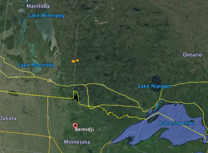
The National Interagency Fire Center has mobilized two BAe-146 air tankers and one King Air lead plane to assist the Canadian provinces of Ontario and Manitoba. Tankers 10 and 41 will be working out of the air tanker base at Bemidji, Minnesota 86 miles south of the US/Canadian border.

The aircraft were ordered primarily for the Kenora #18 Fire that straddles the border between Manitoba and Ontario (the brown dots in the map below). But they could be used for fires in either province.

According to the U.S. National Interagency Fire Center, Canada has not requested U.S. assistance specifically for wildfires in Alberta. The aid, they said, was requested through a bilateral firefighting assistance agreement with the Canadian Interagency Fire Center (CIFC). At this time, Canada has not requested additional resources or assistance from the U.S., though NIFC and the CIFC are frequently communicating.

Map Ontario Manitoba US

Pressure for a “CNN deployment” to Alberta

I have seen chatter in recent days, here and elsewhere, very critical of both the United States for not sending firefighters to help out with the large wildfire in Alberta, and of Canada for not asking for help. Alberta Wildfire Management has said they have enough firefighting resources and don’t need international assistance. We checked with Jennifer Jones, a spokesperson for the U.S. Forest Service at the National Interagency Fire Center, and she confirmed that the United States government has not been asked by Canada for any resources.

It is unfortunate that this natural disaster has turned into a political football in some circles. Generally wildland firefighters are isolated from politics, other than depending on politicians for funding and occasionally succumbing to pressure to put air tankers in the sky even though they know that in certain conditions they will be completely ineffective. Firefighters call the retardant delivered to a fire under those conditions “CNN drops” — made for television — simply to appease the public and reduce the pressure felt by politicians. Thankfully CNN drops are rare.

But this pressure to send United States firefighters or hardware to Alberta falls into that same category. It would be a CNN deployment. Photos would be taken of firefighters boarding planes headed north, and then lining up at an Incident Command Post in Alberta. 

The fire management personnel in Canada say they’ve got this. The United States, Russia, Mexico, Australia, Taiwan, Israel and the Palestinian Authority all offered help, according to John Babcock, a Global Affairs Canada spokesperson, but it is not needed.

Canada and the U.S. have often helped each other out, lending ground personnel and aircraft back and forth to assist during unusually busy wildfire seasons. There is no hesitancy to do this. People criticizing politicians and fire management personnel about a perceived lack of sharing need to calm down. Let the professionals decide what they need and don’t need. To a firefighter, a fire is not an emergency. It’s what they do.

If Alberta needs help, they’ll ask for it. If they ask, the U.S. will send resources north.

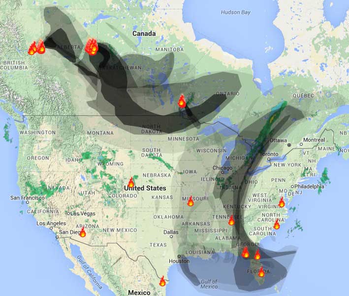
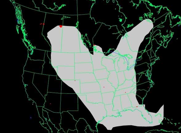
Wildfire smoke from Canada affects much of the United States, May 8, 2016

(UPDATED at 4:30 p.m. MDT, May 8, 2016)

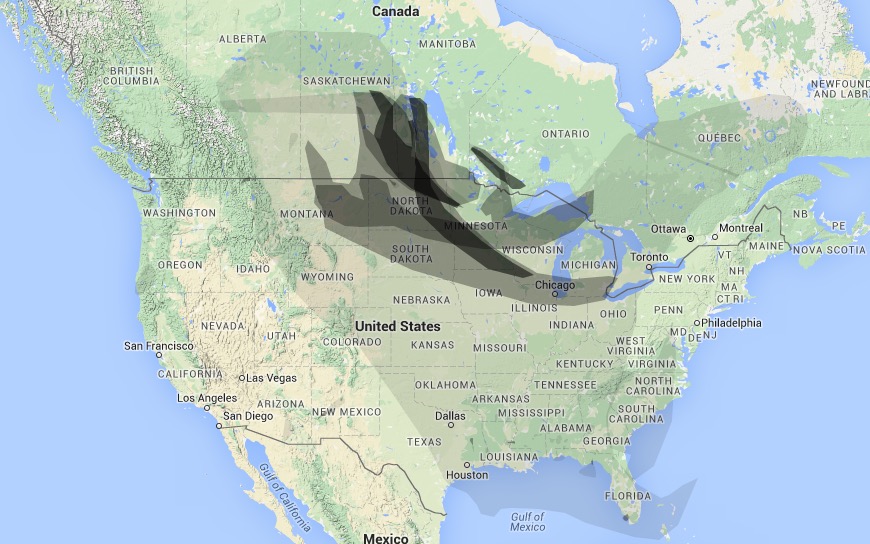
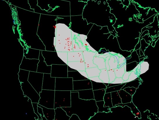
These first two maps are updated versions of the wildfire smoke maps down below. The smoke has gotten a little closer to the northeast United States.

Wildfire Smoke map
Wildfire Smoke map, Weatherunderground, 4:30 p.m. May 8, 2016
Wildfire Smoke map
Wildfire Smoke map, NOAA 3:17 p.m. May 8, 2016

****

(Originally published at 12:31 a.m. MDT, May 8, 2016)

Wildfire smoke
Wildfire smoke, at 12:05 a.m. May 8, 2016. WeatherUnderground

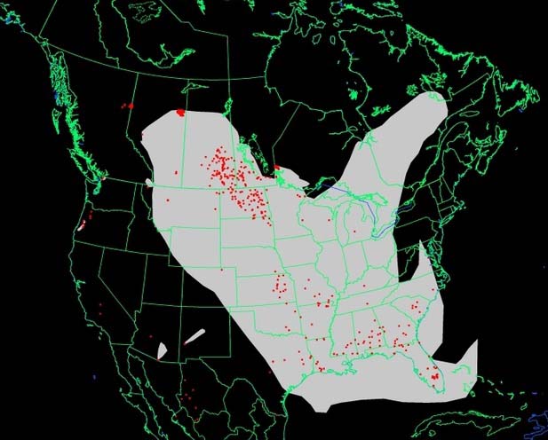
The fires in Alberta, Canada continue to create smoke that drifts into into Saskatchewan, Manitoba, the central United States, and many areas in the eastern U.S.

Wildfire smoke
Wildfire smoke map generated at 10:24 p.m. May 7, 2016. NOAA.

To see the most current smoke reports on Wildfire Today, visit the articles tagged “smoke” at https://wildfiretoday.com/tag/smoke/

Owners watched on their smart phone as their Fort McMurray home burned

The homeowners gave Storyfull News permission to post this video. Apparently the home in Fort McMurray, Alberta had a security camera with a live feed over the internet.

More information about the huge fire at Fort McMurray, Alberta that at the last count has burned about 1,600 structures and 387,000 acres (157,000 hectares).

The Red Cross is accepting donations to assist the victims of the fire that tore through Fort McMurray

Smoke from Alberta fires affects the U.S., May 7, 2016

Wildfire smoke map May 7, 2016
Map of wildfire smoke. WeatherUnderground at 9:20 a.m. May 7, 2016

The fires in Canada, primarily the 387,000-acre blaze at Fort McMurray, Alberta, continue to send smoke into Saskatchewan, Manitoba, the central United States, and many areas in the eastern U.S.

Wildfire smoke map May 7, 2016
Map of wildfire smoke. NOAA, 8:43 a.m. May 7, 2016

In the animation below, the fire is near the center of the image. From the left you can see clouds coming in from the northwest.

There is a report of smoke in Iowa:

To see the most current smoke reports, visit the articles tagged “smoke” at https://wildfiretoday.com/tag/smoke/