The Central and Bush Fires in the Phoenix Area, June 21, 2020.
(UPDATED at 10:52 a.m. MDT June 20,2020)
Friday night’s mapping flight determined that the Bush Fire had burned 174,397 acres, an increase of 23,397 acres in 24 hours.
For all articles on Wildfire Today about the Bush Fire northeast of Phoenix including the most recent, click here.
(UPDATED at 8:23 a.m. MDT June 19, 2020)
The red line was the perimeter of the Bush Fire detected by a mapping flight at 11:18 p.m. MDT June 18. The yellow line was the perimeter detected by a mapping flight at 11:49 p.m. MDT June 17. The red dots represent heat detected by a satellite at 3:24 a.m. MDT June 19.
The fire has grown to 151,075 acres.
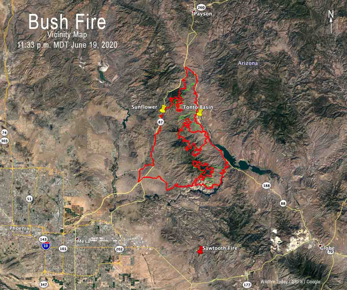
(UPDATED at 8:04 p.m. MDT June 18, 2020)
The red line was the perimeter of the Bush Fire detected by a mapping flight at 11:49 p.m. MDT June 17. The yellow line was the perimeter detected by a mapping flight at 11:12 p.m. MDT June 16. The red dots represent heat detected by a satellite at 3 p.m. MDT June 18.
(UPDATED at 7:42 a.m. MDT June 18, 2020)
Vicinity map for the Bush Fire, 11:49 p.m. MDT June 17, 2020.The red line was the perimeter of the Bush Fire detected by a mapping flight at 11:49 p.m. MDT June 17. The yellow line was the perimeter detected by a mapping flight at 11:12 p.m. MDT June 16. The red dots represent heat detected by a satellite at 2:54 a.m. MDT June 18.
For all articles on Wildfire Today about the Bush Fire northeast of Phoenix including the most recent, click here.
(UPDATED at 7:25 p.m. MDT June 17, 2020)
The red line was the perimeter of the Bush Fire detected by a mapping flight at 11:12 p.m. MDT June 16. The yellow line was the perimeter detected by a mapping flight at 12:45 a.m. MDT June 16. The orange and red dots represent heat detected by a satellite on June 17.
(UPDATED at 9:20 a.m. MDT June 17, 2020)
Map of the Bush Fire at 3 a.m. MDT June 17, 2020. Data from USFS mapping flight and NASA satellites.3-D map of the Bush Fire at 3 a.m. MDT June 17, 2020. Data from USFS mapping flight and NASA satellites.
For all articles on Wildfire Today about the Bush Fire northeast of Phoenix including the most recent, click here.
Map showing the approximate location of the Bush Fire at 2:28 p.m. MDT June 16, 2020. It is based on heat detected by satellites. This unofficial map should not be used to make decisions about safety or evacuation.Map showing the approximate location of the north side of the Bush Fire at 12:50 pm MDT June 16, 2020.3-D map showing the perimeter (in red) of the Bush Fire looking northeast at 11:46 p.m. MDT June 15, 2020. The yellow line was the perimeter 24 hours before.Map showing the perimeter of the Bush Fire (in red) at 11:46 p.m. MDT June 15, 2020. The yellow line was the perimeter 24 hours before.
A mapping flight Monday night at 11:46 determined that the Bush Fire had burned 64,513 acres.
GOES-17 satellite photo of the Bush Fire northeast of Phoenix at 6:56 p.m. MDT June 15, 2020.3-D Map of the Bush Fire northeast of Phoenix looking southwest. The red line was the perimeter at 11:25 p.m. MDT June 14, 2020. The green line was the additional growth through 1:24 pm MDT June 15, 2020.Map of the Bush Fire northeast of Phoenix. The red line was the perimeter at 11:25 p.m. MDT June 14, 2020. The green line was the additional growth through 1:24 pm MDT June 15, 2020.
3-D Map of the Bush Fire northeast of Phoenix looking southwest. The red line was the perimeter at 11:25 p.m. MDT June 14, 2020. The green line was the additional growth through 1:24 pm MDT June 15, 2020.
Monday afternoon the Incident Management Team on the Bush Fire announced that it had burned 37,900 acres.
For all articles on Wildfire Today about the Bush Fire northeast of Phoenix including the most recent, click here.
(UPDATED at 3:13 p.m. MDT June 15, 2020)
Map showing the perimeter of the Bush Fire at 11:25 p.m. MDT June 14, 2020.
Here is a zoomed-in version of the map showing the location of the Bush Fire northeast of Phoenix at 11:25 p.m. MDT June 14, 2020. The data is from a fixed wing mapping aircraft.
For all articles on Wildfire Today about the Bush Fire northeast of Phoenix including the most recent, click here.
(UPDATED at 1:13 p.m. MDT June 15, 2020)
Bush Fire, northeast of Phoenix, June 14, 2020. Inciweb photo.
At 9:46 a.m. MST on Monday a notice from the Gila County Sheriff’s Office said, “The Tonto Basin and Punkin Center area are being evacuated. If you need to travel into the evacuated areas to remove livestock and or property you will be allowed to do so.”
A notice from the Sheriff’s office also reported, “Highway 87 from the Bush Highway M/P 199 north bound and south bound to BIA 101 entrance to the Matazal Casino in Payson is closed due to the fire on Highway 87. Only local traffic will be permitted. Residents in the local areas i.e. Rye, Gisela, Deer Creek, Ox Bow will be permitted to travel into Payson and return home. The Junction of Highway 87 and Highway 188 is closed. Highway 188 to the Roosevelt Dam is closed.”
The weather is not helping the firefighters. The forecast for the fire area on Monday is for temperatures of 81 to 91, relative humidity 12 to 17 percent, and no chance of rain. The winds will become southwesterly at 6 to 15 mph by the late morning/early afternoon. Gusts of 20-25 mph will occur over most of the mountain range, but ridgetops could see gusts nearing 30 mph. Monday night the winds will be southwest at 5 to 10 mph.
(UPDATED at 7:10 a.m. MDT June 15, 2020)
Bush Fire Permeter at 11:25 p.m. MDT June 14, 2020.Bush Fire northeast of Phoenix, Arizona. Photo by James Stamsek, June 14, 2020.
The Bush Fire was mapped at 36,257 acres Sunday night. We will post more about this fire later.
(Originally published at 9:36 a.m. MDT June 14, 2020)
Map showing the approximate location of the “Bush Fire” north of Mesa, Arizona. If light fuels burned and then cooled before being detected by the next satellite overflight, the fire could be larger than shown.
Both lanes of State Route 87 are closed northeast of Phoenix, Arizona due to a vegetation fire that was unfortunately named “Bush Fire”.
The northbound lanes are closed at Bush Highway at milepost 199, according to the Arizona Department of Transportation. The southbound highway is currently closed at State Route 188.
There is no estimated time to reopen. Drivers are encouraged to use an alternate route, such as US 60 and SR 188 through Globe, or delay travel if possible.
Bush Fire, June 13, 2020. Tonto National Forest photo.Bush Fire, June 13, 2020. Tonto National Forest photo.
Map of the Mangum Fire. Heat data mapped at 9:12 p.m. June 13, 2020. The yellow line was the perimeter 28 hours before.
On Saturday the Mangum Fire burned very close to the small community of Jacob Lake, Arizona. During a 9:12 p.m. MDT mapping flight the fire was detected just west of the town very close to a campground and a U.S. Forest Service work center on Road 461. At that time it was less than a half mile from other facilities near the intersection of highways 89A and 67, an area with more campgrounds, an inn, and a Forest Service visitor center.
3-D map of the Mangum Fire, looking west with heat data mapped at 9:12 p.m. June 13, 2020. The yellow line was the perimeter 28 hours before.
By 10 p.m. the GOES-17 satellite orbiting 22,200 miles above the Earth could no longer detect a large area of intense heat as seen in the photo below taken at 6:56 p.m. MDT Saturday. The temperature at a nearby weather station dropped to 42 degrees at 4 a.m. Sunday and overnight the wind was nearly calm after midnight. But the humidity remained low, rising from a low Saturday afternoon of 9 percent, to 29 percent by 6:47 a.m. Sunday. The fire is at high elevation, 7,000 to 8,000 feet.
The National Weather Service in Flagstaff has issued a Red Flag
Warning for the fire area Sunday due to strong winds and low relative humidity, in effect from noon to 7 p.m. MST Sunday evening. The forecast calls for a high of 79 degrees, RH of 9 percent, and 10 to 18 mph winds out of the southwest gusting at 24 to 28 mph. Similar conditions are expected for Monday. These conditions could continue to threaten Jacob Lake, which is under an evacuation order.
A Fire Weather Watch has also been issued for Tuesday due to strong winds and low relative humidity.
(UPDATED at 7:21 p.m. MDT June 13, 2020)
As clouds cleared out and pushed to the north, heat and smoke from the Mangum Fire was photographed by the GOES-17 satellite at 6:56 p.m. MDT June 13, 2020.
(Originally published at 4:46 p.m. MDT June 13, 2020)
3-D map of the Mangum Fire, looking east. Data (in red) from 1:04 a.m. MDT June 13, 2020. The yellow line was the perimeter 24 hours before. Wildfire Today.
Pushed by winds gusting up to 30 miles an hour, the Mangum Fire ran for an additional 8 miles to the north-northeast Friday. Creating spot fires up to one half mile ahead, it breached control lines and crossed highway 89A four miles northwest of Jacob Lake which is under evacuation orders.
For more information about evacuations contact the Coconino County Sheriff’s Office at 928-226-5089.
The fire is 18 miles southeast of Fredonia, Arizona and 12 miles north of the North Rim of the Grand Canyon.
Tanker 12, a BAe-146, over the Mangum Fire June 12, 2020. InciWeb photo.
The Mangum Fire more than quadrupled in size Friday, growing from 2,238 to 10,813 acres by 1:04 a.m. MDT June 13 when a fixed wing aircraft mapped the fire.
The area has been under Red Flag Warnings Friday and Saturday for low humidity and strong winds. On Friday the relative humidity dropped to 11 percent and the high temperature was 83 degrees at a weather station at Warm Springs Canyon. At 2:47 p.m. MST Saturday it was 71 degrees and 10 percent RH with the wind out of the south-southwest at 10 mph gusting to 25 mph.
Wind speed and direction recorded at Warm Springs, east of the Mangum Fire in northern Arizona, for the 24-hour period ending at 1:47 p.m. MDT June 13, 2020.
The structure protection group assigned to the fire will continue working to create additional defensible space around structures and use burnouts intended to divert the blaze around the community. They are aided by a large number of fuel reduction projects around Jacob Lake that have been accomplished during the previous five years.
According to the Incident Management Team, “The fire is being managed utilizing a full suppression strategy, employing tactics that minimize impacts to important values at risk.The safety of firefighters and the public remain our number one priority.”
Saturday morning the Arizona Department of Transportation closed Highway 89A from approximately Marble Canyon to Fredonia and Highway 67 to the Grand Canyon for public safety. The U.S. Forest Service additionally has enacted a closure of the entire fire area.
Vicinity map of the Mangum Fire in northern Arizona. Wildfire Today.Smoke from the Mangum Fire as seen from Fredonia High School 18 miles northwest of the fire, June 12, 2020. InciWeb photo.
The Energy Release Component in Arizona and New Mexico is average or above for the date, but considerably higher than last year
Energy Release Component, average of fire weather stations in New Mexico.
For the past two weeks most of the largest wildfires in the United States have been in Arizona, and recently the number of fires in New Mexico has also been increasing.
One of the reasons for this trend is reflected in the Energy Release Component (ERC) which is monitored from data collected at dozens of fire weather stations in the two states.
The ERC is an index indicating how hot a fire could burn. It is directly related to the 24-hour, potential worst case within the flaming front at the head of a fire.
The ERC can serve as a good characterization of a fire season since it tracks seasonal fire danger trends well. Fuel loading, woody fuel moistures, and larger fuel moistures all have an influence on the ERC, while the lighter fuels have less influence and wind speed has none. ERC has low variability, and is the best fire danger component for indicating the effects of intermediate to long-term drying on fire behavior.
Energy Release Component, average of fire weather stations in Arizona.
During the first six months of 2019 the statewide averages of ERC in Arizona and New Mexico were significantly below average, especially during May and June. So far during those two months this year the average ERCs have been slightly above average or well above. For the past week or so the statewide averages in the southwest have been above the 90th percentile and are nearing the 97th.
Click here to see ERC details at each of the fire weather stations in Arizona and New Mexico.
The weather forecasts for the next couple of weeks indicate that there is not much reason to think the ERCs will dip below average. WeatherUnderground predicts little or no rain in Phoenix, Flagstaff, or Albuquerque through the end of June. But the National Weather Service’s 8-14 day outlook predicts slightly higher probability of precipitation during that 7-day period, but with higher than normal temperatures.
8-14 day temperature and precipitation forecast. NWS.
On June 1 the Predictive Services office at the National Interagency Fire Center concluded the fire potential during June and July would be higher than normal in northwest New Mexico and most of Arizona.
“Above Normal significant large fire potential is expected across most of Arizona and northwestern New Mexico through mid-July followed by a return to Normal potential after mid-July as the monsoon arrives. Other locations across the region can expect Normal significant large fire potential.
“Over the past two months, average high temperatures have been from 1-4 degrees above Average west of the divide and generally between 2-6 degrees above average further east. Some spots in eastern New Mexico have seen high temperatures from 6-8 degrees above average. As far as precipitation, most portions of the region have seen much drier conditions over the past 60 days.
“Significant Large Fire potential is anticipated to remain Normal for many areas east of the [Continental] Divide during the month of June while most portions of Arizona into northwestern and northern New Mexico will experience Above Normal significant large fire potential. The fine fuels will be the continued focus of fire activity entering June until the larger fuels become receptive mid-month and remain so until the monsoon’s arrival in mid-July.”
Bringham Fire in eastern Arizona. Inciweb photo posted June 11, 2020.
After exhibiting moderate growth since it started from a lightning strike on June 6, the Bringham Fire in eastern Arizona more than tripled in size Thursday. It was mapped Wednesday night at 3,318 acres, and 24 hours later an infrared mapping aircraft determined it had grown to 10,803 acres.
The fire is 23 air miles north of Clifton, Arizona and 27 air miles southwest of Alpine, Arizona. Values at risk that have been identified include the highway, area cabins, Rose Peak lookout, campgrounds, natural and cultural resources, and threatened and endangered species and their habitat.
Bringham Fire at 9:47 p.m. MST June 11, 2020.
Firefighters have been conducting burnout operations in an attempt to keep the fire east of Highway 191. Portable water tanks have been set up along the highway to support helicopter operations in this effort.
Resources on the fire include 4 hand crews, 1 initial attack crew, 4 engines, 2 water tenders, 3 helicopters, plus various incident management overhead.
A DC-10 Very Large Air Tanker drops retardant near Pontatoc Ridge on the Bighorn Fire north of Tucson, June 11, 2020. Photo by Tim Peterson.
The Bighorn Fire has spread to within a mile of the northern suburbs of Tucson, Arizona. Since the fire started from lightning on June 5 it has burned 4,769 acres, less than a mile from the northernmost suburbs of Tucson.
The fire was active Wednesday night, with flames being pushed downhill by downslope winds. On Thursday temperatures up to 106 degrees with low humidity will increase fire activity and it will again be highly visible on the front range of the Santa Catalina Mountains. Crews will work to hold the fire perimeter and continue building fire line, tying into control features such as roads and rock outcroppings. Aerial resources will support the crews on the ground with water and retardant drops.
Over the next several days communities can expect to see crews and apparatus working in and around subdivisions in the Catalina Foothills.
Resources assigned to the fire include 9 hand crews, 15 fire engines, 7 helicopters, and 10 water tenders.
Map showing the location of the Bighorn Fire at 4:12 a.m. MDT June 11, 2020. (at the arrow)