Barrel Fire southeast of Tucson burns over 100 acres

Above:  Air Tanker 167, an RJ85, drops on the Barrel Fire, May 16, 2018. USFS photo by Sean Cox.

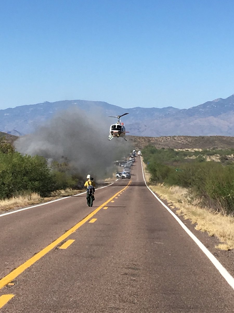
Several fire departments suppressed a fire, or possibly multiple fires, along Highway 83 approximately 60 air miles southeast of Tucson Wednesday.

The highway was completely closed for a while; later one lane was opened before the highway fully reopened after 10 p.m.

The fire reportedly burned about 146 acres.

wildfire barrel fire tucson
A helicopter assists firefighters along Highway 83 at the Barrel Fire southeast of Tucson May 16, 2018. Corona de Tucson FD photo.

Pinery Fire causes evacuation of Chiricahua National Monument in Arizona

Posted on Categories UncategorizedTags ,

Above: Map showing the location of the Pinery Fire in Southeast Arizona. The red dots represent heat detected by a satellite at 3:57 p.m. MDT May 11, 2018.

(Originally published at 8:17 p.m. MDT May 12, 2018)

A fire that started at 1:30 p.m. Saturday has forced the evacuation and closure of Chiricahua National Monument in Southeast Arizona. The cause is under investigation but it started on private land, moved onto the Chiricahua National Monument, and has since spread north onto the Coronado National Forest.

Our very unofficial estimate based on 3:57 p.m satellite data is that at that time it had burned approximately 400 acres. At 8 p.m. local time the National Park Service estimated the size at 675 acres.

Red Flag conditions on Saturday, including wind gusts up to 37 mph, are making containment difficult. The forecast for Sunday includes more Red Flag Warnings for the fire area with 86 degrees, 14 percent relative humidity, mostly sunny skies, and southwest winds of 13 to 25 mph with gusts up to 37 again.

The fire is under joint command of the Arizona Department of Forestry and Fire Management, the National Park Service, and the Coronado National Forest.

Multiple aircraft have been ordered, including 5 single engine air tankers, 4  large air tankers, and 3 helicopters. Seven engines, 2 initial attack crews, and 2 hotshot crews are working on the ground trying to stop forward progress. Additional resources have been ordered, including four more hotshot crews. The fire is 32 miles southeast of Willcox, 20 miles south of Interstate 10, 19 miles west of the Arizona/New Mexico border, and 44 miles north of the international border.
 

Viewpoint Fire burns thousands of acres north of Prescott Valley

Above: Map showing heat on the Viewpoint Fire detected by a satellite at 1:40 p.m MDT May 11, 2018.

(UPDATED at 7:40 a.m. MDT May 12, 2018)

Firefighters were able to get forward progress stopped on the Viewpoint Fire around 4:30 p.m MDT, Friday. The fire burned 5,100 acres before crews knocked down the fast moving fire that destroyed two homes and possibly three to four more in the Poquito Valley area. Between 10 and 12 other structures also burned. Once the area is deemed safe officials can get in to better assess the damages. More than 250 fire personnel, along with a very large air tanker and other aircraft, assisted in fire suppression efforts.

****

(UPDATED at 7:13 MDT May 11, 2018)

Arizona State Forestry reports forward progress on the Viewpoint Fire has stopped. They estimate it has burned 2,500 acres.

****
(Originally published at 4:01 p.m. MDT May 11, 2018. Updated at 6:42 p.m. MDT May 11, 2018)

A fire reported at 1 p.m. Friday has burned thousands of acres in Arizona a few miles north of Prescott Valley. Pushed by very strong winds, it was moving through an area with houses Friday afternoon six miles southeast of Chino Valley.

Our very unofficial estimate based on satellite data shows that it has burned at least 2,400 acres.

Mandatory evacuations were lifted in some areas, but are still in effect in others, according to Yavapai County Emergency Management.

Thanks and a tip of the hat go out to Tom.
Typos or errors, report them HERE.

OK Bar Fire in New Mexico is just about wrapped up

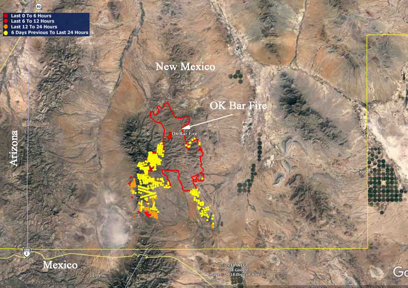
Above: Satellite photo taken May 6, 2018, showing the OK Bar Fire in Arizona.

Firefighters are just about finished with the OK Bar Fire in the southern panhandle of New Mexico three miles from the Mexican border. They made their “final” update on InciWeb May 4, writing:

The perimeter of the fire is secure, and firefighters are patrolling the perimeter and monitoring the fire by air. Due to aggressive fire management planning by the landowner and supporting non-profit organization, fire suppression actions have been designed to maximize firefighter safety and keep costs commensurate with the values at risk. Smoke and flames will continue to be visible on the mountain until significant moisture has been received on the fire.

The management strategy was not full suppression. Sunday’s National Situation Report shows 61,436 acres burned, an increase of 188 over the day before, and 5 engines assigned, for a total of 20 personnel.

OK Bar Fire Arizona
The red line was the perimeter of the OK Bar Fire as determined by infrared mapping at 2400 MDT May 3, 2018. The red, yellow, and brown dots represent heat detected by a satellite.

NASA satellite measures height of smoke column on Tinder Fire

Posted on Categories UncategorizedTags ,

Above, image credit:NASA/GSFC/LaRC/JPL-Caltech, MISR Team

I found out today that NASA has been measuring wildfire smoke plumes for at least a decade. The nine cameras on the Multi-angle Imaging SpectroRadiometer (MISR) have been capturing imagery of the Tinder Fire as it passes overhead on NASA’s Terra satellite. With a little trigonometry it can determine the height of smoke columns. The image above shows what it came up with after analyzing the fire on April 30, the day after it made its biggest run. Strong winds on both days probably kept the smoke from rising as high as it would have under calmer conditions.

(To see all articles on Wildfire Today about the Tinder Fire, click here.)

The two photos below were taken the day before the NASA analysis described here.

Tinder Fire
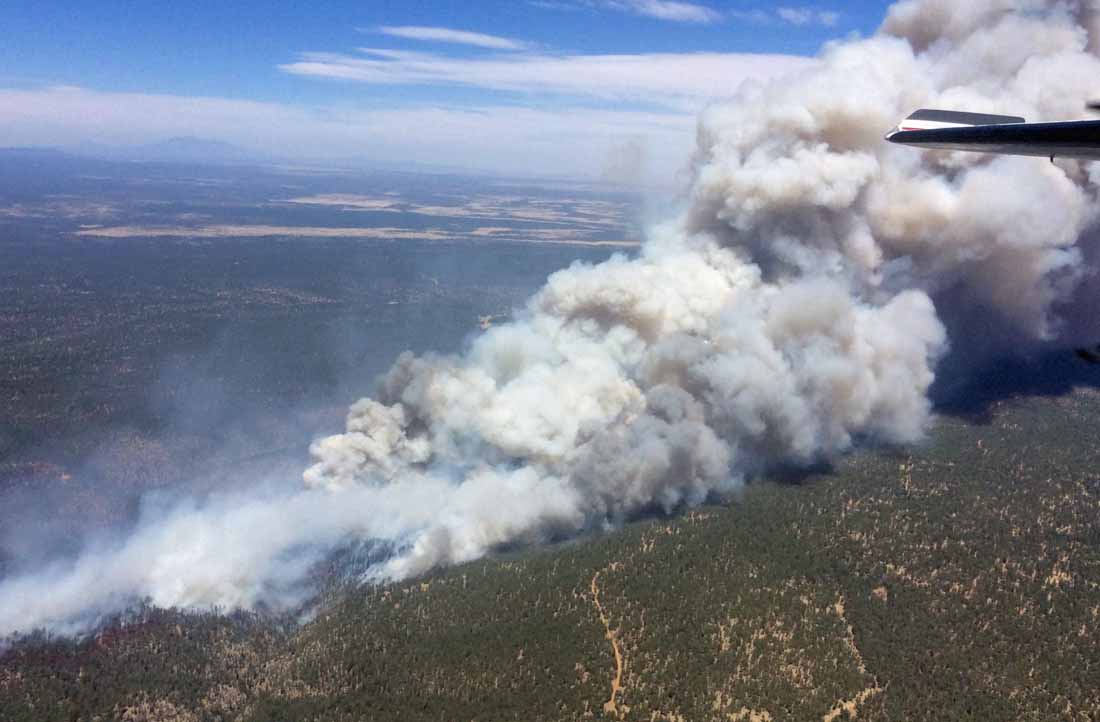
Tinder Fire, April 29, 2018. InciWeb photo, uncredited and undated.
Satellite photo Tinder Fire
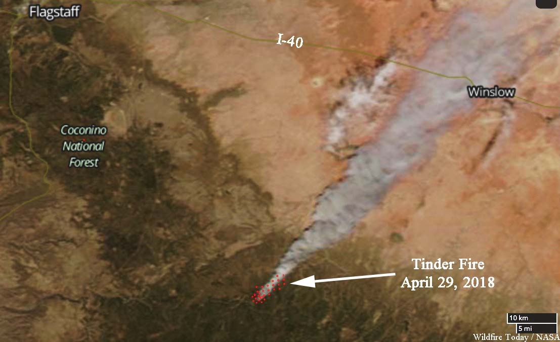
Satellite photo of the Tinder Fire, April 29, 2018. NASA.

Below is how NASA described the April 30 analysis:


“On April 30 at 11:15 a.m. local time, the Multi-angle Imaging SpectroRadiometer (MISR) captured imagery of the Tinder Fire as it passed overhead on NASA’s Terra satellite. The MISR instrument has nine cameras that view Earth at different angles. This image shows the view from MISR’s nadir (downward-pointing) camera. The angular information from MISR’s images is used to calculate the height of the smoke plume, results of which are superimposed on the right-hand image (Figure 1). This shows that the plume top near the active fire was at approximately 13,000 feet altitude (4,000 meters). In general, higher-altitude plumes transport smoke greater distances from the source, impacting communities downwind. A stereo anaglyph (Figure 2) providing a three-dimensional view of the plume is also shown. Red-blue glasses with the red lens placed over your left eye are required to observe the 3D effect.

“These data were acquired during Terra orbit 97691. The smoke plume height calculation was performed using the MISR INteractive eXplorer (MINX) software tool, which is publicly available at https://github.com/nasa/MINX. The MISR Plume Height Project maintains a database of global smoke plume heights, accessible at https://www-misr.jpl.nasa.gov/getData/accessData/MisrMinxPlumes2/.

“MISR was built and is managed by NASA’s Jet Propulsion Laboratory in Pasadena, California, for NASA’s Science Mission Directorate in Washington. The Terra spacecraft is managed by NASA’s Goddard Space Flight Center in Greenbelt, Maryland. The MISR data were obtained from the NASA Langley Research Center Atmospheric Science Data Center in Hampton, Virginia. JPL is a division of Caltech in Pasadena.”

Officials confirm 33 homes destroyed at the Tinder Fire

At least 54 outbuildings also burned, for a total of 87 structures

Above: Snow at the Tinder Fire Incident Command Post, May 2, 2018. IMT photo.

(Originally published at 1:55 p.m. MDT May 4, 2018)

The Incident Management Team reported Friday morning that 33 residences and 54 outbuildings burned in the Tinder Fire, which started a week ago 22 air miles northeast of Payson, Arizona.

(To see all articles on Wildfire Today about the Tinder Fire, click here.)

By sunset today, May 4, all evacuation orders will be lifted on the 12,628-acre blaze. Displaced residents are being allowed into the communities during a staged re-entry process beginning with those whose homes burned. Highway 87 will reopen at 7 p.m. today.

Firefighters are conducting burnout operations today on the northeast and east sides as conditions allow to further secure unburned interior islands within the fire perimeter.

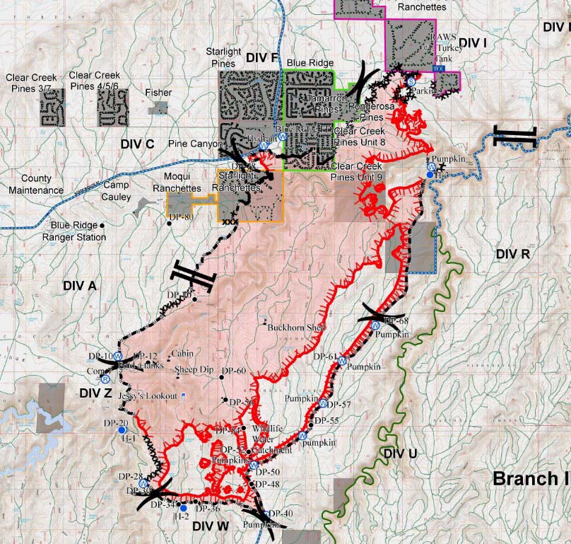
map Tinder Fire MAY 3, 2018
Incident Management Team map of the Tinder Fire May 3, 2018. The black lines represent areas where the fire is held by a road, dozer line, or hand-constructed fireline. The red lines are open fireline. Click here to see the original map with a legend.