3-D Map of the Crooks Fire, looking north. The red line was the perimeter at 3 a.m. MDT April 28, 2022. The white line was the perimeter two days before.
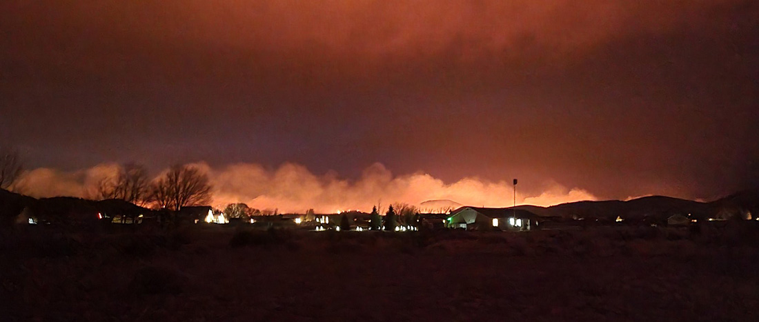
The northwest side of the Crooks Fire 8 miles south of Prescott, Arizona was very active Wednesday. In the last two days the section of the fire near Golden Eagle Road/Forest Road 97B has spread one mile to the west. Strong winds out of the south with 10 percent relative humidity contributed to the rapid spread. Wind gusts of 30 mph drove the fire west of Lookout Mountain toward Dosoris Canyon, pushing smoke into Prescott and surrounding communities. Crews were successful in holding the 52 Spur Road to keep the fire west of the affected communities. Most of the east side saw little or no movement Wednesday.
According to the Incident Management Team the fire has burned 9,014 acres.
Map of the Crooks Fire. The red line was the perimeter at 3 a.m. MDT April 28, 2022. The white line was the perimeter two days before.
On Thursday dozers and hand crews will work to strengthen the containment lines along Forest Service Road (FSR) 82. Favorable terrain may allow firefighters to access the fire’s edge west of Lookout Mountain, with the assistance of aircraft. Structure protection remains a key tactical objective and crews continue to perform defensive operations throughout the area.
Resources assigned as of Wednesday evening included 20 hand crews, 41 fire engines, and 14 helicopters for a total of 855 personnel.
The weather forecast for Thursday at 7,200 feet elevation calls for 21 mph gusting out of the south and southwest at 30 mph with relative humidity in the mid-teens. The elevation at the fire ranges from 5,000 to 7,000 feet. Friday the winds will decrease to 15 mph with 22 mph gusts from the west with 10 percent relative humidity.
Firefighters set up sprinklers to protect structures in the Mt. Tritle area. USFS photo, April 27, 2022.
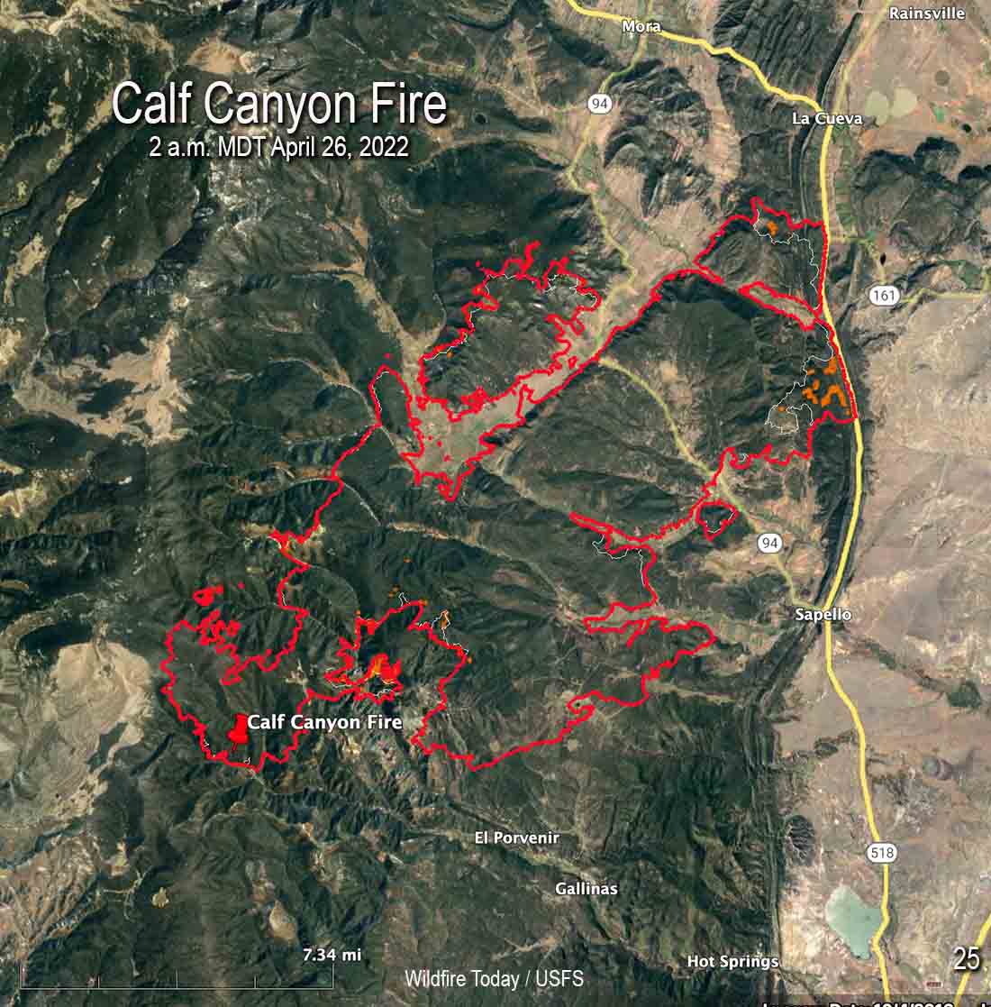
Map of the Calf Canyon Fire after it merged with the Hermits Peak Fire. The red line was the perimeter at 2 a.m. MDT April 26, 2022. The white line was the perimeter about 24 hours before.
With more favorable weather conditions and less active fire behavior on the Calf Canyon and Hermits Peak Fires, on Monday firefighters were able to engage in operations in areas that had previously been difficult to reach safely.
There was incremental growth on Monday. The fire was mapped by an aircraft at 2 a.m. MDT Tuesday and found to have burned 60,173 acres. That is the combined size of the two fires that merged.
Firefighters were able to engage aggressively across the fire area yesterday, capitalizing on the favorable weather conditions.
To see all articles on Wildfire Today about the Calf Canyon and Hermits Peak Fires, including the most recent, click HERE.
“Fire managers are determining where to focus resources based on weather, terrain, predicted fire behavior, and values at risk,” according to a statement issued by the Incident Management Team.”These decisions are based on the highest probability of success and flexible options in the event of sudden changes in weather or fire behavior.”
Law enforcement agencies are assessing impacts the fire had on structures and will be notifying property owners once confirmed.
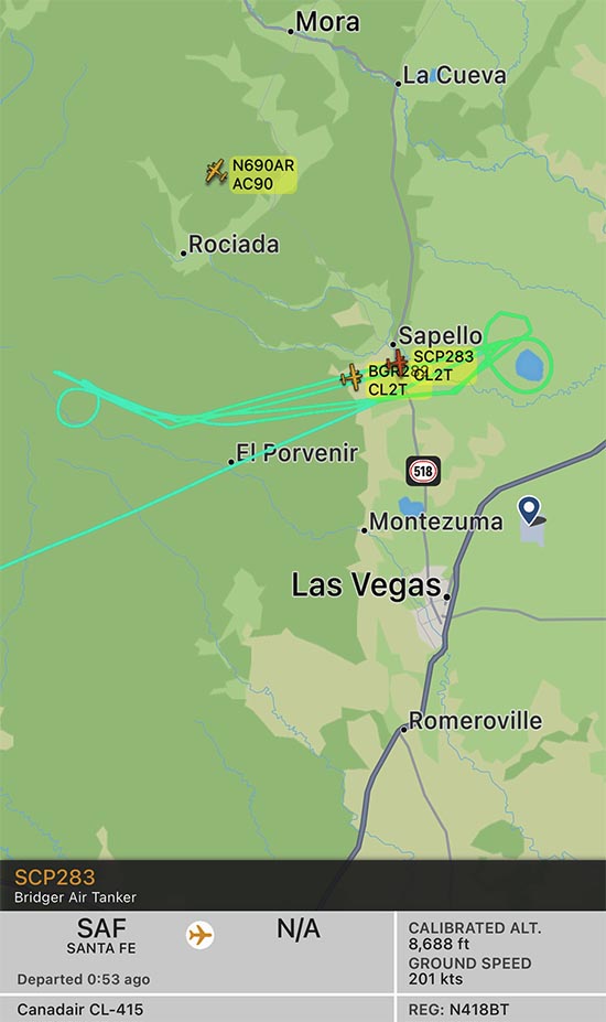
Map shwing two CL-415 air tankers on the Calf Canyon Fire, April 26, 2022. The track of one, Tanker 283, is displayed. FlightRadar24.
Beginning Monday and continuing on Tuesday, four water-scooping air tankers have been obtaining water from Lake Isabel and dropping it on the fire. To date, the scoopers along with other aircraft have delivered over 265,000 gallons. The lake is 8 miles east of the east side of the fire, which would be about a 5 minute one-way trip carrying up to 1,600 gallons of water. The map above shows the track of one of two CL-415 air tankers working the fire at 10:52 a.m. on Tuesday. An icon for a second CL-415 is also seen, but without its track — they often work in pairs.
Hermits Peak Fire by @jennalunaphoto
The wind will be out of the southwest at 20 mph Tuesday increasing to 24 with gusts to 32 on Wednesday. The forecast calls for the relative humidity to be in the high teens Tuesday, and on Wednesday in the 20s with a chance of thunderstorms and a small amount of rain.
The fire is eight miles south of Prescott, Arizona
4:38 p.m. MDT April 25, 2022
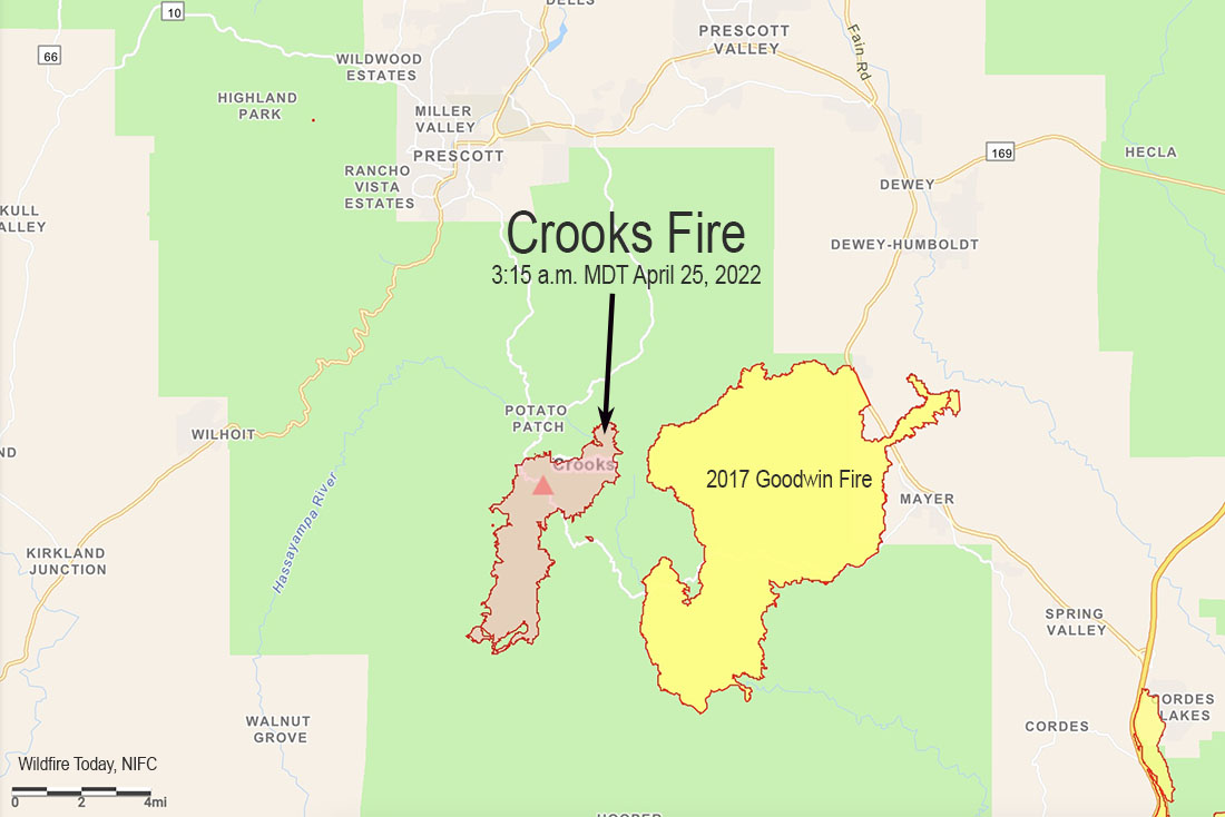
Crooks Fire map, 3:15 a.m. MDT April 25, 2022
A wind from the north on April 25 pushed the Crooks Fire three miles to the south in Ash Creek, increasing the size to 5,893 acres according to a fixed wing flight very early Monday morning. The northern edge of the blaze is 8 miles south of Prescott, Arizona. The east side is about a mile west of the Goodwin Fire that burned about 28,000 acres in 2017 (see map above).
The north wind provided good conditions Monday to complete firing operations on the north side to prevent spread to the northwest into Lookout Mountain and Dosoris Canyon. Throughout the day and into the night, firefighters extended the fireline south of Lookout Mountain toward Ash Creek and from Moscow Peak west to Senator Highway.
Crooks Fire as seen from Mt. Union Lookout, April 23, 2022. IMT photo.
Fire managers are planning contingency lines south and west of the fire in case winds push the fire in those directions.
Resources assigned include 19 hand crews, 38 fire engines, and 12 helicopters for a total of 675 personnel.
Weather
At 3:30 p.m. MST Monday at the Prescott Airport (elevation 5,043) the relative humidity was 9 percent, the temperature was 72, and the wind was east-southeast at 3 mph. The elevation at the fire ranges from 5,000 to 7,000 feet.
The weather on Tuesday and Wednesday could produce an increase in the rate of spread of the fire. The forecast for the area on Tuesday is for 20 mph winds out of the south gusting around 30, with relative humidity in the teens and the temperature in the 60s. On Wednesday the conditions will be similar but with winds a little stronger, 23 mph gusting to 26 mph. Thursday will be about the same as Wednesday.
Satellite photo showing smoke from the Crooks Fire at 3:01 p.m. MDT April 25, 2022.
Strong winds have spread the fire for 12 miles to the northeast
Updated 10:46 a.m. MDT April 21, 2022
From the staff at Sunset Crater Volcano National Monument, which was overrun by the Tunnel Fire.
“April 20
“All Sunset Crater Volcano and Wupatki staff are accounted for and safe. We were also able to successfully evacuate all culturally important items from the visitor center. For those who worried, the Kabotie painting, corn rock, Qa’na Katsina doll, and other items are safe.
“As of 4:45 this morning, the visitor center remains unharmed, as well. However, active fires continue to burn nearby. Sadly, Sunset Crater Volcano National Monument has burned in its entirety. The park is closed, and we do not have any estimated timeline for reopening.”
File photo of Sunset Crater Volcano National Monument, May 20, 2017.
In the map below, the Monument is inside the yellow border.
7:57 a.m. MDT April 21, 2022
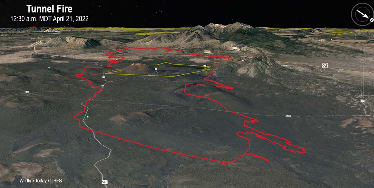
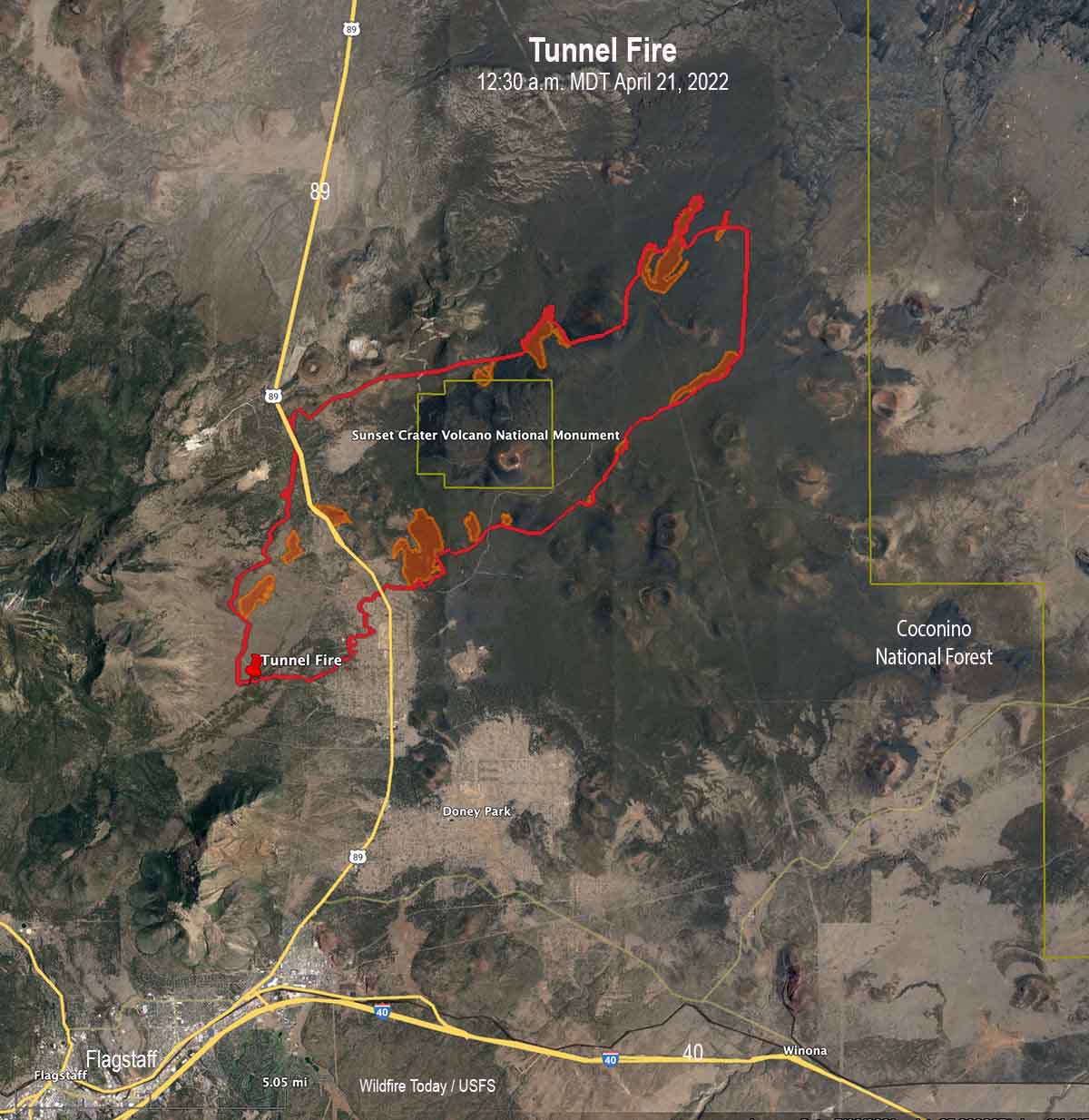
Map of the Tunnel Fire. Looking southwest at 12:30 a.m. MDT April 21, 2022.
The Tunnel Fire five miles north of the Flagstaff suburbs grew by about 3,000 acres Wednesday to bring the size up to more than 20,500 acres.
To see all articles on Wildfire Today about the Tunnel Fire, including the most recent, click here.
The fire started during the afternoon of April 17 west of Highway 89. Pushed by strong winds it spread rapidly to the northeast, crossed the highway, burned through Sunset Crater Volcano National Monument, crossed major electrical transmission lines, and early Thursday morning was about 10 miles east of Highway 89 approximately two miles from burning out of the Coconino National Forest.
Map of the Tunnel Fire at 12:30 a.m. MDT April 21, 2022. The brown shaded areas represent intense heat at the time the fire was mapped.
On Wednesday crews worked to keep the fire out of the Timberline Estates and Wupatki Trail subdivisions. They encountered natural gas leaking from foundations of burned structures, which slowed suppression activities. On Tuesday fire officials said 24 structures had burned. The number was not broken down by residences or outbuildings.
Strong winds on Wednesday again limited the ability of aircraft to safely and effectively support firefighters on the ground. Conditions are expected to become windier Thursday and Friday. A Red Flag Warning is in effect Thursday until 8 p.m. MST due to predicted gusts of 40 to 50 mph and 10 to 15 percent relative humidity.
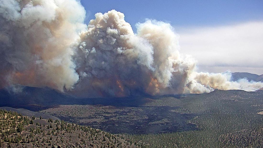
Tunnel Fire, April 19, 2022, as seen from O’Leary Lookout in Northern Arizona. USFS photo.
A National Type 1 Incident Management Team was ordered Tuesday. The 76 personnel with the team will begin arriving Thursday, with plans to assume command from the Type 3 IMT Friday morning.
Firefighting resources on scene include three dozers, 24 fire engines, and one Type 3 helicopter, for a total of 260 personnel.
U.S. Highway 89 is still closed from milepost 425 (Campbell Road) to milepost 445 and will likely remain closed for the next several days due to firefighting operations.
Information about evacuations, structures that have burned, and when people might be able to return is handled by Coconino County, which is posting updates online.
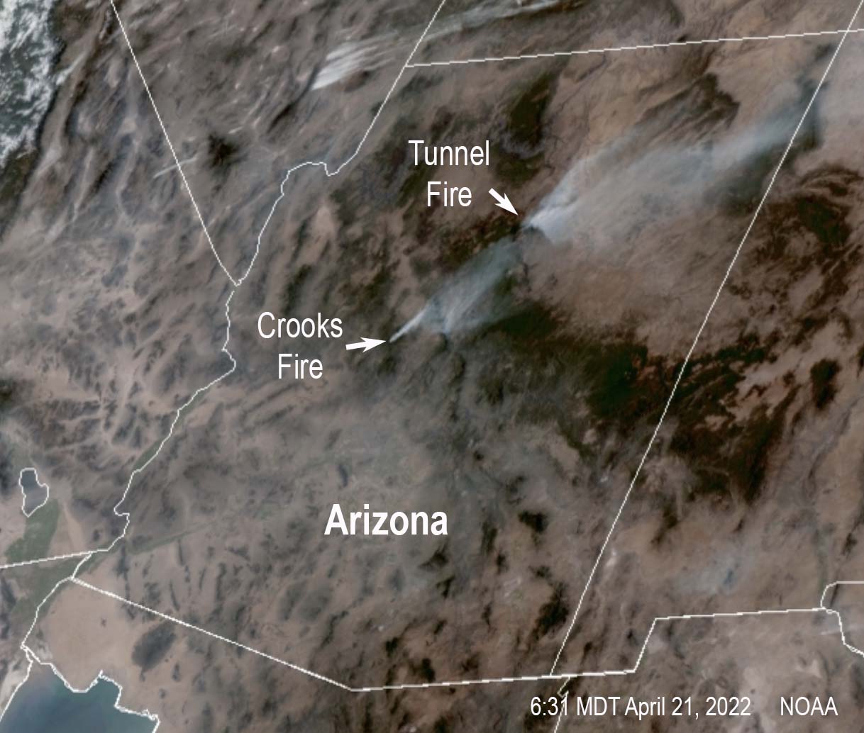
Satellite photo showing smoke from fires in Arizona, 6:31 p.m. MDT April 20, 2022.
A Type 1 Incident Management Team has been ordered
Updated 4:09 p.m. MDT April 20, 2022
The National Weather Service has issued a Red Flag Warning for northern Arizona from 11 a.m. until 8 p.m. MST, for 15 to 25 mph winds gusting to 35 and 11 percent relative humidity.
To see all articles about the Tunnel Fire on Wildfire Today, including the most recent, click here.
Here’s a look back at some of the meteorology yesterday that assisted in the rapid expansion of the #TunnelFire just east of Flagstaff on April 19th, 2022. #azwxpic.twitter.com/fyMzri4tdJ
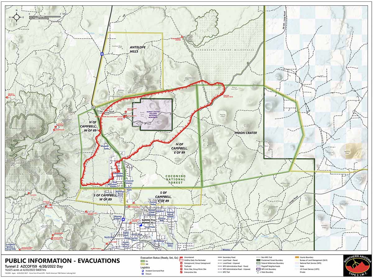
Map of the Tunnel Fire 4 a.m. April 20, 2022. The green line designates the “go”, evacuate now area. The yellow line is the “set”, be prepared to evacuate area.
The Tunnel Fire north of Flagstaff was mapped at approximately 16,625 acres at 4 a.m. Wednesday. The map above shows the go-now evacuation areas in green which affect about 750 homes.
Tuesday afternoon and night the fire burned through the Sunset Crater Volcano National Monument and kept going toward the northeast for another three to four miles. At 4 a.m. Wednesday it was about three miles from burning out of the Coconino National Forest.
The Arizona Department of Transportation reports that US Highway 89 is closed in both directions. There has been no update on the number of structures destroyed since Tuesday when it was announced that 24 had burned. The number was not broken down by residences or outbuildings.
Tunnel Fire, April 19, 2022.
The winds on Wednesday are predicted to be less extreme than on Tuesday. The National Weather Service forecast calls for 20 mph winds gusting out of the southwest at 25 mph, with 17 percent relative humidity under clear skies. The wind speeds will increase on Thursday, 23 mph gusting to 35, still out of the southwest and 18 percent relative humidity. Then on Friday the speeds increase to 29 mph gusting to 45 mph from the southwest, but with higher humidity — 30 percent — and a chance for 0.01 inch of rain Friday afternoon.
The Incident Management Team was apparently too busy Tuesday evening to submit the routine Incident Status Summary report, therefore limiting the amount of specific information available. A Type 1 IMT, Northwest Team 3 with Incident Commander Johnson, has been ordered.
10:13 p.m. MDT April 19, 2022
Map of the Tunnel Fire, 6:21 p.m. MDT April 19, 2022.
The Tunnel Fire four miles north of the Flagstaff suburbs was very active Tuesday afternoon, spreading across Highway 89 into Sunset Crater Volcano National Monument. Authorities with the Coconino National Forest estimated that by late in the afternoon on Tuesday it had grown to about 6,000 acres.
It was reported at 4:22 p.m. on Sunday April 17 (however some sources say it was on April 18). The cause is under investigation. Coconino County has the official evacuation information.
Tunnel Fire looking north from Lunar Dr. just south of Silver Saddle, April 19, 2022. Photo by Deborah Lee Soltesz.
Strong southwest winds that pushed the fire to the northeast are predicted to continue through Tuesday night at 30 mph gusting at 40 to 54 mph while the relative humidity remains below 30 percent. On Wednesday the winds will still be out of the southwest, but will decrease to 10 to 20 mph with gusts up to 30 mph while the relative humidity drops to 17 percent. With that forecast the fire will likely remain very active Tuesday night moving northeast.
The Forest Service said Tuesday night that 24 structures had burned.
Firefighting resources assigned include five handcrews, 15 engines, and three dozers. Air tankers were ordered Tuesday afternoon but had to be grounded due to very strong winds.
A Type 1 Incident Management Team has been ordered.
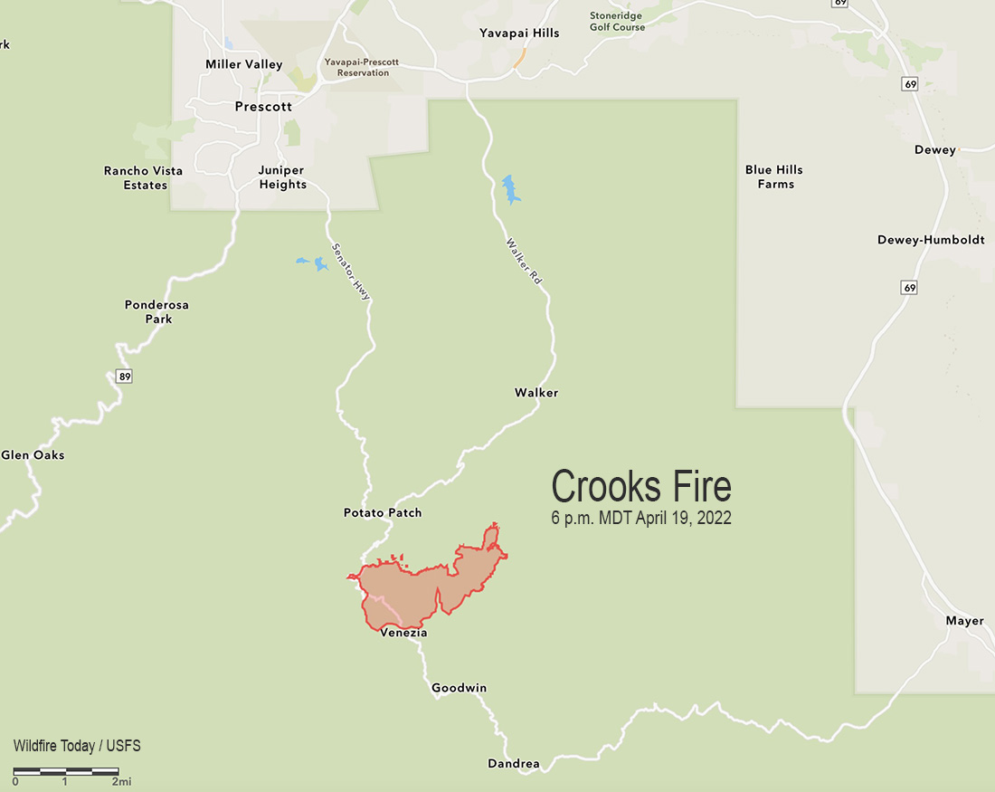
The Crooks Fire 8 miles south-southeast of Prescott, Arizona was 1,612 acres when it was mapped at 6 p.m. Tuesday. Most of the growth was toward the northeast as it burned south of Potato Patch and past Mt. Union as it approached Big Bug Mesa Road.
Red flag conditions in rugged terrain on Tuesday challenged firefighters and grounded aircraft through the day. Crews are looking for opportunities to construct indirect line hoping to keep the fire south of FSR 261 road and restrict its spread to the north.
A Type 1 Incident Management Team, California IMT 4, will assume command of the fire Wednesday at 6 p.m.
Resources assigned include 7 hand crews, 14 fire engines, and 5 helicopters for a total of 292 personnel.
Information about evacuations can be found at the Yavapai County Sheriff’s Department Facebook page.
1:16 p.m. MDT April 19, 2022
Map of the Crooks Fire showing heat detected by satellites at 2:39 a.m. MDT April 19, 2022.
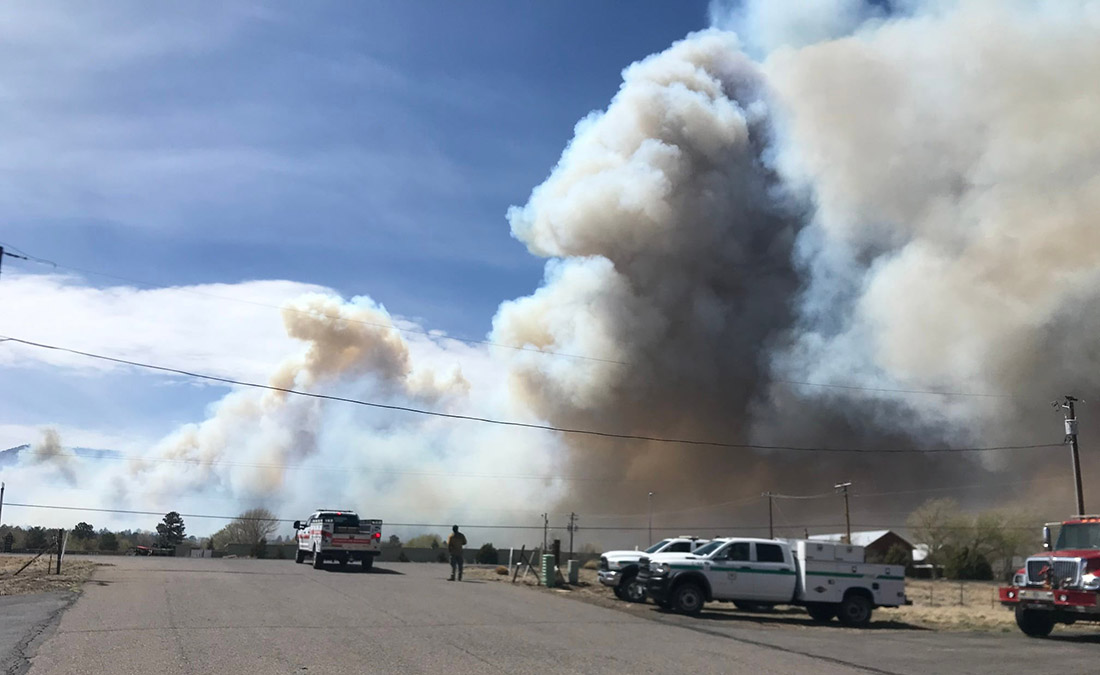
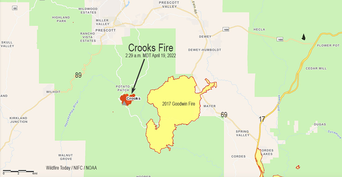
A new fire, the Crooks Fire, broke out Monday eight miles south of Prescott, Arizona. Fire authorities said Tuesday the fire had burned 600 acres in the Prescott National Forest.
The fire is about two miles west of the Goodwin Fire that burned more than 28,000 acres in 2017.
The area is under a Red Flag Warning until 8 p.m. MDT Tuesday for 25 to 35 mph winds gusting out of the southwest at up to 50 mph with relative humidity around 10 percent.
Information from the Incident Management organization late Tuesday morning:
Ryan Barela’s Arizona Central West Zone Type 3 Incident Management will assume command of the Crooks Fire [Tuesday] at 6:00 PM. The fire remained active last night as crews worked through the night on structure protection and burning fuels along Forest Road (FR) 261 and along Senator Highway. Firefighters will focus today on keeping the fire south of FR 261 and east of Senator Highway. Fires in Prescott, AZ typically are driven by southwestern winds that push the fire to the northeast, therefore, we are prioritizing working on the northeastern part of the fire.
The Southwest Area Coordination Center said Tuesday afternoon that a Type 1 Incident Management Team from California, led by Incident Commander Gamboa, has been ordered.
(This article was corrected at 1:53 p.m. MDT Tuesday April 19 to correct conflation with the Crooks Peak Fire which is also in the Southwest Geographic Area.)