Record heat in northern and southern hemisphere

If you are one of the 18 remaining climate change deniers, you should stop reading now, because what follows will make you uncomfortable.

Northern Hemisphere:
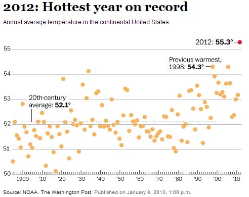
Average temperatures, United StatesThe National Oceanic and Atmospheric Administration (NOAA) is reporting that last year was the hottest on record for the contiguous United States, shattering CRUSHING by a wide margin the previous record set in 1998. The average temperature of 55.3 degrees Fahrenheit was 1 degree above the previous record and 3.2 degrees higher than the average for the 20th century. That is a huge difference.

From the Washington Post:

Last year’s record temperature is “clearly symptomatic of a changing climate,” said Thomas R. Karl, who directs NOAA’s National Climatic Data Center. Americans can now see the sustained warmth over the course of their own lifetimes — “something we haven’t seen before.” He added, “That doesn’t mean every season and every year is going to be breaking all-time records, but you’re going to see this with increasing frequency.”

Southern Hemisphere:

Extremely high record-breaking temperatures and “catastrophic” fire danger ratings in Australia are not only contributing to the rapid spread of numerous bush fires, but they may cause some electronic gadgets to stop working. According to Wired, Apple advises that an iPhone should not be used when temperatures reach 95F (35C). In Sydney yesterday the high was 108F (42C).

The extreme weather is also causing problems for meteorologists when they attempt to display the highest ever recorded temperatures on their standard maps.

From Wired:

Australia’s Bureau of Meteorology had to add new colors to its weather map. Now, those unfortunate parts of Australia that achieve temperatures above 122ºF (50ºC) — temperatures that were, until recently, literally off the scale — will be marked in deep purple and terrifying hot pink. It is an interesting moment in data visualization history when climate scientists find themselves in the position of revising the upper bounds of temperatures they ever expected to depict.

It is possible that our electronics and our infrastructure were designed for a climate that we no longer have. When the streets and buildings of lower Manhattan were built, no one expected that they would be flooded by a hurricane. Apple did not design the iPhone for the recent weather in Australia.


Thanks go out to Clyde, Kelly, and Dick

Unmanned aerial vehicles considered for monitoring fires in Australia

With numerous large fires burning in Australia, there has been discussion about the practicality of using unmanned aerial vehicles (UAV) to detect and monitor fires. In an article at Wired, Thomas Duff of the University of Melbourne’s Bushfire Cooperative Research Centre, which developed the Phoenix RapidFire bushfire simulator said he believes…

…the vast amount of data gathered by drones could be sent to base via data links and potentially provide far more accurate, real-time predictions of where a fire will spread and when.

NASA is already using drones to study hurricane patterns as part of its Global Hawk project, and it would be no great leap to do the same thing in Australia.

“From an aircraft point of view and a sensing point of view the technology is there,” said Duncan Campbell, head of the Australian Research Centre for Aerospace Automation. Campbell is currently working on embedding drones with smart sensors that prevent them from colliding with aircraft. “The big issue is the use of the airspace and that comes down to regulatory issues.” Nevertheless, he predicts we’ll see them in action over Australian skies within two years. However, we won’t be seeing pricey military grade versions:

“What we’re more likely to see in Australia are the smaller machines in the order of a few 100kg, flying a lot lower.”

The last time we wrote about Australia’s desire to buy large drones was in March, 2009, when they cancelled plans to buy some Global Hawks with an announced objective being surveillance of the waters surrounding the country. Since then the government has gone back and forth several times on buying or not buying these aircraft. The latest, according to Australia’s ABC News in September, 2012, is that the the military wants seven large UAVs flying by 2019. The preferred option is a new, maritime surveillance version of the Global Hawk – the MQ4C Triton with a total cost of $2 billion to $3 billion.


Thanks go out to Dick

Videos, Australia’s bush fires

Australia is currently experiencing record heat and numerous bush fires. This first video is a must see. It describes how a family fled their Dunalley, Tasmania home as a rapidly spreading fire approached, and took refuge in the ocean or a lake (I’m not sure which). Some of them remained submerged up to their chest for three hours while they waited for conditions to moderate. The video is about 10 minutes long, but worth it.

This next video was uploaded Monday, January 7 (Australia time), and describes the “catastrophic” fire danger that is predicted for Tuesday. It could be the most extreme bush fire burning conditions in decades for Australia, and features an interview with Rob Rogers, Deputy Commissioner of the New South Wales Rural Fire Service.

And last, the Premier of Tasmania, Laura Giddings, and Prime Minister Julia Gillard speak about the fires. The Prime Minister mentions the “great mate ship” with the people of Tasmania.


Australian firefighter burned

The New South Wales Rural Fire Service in Australia is reporting that a male firefighter sustained severe burns to his hands and face while fighting a grass fire at Gundaroo, New South Wales, southeast of Yass Monday afternoon. He was airlifted to the Burns Unit at Concord Hospital.

ABC News in Australia reports the firefighter is in stable condition after suffering burns to five percent of his body. The firefighter was one of the first on the scene and was injured when his truck was engulfed in the fast moving fire front. The truck was heavily damaged.

Authorities in Australia recommend evacuation due to “catastrophic” fire danger

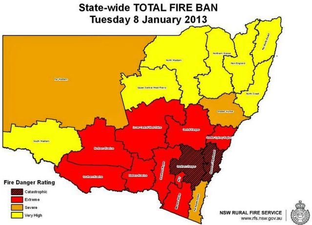
NSW fire danger January 8, 2013
New South Wales fire danger predicted for January 8, 2013

As we write this at about 11 a.m. Mountain Time in the United States, the sun will be rising in an hour Tuesday morning in New South Wales, Australia. Residents there will experience a day that could have the most extreme fire danger ever recorded. Predictions in the state for Tuesday range from Very High to Catastrophic.

Australia’s ABC News reports that Rural Fire Service (RFS) Commissioner Shane Fitzsimmons said:

Catastrophic fire danger ratings are the worst you can get. We are talking about the most extreme fire behaviour – destruction is likely. We will see ember showers likely to be thrown 10 kilometres, if not 20 kilometres ahead, under the extraordinary conditions being forecast. We are looking at widespread areas of New South Wales likely to experience very high, severe, and even catastrophic conditions.

We’ve got 91 different fires … there’s a lot of work with firefighters on the ground at the moment – more than 650 firefighters working across those fire grounds, looking to bring those fires under control as much as possible.

About 20 of those 91 fires are not under control.

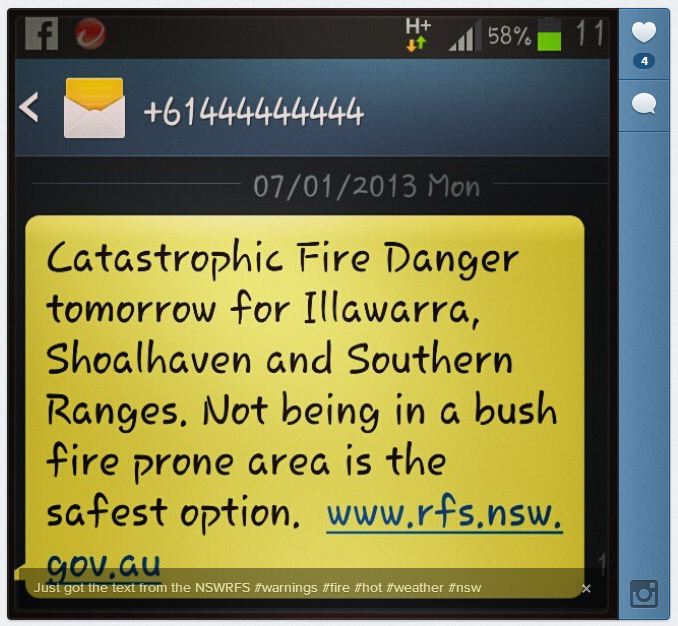
Here is the text of an emergency alert telephone message, a SMS, that was sent to the Illawarra, Shoalhaven, and Southern Ranges regions Monday night ahead of a 43C (109F) temperature forecast, recommending people escape while they can.

If you have received this message you are in an area that is forecast to have Catastrophic Fire Danger on Tuesday 8 January 2013.

For your survival, leaving early is the safest option. Leaving a bush fire prone area tonight or early tomorrow morning is recommended.

Make a decision about when you will leave, where you will go and how you will get there. Homes are not designed to withstand fires in catastrophic conditions.

Below is a screen capture from a cell phone of another similar message sent out by the RFS on Monday, January 7:

NSW RFS fire danger warning
Matt_1110 posted to Instagram this screen capture from his cell phone with a slightly different message, also from the RFS.

In my experience, this is unprecedented, at least in the United States, recommending that residents evacuate based on predicted fire danger — an example of proactive, forward-leaning leadership. If large, damaging fires erupt, the leaders will be praised as heroes. If not, there may be criticism.

The Premier, Barry O’Farrel, is also getting involved, and was quoted at ABC News as saying:

[It] is not going to be just another ordinary day. [It could] be perhaps the worst fire danger day this state has ever faced. If Sydney reaches 43C [109F] [Tuesday], it will only be the third time in the history of record keeping that the temperature in Sydney has been that high.

Last month we wrote an article at Fire Aviation which detailed the aviation resources that were going to be available in Victoria this 2012-2013 fire season down under. Last year they leased two CV-580 air tankers from Conair, but this year it appears there are no large air tankers in Victoria. UPDATE: The Australian states and territories each operate or contract for their own firefighting aircraft, but they are shared across lines as needed. This fire season among all the states there are no large air tankers, but they have 14 small single engine air tankers and 35 helicopters which are used for various purposes.

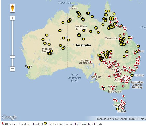
Current fires in Australia


Thanks go out to Dick and Kelly.

One hundred missing after fires in Tasmania

Map of Inala Road fire, Tasmania
Map of Inala Road fire (shown in brown), east of Hobart, Tasmania. Updated at 1:07 a.m. local time, January 7, 2013

Police in Tasmania are attempting to locate up to 100 people that are still unaccounted for in areas that have burned in the bushfires on the island south of Australia. The largest, the Inala Road Fire, is burning about 32 Kilometers (20 miles) east of Hobart on the Tasman Peninsula and in or near the communities ofTaranna, Lewisham,Dunalley, Copping, Forcett, Connellys Marsh, Dodges Ferry, Eaglehawk Neck, Primrose Sands,Murdunna,Boomers Bay,Bream Creek and Sommers Bay.

Many tourists were stranded on the Tasman Peninsula, unable to return home due to closed roads. Commercial and private vessels transported about 2,500 of them back to the mainland while an estimated 2,000 are being housed at the Nubeena Refuge Centre, about 600 at Port Arthur and another 100 at the Dunalley Hotel.

Approximately 100 structures have burned in the fires which are still burning out of control. No deaths have been confirmed, but Tasmania Police are conducting house to house searches.

The Inala Road fire has burned 19,214 hectares (47,478 acres). The Dawson Road Lake Repulse fire, about 48 kilometers (30 miles) northwest of Hobart, has blackened 9,895 hectares (24,451 acres). Firefighters from other Australian states have been arriving to help fight four fires have burned a total of about 60,000 hectares (148,000 acres).

Wikipedia-style fire update for Inala Road Fire
Wikipedia-style (but analog) fire update for Inala Road Fire. Photo by j_fosk

Warwick Hughes contacted us to let us know he has been writing about the fires on his web site. He posted a link showing a recording of smoke showing up in weather radar (screen capture is below), as well as some weather data recorded in the community of Dunalley where many homes burned. The weather station showed a high temperature of 54.9C (131F) at 4:22 p.m. on January 4, which was undoubtedly affected by heat from the fire.

Smoke from Tasmania fires, detected by weather radar
Smoke from Tasmania fires, detected by weather radar.


Thanks go out to Dick, Kelly, and Warwick.