The British Columbia Wildfire Service released this information late Sunday night, July 5, 2015:
We sign off with heavy hearts tonight. We were saddened to learn that a contract tree faller working with us on the Old Sechelt Mine fire suffered a fatal injury while felling a danger tree earlier today. Our thoughts and prayers go out to his friends, family and co-workers.
This is a tragic reminder of the dangerous work being done by personnel across the province to respond to wildfires.
Our sincere condolences go out to the family, friends, and co-workers.
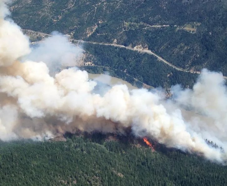
The Old Sechelt Mine Fire has burned 80 hectares (198 acres) since it was discovered July 2 two km northwest of Sechelt.
UPDATE at 7:30 p.m. MT, July 6, 2015: Kelowna Now reports that the coroner has identified the faller as John Joe Phare, age 60, from Roberts Creek.
Cisco Road Fire, June 11, 2015. Photo by B.C. Wildfire Management Branch.
The British Columbia Wildfire Management Branch says the Cisco Road Fire south of Lytton, B.C. has been mapped at 1,500 hectares (3,700 acres). The size will increase as the fire crews conduct strategic burning operations.
Cisco Road Fire, June 11, 2015. Photo by B.C. Wildfire Management Branch.
Firefighters will be watching for high winds today — predicted to be southerly for most of Friday morning, with the chance of a shift to northerly later in the afternoon. Crews did experience a trace amount of precipitation on some areas of the fire Friday morning.
****
Cisco Road Fire south of Lytton, BC at 3:22 pm PT June 11, 2015.
(UPDATE at 5:29 p.m. PT, June 11, 2015)
The British Columbia Wildfire Management Branch said at 2:58 PT that the new wildfire, now named Cisco Road Fire, west of the Fraser River south of Lytton (map) has burned about 600 hectares (1,482 acres) and is zero percent contained:
This fire is displaying aggressive fire behaviour (Rank 5) and is located in difficult terrain [Rank 5 fire behaviour is a crown fire that has the potential for short-range spotting] . Winds 40 gusting 60 km/hr [25 mph gusting to 37 mph] from the south are continuing to challenge suppression efforts. There are currently 22 firefighters on site, with 20 more en route. Three helicopters are providing bucking support for ground crews.
An Evacuation Alert and Order have been issued by the Lytton First Nations Band for nearby First Nations communities.
I wonder about the future of the live cam that is getting these great photos? If the wind shifts to come out of the north, it will probably be toast, unless it can be evacuated, or unless it has sufficient clearance around it. I think the cam is looking north, and that jives with the south wind described above..
****
(Originally published at 2:32 p.m. PT, June 11, 2015)
An image grabbed from a live web cam of a fire south of Lytton, B.C. at 3:22 p.m. MT, June 11, 2015.
A new wildfire south of Lytton, B.C. has gotten a running start up a steep slope, as you can see in the photo that was captured by a live camera operated by Lyttonnet. Not much information is available yet, but CBC News reported at 1:57 p.m. PT that it was 150 hectares (370 acres) on the west side of the Fraser River. The B.C. Wildfire Management Branch says the fire was reported around noon and is threatening structures near Lytton, roughly 100 kilometers north of Hope.
The British Columbia government has a very interesting website that provides a forecast for wildfire smoke. The image above is for Monday, June 1, and the one below is for Wednesday, June 3.
Wildfire smoke forecast for Canada on June 3.
To see the most current smoke reports on Wildfire Today, visit the articles tagged “smoke” at https://wildfiretoday.com/tag/smoke/
The Little Bobtail Lake Fire. Photo provided by the British Columbia Wildfire Management Branch, May 15, 2015. (click to enlarge)
We don’t usually put too much confidence in the containment percentages government personnel assign to wildfires, since sometimes it is extremely subjective and not always based on reality, but as the Little Bobtail Fire southwest of Prince George, British Columbia continues to grow, the containment percentage decreased today from 20 percent to 15 percent. The blaze has now blackened 25,000 hectares, or 62,000 acres.
Our main site for the Little Bobtail Lake Fire is HERE, with much more detail.
The Little Bobtail Lake Fire. Photo provided by the British Columbia Wildfire Management Branch, May 15, 2015.
We don’t usually put too much confidence in the containment percentages government personnel assign to wildfires, since sometimes it is extremely subjective and not always based on reality, but as the Little Bobtail Lake Fire southwest of Prince George, British Columbia continues to grow, the containment percentage decreased today from 20 percent to 15 percent. The blaze has now blackened 25,000 hectares, or 62,000 acres.
Winds Tuesday afternoon could include gusts up to 40 km per hour. After a small amount of rain on portions of the fire on Monday, a drying trend is in the forecast.
Resources working the fire include 315 firefighters, 12 helicopters, 32 heavy equipment, and 8 air tankers.
(UPDATED at 2:10 p.m. MDT, May 17, 2015)
Little Bobtail Lake Fire. Branch of Wildland Fire photo.
Due to strong winds with gusts of up to 35 km/hr, fire activity increased on the Little Bobtail Lake wildfire on Saturday. Growth was experienced along the northwest, southwest, and southeast flanks. Aircraft are supporting ground crews in trying to gain control of this most recent activity. The fire is moving away from the Cluculz Lake and HWY 16 area.
The fire has burned an estimated 24,000 hectares (59,000 acres). Satellite photos showed a very large plume of smoke being transported to the southwest.
****
(UPDATED at 9:10 p.m. MDT, May 15, 2015)
Little Bobtail Lake Fire. Photo credit: BC Wildfire Management Branch.
The Little Bobtail Lake Fire southwest of Prince George, B.C. has now burned 17,000 hectares (42,000 acres). Yesterday it was mapped at 13,000 hectares (32,000 acres). There are 190 personnel now, and 60 more will be added today.
There are also 8 helicopters, 8 air tankers, and 22 pieces of heavy equipment working the fire. Some of the helicopters are bucketing and others are serving as administrative air support. There is a total of six Air Tractor 802 scooping air tankers as well as two Electra airtankers working to cool down fire activity on several flanks of the fire.
****
(UPDATED at 8:40 p.m. MDT, May 14, 2015)
Little Bobtail Lake Fire. Photo provided by BC Wildfire Management Branch. (click to enlarge)
The Wildfire Management Branch reported at 1 p.m. today that the Little Bobtail Lake Fire 25 miles southwest of Prince George is growing rapidly and has burned 13,000 hectares (32,000 acres). Yesterday it was mapped at 8,000 hectares (19,700 acres) and had tripled in size in the previous two days.
Not much additional information is available, except for the map below, and the list of firefighting resources working the fire: 170 firefighters, 8 helicopters, 10 heavy equipment, and 4 airtankers.
Little Bobtail Lake Fire map May 14, 2015. NASA image. The red dots represent heat detected by a satellite on May 14, 2015. (click to enlarge)
According to a summary of the 2014 wildfire season in Canada prepared by Environment Canada, the number of acres burned in the country was three times the 20-year average, due primarily to heavy fire activity in the Northwest Territories and British Columbia.
Here is how they summed it up:
****
“While conditions were not favourable for wildfires in most areas of the country in 2014, it was still a huge wildfire year in Canada. According to the Canadian Interagency Forest Fire Centre, although the absolute number of wildland fires was 10 per cent less than the 20-year average, the area burned was three times higher than the 20-year national average (4.6 million hectares vs. the normal 1.5 million hectares). So even with parts of Canada being, at times, soaked by heavy rains or underwater from floods, the Northwest Territories and British Columbia made up for it all with exceptional warmth and dryness that brought sparks to infernos in no time flat.
In the Northwest Territories it started with a cold winter and scanty snows that left the ground and forest litter dry. With summer came clear skies and record warm temperatures that optimized already perfect conditions for fires to spread. The principal culprit was a stalled ridge of drying air anchored over the Mackenzie River valley for weeks. Temperatures from Tuktoyaktuk to Yellowknife averaged well above historic averages. The Mackenzie region averaged 1.6°C warmer than normal – the seventh warmest summer in 67 years. Yellowknife had 22 days in June and July at or above 25°C, compared to an average of eight, and only two days in June and three in July with rain. In a 91-day span, from the May long-weekend onwards, Yellowknife received only one-half its normal rainfall. As further evidence of the dryness, water levels in the Mackenzie River dropped to some of the lowest seen in more than 30 years.
So it was no surprise to anyone that the Northwest Territories had its worst fire season in 30 years with nearly 3.4 million hectares razed. That’s seven times the normal acreage consumed and six times the size of Prince Edward Island. At the peak of the fire season, smoke, ash and moisture from intense fires travelled as high as 15 km in the air, easily circling the globe. Some plumes travelled south and east affecting air quality in the northern plains of the United States, the Canadian Maritimes and even as far as Portugal. The fires caused a host of problems, including highway closures due to reduced visibility, the destruction of fibre optic cables and the interruption of Yellowknife’s main power supply line.
Health risks were also a concern as the city’s hospital treated twice the usual number of patients for respiratory and allergy issues. Smoke was so thick that, at times, it was hard to breathe indoors with the windows closed let alone venturing outside. Widespread forest fires also stranded visitors and adversely affected busy tourist camps and attractions. In August, firefighters and residents finally got a breather when cooler and wetter weather took hold. Temperatures dropped significantly and rainfall was 50 per cent more than normal for the month.
In British Columbia, an overheated wildfire season scorched the third-biggest loss of timber in the province since authorities began recording wildfire statistics more than 60 years ago. Fires burned more than 338,000 hectares through the province – seven and a half times the normal area charred on average over 20 years. No homes or notable structures were destroyed, but the province more than quadrupled its firefighting budget, spending $266 million.
Conditions for the wildfire season started in 2013 when places like Victoria experienced their driest October-to-December on record. Summer perfected conditions for igniting and spreading wildfires as average temperature across coastal and southern portions of the province made for the third-warmest summer over 67 years of record-keeping and one of the top ten driest summers. Record-high July maximum temperatures soared into the low 40s in several interior communities. Some places claimed it was the driest summer in more than half a century. Among the major fires were those that burned in vast dead pine forests killed by mountain pine beetles or on steep, inaccessible terrain, increasing risks and challenges to firefighters and communities.
Nearly 400 firefighters from Ontario, the Maritimes, Alaska and even Australia pitched in to help. The biggest and most difficult forest fire was near the Chelaslie River south of Burns Lake in northwestern British Columbia. It burned 133,162 hectares, accounting for more than 30 per cent of land burned in the province this year. Another big fire occurred in northern British Columbia near the Alberta border when a lightning strike whipped by strong winds caused 3,800 hectares to burn at Red Deer Creek. And a fire at Smith Creek, west of Kelowna, forced 2,500 people out of their homes. Over the course of the summer a series of smoke advisories and special air quality statements, issued by the province and Environment Canada respectively, were put in place for many regions, including the Okanagan Valley where residents of Peachland were urged to keep small children, the elderly and pets inside. On occasion, even Vancouver and the Fraser Valley were subject to air quality advisories as smoke plumes hung heavy over the skies.
Fortunately, timely rains and cool temperatures from September through October saved British Columbia from a second disastrous forest fire season and brought much-needed moisture to the somewhat water-starved province. Rainfall in Victoria and Vancouver totalled more than 40 per cent above normal, with Vancouver experiencing its wettest September-October in 10 years.”
****
An interpretive sign in Alberta’s Bow Valley. Photo by Bill Gabbert.
(To see a high resolution 3.8MB version of the above photo, click HERE.)