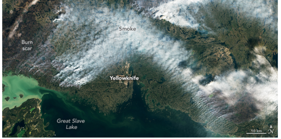
Hundreds of wildfires burning in Canada’s Northwest Territories have resulted in emergency declarations and the evacuation of the capital city of Yellowknife — by road and by air. About 20,000 residents of Yellowknife have been ordered to leave, as more than 230 fires burn across the territory and smoke drifts south into the United States. CNN reported that Yellowknife accounts for about half of the total population of the remote territory, located north of Alberta and east of Yukon.
The BBC reported that thousands of people on the outskirts of Yellowknife, one of the largest cities in Canada’s north, have crowded into the local airport and choked the road out of town. Hundreds have lined up for emergency military evacuation flights, and officials have given Yellowknife residents a deadline of noon Friday to leave.
NASA image of NWT smoke August 16, 2023
“We’re all tired of the word unprecedented,” said Premier Caroline Cochrane.
This afternoon the fire had burned to within 16km (10 miles) of the city. “Very tough days ahead,” said the territorial fire service, predicting more high winds. The closest evacuation shelter is 1,100km south of Yellowknife.
Military evacuation flights were scheduled today, with five flights to Calgary in the neighboring province of Alberta. The federal transport minister said Air Canada is capping the cost of flights out of Yellowknife and has added two extra flights out of the city.
One of the fires west of Yellowknife is at 165,000 hectares — over 407,000 acres. “We’re all tired of the word unprecedented,” said Premier Caroline Cochrane. “Yet there is no other way to describe this situation in the Northwest Territories.”
Another firefighter has been killed during Canada’s worst wildfire season on record.
The firefighter from Fort Liard, a hamlet in the southwest corner of the Northwest Territories, died of an injury he sustained while fighting a fire in the Fort Liard district on Saturday. The globalnews.ca reported that the Government of the Northwest Territories did not identify the firefighter, but confirmed that his family, the RCMP, and the Coroner Service were notified.
The Journal of Commerce reported that Fort Liard Mayor Genevieve McLeod said word began circulating in the community late Saturday afternoon that there had been an accident. At first, it was only thought that someone had been hurt, and there was no word who it was.
“A big part of the community went to the airport to meet the helicopter,” McLeod said in a phone interview. “They brought the individuals in from the forest fire they were fighting and that’s when everyone found out.”
McLeod, too, didn’t want to identify the firefighter who died, noting he had a large family and that some, who lived in the south, might not have yet heard the devastating news.
“He was a big part of our community — young and hard working. He has a young family,” she said.
“Our thoughts are with his family, friends, colleagues and community,” wrote fire information officer Jessica Davey-Quantick. “We share your deep sorrow at this loss, and we send our deepest condolences to all those affected by this tragedy, including wildfire personnel who are committed to protecting their communities and the residents of the NWT.” There are at least three wildfires burning near Fort Liard, about 37 kilometres (23 miles) north of the B.C. border.
On Sunday NWT Premier Caroline Cochrane said she was deeply saddened by the loss of life sustained while protecting the territory, and she thanked the man for his service. “This is a tragic loss for the entire territory, and I extend my heartfelt condolences to their family, friends and colleagues.”
As of yesterday, according to the ctvnews.ca, the danger level was considered “extreme” for fires in the Fort Liard area. Currently, there are 89 active fires burning across the Northwest Territories, including one new fire that started in the last 24 hours. More than 809,000 hectares are affected by the fires in that territory.
UPDATE 07/20/2023: WILDLAND FIREFIGHTER Magazine reported that Firefighter Adam Yeadon, 25, from Fort Liard was a member of the Acho Dene Koe band.
Conditions in June and July are expected to be well above average.
Forecasts are showing that fire weather severity in the western provinces of Canada will be increasing in May, and by June will be in the Extreme category in large areas of British Columbia, Alberta, Saskatchewan, and Northwest Territories.
Conditions in June and July are expected to be well above average, according to data from the Canadian Wildland Fire Information System provided by the Canadian Meteorological Centre, a branch of Environment Canada.
President Trump offered assistance to Russia with their wildfires in the Siberian arctic
Map showing the location of the Inuvik Fire in Northwest Canada, according to satellite data collected at 10:49 a.m. MDT August 1, 2019.
A wildfire in Canada’s Northwest Territories arctic has burned about 45,000 hectares (112,000 acres) according to the last size estimate by the Northwest Territories Environment and Natural Resources agency. Our very unofficial estimate based on satellite data collected Thursday morning showed that it has increased to approximately 60,000 hectares (150,000 acres).
The fire is burning along the Mackenzie River about 47 miles (77 kilometers) east of Tsiigehtchiceast. Presently there is no threat to that community, officials said. (see map above)
This is happening north of the Arctic Circle, at 67.3 north latitude. The Arctic Circle, which defines the southern boundary of the Arctic, is at 66.5 north latitude. Alaska has also had fires this summer in the Arctic and Russia has had many in the extreme northern latitudes.
President Trump spoke with President Vladimir Putin on Wednesday and offered U.S. help in fighting widespread forest fires raging in parts of Siberia, according to a Kremlin account of the call.
Putin, in response, expressed his “sincere gratitude” to Trump and said that if necessary, he will accept the offer, the Kremlin said on its website.
According to a summary of the 2014 wildfire season in Canada prepared by Environment Canada, the number of acres burned in the country was three times the 20-year average, due primarily to heavy fire activity in the Northwest Territories and British Columbia.
Here is how they summed it up:
****
“While conditions were not favourable for wildfires in most areas of the country in 2014, it was still a huge wildfire year in Canada. According to the Canadian Interagency Forest Fire Centre, although the absolute number of wildland fires was 10 per cent less than the 20-year average, the area burned was three times higher than the 20-year national average (4.6 million hectares vs. the normal 1.5 million hectares). So even with parts of Canada being, at times, soaked by heavy rains or underwater from floods, the Northwest Territories and British Columbia made up for it all with exceptional warmth and dryness that brought sparks to infernos in no time flat.
In the Northwest Territories it started with a cold winter and scanty snows that left the ground and forest litter dry. With summer came clear skies and record warm temperatures that optimized already perfect conditions for fires to spread. The principal culprit was a stalled ridge of drying air anchored over the Mackenzie River valley for weeks. Temperatures from Tuktoyaktuk to Yellowknife averaged well above historic averages. The Mackenzie region averaged 1.6°C warmer than normal – the seventh warmest summer in 67 years. Yellowknife had 22 days in June and July at or above 25°C, compared to an average of eight, and only two days in June and three in July with rain. In a 91-day span, from the May long-weekend onwards, Yellowknife received only one-half its normal rainfall. As further evidence of the dryness, water levels in the Mackenzie River dropped to some of the lowest seen in more than 30 years.
So it was no surprise to anyone that the Northwest Territories had its worst fire season in 30 years with nearly 3.4 million hectares razed. That’s seven times the normal acreage consumed and six times the size of Prince Edward Island. At the peak of the fire season, smoke, ash and moisture from intense fires travelled as high as 15 km in the air, easily circling the globe. Some plumes travelled south and east affecting air quality in the northern plains of the United States, the Canadian Maritimes and even as far as Portugal. The fires caused a host of problems, including highway closures due to reduced visibility, the destruction of fibre optic cables and the interruption of Yellowknife’s main power supply line.
Health risks were also a concern as the city’s hospital treated twice the usual number of patients for respiratory and allergy issues. Smoke was so thick that, at times, it was hard to breathe indoors with the windows closed let alone venturing outside. Widespread forest fires also stranded visitors and adversely affected busy tourist camps and attractions. In August, firefighters and residents finally got a breather when cooler and wetter weather took hold. Temperatures dropped significantly and rainfall was 50 per cent more than normal for the month.
In British Columbia, an overheated wildfire season scorched the third-biggest loss of timber in the province since authorities began recording wildfire statistics more than 60 years ago. Fires burned more than 338,000 hectares through the province – seven and a half times the normal area charred on average over 20 years. No homes or notable structures were destroyed, but the province more than quadrupled its firefighting budget, spending $266 million.
Conditions for the wildfire season started in 2013 when places like Victoria experienced their driest October-to-December on record. Summer perfected conditions for igniting and spreading wildfires as average temperature across coastal and southern portions of the province made for the third-warmest summer over 67 years of record-keeping and one of the top ten driest summers. Record-high July maximum temperatures soared into the low 40s in several interior communities. Some places claimed it was the driest summer in more than half a century. Among the major fires were those that burned in vast dead pine forests killed by mountain pine beetles or on steep, inaccessible terrain, increasing risks and challenges to firefighters and communities.
Nearly 400 firefighters from Ontario, the Maritimes, Alaska and even Australia pitched in to help. The biggest and most difficult forest fire was near the Chelaslie River south of Burns Lake in northwestern British Columbia. It burned 133,162 hectares, accounting for more than 30 per cent of land burned in the province this year. Another big fire occurred in northern British Columbia near the Alberta border when a lightning strike whipped by strong winds caused 3,800 hectares to burn at Red Deer Creek. And a fire at Smith Creek, west of Kelowna, forced 2,500 people out of their homes. Over the course of the summer a series of smoke advisories and special air quality statements, issued by the province and Environment Canada respectively, were put in place for many regions, including the Okanagan Valley where residents of Peachland were urged to keep small children, the elderly and pets inside. On occasion, even Vancouver and the Fraser Valley were subject to air quality advisories as smoke plumes hung heavy over the skies.
Fortunately, timely rains and cool temperatures from September through October saved British Columbia from a second disastrous forest fire season and brought much-needed moisture to the somewhat water-starved province. Rainfall in Victoria and Vancouver totalled more than 40 per cent above normal, with Vancouver experiencing its wettest September-October in 10 years.”
****
An interpretive sign in Alberta’s Bow Valley. Photo by Bill Gabbert.
(To see a high resolution 3.8MB version of the above photo, click HERE.)