The remaining battle on Yosemite National Park’s Washburn Fire is on the east side

A very steep area with large rock outcroppings

10:06 a.m. PDT July 15, 2022

Washburn Fire 3-D map 10:10 p.m. PDT July 14, 2022
The red line on the 3-D map (looking southeast) was the perimeter of the Washburn Fire at 10:10 p.m. PDT July 14, 2022. The white line was the perimeter about 48 hours before.

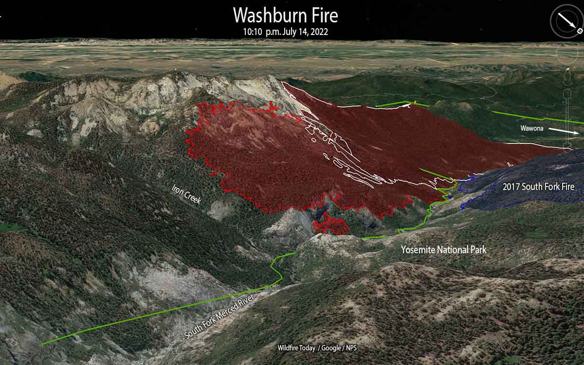
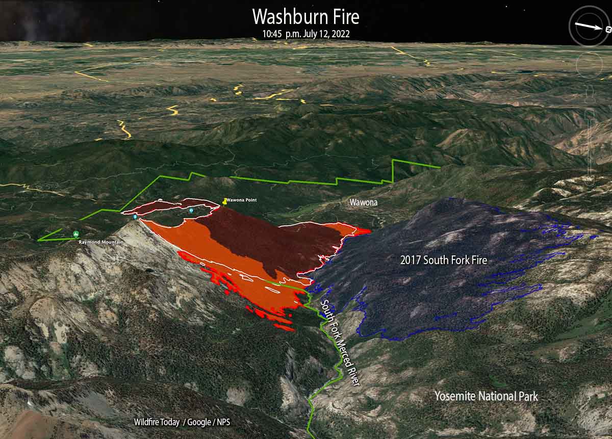
The challenge remaining on the 4,759-acre Washburn Fire in Yosemite National Park is to corral the east side where it has spread into the Sierra National Forest, a very steep area with large rock outcroppings.

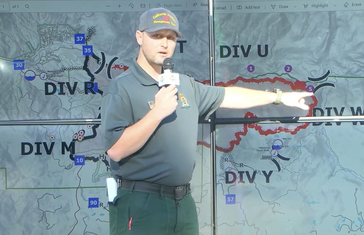
They have established three helispots on the north side of the South Fork of the Merced River and one on the south side that could be used for inserting firefighters. Their plan is to insert a small group of hotshots on the east side of the fire south of the river at Helispot 5 on the map below, being pointed to by Planning Operations Section Chief Matt Ahern. Their task will be to construct fire line on that corner, west of Iron Creek, working downhill and uphill to anchor and stabilize the fire at that point. This would then enable hotshot crews to “come off the top”, said Mr. Ahern.

Washburn Fire briefing, by Ops PSC Matt Ahern, July 15, 2022
Washburn Fire briefing by Operations Planning Section Chief Matt Ahern, July 15, 2022. He is pointing to Helispot 5 where a small group of Hotshots will be inserted to establish an anchor point on the northeast corner of the fire above the South Fork of the Merced River.

Contingency fire lines are being constructed some distance from the fire on the south and east sides in case extreme weather drives the fire in those directions.

The Buck Cabin east of the fire built in 1931, was recently rehabilitated at great expense. The wood shake shingle roof was replaced with — another wood shake shingle roof. Since it is very, very vulnerable to fire, and in a roadless area, firefighters will be flown by helicopter to the area, rappel to the ground, and wrap it in foil-based structure wrap.

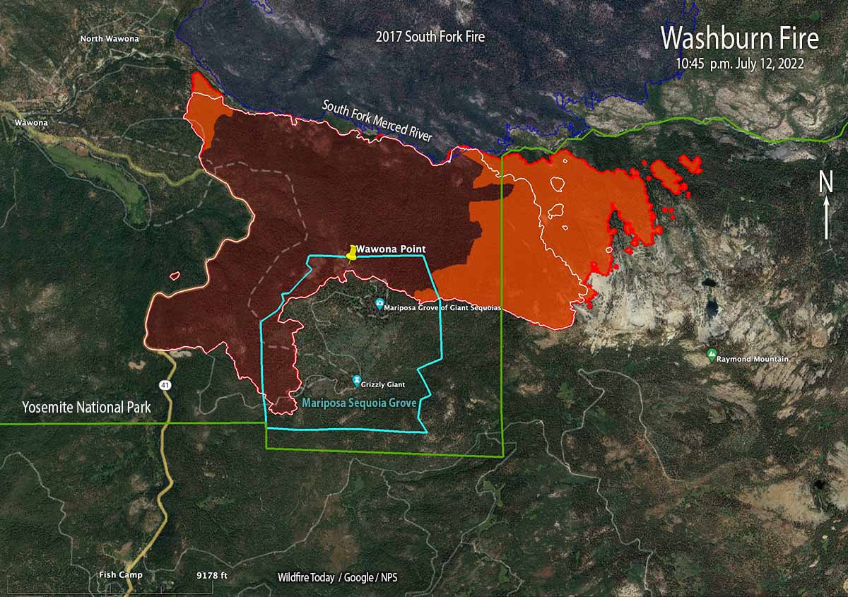
Most of the fire edge near the Mariposa Grove of giant sequoias has been secured with fire line, Mr. Ahern said.

Washburn Fire map 10:10 p.m. PDT July 14, 2022
The red line on the map was the perimeter of the Washburn Fire at 10:10 p.m. PDT July 14, 2022. The white line was the perimeter about 48 hours before.

“Overall the incident is in a very good place,” said Mr. Ahern. “We still have a tremendous amount of work and a heavy commitment of hotshot crews and aerial resources to pinch off Iron Creek.”

The infrared video below shot at 10:39 p.m. July 14 shows the east side of the fire.

Grant Fire burns 74 acres southeast of Sacramento

Grant Fire, July 14, 2022. CAL FIRE
Grant Fire, July 14, 2022. CAL FIRE.

8:09 a.m. PDT July 15, 2022

Thursday afternoon firefighters stopped the spread of the Grant Fire after it burned 74 acres about 15 miles southeast of Sacramento, California. The blaze was reported at 5:44 p.m. 4 miles northwest of Rancho Murieta just west of Scott Road. CAL FIRE reports that one outbuilding was destroyed.

Firefighters worked throughout Thursday night patrolling and building containment lines. On Friday they will continue mopping up hot spots and smoldering areas within oak groves and strengthening containment lines.

Grant Fire map July 14, 2022.

Peter Fire near Anderson, CA prompts evacuations

Updated 9:44 p.m. PDT July 14, 2022

Peter Fire map, 6 p.m. July 14, 2022
Peter Fire map, 6 p.m. July 14, 2022. FIRIS.

CAL FIRE reported at 9 p.m. that the Peter Fire at Anderson, CA has destroyed 12 structures and has burned 304 acres. They did not specify how many of the structures were residences.

Firefighting resources assigned include 51 engines, 18 water tenders, 15 hand crews, 6 helicopters, and 7 dozers for a total of 497 personnel.

The Shasta County Sheriff’s Office has evacuation information. At 8 p.m. they posted the following:

UPDATE. All residents in homes east of the intersection of Third Street and Missouri Lane to Highway 273 can return to their homes. All roads connected to Spring Gulch Road west of Missouri Lane remain under evacuation order. Residences on Diamond Street west of Franklin remain under an evacuation order. The evacuation warning for all streets off Parallel Road and Jacqueline Street remain in effect.


Updated at 6:01 p.m. PDT July 14, 2022

Air Attack reports that the Peter Fire at Anderson, California is looking good, and they have a retardant line around most of the perimeter. They are keeping two air tankers to be able to pick up spot fires as they occur. The other tankers have been released, including a Very Large Air Tanker.

The fire is believed to have started from a structure fire that spread into the vegetation. At 6 p.m. there were no engines available to work on a burning structure, so helicopters were dropping water on it.

The Shasta County Sheriff’s Department has evacuation information on their Facebook page.


Updated at 5:25 p.m. PDT July 14, 2022

Peter Fire map
Peter Fire mapped by FIRIS at approximately 4:11 p.m. PDT July 14, 2022.

FIRIS mapped the Peter Fire at 248 acres at approximately 4:11 p.m. PDT Thursday. At 5:25 p.m. it was mapped again at 303 acres.

Peter Fire photo
Peter Fire, looking southeast from the Falcon camera at 5:11 p.m. PDT July 14, 2022. AlertWildfire.

4:58 p.m. PDT July 14, 2022

air tankers Peter Fire at 4:16 p.m. July 14, 2022
Aircraft near the Peter Fire at 4:16 p.m. July 14, 2022. FlightRadar24

A new fire south of Redding, California is prompting evacuations west of Anderson. The Peter Fire was reported at around 3 p.m. PDT and at last report had burned at least 50 acres. It is four miles south-southwest of the Redding Air Attack base which results in quick turnarounds for air tankers reloading with retardant.

Firefighters on scene have reported 30 structures that are threatened and several times have requested additional engines and aircraft. There are reports that the fire has reached some structures and air tankers are making retardant drops near them attempting to lessen the damage. At least half a dozen air tankers are on scene or en route.

The evacuation center is at West Valley High School, 3805 Happy V Road, Cottonwood, CA.

Peter Fire Anderson California 5:23 p.m. PDT July 14, 2022
Peter Fire, looking southeast from the Falcon camera at 4:23 p.m. PDT July 14, 2022. AlertWildfire.

Weather

Since the fire started the Howard Street weather station in Anderson has recorded 88 degrees, 13 percent relative humidity, and 10 to 12 mph winds out of the south and south-southeast gusting to 12 mph. The forecast for the rest of the afternoon calls for winds increasing to 14 mph out of the south, then slowing after sunset to 3 mph for the rest of the night. The nighttime humidity should rise to 52 percent then on Friday drop to 10 percent in the afternoon with 6 mph winds out of the south.

Sir Charles assists in campaign to get firefighting helicopters for Lake Tahoe

Charles Barkley, Tahoe helicopters
Charles Barkley and Tahoe Douglas Fire Chief Scott Lindgren are helping to spread the word about a campaign to acquire two firefighting helicopters for the Lake Tahoe area. Still image from South Lake Tahoe Now video.

NBA legend Charles Barkley is helping the Tahoe Douglas Fire Department spread the word about a campaign to acquire two firefighting helicopters for the Lake Tahoe area in Northern California, which according to the Fire Chief is devoid of permanent helicopter coverage.

From the description and amount of funds being sought, it appears their hope is to purchase two Sikorsky S-70i Firehawk helicopters capable of carrying up to 1,000 gallons of water and also capable of responding to medical incidents with a paramedic and full advanced life support equipment. In order to have continuous coverage with a helicopter, you need at least two in a fleet to account for scheduled and unexpected maintenance.

The article below by Paula Peterson was first published on SouthTahoeNow.com.


STATELINE, Nev. – Charles Barkley remembers the American Century Championship in July 2007 very well. He and the other celebrities had arrived at Lake Tahoe to golf in the annual tournament at Edgewood Tahoe, but that year it was different.

The devastating Angora Fire started off of North Upper Truckee Road on June 24, and before it was done on July 2 it had burned through 3,100 acres, destroyed 242 residences and 67 commercial structures, damaged 35 other homes, and engaged 2,180 firefighters.

Barkley said they couldn’t “yuck” it up at celebrity golf across the lake and have fun while nearby residents were dealing with such a catastrophe. He asked NBC if he could take a camera crew into the fire-damaged area.

“I came up here 15 years ago and saw catastrophic damage. It broke my heart. I’d actually never seen fire damage before,” said Barkley.

He donated $190,000 to recovery efforts for residents over the following two years and treated firefighters and their spouses to dinner at Harrahs Tahoe.

At Edgewood Tahoe Saturday, during the 33rd annual American Century Championship, Tahoe Douglas Fire Chief Scott Lindgren held a press conference with Barkley to highlight his agency’s Operation Save Lake Tahoe.

Lindgren has said there is a giant hole in the middle of the Sierra without firefighting helicopter coverage, and that is the Lake Tahoe Basin and surrounding mountains. He wants to change that with a $60 million plan that would bring two helicopters, a station, and training to not only Douglas County, but to the whole Lake Tahoe Basin and surrounding Sierra.

Fundraising efforts have been underway for months, but much more needs to be raised.

“So anything you can do to help, please help these guys get their helicopter, please, because, hey, we can’t let nothing happen to this place,” said Barkley.

“We can’t let it happen again,” Barkley said of the Angora Fire.

For more information or to donate, visit https://tahoefire.org/helicopter.

Firefighters make progress on Washburn Fire

Threatens 3,000-year-old giant sequoia trees in Yosemite National Park

Updated 5:00 p.m. PDT July 13, 2022

Washburn Fire, photo looking NNE from Miami Peak at 4:45 p.m. July 13, 2022
Washburn Fire, photo looking NNE from Miami Peak at 4:45 p.m. July 13, 2022. AlertWildfire.

The Washburn fire in Yosemite National Park has kicked up Wednesday afternoon like it has every afternoon since it started July 7.

Helicopters have been assisting ground-based firefighters on the east side of the fire today, but due to spot fires and increased fire activity in the afternoon they called in two large and one very large air tanker to slow the spread.

A community meeting about the fire will be streamed live on Facebook at 7 p.m PDT on July 14.

The FIRIS aircraft shot video of the fire earlier today:


Updated 6:04 a.m. PDT July 13, 2022

Washburn Fire map, 3-D, 1045 p.m. July 12, 2022
Washburn Fire map in 3-D looking west. The red line was the perimeter at 10:45 p.m. July 12, 2022. The white line was the perimeter about 24 hours before. The orange areas had extreme heat at the time of the mapping flight.

Most of the fire activity on the Washburn Fire over the last 24 hours has been on the east side where it has burned out of Yosemite National Park and into the Sierra National Forest. So far crews have been able to suppress all of the spot fires on the north side that crossed the South Fork of the Merced River and ignited the five-year-old vegetation in the footprint of the 2017 South Fork Fire.

Washburn Fire map, 1045 p.m. July 12, 2022
Washburn Fire map. The red line was the perimeter at 10:45 p.m. July 12, 2022. The white line was the perimeter about 24 hours before. The orange areas had extreme heat at the time of the mapping flight.

The incident management team is evaluating the feasibility of building a fireline on the east side between Raymond Mountain and the river in order to stop the movement beyond that point.

On a flight at 10:45 p.m. an infrared line-scanning aircraft mapped the fire. An infrared analyst interpreted the data and found that it had burned 3,772 acres.

Below, another aircraft using a different system, FIRIS, reported it was 3,843 acres at 10:06 p.m. July 12. Their infrared video, looking east, is below.


Washburn Fire map 12:53 p.m. July 12, 2022
Washburn Fire map 12:53 p.m. July 12, 2022. The green lines represent all of the mapping flights by the FIRIS aircraft.

Fire crews are making progress on the Washburn Fire in Yosemite National Park — the south and west sides are starting to look more secure. At 12:53 p.m. Tuesday it was mapped at 3,516 acres.

Approximately 340 acres of the blaze is within the Mariposa grove of giant sequoias, some of which are close to 3,000 years old. The more than 500 mature giant sequoias are adjacent to heavy fuels and have so far avoided serious damage from the fire, the National Park Service reported Tuesday.

On Monday, firefighters suppressed about 15 spot fires on the west side of the fire that were across Highway 41. They now have a fire line around the Wawona community and have structure defense equipment in place.

Washburn Fire, July 10, 2022
Washburn Fire, July 10, 2022. InciWeb.

On the northeast side the line is complete from the highway down to the South Fork of the Merced River and around the community. On the north side the fire has reached the river in most places and crews are putting out spot fires as they occur across the river in the fire scar from the 2017 South Fork Fire.

The east side continues to spread. Firefighters assisted by air tankers have constructed fire line along the ridge east of Wawona Point and so far that is holding. About a mile to the east hotshot crews are evaluating the feasibility of building a fireline between Raymond Mountain and the river in order to arrest the movement beyond that point.

Yosemite Superintendent Cicely Muldoon said the fire was caused by humans.

“As you all know there was no lightning on that day so it is a human start,” Muldoon said Monday night. “It’s under investigation. That’s all I can say about that right now. We’re looking at that really hard.”

The weather for this week will continue to be warm and dry due to a strengthening high pressure system. Winds should remain light to moderate and mostly terrain driven. Temperatures will reach the low-90s and relative humidity will be in the 20-30 percent range.

Washburn Fire 4:21 p.m. July 12, 2022
Washburn Fire — looking north-northeast from the Deadwood camera at 4:21 p.m. July 12, 2022. AlertWildfire.

FBI using system to detect drones over wildfires, and the pilots

Lakeview IHC drone Operation
Lakeview Hotshots using a drone to assist with a burn operation in Alaska in 2019.

This article was first published at Fire Aviation.

The Federal Bureau of Investigation is using a new system to help wildland firefighters by detecting, identifying, and neutralizing drones that are illegally interfering with firefighting activities.

It is very dangerous to fly a drone near a fire at which helicopters or fixed wing aircraft are operating. A collision could impact the windscreen or damage the engine, props, rotors, or flight control surfaces, causing a crash. If a drone is seen near a fire the standard operating procedure is to remove all aircraft from the fire area until it is confirmed that the drone has left the scene. In other words, it interferes with firefighting efforts.

The FBI is working with the Los Angeles County Fire Department to use a system that can detect a drone flying over a fire within 30 seconds of it being launched.

From CNN:

“When the detection equipment finds the drone and identifies the operator’s location, we can very rapidly get that information to a ground intercept team who can then go make contact with that drone operator and essentially get them to stop flying that drone,” said James Peaco III, the weapons of mass destruction coordinator for the FBI’s Los Angeles field office.

With a special sensor, the team can set up a boundary as large or as small as desired and get notified if a drone flies into that area, instantly obtaining precise details such as elevation, direction, speed as well as where the drone took off from and where the controller is currently standing.

“The first thing we do is order them to bring the drone back, explain to him that there’s a wildfire and flying that drone during a wildland fire is actually a federal felony,” Peaco said.

It’s a federal crime punishable by up to 12 months in prison to interfere with firefighting efforts on public lands. Additionally, Congress has authorized the FAA to impose a civil penalty of up to $20,000 against any drone pilot who interferes with wildfire suppression, law enforcement, or emergency response operations. The FAA treats these violations seriously, and will immediately consider swift enforcement action for these offenses.

According to the US Forest Service, in 2019 at least 20 documented instances of unauthorized drone flights over or near wildfires in seven states (Arizona, California, Colorado, Nevada, New Mexico, Utah, Washington and Minnesota) resulted in aerial firefighting operations being temporarily shut down nine times. There is no centralized national mechanism to report unauthorized UAS flights over wildfires, so these are only the incidents that wildfire management agencies have become aware of, there are likely more that are not known about.

Suspending air operations could decrease the effectiveness of wildfire suppression operations, allowing wildfires to grow larger, and in some cases, unduly threaten lives, property, and valuable natural and cultural resources. The effects of lost aircraft time could be compounded by flames moving into untreated terrain.

Thanks and a tip of the hat go out to Tom and Gerald.