Images from mud flows and flooding in Southern California

We spent a few minutes on Twitter Tuesday evening looking for information about the impacts of the very heavy rain northwest of Los Angeles over the last 24 hours. The freshly barren burned hills above some of these areas contributed to the extraordinary amount of water and debris transported into the communities.

Report released on Thomas Fire Fatality

Above: A map from the report showing the entrapment location. The red line was the firefighter’s path of travel. It leads from the black circle, which was the site of the first spot fires, to a drainage.

(Originally published at 6:25 p.m. MST January 8, 2018)

CAL FIRE has released a “Green Sheet” preliminary report for the line of duty death of CAL FIRE Fire Apparatus Engineer Cory Iverson of the CAL FIRE San Diego/San Diego County Fire Authority. Engineer Iverson was overrun by fire and killed December 14, 2017 while battling the Thomas Fire in Ventura County north of Fillmore, California.

While working with a hose lay along a dozer line he was attempting to suppress a  spot fire across the fireline. As one spot fire became multiple spot fires he attempted to escape but was not successful.

The entire 2.6MB report is here. The portion of the document that describes the entrapment is below. Fire Apparatus Engineer Iverson is “FAE1” in the report.


…FAE1 responded on the assigned tactical frequency, that he saw the spot fire. He engaged the spot fire that was on the edge of the dozer line with his hand tool.

Immediately after the report of the spot fire, a second spot fire was reported approximately 20 feet into the green.

At some point, before leaving the dozer line, FAE1 dropped a 100 foot length of hose from his hose pack on the dozer line. This action left 200 feet of hose still in his hose pack.

As FAE1 reached the second spot and began to take action, it erupted. At the same time, additional spot fires erupted along the dozer line west of the original spot fire. FF1 sprayed in the direction of the spot fires. The spot fires rapidly increased in size and the hose stream was ineffective. FAE1’s escape route back to dozer line was cut off. FAE1 began traveling southwest, paralleling the dozer line. Due to fire intensity, FAE1 turned and headed down slope to the south. FAE1 made a request, on the assigned tactical frequency, for immediate air support. This was the last confirmed radio transmission by FAE1. STL1 contacted HLCO for immediate air support. HLCO responded, he had additional copters coming in and they too would begin to work the area.

At approximately 9:25 AM, FC1 reported to FAE1 on the assigned tactical frequency, additional spots were below him and he told FAE1 to “Get out of there.”

The fire intensity increased in the green along the dozer line. FF1 and FF4 retreated along the dozer line, while FF2 and FF3 retreated along the dozer line and then up into the black, towards the mid-slope road. All four FF’s dropped their hose packs on the dozer line while retreating.

At approximately 9:27 AM, FC1 declared, on the assigned tactical frequency, “Mayday, we’ve got a firefighter down.” FC1 then clarified, “We have a firefighter trapped.” STL1 confirmed with DIVS X he copied the “Mayday” of a firefighter trapped. DIVS X acknowledged the traffic with STL1 and requested, through Thomas Communications, an ALS ambulance to the address of the staging area below the avocado orchard.

At 9:28 AM, the response from Ventura County Fire Station 27 was started.

Copter 1, and two CWN copters, continued working the area below the dozer line attempting to provide an escape route for FAE1. These copters saw FAE1 retreating down through the green.

At that time, two spots erupted down slope and south of FAE1, in his path, causing him to turn southwest and start down slope toward the eventual entrapment site.

FC1 saw FAE1 fall and lost sight of him. Copter 1 also saw FAE1 fall, but get back up and continue down slope toward the eventual entrapment site.

It was described by those who saw FAE1 moving through the vegetation that the height was chest to head high; and in some cases, all that could be seen was the top of his helmet.

Prior to the fire, the vegetation height and thickness masked the view of the deep gulch in the drainage, which was the location of the eventual entrapment site.

STL1 contacted HLCO, re-confirmed a firefighter was trapped, and was told by HLCO, six helicopters were enroute.

The additional CWN copters arrived and each copter began working the area where FAE1 was last seen. Those copters dropped retardant at first, and then switched to water due to a faster turnaround time.


Thanks and a tip of the hat go out to Tom.
Typos or errors, report them HERE.

Evacuations ordered below wildfires in Santa Barbara County

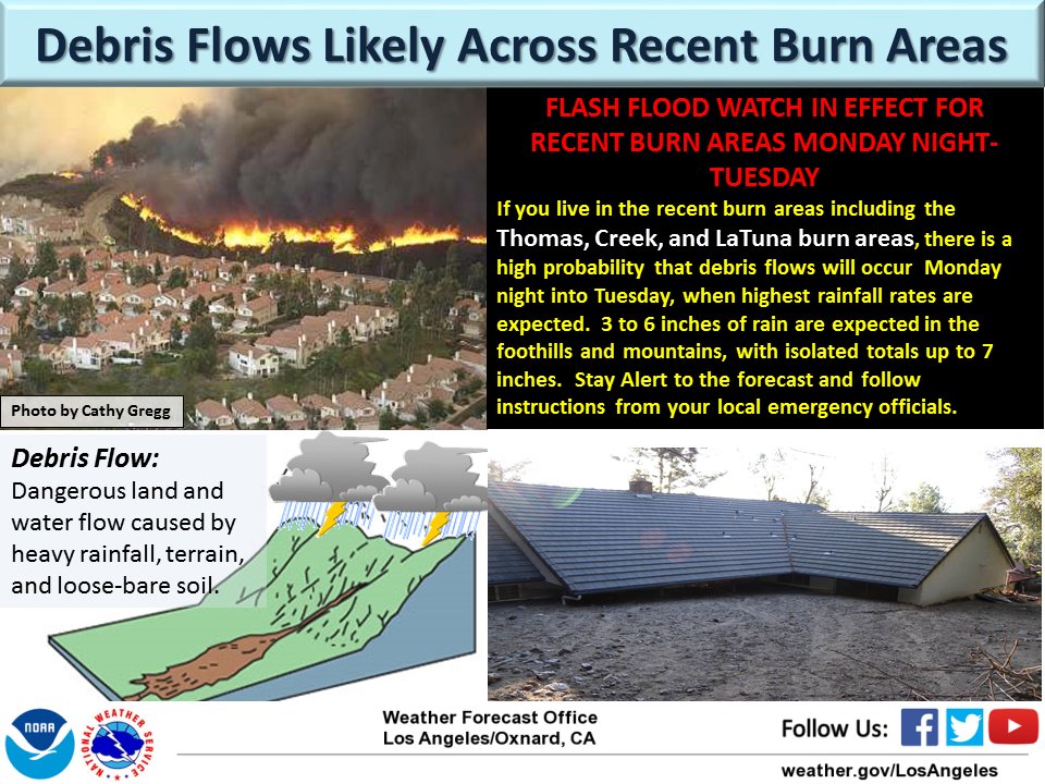
Very heavy rain could produce flash floods, mudslides, and life-threatening debris flows

(UPDATED at 12:22 PST January 9, 2018)

****

(UPDATED at 1:24 p.m. PST January 8, 2018)

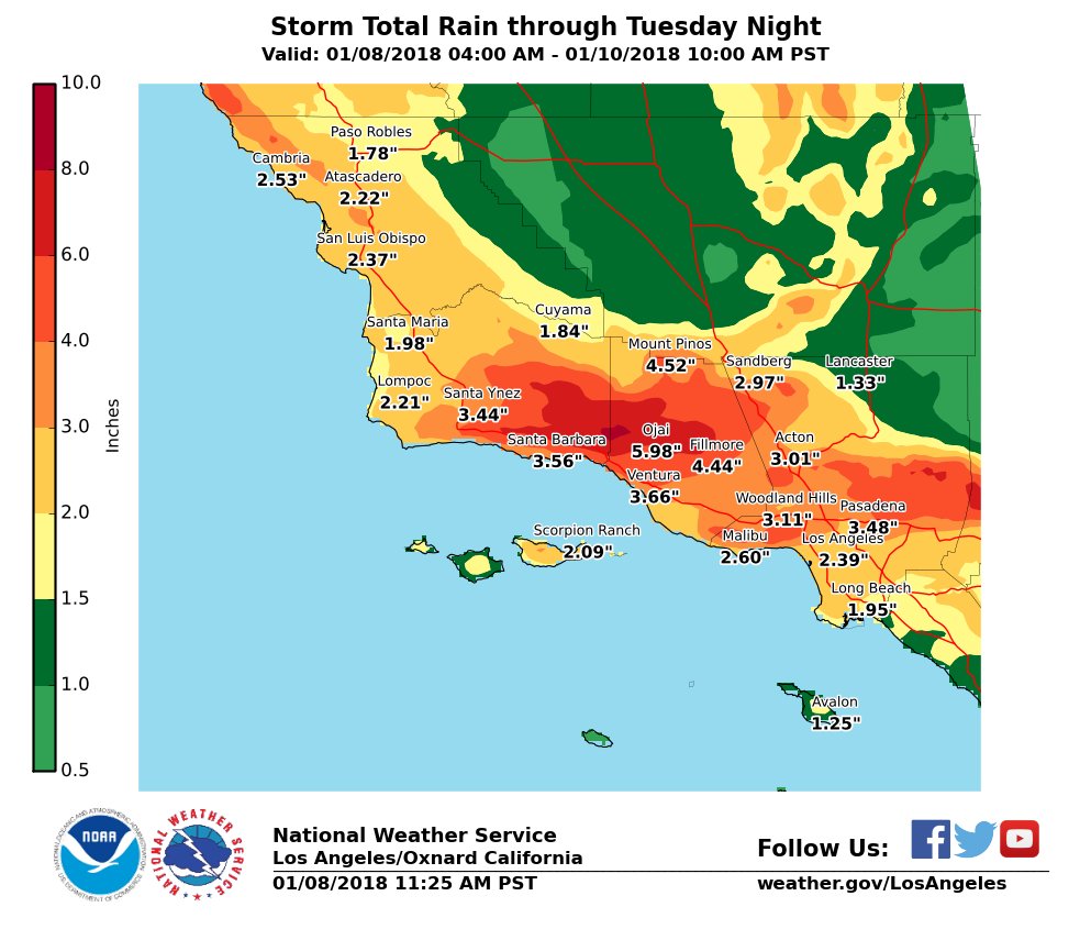
Some of the same residents who were forced to evacuate during this year’s wildfires in Southern California are being ordered to evacuate again as a very dangerous storm bears down on the area. Weather forecasters predict the Coast and valleys can expect 2 to 4″ with foothills and mountains seeing 4-7″ (locally up to 9″). Ojai, which is surrounded by the footprint of the Thomas Fire, is expected to receive 5.98″.

southern california storm total rain map

The fear is that flash floods, mudslides, and debris flows could be life threatening.

Santa Barbara County Emergency Management issued evacuation notices for areas below the Thomas, Whittier, Sherpa and Rey Fire burn areas beginning at 12 p.m. Monday, January 8. Residents can visit www.countyofsb.org and refer to the interactive map to determine if their property is affected by the notices, or call 211 or 800-400-1572 for more information.

Weather forecast for Santa Barbara
Weather forecast for Santa Barbara through Wednesday. NWS.

The very powerful storm moving into the area is resulting in not only predictions for heavy precipitation, but also strong winds. Various types of weather related warnings have been posted by the National Weather Service for the following counties: Ventura, Orange, San Luis Obispo, Santa Barbara, San Diego, Los Angeles, San Bernardino, Riverside, Monterey, and Kern. The Monday night forecast for Santa Barbara calls for 25 mph winds gusting to 38 mph out of the southwest and southeast.

warning debris flow wildfires

Last year’s California wildfires, graphically

Some people learn or are stimulated most effectively by reading, or hearing someone talk about a subject. Others, like myself, respond better visually. For me, there is truth in the old saying, “A picture is worth a thousand words”. So I can appreciate well-thought-out graphics that tell a story.

Lauren Tierney started her job with the Washington Post’s graphics department in November and yesterday she had her first graphics story published. If you click on the image in the Tweet below, the perimeters of wildfires that burned last year in California will be superimposed around an outline of the District of Columbia.

The article at the Washington Post website has additional fire-related graphics. One shows all of the 2017 fires on a map of California, and another allows you to choose which city you’d like to compare to the Thomas Fire, which became the largest in the recorded history of the state.

Frankly, when a reporter compares the size of a fire to a city, like, “The XXX Fire is the larger than Pittsburgh”, that does not mean a lot to me. But these maps take it to a new level.

I had occasional problems getting all of the graphics to render properly using the Chrome web browser, but they worked fine with Firefox.

Fuels and fire behavior advisory issued for Southern California

The lack of precipitation this fall, along with a prolonged period of warm, dry, and occasional windy weather has caused fuels to be extremely dry across portions of Southern and Central California.

Welcome to what may become the new normal — for a Fuels and Fire Behavior Advisory to be issued for an area in the Western United States hours before New Years Eve. The Predictive Services office in the Southern California Geographic Coordination Center issued one on Friday for the following areas:

  • Southern Sierra
  • Central Coast Interio
  • Central Coast
  • South Coast
  • Western Mountain
  • Eastern Mountain, and,
  • Southern Mountains

A similar Advisory that was issued two weeks ago reached its expiration date so it was reupped for another 14 days.

[pdf-embedder url=”https://wildfiretoday.com/wp-content/uploads/2017/12/12-29-2017_Fuels_and_Fire_Behavior_Advisory.pdf”]

Mapping defensive actions and exposure at the 2017 california Tubbs Fire

How effective were firefighters’ defensive actions in limiting the destruction?

The very detailed analysis below documents in a “story map” format the locations of structures that were completely destroyed or damaged when the Tubbs Fire ran through Santa Rosa, California October 8, 2017.

A primary emphasis of the analysis highlights defensive actions taken by firefighters or others. It shows structures that were only damaged on the periphery of areas that experienced total destruction. The conclusion is that the protected “boxed in” structures show successful halting of the worst effects of the fire due to exposure and defensive actions. That could be the case, however there are many factors that affect the spread of a fire in an urban environment.

We thank Geospatial Measurement Solutions, LLC who put this mapping product together. Derek McNamara, owner, said by email:

As our firefighters continue to put their lives at risk to protect all of us and fires continue to rage in Southern California, I thought it pertinent to show what they face in these situations, the consequences of their actions, and what might happen without them. I have observed that firefighters take these losses to heart and I hope this gives them some validation of their unbelievable efforts.