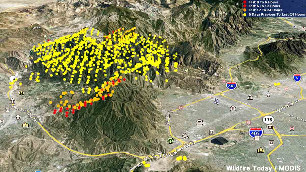
3-D Map of the Sand Fire, looking east. It shows heat detected by a satellite. The red dots are the most current, detected at 2:01 p.m. PDT July 25, 2016.
(Updated 12:34 p.m. MDT, July 26, 2016)
Officials in Los Angeles have identified the body of Robert Bresnick, 67, who was found dead Saturday in a neighborhood burned by the Sand fire.
The fire has also destroyed at least 18 homes. Many of the thousands of residents who were forced to evacuate were allowed to return home Monday night.
The Sand fire continued to rage outside of Los Angeles on Monday, and while firefighters still struggled to contain it, thousands of evacuation residents were allowed to return home.
(Maps of evacuation zones and lists of neighborhoods can be found here.)
On Tuesday the Los Angeles County Board of Supervisors is expected to declare the Sand fire — which has destroyed 18 homes and possibly killed one person — a local emergency, a declaration that usually paves the way for grant funding to help communities recover after natural disasters.
Near the city of Santa Clarita, the fire grew by more than 10,000 acres on Sunday, according to the incident management team’s Monday-morning updates. By Monday night the fire spanned more than 35,000 acres and remained only 10 percent contained.
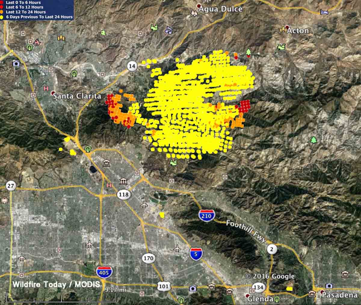
Map showing heat detected on the Sand Fire by a satellite. The red dots are the most current, detected at 2:01 p.m. PDT July 25, 2016. At that time the fire was actively spreading on the east side, as well as on the west side, east of Santa Clarita and Highway 14.Here are some updated stats on resources:
3,379 firefighters are engaged on the Sand Fire,
Resources: 435 engines, 54 hand crews, 26 helicopters, 22 dozers and 17 water tenders.
On Sunday, aircraft were briefly kept from the skies over the Sand fire when a personal drone was spotted in the area. While aircraft were only out of commission for 30 minutes (according to local media reports), this was the second time in a week that aircraft were downed because a drone. A similar incident in Montana occurred on the same day.
Thanks to wildfiretoday.com reader, Rick Baldridge, for sending us this photo, taken when the fire started on July 23.
(Updated 5:50 a.m. MDT, July 28, 2016)
The Soberanes fire in Monterey County has destroyed 34 homes, according to the Wednesday night update posted on CALFire’s information site.
The fire has already taken a heavier toll — a privately-contracted bulldozer operator died Tuesday night from injuries sustained in an accident while working on the fireline.
The fire has burned 23,688 acres and remains only 10 percent contained.
***
(Updated 5:47 a.m. MDT, July 27, 2016)
The Soberanes fire in Monterey County has triggered a local emergency declaration, which will allow affected counties to access emergency funds to help cover costs during and after the fire.
As of Tuesday night, the fire had destroyed 23,500 acres and remains 10 percent contained. It has destroyed 20 homes and continues to threaten 1,650 other structures, according to the latest information posted on InciWeb. The fire has also shut down several state parks, according to The Mercury News.
The cause of the fire is still under investigation.
***
(Updated 10 p.m. MDT, July 25, 2016)
While the Sand fire rages in L.A. County, the Soberanes fire near Big Sur in Monterey County has forced evacuations as it continues to spread with little to no containment.
Some quick stats (see more here):
16,100; 10 percent contained
1,650 structures threatened; 20 homes destroyed, 2 outbuildings
Resources:
Engines: 210
Crews: 42
Helicopters: 14
Air Tankers: 6
Dozers: 56
Water Tenders: 20
Total Personnel: 2,285
CAL Fire’s Chief Public Information Officer Daniel Berlant shared some spectacular photos on Twitter:
A fire raging in Los Angeles County destroyed at least 18 homes and killed one person, whose body was found outside of a home in Santa Clarita, according to local media reports.
Thousands of homes remain threatened as the Sand fire doubled in size from Friday to Saturday. Officials had planned to lift evacuation orders for some threatened neighborhoods, but changed their minds after an unexpected wind event, according to updates on inciweb.com.
Drones have also caused problems for firefighting efforts on the Sand fire, according to a posting from the incident management team on inciweb.com. Local media reported that a drone flying in the Bear Divide area of the Angeles National Forest suspended flight operations on Sunday for 30 minutes.
On Friday, a similar incident shutdown fire operations in Montana.
Some quick facts about the Sand fire:
Started: July 22, around 2:15 p.m. PST
Cause: Undetermined
Total personnel: 1,673
Size: 22,000 acres
Resources: 122 engines, 39 hand crews, 15 helicopters and 8 dozers.
The California Department of Forestry and Fire Protection has released what they call a “Green Sheet”, a summary of the burnover of an engine that occurred as it was making a mobile attack on the Pacheco Fire, which eventually burned 341 acres in Calaveras County south of Valley Springs.
****
“SUMMARY
On July 12, 2016, a CAL FIRE Type 3 Model 34 engine (E1) attempted to start a mobile attack toward the head of a vegetation fire. Firefighters deployed two lines, but before they could anchor and start the mobile attack, the main fire and several spot fires converged on the fire engine. One firefighter took refuge in the engine, and one firefighter ran into the green. The engine sustained damage from the fire. Neither firefighter was injured.
CONDITIONS
Weather: 89°, 21% relative humidity, winds 9 mph from the west and shifting, taken from the Campo Seco RAWS at 1400 hours.
Fuel Type: Approximately two feet tall grass.
Topography: Southeast aspect, rolling topography with multiple draws
Fire Behavior: Sheeting, fire whirls, spotting
SEQUENCE OF EVENTS
On July 12, 2016, at approximately 1314 hours, CAL FIRE and local government resources were dispatched to a vegetation fire in the vicinity of Langford Pacheco Road and Milton Road in Calaveras County. The initial report on conditions given by the Air Attack at 1329 hours was 15 acres of grass woodland and spotting out in front of the main fire. At 1356 hours, the fire was reported to be 100 acres in size and spotting under the column.
A CAL FIRE engine (E1) arrived at scene at 1345 hours and was assigned Division R, the right flank of the fire. The crew met with a Battalion Chief (BC1) and came up with a plan to create an anchor point and start a mobile attack toward the head of the fire. A second CAL FIRE Engine (E2) and Dozer (D1) were just behind E1.
As E1 crossed through a gate to make access to the fire. E1 stopped in the green and deployed a one inch THY-600 Angus line manufactured by Rawhide Fire, with a 3/8 inch tip for the mobile attack and a reel line to pick up any spot fires. The Captain (FC1) on E1 saw the engine was between the main fire and multiple spot fires. Winds were shifting and the fire behavior was erratic so FC1 from E1 gave the order to pick up the lines so they could move to a better location. As the two firefighters (FF1 and FF2) began to roll up the hose, the main fire and spot fires converged and burned up to the engine. FF1 jumped into the engine while FF2 ran away from the engine into the green, losing his helmet. FC1 lost sight of FF2, and seeing only flames, announced on the tactical frequency that a fire fighter had been burned over. Engine E2 radioed to E1 that they were heading toward them. A large fire whirl was between E2 and E1.
Uninjured, FF2 looked back toward E1 from the green and saw the under carriage of the engine was on fire. FF2 contacted E1 on the radio and told them the engine was on fire. FF1 exited the cab and used the reel line to extinguish the fire under the engine.
Flame impingement caused the airlines above the frame rails to burst. When the air pressure dropped below 60 psi, FC1 was unable to release the spring brake. FF2 ran back to E1. A helicopter dropped water around E1 while D1 constructed line around a portion of E1 to protect the crew. FC1 notified the Incident Commander that all personnel were accounted for and in a good location.
There were no injuries. E1 sustained heat damage to the tires, fenders, lens covers, air brake lines and pump panel.
SAFETY ISSUES FOR REVIEW AND LESSONS LEARNED
STANDARD FIRE ORDERS
Base all actions on current and expected fire behavior.
WATCH OUT SITUATIONS
Wind increases and/or changes direction.
Getting frequent spot fires across line.
LESSONS LEARNED
Consider topographical features and fuels, no matter how minor, in relation to you and/or your vehicle’s location to anticipate fire behavior.
Base actions on current fire situation and activity potential.
Mountain Fire, from Hwy 74, July 17, 2013. USFS Photo by Sam Wu.
The United States federal government has filed suit to recover the costs of the suppression and damage caused by the 2013 Mountain Fire that burned 27,500 acres. Most of the fire was in the San Bernardino National Forest in southern California. The lawsuit seeks nearly $25 million in damages from the owner of a Mountain Center residence and the property’s caretakers for alleged negligence that led to the fire.
The civil complaint alleges negligence and violations of California law as being the cause of the fire that started on July 15, 2013, and burned a large swath of the San Jacinto Mountains, for a time threatening the town of Idyllwild and forcing over 5,000 residents to evacuate. An investigation determined that the fire started when an electrical discharge inside of an improperly maintained electrical junction box “shot sparks and hot material out of the box and onto dry ground vegetation below,” according to the lawsuit.
Incident Management Team map of Mountain Fire, July 18, 2013 a few days before the spread was stopped.
The Mountain Fire started on property known as Gibraltar West that is owned by Tarek M. Al-Shawaf, who is the lead defendant in the lawsuit.
The defendants had a duty “to properly inspect and maintain their electrical equipment, electrical wires, and electrical junction boxes to ensure that they were safe, properly secured, and clear from dangerous conditions,” the complaint alleges.
“In addition to endangering countless lives, including those of firefighters who battle these large-scale blazes, the failure to properly manage the property and the electrical equipment on the property in this case cost taxpayers approximately $24 million dollars,” said United States Attorney Eileen M. Decker.
The complaint specifically alleges that the Forest Service spent more than $15 million to fight the fire, that the fire caused more than $9 million in damages to natural resources, and that more than $300,000 had to be spent to perform emergency rehabilitation.