Mopping up around a giant sequoia

News and opinion about wildland fire

Updated damage assessments for two recent large wildfires in California revealed that a total of 1,770 structures burned on the two fires, including 888 on the Valley Fire south of Clearlake, and 882 on the Butte Fire south of Jackson.
For the purposes of this report, “structures” includes residences, outbuildings, and commercial properties.
(UPDATE at 7:52 a.m. PT, September 21, 2015)
The latest overflight of a heat-sensing satellite at 3 a.m. PT today did not detect any large concentrations of heat on the Tassajara Fire southeast of Carmel Valley, California. That does not mean the fire is out, just that the activity has decreased to the point that the sensors, hundreds of miles above the Earth, can’t detect it.
CAL FIRE’s update at 7:35 a.m. on Monday listed the fire at 1,086 acres with 30 percent containment. There was no change in the status of damaged or destroyed structures. There are 260 personnel assigned, 35 fire engines, 7 hand crews, and 2 helicopters.
The loss of any residence is terrible, but one is especially tragic. The home of a Cachagua Firefighter, Bob Eaton, burned while he was out fighting the fire and working to save the property of others.
****
(UPDATED at 7:34 p.m. PT, September 20, 2015)
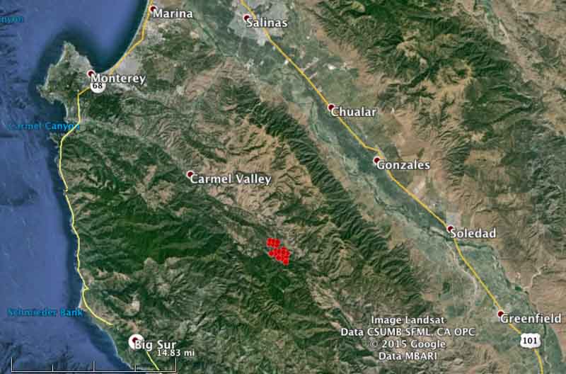
A satellite overflight at 1:01 p.m. PT on Sunday did not show much additional spread of the Tassajara Fire, which is burning 9 miles southeast of Carmel Valley in California. The area that showed the most heat was at the north end of the fire, west of East Carmel Valley Road and north of Tassajara Road.
The last update from CAL FIRE said the fire has burned 1,086 acres. They are calling it 30 percent contained. The report on structures was “10 residences damaged or destroyed, numerous outbuildings”.
CAL FIRE reported that there was a civilian fatality in the fire, but released no other details.
From the Monterey Herald late Sunday afternoon
Sheriff’s Office spokesman John Thornburg said firefighters found a car in the burn area, put the fire out, and found the body of a male of unknown age.
Slostringer shot this excellent video at the Tassajara Fire on September 19. It starts off with a retardant drop by a P2V air tanker, but be sure to watch what happens at 3:30, which illustrates a common mechanism of injury for many wildland firefighters.
r
****
(Originally published at 7:47 a.m. PT, September 20, 2015; updated at 8:47 a.m.)

The Tassajara Fire 9 miles southeast of Carmel Valley, California has burned approximately 1,200 acres, according to CAL FIRE in a late Sunday night update. The fire was reported at about 3 p.m. Saturday and grew quickly. Sunday morning CAL FIRE reported it is holding at 1,200 acres, is 10 percent contained, and 10 residences have been damaged.
The fire is just north of Jamesburg, 14 miles west of Soledad, and 13 miles northeast of Big Sur. As of 1:41 a.m. PT on Sunday it was burning west of East Carmel Valley Road, and on both sides of Tassajara Road/Conejo Grade, according to data from a heat-sensing satellite.

Resources working the fire include 5 air tankers, 2 helicopters, 35 engines, and 27 crews. CAL FIRE planned to have their fire aviation assets available or over the fire at 8 a.m. Sunday.
At about the time the fire started, the temperature at the Hastings weather station 2 miles northeast of Jamesburg was 92, the relative humidity was 15 percent, and the winds that afternoon were 8-12 mph with gusts up to 20 mph.
The forecast for Sunday calls for very warm conditions: temperature near 100, variable winds of 2-7 mph, and a relative humidity of 10-15 percent.


Mark Meyer took these photos of the Tenaya Fire shortly after it started during the evening of September 7, 2015 in Yosemite National Park. The fire eventually burned 415 acres before it was contained. It was located between Yosemite Valley and Tioga Road (Highway 120) along both sides of the Lehamite Creek Trail.

CNN shot video of tree fallers as they worked on a fire on the El Dorado National Forest in California.
CAL FIRE has updated the list of the 20 most damaging fires in the state, ranked by the number of structures burned. Two recent fires made the list, but the information for those could still change since damage assessments are not yet complete.
The Valley Fire came in at number 9 with 603 structures destroyed so far, and the Butte Fire is number 14, with 408.