Airport Fire prompts evacuations in Owens Valley, California

About half of Big Pine is under evacuation orders

Updated 2:17 p.m. PT Feb. 17, 2022

Airport Fire 11:27 a.m. PT Feb. 17, 2022
Airport Fire, photo posted at 11:27 a.m. PT Feb. 17, 2022 by @captain2500agl

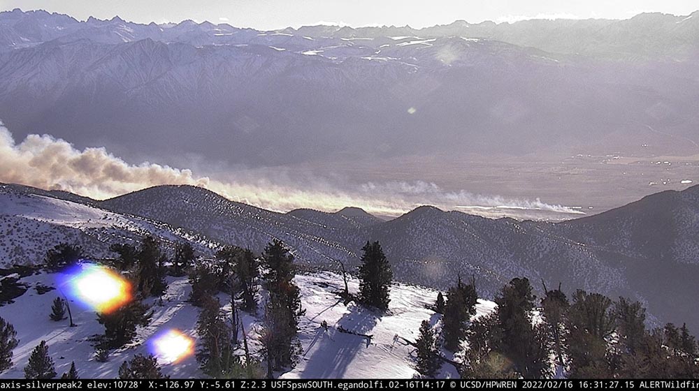
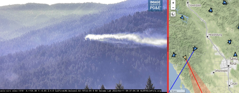
The growth of the Airport Fire slowed substantially by mid-day Thursday, judging from photos taken in the morning and afternoon. There are still a few residual smokes showing in the image shot by the camera on Marzano Peak at 1:56 p.m., but no dark gray columns.

Airport Fire 1:56 p.m. Feb. 17, 2022
Airport Fire, from the Marzano Peak camera at 1:56 p.m. Feb. 17, 2022 looking west-southwest.

Caltech, the operator of the Owens Valley Radio Observatory, said that as of Thursday morning at 11 a.m. personnel were reporting that a perimeter had been established around buildings and the main threat to the structures had passed. Assessment of instrumentation and antennas in the field surrounding the main facility structures, however, was ongoing.

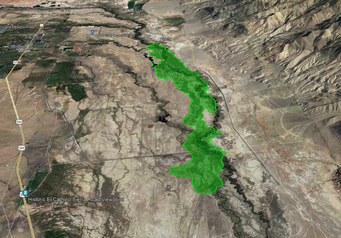
CAL FIRE said at 9:53 a.m. Thursday that the Airport Fire had burned 3,900 acres.


Updated 9:47 a.m. PT Feb. 17, 2022

Map, Airport Fire, 8 a.m. PT, Feb. 17, 2022
Map, Airport Fire. The red area shows the location of the fire mapped Wednesday afternoon by FIRIS. The red squares represent heat detected by a satellite at 8 a.m. PT, Feb. 17, 2022.

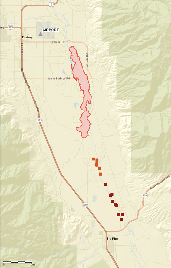
The map of the Airport Fire above is more accurate than our earlier map.


9:10 a.m. PT Feb. 17, 2022

Map of the Airport Fire 2:15 a.m. Feb. 17, 2022
Map of the Airport Fire showing heat detected by a satellite as late as 2:15 a.m. Feb. 17, 2022. The yellow dots exaggerate the extent of the fire, at least in its width. Many of the yellow dots are very questionable. The red dots appear to be more accurate. The gap between the yellow and red dots is likely the result of the light vegetation burning and cooling between the two satellite passes, which were about 11 hours apart.

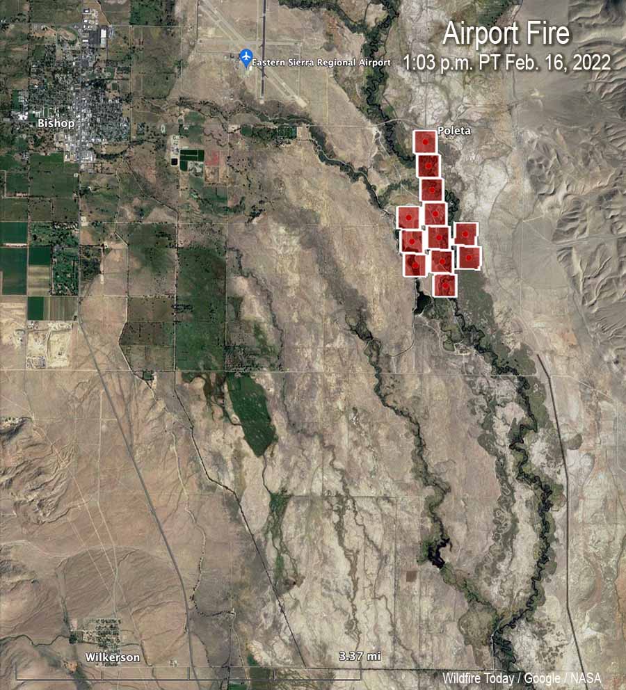
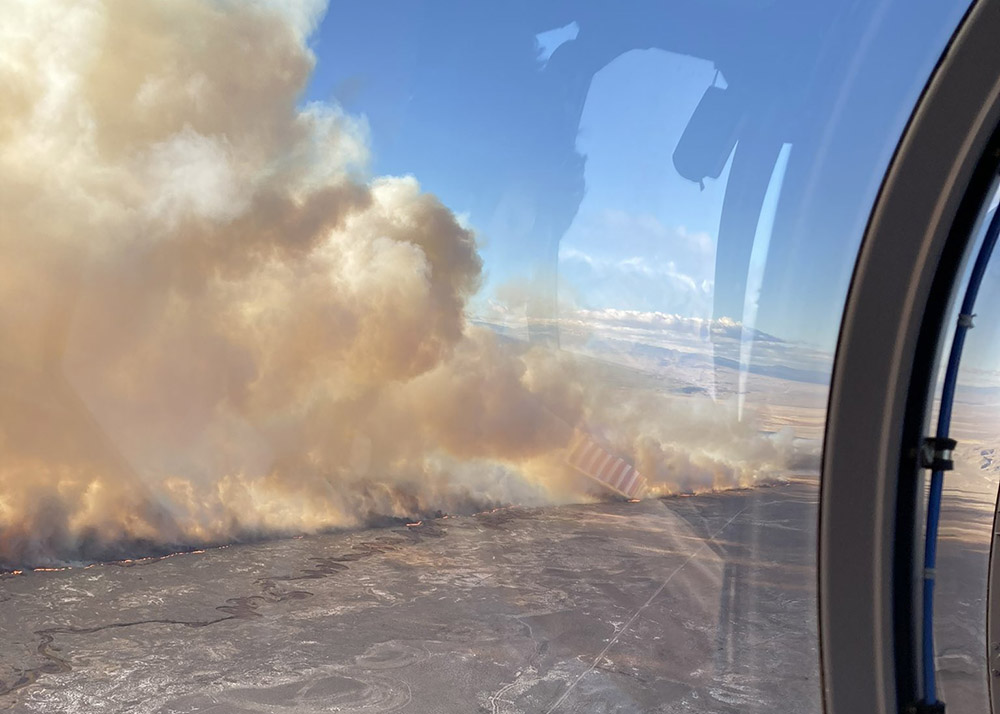
The Airport Fire was very active Wednesday night. When the sun rose Thursday it spanned for about 13 miles from the airport in Bishop, California south to Big Pine. CAL FIRE reports that evacuations have been ordered for properties in Big Pine that are east of US Highway 395. The town has a population of about 1,500.

(To see all articles on Wildfire Today including the most recent, click https://wildfiretoday.com/tag/airport-fire/)

CAL TRANS closed Highway 168 from the junction of 395 in Big Pine to Death Valley Road.

CAL FIRE said at 7 a.m. Thursday it had burned 2,800 acres as it spread south through the Owens Valley.

The photo in the tweet below which was taken from Big Pine was posted at 7:05 a.m. Thursday.

CAL FIRE dispatched six S-2 air tankers Thursday at about 8 a.m.

Areas that are threatened include two research facilities, White Mountain Research Center and Owens Valley (Caltech) Radio Observatory. Both were evacuated Wednesday.

The blaze started Wednesday afternoon near the Eastern Sierra Regional Airport at Bishop.

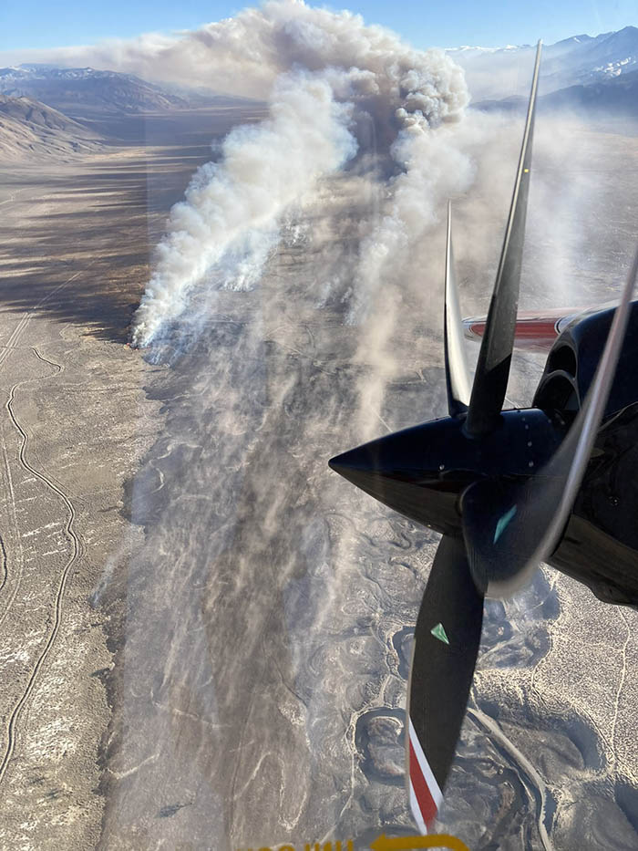
Photos taken from Marzano Peak early Thursday morning showed active fire near Big Pine. In the southernmost area of the fire dense, dark smoke was visible which could indicate heavy fuels, such as structures or vehicles burning.

Airport Fire, 6:15 a.m. Feb. 17, 2022
Airport Fire, from the Marzano Peak camera at 6:15 a.m. Feb. 17, 2022 looking west-southwest.
Airport Fire 9:07 a.m. Feb. 17, 2022
Airport Fire, from the Marzano Peak camera at 9:07 a.m. Feb. 17, 2022 looking west-southwest.

The wind, which on Wednesday was out of the north at 28 mph gusting up to 50 mph, slowed during the night but was still strong, 15 to 22 mph gusting at 26 to 32 mph with the relative humidity in the mid-30s. At 8:20 a.m. Thursday the Big Pine weather station recorded 15 mph north-northwest winds gusting to 21 mph while the relative humidity was 40 percent.

The forecast for Big Pine on Thursday is for 56 degrees, 16 percent relative humidity in the afternoon, and 10 to 14 mph winds out of the northwest gusting until noon at 20 mph. These conditions will be conducive to active spreading of the fire, as long as the fuel is continuous.

Resources assigned to the fire Thursday morning include 66 fire engines, 7 water tenders, 1 helicopter, 16 hand crews, and 7 dozers for a total of 432 personnel.

Airport Fire spreads rapidly southeast of Bishop, California

Spreading south, pushed by strong winds

6:19 p.m. PT Feb. 16, 2022

Map, Airport Fire
Map, Airport Fire at approximately 5 p.m. Feb. 16, 2022, looking north. By FIRIS aircraft, via Muni-Captain.

A fire in the northern end of California’s Owens Valley has burned about 2,156 acres, according to the FIRIS mapping aircraft at 4:45 p.m. PT Wednesday.

(To see all articles on Wildfire Today including the most recent, click https://wildfiretoday.com/tag/airport-fire/)

The incident is three miles east of Bishop and one mile southeast of the Eastern Sierra Regional Airport. Aircraft are having difficulty flying safely and dropping retardant accurately in the very strong winds gusting out of the north at 28 mph gusting at 32 to 50 mph while the relative humidity is 30 percent.

Map, Airport Fire
Map, Airport Fire, heat detected by satellite at 1:03 p.m. Feb. 16, 2022.

The wind is pushing it to the south. The CHP reports it has crossed Collins Road, which is five miles south of Bishop.

CAL FIRE reported at 5:38 p.m. that the town of Big Pine is being evacuated. The agency said the evacuation center is at the Bishop Senior Center, 506 Park Ave., in Bishop.

Airport Fire
Airport Fire, posted by CAL FIRE BDU at 4:54 p.m. Feb. 16, 2022.

Below is video, visual and infrared, of the Airport Fire southeast of Bishop, California at 4 p.m. PT Feb. 16, 2022. Shot by the Orange County FIRIS aircraft, Intel 12. When in infrared mode, the bright white areas represent heat from the fire.

Airport Fire
Airport Fire, posted by CAL FIRE BDU at 4:54 p.m. Feb. 16, 2022.
Airport Fire
Airport Fire, as seen from the Silverpeak 2 camera at 4:31 p.m. Feb. 16, 2022.

Infrared video mapping of the Emerald Fire near Laguna Beach, California

The blaze burned 154 acres, coming very close to homes

Emerald Fire map
Still image from the video below of the Emerald Fire, from the FIRIS mapping aircraft at 1:46 p.m. PT Feb. 11, 2022.

The Emerald Fire near Laguna Beach, California was mapped by the Fire Integrated Real-Time Intelligence System (FIRIS) aircraft. The video below was recorded at 1:45 p.m. February 11, day two of the fire. The image switches back and forth from thermal infrared to regular video, with heat showing up as bright white. This data can help firefighters know where to concentrate their containment and mop up efforts.

After the fire was reported Feb. 10, 2022 at about 4 a.m. in the Laguna Coast Wilderness Area, strong winds pushed the blaze near homes in the Emerald Bay area of the coastal city. It ultimately burned 154 acres, coming very close to homes, as you can see in the video.

In the aircraft were Peter Cain (Pilot), Matt Hedman of AEVEX on the controller, and Air Tactical Group Supervisor Steve Price providing narration.

Map Emerald Fire, Feb. 10, 2022 Laguna Beach California
Map Emerald Fire, Feb. 10, 2022.
map Emerald Fire near Laguna Beach
Map showing the location of the Emerald Fire near Laguna Beach in Southern California, Feb. 10, 2022.

Sheriff’s helicopter helps guide firefighters to a wildfire Thursday night in Northern California

The Terrace Fire is near Monte Rio, northwest of Santa Rosa

10:31 a.m. PST Feb. 11, 2022

fire near Monte Rio Northern California
Using its spotlight, Sonoma County Sheriff’s Office helicopter Henry 1 directs firefighters to a fire near Monte Rio in Northern California. As seen from the Alert Wildfire camera at Siri, in infrared mode at 10:32 p.m PT Feb. 10, 2022.

Firefighters in Northern California had assistance from a Sonoma County Sheriff’s helicopter Thursday night as they were finding the best route to hike to the Terrace Fire near Monte Rio. It was reported at about 9 p.m. on a slope above Highway 116. The helicopter known as Henry 1 used its spotlight  to direct the personnel as they hiked through the densely forested area.

When crews reached the blaze at about 11 p.m. they reported it had burned about one acre. Friday morning the Alert Wildfire camera at Siri showed that it is still generating a fair amount of smoke which is being blown close to the ground by the wind.

smoke from a fire in Sonoma County near Monte Rio
Image of smoke from a fire in Sonoma County near Monte Rio as seen from the Alert Wildfire camera at Siri, 9:37 a.m. PT Feb. 11, 2022. The intersection of the lines from the two camera locations indicate the approximate location of the fire.

The fire is about 14 miles west-northwest of Santa Rosa.

The Press Democrat reported Friday morning that Stephane Lunsford, a public information officer for CAL FIRE, said crews had completed a line around 85 percent of the fire.

Kent Porter (@kentphotos) shot some very interesting photos Thursday night. Here are a couple. Click on them twice to see larger versions:

Our take:

A one-acre fire is not huge news. We don’t often hear about fires like this. But it’s an example of how firefighters are usually successful in keeping fires small, even when it requires hiking for hours at night through dense woods to find and then put out a fire.

In addition, it’s a fire in early February, far outside the traditional fire season in Northern California. But also the images are fascinating — the infrared photo showing the spotlight from the helicopter, smoke from the fire the next morning, and especially the great photos taken by Mr. Porter.

Emerald Fire burns more than 100 acres near Laguna Beach, California

Hundreds of residents were evacuated before dawn Thursday

Updated at 10:08 p.m. PT Feb. 10, 2022

Map Emerald Fire, Feb. 10, 2022 Laguna Beach California
Map Emerald Fire, Feb. 10, 2022.

Thursday morning firefighters stopped the spread of the 145-acre Emerald Fire northwest of Laguna Beach in Southern California. At the peak of activity there were 220 personnel assigned, plus numerous helicopters and fixed wing aircraft.

All of the evacuation orders were lifted at 3 p.m. and no structures were destroyed. Areas in the interior of the fire are still burning, fire officials said Thursday afternoon, and the predicted hot, dry weather means they will have to continue to monitor, mop up, and improve containment.

The last time the area burned was during the Laguna Fire of 1993 which covered 14,337 acres, enveloping almost the entirety of Crystal Cove State Park and Laguna Coast Wilderness Area.

A spokesperson for the fire said good clearance of vegetation around the homes made it much easier for firefighters to prevent any structures from burning.

Fire personnel will be on scene Thursday night and fresh troops will arrive Friday morning.


1:04 p.m. PT Feb. 10, 2022

map Emerald Fire near Laguna Beach
Map showing the location of the Emerald Fire near Laguna Beach in Southern California, Feb. 10, 2022.

Evacuation orders for the Emerald Fire prompted hundreds of residents in Laguna Beach in Orange County, California to leave their homes before dawn Thursday. Reported at about 4 a.m. in the Laguna Coast Wilderness Area, strong winds pushed the blaze near homes in the Emerald Bay in the coastal city.

As the fire was spreading, a weather station at Moro Canyon recorded 15 to 22 mph winds gusting out of the north-northeast up to 43 mph while the relative humidity was 31 percent. Those conditions are conducive to rapid fire spread and would have pushed the fire to the south-southwest. When the winds subsided later in the morning firefighters were able to stop the spread. Preliminary estimates put the size at about 140 acres, but that could change with more accurate mapping.

“We no longer have a fire season. We have a fire year,” said Orange County Fire Authority Chief Brian Fennessy in a news conference Thursday morning. “It’s February 10. This is supposed to be the middle of winter and we’re anticipating 80 to 90 degree weather. Even though the hillsides are green it doesn’t take but low humidity and wind to cause fires to occur. If this is any sign of what’s to come throughout the rest of the winter and spring we’re in for a long year.”

Two weather advisories are in effect for much of Southern California on Thursday, including the Emerald Fire area; one is for wind and another for heat. The forecast for the Laguna Beach area for Thursday morning called for northeast winds of 15 to 25 mph with gusts to 45. The heat advisory predicted high afternoon temperatures of 91 degrees.

Thanks and a tip of the hat go out to Jim.

Wildland firefighter to compete in Winter Olympics

Robby Burns — parallel giant slalom

Robby Burns firefighters Olympics snowboarder
Robby Burns photo, posted Jan. 28, 2020.

A wildland firefighter will be competing in the Winter Olympics in China. Robby Burns grew up near Mount Shasta, California and has been a professional snowboarder for the last five years. He was a lead firefighter on the Shasta Lake Interagency Hotshots from 2013 to 2015. This past summer, he worked on an engine crew assigned to the Dixie Fire, Salmon River Complex, Corral Complex, Forks Complex, Mad River Complex, and Gasquet Complex. According to the US Forest Service, Mr. Burns recently accepted a position on the Shasta Lake Interagency Hotshot Crew.

“Robby was an integral part of the success of the crew,” said Joe Bogdan, Shasta Lake IHC superintendent. “We deeply respect the sacrifices he has made and his discipline to achieve his goals. We created lifelong and battled-tested relationships through our time working together.”

Robby Burns firefighters Olympics snowboarder
Robby Burns (on right), posted Sept. 15, 2021. Robby Burns photo.

On his website he describes himself as “snowboarder, firefighter, speaker.”

The 31-year old will be competing in the Parallel Giant Slalom event February 7th PT. Qualifications begin at 7 p.m. PT with the subsequent races continuing through the night, U.S. time. (Update Monday Feb, 7: NBC is showing the event starts Monday at 9:40 p.m. ET, 6:40 p.m. PT. Times are subject to change due to weather and other factors.)

When he leaves the starting gate in Beijing, he will be wearing his Shasta Lake IHC buckle, which he earned after completing his third season on the crew.

In January of 2020 Mr. Burns finished first in the Nor-Am Cup Parallel Giant Slalom race in Steamboat Springs, Colorado.

In November he sustained a leg injury after falling when he was training in Northern Canada. It put him on crutches and resulted in him missing the first stop of the World Cup tour in Russia.

On November 30, 2021 he wrote on his Facebook page, “Yesterday I made it from two crutches to one! Feels like I just graduated kindergarten! While it was a scary injury to my knee, the pictures say all the real important stuff still works good. With 2 weeks of intense PT the doc says he thinks I’ll be right as rain. So, while the “ship” isn’t moving at full speed, I’ll be moving full speed at this snail pace for a little while. But I’m in the best place to do this work. And sometimes life has a way of telling us to slow down.”

About 16 days after writing he was on one crutch, he competed in a World Cup snowboarding event in Carezza, Italy finishing 42nd of the 70 who qualified. Mr. Burns appeared in two more races in Europe in January finishing 43rd and 53rd. Currently he is ranked 30th in the FIS Snowboard Points List.

Robby Burns firefighters Olympics snowboarder
Robby Burns, photo, posted Jan. 21, 2022.
Robby Burns firefighters Olympics snowboarder
Robby Burns at the Olympics Opening Ceremonies. Robby Burns photo, posted Feb. 4, 2022.

In 2014 another member of the Shasta Lake Hotshots was mentioned on the pages of Wildfire Today when Steven Woodlief bought a $2 ticket in the California state lottery and won $1.3 million, $1,000 a week for life. At the time Mr. Woodlief said he would buy a new truck.

Thanks and a tip of the hat go out to Jim and Kevin.