Round Fire in California causes evacuations

(UPDATE at 7:50 a.m. PST, February 10, 2015)

Beginning on Monday residents were allowed into the fire area. It is still reported to be 7,000 acres and the Incident Commander is calling it 95 percent contained. This will be our last report on the fire unless there are major new developments.

(UPDATE at 1:30 p.m. PST, February 8, 2015)

CAL FIRE Public Information Officer Daniel Berlant confirmed that 40 residences burned in the Round Fire north of Bishop, California. An additional five were damaged. Their web site has been reporting that “40 residences and outbuildings” were destroyed.
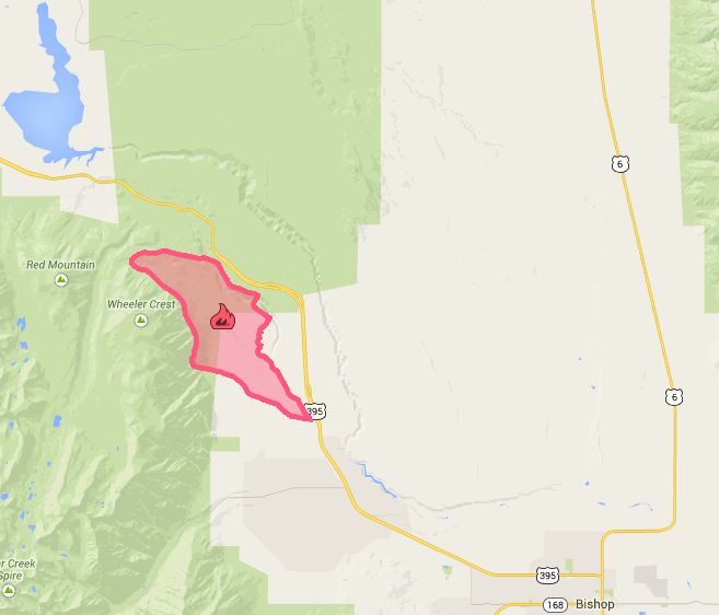
Map, Round Fire
Click HERE to view a zoomable version of the map of the Round Fire.

****

(UPDATED at 8:45 a.m. PST, February 8, 2015)

Round fire
Round Fire February 6, 2015. Jim Stimson photo via J.McDavid and @bbdd333.

There has been no major change in the status of the Round fire north of Bishop, California. It is still listed at 7,000 acres but the incident commander has raised the containment to 65 percent.

CAL FIRE has still not broken down the number of residences vs. outbuildings that have been destroyed. They are lumped together for a total of 40.

Evacuations still remain in effect. Downed power lines make re-entry hazardous for homeowners. Trees damaged by fire are being assessed and tagged as hazards for removal.

The county sheriff’s office has assembled a list of resources for residents affected by the fire.

Round Fire
Round Fire. Photo via Inyo County Sheriff.
Round Fire map 2-7-2015
Click here to download a higher-res version of this map.

****

(UPDATED at 6:10 p.m. PST, February 7, 2015)

The Associated Press is quoting CAL FIRE Captain Liz Brown a saying “40 residences and several outbuildings were destroyed” in the Round Fire north of Bishop, California.

CAL FIRE is saying “40 residences and outbuildings” were destroyed.

The Incident Commander is calling it 7,000 acres and 50 percent contained.

The Owens Valley weather station has recorded rain off and on since midnight, with the latest being 0.06 inch between 1 and 2 p.m. today.

****

(UPDATED at 10:06 a.m. PST, February 7, 2015)

CAL FIRE has revised the size of the Round Fire. Now they say it has burned 7,000 acres. The 133 percent increase, from 3,000 acres reported at 7 a.m., was due to better mapping.

****

(UPDATED at 9:05 a.m. PST, February 7, 2015)

The Round fire north of Bishop, California has burned 3,000 acres and 20 structures and outbuildings, according to a Saturday morning update from CAL FIRE.

The towns of Paradise and Swall Meadows are still under a mandatory evacuation order. Downed power lines and venting propane tanks make re-entry for residents dangerous.

Significant rainfall stopped the forward spread of the fire around 2 a.m. on Saturday. The area continues to receive a small amount of rain Saturday morning — 0.01 inch between 7 a.m. and 9 a.m.

The Incident Commander is calling it 30 percent contained.

****

(UPDATED at 7:25 a.m. PST, February 7, 2015)

Round Fire 3D map
A 3D map of the general location of the Round Fire west of Highway 395. The green line is the county line. (click to enlarge)

The Round Fire north of Bishop, California near Swall Meadows and Round Valley has burned one residence and an outbuilding, according to information from CAL FIRE at 9:15 p.m. on February 6. The fire had burned 500 acres at the time of their report. It started at about 2 p.m. on Friday.

A satellite flyover at 12:30 a.m. PST on Saturday detected some scattered heat in the Swall Meadows area, but the relatively light fuels will not retain heat for very long, making it difficult for the infrared equipment on the satellite to detect heat hours after the fire passes through an area.

On Friday the strong winds made it impossible for fixed or rotary wing aircraft to work the fire.

Between midnight and 6 a.m. on Saturday the Owens Valley weather station recorded 0.27 inch of precipitation. Saturday morning the chance of rain is predicted to be 100 percent, but by 10 a.m. it should decrease to 46 percent. Throughout the day on Saturday the additional precipitation could amount to about 0.05 inch.

According to CALTRANS Highway 395 is open, after being closed earlier due to the fire. The wind warning for high profile vehicles has also been dropped.

****

Round Fire
Round Fire. Photo by California Dept. of Transportation.

(Originally published at 6:10 p.m. PST, February 6, 2015)

A vegetation fire north of Bishop, California west of Highway 395 has required the evacuation of two communities in the northern portion of the Round Valley area. Residents of Swall Meadows and Paradise approximately 10 miles north of Bishop are under mandatory evacuation orders.

At about 5:45 p.m. local time the Inyo County Sheriff Office said that the fire had burned 100 acres.

A CAL FIRE update said erratic winds have caused the fire to spread in variable directions. There is an unconfirmed report that at one point winds were gusting to 70 mph. Highway 395 was closed to high profile vehicles at 7 p.m. local time due to the wind.

Round Fire
Round Fire. Photo by Inyo County Sheriff’s Office.

Agencies responding include CalFIRE, Bishop Volunteer Fire Department, CHP, Paradise Volunteer Fire Department, Forest Service, BLM, and Inyo Sheriff’s Office.

An evacuation center has been established at the Crowley Lake Community Center, at 458 S. Landing Rd Crowley Lake, CA.

Friday morning the National Weather Service issued the following wind warning. The fire started in the upper-right of the map, north of Bishop.

NWS wind advisoryPrecipitation shows up on radar east of the area, and the weather forecast predicts a 53 percent chance of rain after midnight, with accumulations of about 0.10 inch by dawn. The forecast calls for 17 mph southwest winds gusting to 26, decreasing after midnight to 1 to 7 mph, with the relative humidity over 80 percent.

Angeles National Forest Supervisor transfers months before retirement

Tom Contreras Angeles National Forest
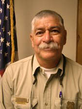
Tom Contreras, former Forest Supervisor of the Angeles National Forest. USFS photo.

The Forest Supervisor of the Angeles National Forest transferred into a different job in mid-January months before he is scheduled to retire this spring. Tom Contreras is now serving as an assistant to the Regional Forester in Vallejo, California across the bay from San Francisco.

After Mr. Contreras left, an acting Forest Supervisor was appointed to temporarily fill the position — Daniel Lovato, currently the Deputy Forest Supervisor of the Angeles National Forest.

Mr. Contreras became the Forest Supervisor of the Angeles NF north of Los Angeles after Jody Noiron, who had been in the position since 2000, was transferred to a similar position on the nearby San Bernardino National Forest in October 2010 just days before a Congressional panel held a hearing amid accusations of mismanagement of the 2009 Station fire that burned 160,000 acres and killed two firefighters.

The Angeles National Forest was criticized for a very timid, less than aggressive response to the Station Fire, especially the morning of the second day when at just a few acres, Air Attack thought it could be stopped with the three air tankers that he requested to be over the fire at 7 a.m., but that request was not filled. Neither were the three requests he put in for a Very Large Air Tanker. Night flying helicopters were not used during the first night. Soon after 9 a.m. the fire took off and burned 160,000 acres.

The fire started weeks after the U.S. Forest Service distributed a memo requiring fire managers to consider using USFS resources rather than state and local fire equipment and personnel in order to save money.

The U.S. Forest Service’s report on the Station Fire found nothing to criticize about how the fire was managed in the first 46 hours, and said policies and procedures were followed. The Government Accountability Office (GAO) released a report on the fire that looked at number of issues and put forward some suggestions.

Articles on Wildfire Today tagged “Station Fire”.

Thanks and a tip of the hat go out to Dave.

Five fires started from escaped burn piles near Eldorado National Forest

Eldorado National Forest fireOn Saturday, January 24, five fires were ignited by burn piles that escaped on private timber lands near the Eldorado National Forest in northeast California. Two of the fires burned 33 acres each. The piles were originally ignited in December. Judging from the photos and reports from firefighters, the fire behavior was impressive for January.

In 2014 the El Dorado NF only had one fire that required a Type 3 Incident Commander. That was the King Fire fire east of Placerville, California where 12 firefighters deployed their fire shelters in front of advancing flames and were directed to safety by a helicopter pilot.

These excellent photos were taken by Michael Loeffler, an Engine Captain on the Eldorado NF.

Eldorado National Forest fire Eldorado National Forest fire

Eldorado National Forest map

Six alarm vegetation fire causes evacuations south of San Francisco

Pacifica fire
An early morning vegetation fire forced the evacuation of 80 homes and condos in the Pacifica area south of San Francisco Monday morning. It was reported at about 3:35 a.m. near Fassler Avenue at Highway 1 and was contained around 8 a.m., after which the evacuation was lifted. Pushed by a 15 mph wind, the fire burned about five acres in a heavily wooded area.

Pacifica fire

15 instructors at CAL FIRE’s Ione academy fired or disciplined

Orville Fleming
Orville Fleming

The investigation into the murder of the girlfriend of a California Department of Forestry and Fire Protection instructor who worked at the state’s fire academy has resulted in a series of dominoes falling. Two firefighters have been fired, the resignation of a third was accepted, and 13 others will be disciplined. Of the 16 firefighters, 15 were instructors at the academy and the other worked in the field.

Battalion Chief Orville Fleming was found and arrested in October after a 16-day manhunt. An instructor at the agency’s training academy at Ione, California, the 55-year old BC had been charged in the May 1 stabbing death of 26-year old Sarah Jane Douglas, his live-in girlfriend.

Mr. Fleming’s wife had said he and other firefighters had engaged in sex with prostitutes at the academy and said she had seen a tape of such activities. However investigators were not able to find any evidence of the tape.

After the murder Mr. Fleming ditched his CAL FIRE truck and disappeared but was found 16 days later when he left his hideout near his home and boarded a bus to obtain food.

More details are at the Sacramento Bee.

UPDATE: In July, 2015, Mr. Fleming was found guilty of second-degree murder and sentenced to 16 years to life in prison.

Thanks and a tip of the hat go out to Dick.

Report on Upper Lyons Prescribed Fire Entrapment and Fire Shelter Deployment

Fire shelter deployment site
Fire shelter deployment site. Photo from the FLA.

The Wildland fire Lessons Learned Center has published a facilitated learning analysis for an entrapment and fire shelter deployment that occurred on the Upper Lyons prescribed fire last October in Redwood National Park in northern California.

Below is the one-page summary of  the 27-page document, which can be read in full HERE (1.3MB).

****

“Number and type of injuries

One individual with second degree burns to the left hand and first degree burns to the right hand and face.

Narrative Summary

On October 13, 2014, firefighters were conducting a prescribed fire in the Bald Hills Area of Redwood National Park.

Crews were burning off of a handline when a combination of factors aligned to cause several spot fires in heavy fuels outside the unit. These spot fires burned together to form multiple slopovers.

A decision was made to suspend ignition until an assessment of the slopovers could be completed. At approximately that same time, a firefighter who was hiking up the fireline became entrapped due to intense heat and dense smoke. As a result, this firefighter deployed their fire shelter on the handline.

The firefighter was quickly located and escorted a short distance out of the smoke and heat. The firefighter, immediately assessed by an onsite paramedic, was able to walk—with some assistance by others—to an area where a vehicle was waiting to transport them to a landing zone.

The firefighter, accompanied by a flight nurse, was airlifted to Shasta Regional Hospital for treatment. The firefighter was released a short time later and referred to the University of California Davis Burn Center for follow-up the next day.

The diagnosis from the specialist at the burn center was second degree burns to the left hand and first degree burns to the right hand and face. Over the next several weeks, the firefighter received follow-up treatment at the burn center.

Significant Note

During the Facilitated Learning Analysis (FLA) process, the firefighter continued to emphasize the profound role that previous fire shelter training played in the successful deployment of the firefighter’s shelter during this event.”