Below is this week’s Situation Report from the California Department of Forestry and Fire Protection.
Tag: California
Two fires in Yosemite; one threatens structures
(UPDATED at 8:50 a.m. PDT, July 31, 2014)
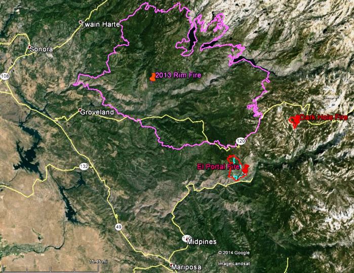
The map above shows the perimeters, in red, of the El Portal and Dark Hole Fires in Yosemite National Park. The blue line was the perimeter of the El Portal fire about 48 hours earlier. The 2013 Rim Fire can be seen north of those two fires.
The El Portal Fire added another 300 acres on Wednesday when it ran for over half a mile in the Crane Creek area, bringing the total to 4,200 acres.
There was rain on the Dark Hole fire on Wednesday, allowing only an additional 11 acres of growth.
Approximately 1,063 personnel are assigned to the fire.
As of Wednesday night, the Big Oak Flat Road (Highway 120) in Yosemite National Park has been reopened to vehicular traffic. The road was temporarily closed due to fire activity related to the El Portal Fire. All other roads within the park, including the Tioga Road, are open and clear, with the exception of the Foresta community access road, which remains closed. Crane Flat, Yosemite Creek, and Bridalveil Creek Campgrounds remain closed. All other park campgrounds are open.
****
(UPDATED at 7:10 a.m. PDT, July 30, 2014)
The El Portal Fire outside the entrance to Yosemite Valley in Yosemite National Park has burned about 3,545 acres and the incident management team is calling it 34 percent contained. Over the last 24 hours the fire was very active on the north side.
Big Oak Flat Road is still closed and the community of Foresta remains under an evacuation notice. The fire is threatening the Merced Grove of Giant Sequoias in the park.
Continue reading “Two fires in Yosemite; one threatens structures”
California: Sand Fire south of Placerville
(UPDATE at 7:15 p.m. PDT, July 28, 2014)
Firefighters continue to make progress on the Sand fire south of Placerville, California. The Incident Management Team still maps the fire at 3,800 acres but the containment has increased from 65 to 75 percent. These percentages are generally very arbitrary and meaningless. They are sometimes pulled out of the air (or other places), depending on the political climate, the evacuation situation, and the phase of the moon. Back in the old days it was actually the percentage of fireline that had been constructed vs. the total perimeter of the fire, as described in the National Wildfire Coordinating Group’s glossary of firefighting terms.
There has been a decrease in the areas under evacuation orders and the number of firefighting resources assigned, as well.
****
(UPDATE at 6:23 p.m. PDT, July 28, 2014)
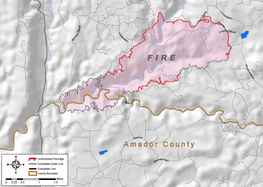
According to CAL FIRE the Sand Fire south of Placerville, California has not grown over the last 24 hours, with the size Monday morning remaining the same as on Sunday — 3,800 acres — while the containment has increased to 65 percent.
The number of structures burned has increased to 13 residences and 38 outbuildings. The resources assigned to the fire include 1,937 personnel, 196 engines, 51 hand crews, 30 dozers, and 52 water tenders.
California wildfires destroy 10 homes, 100s of people evacuated #SandFire #ElPortal http://t.co/y561pXHv6O pic.twitter.com/WFvGtW7T9l
— BBC News (World) (@BBCWorld) July 27, 2014
****
(UPDATE at 8 a.m. PDT, July 27, 2014)
CAL FIRE is releasing very little detailed information about the Sand Fire near Placerville, California, but a few minutes ago they announced that the revised size of the fire is 3,800 acres (down from 4,000) and said it is 35 percent contained. The fire has burned 10 residences and 7 outbuildings. The Sacramento Bee reported that Chris Anthony, A CAL FIRE spokesperson, said the fire was caused by a vehicle driving over dry vegetation. We will post an updated map of the fire when it becomes available.
****
(UPDATE at 9:30 p.m. PDT, July 26, 2014)
CAL FIRE reported at 8:15 p.m. that the Sand Fire south of Placerville, California has grown to 4,000 acres with 20 percent containment. There is no change in the number of structures burned; five residences and seven outbuildings. Resources working on the fire include 1,464 personnel, 149 engines, 45 hand crews, and 16 dozers.
#SandFire around 3pm from @HelwigWinery pic.twitter.com/PTmqq938vr — James Thorall (@JimThorall) July 27, 2014
****
(UPDATE at 7:43 p.m. PDT, July 26, 2014)
At 4:34 p.m. PDT CAL FIRE estimated the size of the Sand Fire south of Placerville at 3,000 acres with 20 percent containment.
****
(UPDATED at 4:25 p.m. PDT, July 26, 2014)
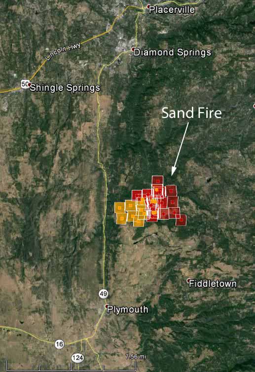
The red icons on the map of the Sand Fire above represent heat detected by a satellite at 2:14 p.m. PDT, July 26, 2015. It shows significant growth on the east side, compared to the map below from about nine hours earlier. The yellow icons represent heat from Friday. The fire is putting up a large column of smoke visible from Sacramento. Air Attack has requested more air tankers of any type; with the numerous structures that are threatened and the ongoing evacuations, he is not particular at this time which type shows up. Firefighters are burning around some of the structures ahead of the fire to reduce the fuel available when the fire reaches them. **** (Originally published at 2:29 p.m. PDT, July 26, 2014)
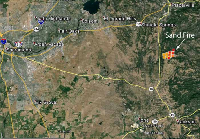
The Sand Fire, 10 miles south of Placerville, California, required the evacuation of several dozen homes a few hours after it started at 4:30 Friday afternoon. The spread of the fire slowed down by sunset under an aggressive aerial assault, but picked up again during the night. As this is written at 2 p.m. PDT, spot fires are helping the fire spread toward structures. Air Attack has ordered a total of seven air tankers, including one of the DC-10 Very Large Air Tankers. Five strike teams of engines, with five engines each, were ordered earlier. The fire is 14 miles north of Jackson and 33 miles east of Sacramento. (See the map of the Sand Fire above.) At least 13 structures have burned, including 4 residences. CAL FIRE reported at 8 a.m. on Saturday that the fire had blackened 1,300 acres and they were calling it 20 percent contained. It is being fought by 672 personnel, 53 engines, 21 hand crews, and 9 dozers. The weather on Saturday is making it difficult for firefighters, with a prediction of 98 to 103 degrees, a relative humidity of 8 to 13 percent, and winds gusting up to 18 mph out of the west in the afternoon.
#sandfire View from Story winery. pic.twitter.com/etTb2Vi1e2 — Kevin Oliver (@KCRAKevin) July 26, 2014
Followup on dozer rollover in California
The California Department of Forestry and Fire Protection has released a preliminary report on the July 6 dozer rollover on the Monticello Fire southeast of Lake Berryessa in Yolo County.
The summary:
****
“On July 6, 2014, at approximately 1320 hours, a CAL FIRE dozer was operating on Division M of the Monticello Incident. The dozer was working sidehill, constructing fire line in steep terrain. The dozer became unstable and rolled at least two times coming to rest on its tracks in a small drainage below. The operator sustained a head injury and a possible loss of consciousness.
Fire line personnel immediately responded to assist and treat the operator. A CAL FIRE helicopter performed a hoist rescue. The operator was transferred to a waiting medevac helicopter and was transported to a trauma center for evaluation. The operator was released from the hospital later that evening.”
Rattlesnake Fire, 61 years ago
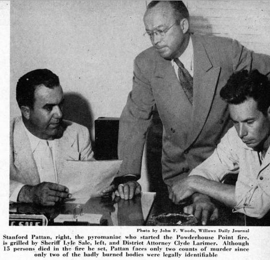 It was 61 years ago today that Stanford Pattan threw a match into some brush on the Mendocino National Forest in northern California. A matter of hours later 15 firefighters that were working on the Rattlesnake Fire were dead.
ForestHistory.org has a copy of a very interesting article that appeared in American Forests in 1953 describing Mr. Pattan, the struggles he faced, his earlier attempt to start a major fire that day, and his movements before and after he started the fire. The article includes one graphic photo.
Below is a brief summary of the incident from our Infamous Wildland Fires Around the World publication.
On July 9, 1953 a New Tribes Mission firefighting crew under the direction of U.S. Forest Service overhead was trapped by flames as they worked on a brush covered hillside in Powderhouse Canyon on the Mendocino National Forest. The crew was working on a spot fire in a narrow canyon covered with 40 year-old Chaparral brush. They had just completed construction of a hand line around their spot fire when a sudden wind shift caused another spot fire to flare-up. This other spot fire was located up-canyon from the crew. However, the unusually strong down-canyon wind pushed the uncontrolled spot fire toward the crew’s location. Within 30 minutes the fire had run more than a mile down canyon, catching the crew while they attempted to fight their way through the heavy brush to safety. Fifteen firefighters perished on the Rattlesnake Fire that day. Nine fellow crewmembers barely escaped.
California: Banner Fire east of Julian
(UPDATED at 7:12 a.m. PDT, July 4, 2014)
The Banner Fire has been mapped at 217 acres and the firefighters are calling it 40 percent contained. At CAL FIRE’s 7 a.m. update there were 331 personnel assigned, along with 28 engines, 10 hand crews, and 4 helicopters.
This will be our last report on the Banner Fire.
****
(UPDATED at 8:35 p.m. PDT, July 3, 2014)
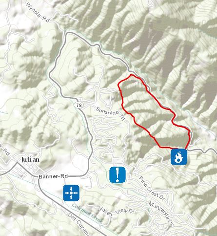
CAL FIRE reports that the Banner Fire just east of Julian, California is holding at 150 acres and they are calling it 15 percent contained. All evacuation orders have been lifted.
****
(Originally published at 5:27 PDT, July 3, 2014)
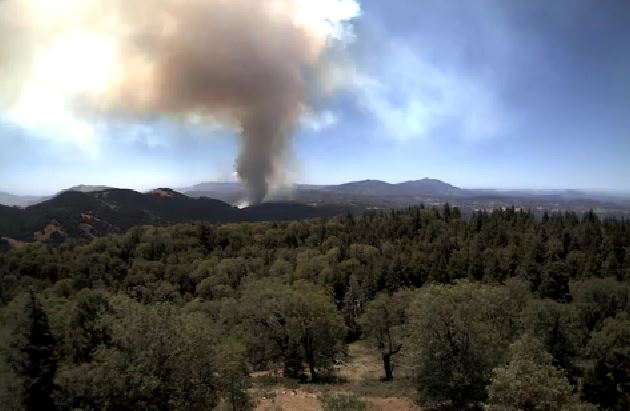
The Banner fire started near Banner Grade about a mile east of Julian, California at about 10:43 a.m. PDT, July 3, 2014. After a heavy attack by ground and air firefighters it burned 150 acres by 4:30 p.m.
Local media reported that two homes and an outbuilding burned.
By 5:20 p.m. local time a few units were being released and the radio traffic had subsided, which usually means they are beginning to obtain containment.
NBC in San Diego recorded some excellent video (below) showing drops by S-2T air tankers. It appeared that the camera operator and at least one resident got cooled off by the retardant, who was very pleased that she protected her camera.
The video below is a time lapse showing the smoke from the fire.
