Tag: California
California: Clover Fire southwest of Redding
(UPDATE at 2:39 p.m. PDT, September 12, 2013)
There has not been much change on the Clover fire southwest of Redding, California. The satellite has not detected any large areas of heat for a couple of days, but the reported size, at 7,993 acres Wednesday night, increased by about 900 acres. This may be a result of firefighters burning out vegetation to construct control lines. The Incident Commander claims 50 65 percent containment.
Fire and law enforcement officials have developed a repopulation plan, with expectations of allowing residents back into the area between September 12 and 14.
This will be our last update of the Clover Fire unless there is a major change in the status of the incident.
****
(UPDATE at 4:43 PDT, September 11, 2013)
On September 10, 2013 during the late evening hours, the Shasta County Sheriff’s Office located a deceased person inside the Clover Fire perimeter on Coal Pit Road in the community of Igo, California while conducting a welfare check. Next of kin was notified and the person has been identified as Brian Stanley Henry, 56. We send out our sincere condolences to the family of Mr. Henry.
Firefighters continued to work throughout Tuesday night and into Wednesday strengthening controls lines and mopping up hot spots around the fire perimeter. A Damage Inspection Team will continue to assess the properties today in the affected communities. Evacuations are still in effect.
CAL FIRE reports that the fire has burned 7,012 acres, is being fought by 1,346 personnel, and is 40 percent contained. The fire destroyed 30 residences and 50 outbuildings, and damaged an additional 30 residences.
****
(UPDATED at 8:02 a.m. PDT, September 10, 2013)
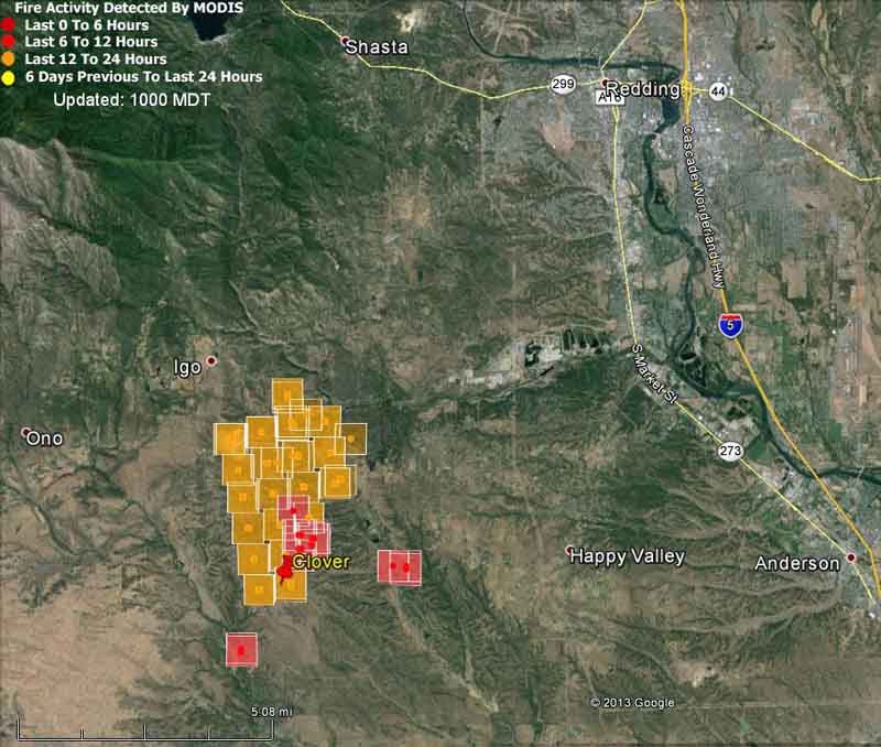
CAL FIRE reports that the Clover fire 6 miles southwest of the outskirts of Redding, California has destroyed 80 structures and damaged an additional 30. It continues to move toward the southwest. In less than 24 hours it has blackened 7,400 acres and has required the evacuation of the Happy Valley, Igo, and Cottonwood areas. The incident commander is calling it 40 percent contained.
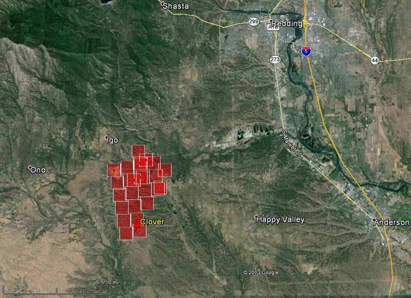
A map of the fire is below shows heat detected by a satellite. If the fire is burning in light vegetation in some areas, such as grass, the fire may cool in those areas before the next pass of the satellite, resulting in no large areas of heat being detected at that time. This may account for the gaps shown in the heat map. Or, the firefighters may be burning out vegetation ahead of the fire.

CAL FIRE’s Team 5, a Type 1 Incident Management Team, is scheduled to assume command of the fire at 3 p.m. Tuesday.
Resources assigned to the fire include 1,129 personnel, 107 engines, 36 hand crews, 6 air tankers, and 18 water tenders.
Weather
Overnight the wind slowed considerably and the relative humidity increased, allowing firefighters to make some progress. The forecast for the fire area for Tuesday calls for 101 degrees, a relative humidity of 13 percent, clear skies, and north winds of 6 mph changing to come out of the south after noon at about the same speed.
EVACUATIONS
Residents have been advised to evacuate from the following areas:
- Clear Creek Road and Cloverdale Road
- Everything southwest to Gas Point Road and Small Farms and Marsha Way
- Gas Point Road and Happy Valley Road
- Small Farms track south to Black Pine Road
- Cloverdale from Clear Creek to Oak
- Oak to Palm
****
(UPDATED at 5:05 p.m. MDT, September 9, 2013)

The fire placed a large order for additional resources, including over a dozen strike teams of engines (five engines per strike team) and five strike teams of hand crews (two crews per strike team).
You can listen to some of the radio traffic here.
****
(Originally published at 4 p.m. PDT, September 9, 2013)
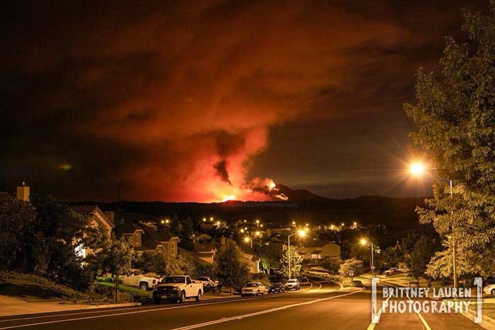
A fire that has only been burning for about three hours has already blackened approximately 1,500 2,200 acres in northern California and is causing evacuations. The Clover Fire was reported at 12:32 p.m. PDT today, Monday, and has spread to about 2 miles south of Igo, 6 miles southwest of the outskirts of Redding, and 10 miles west of Anderson (see the above map).
The fire started south of Clear Creek Road and east of Gas Point Road, but by 3:30 p.m. Monday had crossed Gas Point Road.
Evacuations are occurring in the following areas: Small Farms Rd., Clear Creek Rd., Cloverdale Rd. southwest to Gas Point Rd., Cloverdale Rd. from Clear Creek Rd. to Oak, Oak to Palm, Small Farm Track south to Black Pine Rd.
The two DC-10 Very Large Air Tankers had been ordered for the Morgan Fire east of San Francisco, but shortly after they arrived at that fire they were diverted to this new Clover Fire.
Weather
Strong winds and low relative humidities are challenging firefighters. The weather station at the Redding Airport 11 miles east of the fire Monday afternoon recorded 17 mph north and northwest winds gusting at 27 to 30 mph along with a relative humidity of 7 percent. The temperature at the airport reached 15 degrees. The forecast for the fire area for the next two days is slightly more favorable, calling for temperatures in the mid to high 90s, winds at 3 to 6 mph (north on Tuesday and south on Wednesday), humidities of 14 to 22 percent, virtually no chance of rain, and little if any cloud cover.
California: Morgan fire
(UPDATED at 8:30 a.m. PDT, September 10, 2013)
The spread of the Morgan Fire in Mt. Diablo State Park 18 miles east of Berkeley, California slowed late in the day on Monday. More accurate mapping resulted in a decrease in acreage, from 3,718 to 3,243 acres by Tuesday morning. The incident commander is calling it 45 percent contained, up from 20 percent on Monday.
KTVU has an interesting timelapse video of the fire.
****

(UPDATED at 4:57 p.m. PDT, September 9, 2013)
The Morgan Fire east of the San Francisco Bay area has grown to 3,718 acres, and the Incident Commander is calling it 20 percent contained.
****
(Originally published at 12:33 p.m. PDT, September 9, 2013)
The Morgan Fire is burning in Mt. Diablo State Park 18 miles east of Berkeley, California (see the map below). It started Sunday at 1 p.m. and burned actively all night. The fire is currently threatening PG&E electrical transmission lines, communications infrastructure on Mt. Diablo, and historical buildings at the summit of Mt. Diablo. At 11:30 a.m. on Monday CAL FIRE said it had burned 1,500 acres.

Mandatory evacuations have been ordered for Oak Hill Lane, Curry Canyon, Curry Lane, Curry Point, Trail Ride Road, East Trail Road, Russelman Park Road, Upper Trail Road and Lower Trail Road.
The fire is being fought by 705 personnel, 85 engines, 30 hand crews, and 11 dozers.

These sites occasionally have live video feeds of the fire: KTVU, Dropcam, ABC7news, and NBC Bay Area. And there’s a web cam that needs to be refreshed to see the latest images: Mt. Diablo Cam.
After a fire, before a flood: NASA’s Landsat directs restoration to at-risk areas
While the 138,000-acre Silver Fire in New Mexico still smoldered, forest restoration specialists were on the job in August. They analyzed maps created using Landsat satellite data to determine where the burn destroyed vegetation and exposed soil – and where to focus emergency restoration efforts.

“The map looked like a big red blob,” said Penny Luehring, the U.S. Forest Service’s Burned Area Emergency Response and watershed improvement program leader, based in Albuquerque, N.M.
Red means high-severity fire, she explained – and the red areas were concentrated in a watershed drainage that fed communities west of Las Cruces, N.M. So crews got to work. The Burned Area Emergency Response, or BAER, teams are designed to go in as soon as the flames die down to help protect reservoirs, watersheds and infrastructure from post-fire floods and erosion. And Landsat satellites, built by NASA and operated by the U.S. Geological Survey, help direct the crews to those forest areas needing attention.
As a wildfire starts to die down, fire managers like Luehring can contact the Forest Service’s Remote Sensing Applications Center in Salt Lake City to request maps that identify the high, moderate and low severity burns. When that call comes in, remote sensing specialist Carl Albury finds satellite imagery of the burned forest both pre- and post-fire.
In Landsat images, he looks at two of the 11 spectral bands – the near-infrared band and a short-wave infrared band.
“The near infrared reflects well from healthy vegetation, and the short-wave infrared bands reflect well from exposed ground,” Albury said. “By comparing the normalized ratio of the near- and shortwave-infrared bands in the pre-fire image to the post-fire image, we can estimate the burn severity.”
Continue reading “After a fire, before a flood: NASA’s Landsat directs restoration to at-risk areas”
Lessons Learned Review: Rhabdomyolysis leading to heat stroke

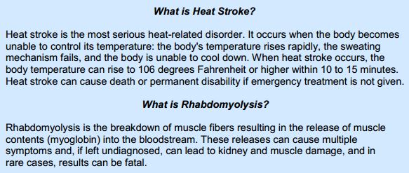
A Lessons Learned Review (LLR) for an unusual but severe injury has been released. A firefighter working for the National Park Service at Sequoia and Kings Canyon National Parks in California developed rhabdomyolysis (rhabdo) during his first week of work this season, probably after his first day which included very strenuous physical training. Then four days later, on June 27, 2013, he suffered from heat stroke during a training run. Recent research indicates that muscle damaging exercises can increase heat strain during subsequent exercise.
The firefighter was treated by NPS medics at the scene and then transported by a California Highway Patrol helicopter with a paramedic on board. He arrived at a Level I trauma center within one hour and thirty three minutes of his collapse while running. The doctor at the hospital told his parents that he was “…a profoundly sick young man, who may not make it.” He was hospitalized for two weeks and underwent kidney dialysis three times a week for seven weeks; reduced to once a week at the time the report was written, and was projected to make a full recovery. He hopes to return to light duty work, but cannot do so until he is finished with kidney dialysis treatments.
An excerpt from the report:
The LLR Team would like to commend the EMS responders, both from the NPS and the CHP, for their quick- thinking and actions. The LLR Team is certain that if these employees had not done so, [the firefighter’s] injury would have proved fatal.
The report, written by a four-person team that included an Exercise Physiologist with a PH.D., is very well written. It includes numerous recommendations for sustaining good practices as well as suggestions for improving the handling of rhambdo and other serious injuries, both locally and nationally.
All firefighters should read this Lessons Learned Review.
 More information and heat illness and its prevention.
Other articles at Wildfire Today about rhabdomyolysis.
The wildfire situation in California, and nationally
Two videos were released today. The first one is from the National Interagency Fire Center and summarizes the 2013 fire season to date. The second is from CAL FIRE and covers the fires in California over the last week.


