Ponderosa Fire update, August 22, 2012

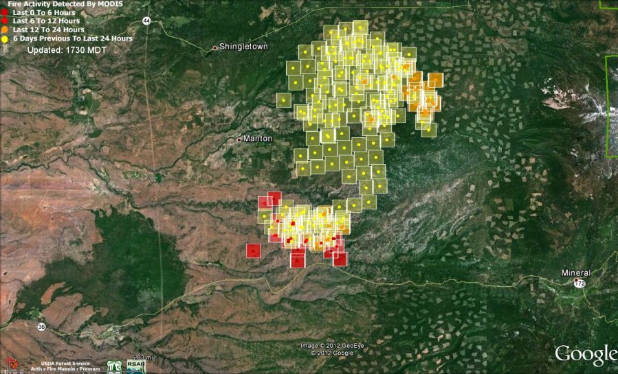
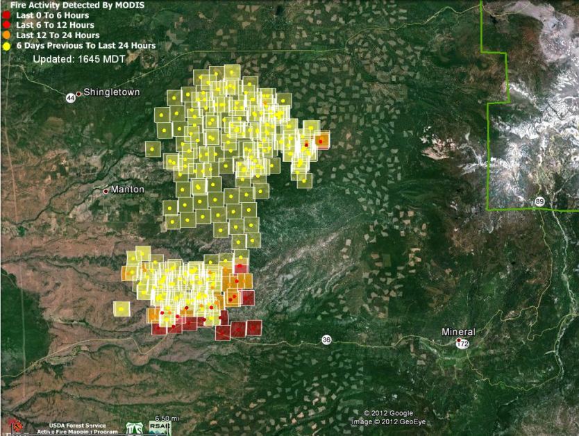
Map of Ponderosa Fire, 1:18 pm PT, August 22, 2012
Map of Ponderosa Fire, 1:18 pm PT, August 22, 2012. MODIS/Google (click to enlarge)

The Ponderosa Fire, 22 miles northeast of Red Bluff, California, has grown to over 24,000 acres according to CAL FIRE in their 2:30 p.m. update today. The number of structures burned remains at 50. CAL FIRE has not announced the location of the structures.

The map of the fire shows heat detected by a satellite at 1:18 p.m. PT time today. There are some heat signatures that appear indicate that the fire crossed Highway 36 on the south side of the fire, but this satellite data can have errors of up to a mile. Most of the current heat, as shown by the red squares, was on the south and southeast sides.

According to CAL FIRE at 2:30 p.m. today, evacuations for the following areas were in effect near Manton, Shingletown, Viola, and Mineral:

  • Canyon View Loop north of Hwy 36.
  • Forward Mill Rd from Rock Creek Rd to Forward Camp Rd
  • Rock Creek Rd from Manton Rd to Long Hay Flat Rd
  • Forward Rd at Yuen-Veritas Ln to the C Line
  • Southside of Highway 44 from S-Line and A-Line including S-Line, P-Line, Long Hay Flat Rd, Rock Creek Rd & Viola Rd
  • Evacuation Warning – Hwy 36 at Oasis Springs Ranch Rd to Lassen Lodge on both sides of the Highway including Ponderosa Sky Ranch and Lassen Lodge.
  • Evacuation Warning – Hwy 36 from Lassen Lodge east to, and including, the community of Mineral.

At 12:30 p.m. Wednesday many of the evacuations for the Shingletown, Lake McCumber area and roads north of Hwy 44 were lifted.

 

Firefighters injured by air tanker drop

CAL FIRE has released a preliminary report about two firefighters being treated at a hospital after being hit by an air tanker drop on the Buck fire in Riverside County, August 14, 2012. Here is the text from their “Blue Sheet”:

==============================================================

SYNOPSIS

The following is a Preliminary Summary Report of an incident that occurred due to an air tanker drop on a wildland fire incident, resulting in minor injuries to two crewmembers.

NARRATIVE

While assigned to perimeter control / structure defense in the initial attack phase of an extended attack fire, a CAL FIRE/Riverside County Fire Department type III fire engine and two of the three crewmembers, were struck by retardant dropped from a CAL FIRE air tanker. At the time of incident, the crewmembers were scouting on foot to determine the best access to their assignment. As they turned to walk back to the engine, the Fire Apparatus Engineer and one Firefighter were struck from behind and knocked to the ground by the force of the retardant released by a passing air tanker. The Crewmembers involved did not see or hear the air tanker until moments prior to impact.

The Fire Apparatus Engineer and both firefighters regrouped and engaged in the assignment. Approximately one hour later, the Fire Apparatus Engineer noticed the involved Firefighter appeared disoriented and his face appeared swollen. The Fire Apparatus Engineer requested and received medical assistance. Upon evaluation, the Paramedic Engine Company assigned to the Division made the decision to transport via ambulance both the Fire Apparatus Engineer and the Firefighter to the hospital for further evaluation. Both were treated and released within hours of the incident.

RECOMMENDATIONS FOR IMMEDIATE REVIEW

• All personnel will maintain Situational Awareness at all times – “Look Up, Look Down, and Look All Around!”

• Communication and Coordination is imperative between ground and air resources to ensure safe tactics and minimize potential injuries. Per CAL FIRE Handbook 7015.3, important frequencies must be scanned and monitored by all resources. Scan only frequencies that are necessary to the assignment. Monitor important frequencies constantly

• Air Tanker Pilots and ATGS Personnel should review CAL FIRE Handbook 8364.6.3 “Retardant (or other suppressant) releases will be made at a high enough altitude where all forward motion of the fluid stops prior to impact with the ground. In no case will retardant be dropped lower than 150 feet above the top of vegetation.”

• Personnel should review CAL FIRE Handbook Section 4306.18 – “How to assume the safe position for an Air Tanker Retardant Drop.

CAL FIRE reports 43 more homes burned in Ponderosa Fire

Map of Ponderosa Fire, 2:15 p.m. PT, August 21, 2012
Map of Ponderosa Fire, showing heat detected by a satellite at 2:15 p.m. PT, August 21, 2012. MODIS/Google (click to enlarge)

(Updated at 6:48 p.m PT, August 21, 2012)

The Ponderosa Fire, 22 miles northeast of Red Bluff, California, has grown to 21,506 acres as of Tuesday afternoon. At 6:15 p.m today CAL FIRE increased the number of structures reported as destroyed to 50, which is 43 more than they reported this morning and yesterday. Another 200 structures remain threatened. The fire is burning in a mix of grass, brush, and heavy timber and is being called 40 percent contained.

The above map shows that as of 2:15 p.m. PT today most of the heat detected by a satellite was on the south side of the fire near Highway 36. Keep in mind that the locations depicted were identified from hundreds of miles above the earth, so there can be errors by up to a mile or so.

The fire continues to burn to the east and south in the Battle Creek Drainage.

The areas that are evacuated were confirmed by CAL FIRE for the following areas in Manton, Shingletown & Viola:

  • Forward Rd at Graham to the C Line
  • Forward Mill Rd from Rock Creek Rd to Forward Camp Rd
  • Rock Creek Rd from Manton Rd to Long Hay Flat Rd
  • All of Long Hay Flat Rd and Woodcutter Way
  • Southside of Highway 44 from Viola to Brush Oak
  • Northside of Hwy 44 from Viola to Alward
  • Hazen Rd area and South Power House Rd south of Manton
  • Hwy 44 at Brush Oak east to and including Viola, Plateau Pines, Starlight Pines and Lake McCumber area
  • South side of Hwy 44 from Viola to Brush Oak and on the north side of Hwy 44 from Viola to Alward

Evacuation warnings have been issued for Hwy 36 from Ponderosa Sky Ranch to Lassen Lodge communities.

Resources assigned to the fire include 2,133 personnel, 278 engines, 38 hand crews, 11 helicopters, and 53 dozers

“TurtleSloth” uploaded this video yesterday showing of one of the DC-10 very large air tankers dropping near Highway 36 on the Ponderosa fire.


Ponderosa fire near Manton, CA burns 7 homes, threatens 3,500

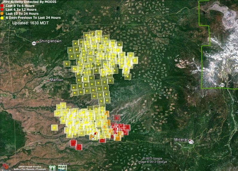
Map of Ponderosa Fire, 12:50 p.m PT, August 19, 2012
Map of Ponderosa Fire, 1:32 p.m PT, August 20, 2012 (click to enlarge)

The Ponderosa fire 22 miles northeast of Red Bluff, California is causing evacuations of thousands of residents near the community of Mandan. According to CAL FIRE 15,000 acres and seven homes have burned since the fire started at around noon on Saturday.

The map above shows heat from the fire that was detected by a satellite Monday afternoon at 1:32 PT.  The dark red squares indicate heat that was detected within the previous six hours.

At 7 a.m. Monday, CAL FIRE announced the following evacuations in the Manton, Shingletown & Viola areas:

  • Forward Rd at Graham to the C Line
  • Forward Mill Rd from Rock Creek Rd to Forward Camp Rd
  • Rock Creek Rd from Manton Rd to Long Hay Flat Rd
  • All of Long Hay Flat Rd and Woodcutter Way
  • Southside of Highway 44 from Viola to Brush Oak
  • Northside of Hwy 44 from Viola to Alward
  • Hazen Rd area and South Power House Rd south of Manton
  • Hwy 44 at Brush Oak east to and including Viola, Plateau Pines, Starlight Pines and Lake McCumber area
  • South side of Hwy 44 from Viola to Brush Oak and on the north side of Hwy 44 from Viola to Alward.

In addition, CAL FIRE warned people in the area of Highway 36 at Oasis Springs Road to Lassen Lodge on both sides of the highway, which includes Ponderosa Sky Ranch, Canyon View Loop area and Lassen Lodge, of a potential threat to life and property. An evacuation warning considers the probability that an area will be affected and prepares people for a potential evacuation order.

The weather through Tuesday will not be extreme, but the wind direction will shift several times pushing the fire in various directions, challenging firefighters to remain safe. Monday night the wind will be out of the southwest at 6-10 mph, shifting to the southeast and then from the east Tuesday morning, and finally changing to a 13 mph southwest wind by noon on Tuesday.

Inmate firefighter dies after falling ill on California fire

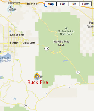
The 2,681-acre Buck Fire south of Hemet, California, was fully contained on Friday morning, and the North County Times reported that an inmate firefighter died yesterday after he became ill on the fire.

The California Department of Corrections and Rehabilitation (CDCR) and Cal Fire are investigating the illness and subsequent death of 44-year-old Jimmy Randolph, who died at a hospital in Palm Springs with his family at his bedside. The cause of death will be announced after an autopsy is completed.

(UPDATED July 13, 2017. Mr. Randolf died in a hospital August 19, 2012 seven hours after he was found unresponsive where he was sleeping at the fire. The cause of death was listed as anoxic encephalopathy combined with complications of heat stroke.)

Buck Fire location

Fenner Canyon Conservation Camp on the Angeles National Forest houses minimum-security inmates and is operated jointly by CDCR and Cal Fire.

The Buck Fire also had a microburst rip through the ICP early Thursday, with hard rain and hail and 60 mph gusts that sent tents and much of the camp skittering across the ground. The fire, ignited by lightning last Tuesday, was also plagued with injuries; according to the Desert Sun, one firefighter was taken to a hospital for minor injuries. Three other firefighters incurred minor injuries, along with two civilians, one of whom suffered severe third-degree burns to his legs.

Riverside County Sheriff’s deputies are investigating a marijuana patch discovered in the area. According to the L.A. Times, firefighters encountered two men trying to protect the small grove of plants.

This fire had more than its share of weirdness. The Desert Sun also reported that a 59-year-old local man was charged with driving over a fire captain’s foot on Tuesday afternoon. Gregory Lance Good is being held in lieu of $30,000 bail on charges of assault with a deadly weapon and interfering with a firefighter in the line of duty. He was arraigned in Riverside County Superior Court and entered a “not guilty” plea.

Ponderosa fire forces evacuations near Manton, California. Fire in Lassen NP continues to burn.

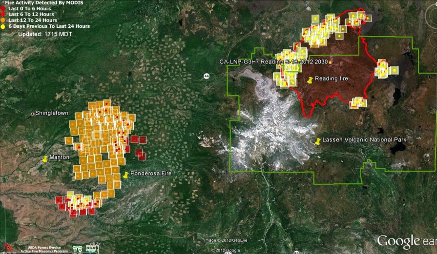
Map of Ponderosa and Reading fires 150 pm August 19, 2012
Map showing heat detected by a satellite on the Ponderosa and Reading fires, 1:50 p.m., August 19, 2012. MODIS/Google. (click to enlarge)

The Ponderosa fire just east of the communities of Manton and Shingletown in northern California is forcing the evacuation of many residents in the area 25 miles northeast of Red Bluff. CAL FIRE reports that the fire has burned 12,000 acres and is zero percent contained since it started at about 11:30 on Saturday. At least 3,000 structures are threatened and four have already been destroyed. As of Sunday afternoon 974 personnel, 105 engines, 31 dozers, and 22 hand crews were assigned to the fire.

As you can see in the map above, the Ponderosa Fire is only 12 miles from the Reading  fire in Lassen Volcanic National Park. That fire was not initially suppressed by the National Park Service when it started on July 23, but has now burned almost 28,000 acres and is only 51 percent contained. The estimated costs to the taxpayers for the Reading fire to date is $13 million. Today 795 people were working on the fire