California: Freeway fire report released

Map, Freeway Complex
Map, Freeway Complex, from OCFA AAR.

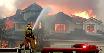
The Orange County Fire Authority has released a 128-page report (large 8Mb file) about the devasting Freeway Fire that started November 15, 2008 in southern California and destroyed 203 homes in Orange County, including the communities of Yorba Linda and Anaheim Hills.

The Orange County Register has an excellent article on the report, but here are some excerpts outlining some of the key issues from their account:

=============

The major recommendations include improving radio communications, training crews in battling house fires near wildland areas, working with local water agencies to identify and rectify weaknesses in water systems, and developing a rapid-mobilization plan in large-scale emergency situations.

Yorba Linda fire
Firefighters try to suppress a fire in a structure in Yorba Linda on the Freeway fire in November, 2008.

Nearly 18 months after the Santiago fire raced through Orange County’s canyons, tight economic times have forced the Fire Authority to postpone several major recommendations after that fire, including replacing its part-time hand crew with a full-time crew and adding a fourth firefighter to wildland engines to meet federal standards. The same recommendations were echoed in the Freeway Complex review.

The plan was to pinch off the fire early. But hundreds of gallons of water destined to be dropped by helicopters on the fire had to be diverted and dropped on a Corona fire engine crew that had been overrun by flames after going off-road to try to fight the flames. The Corona crew’s decision placed them in a “dangerous position,” between the fast-moving fire and unburned brush, the report said. The crew was saved, but flames raced west toward Yorba Linda, throwing embers more than a mile in front of the fire.

Off-duty Fire Authority crews were mounting their own defenses, hijacking three engines and heading to the firefight, creating serious safety and accountability issues. Command staff scrambling for extra engines to send to the firefight spent up to 12 hours trying to find the maverick engines, the report said.  “These firefighters are heroes,” Fire Authority union President Joe Kerr said. “These firefighters came in off-duty to try to do everything they could to save homes. A lot of homes were saved because of them. You’re not going to find more dedication than that.”

“We take crew accountability very seriously,” Concepcion said. “We want to make sure this never happens again.”  The involved firefighters have been interviewed but were not disciplined, Kerr said.

Two strike teams – a total of 10 fire engines – were ordered by Battalion Chief Rick Reeder to stage at Station 53 on East La Palma in Yorba Linda to get ahead of the fire. “In my mind, what was burning in Corona was already done,” Reeder said. “It was not the piece to worry about.”

Strike team leaders ignored Reeder’s order, self-dispatching instead to Corona, the report said. With the original order unfilled, strike teams did not arrive into Yorba Linda until 11 a.m. – nearly 2 hours later. The first Yorba Linda house was already burning. Command officers have a “certain amount of latitude,” Concepcion said. “They must have thought there was something more pressing in Corona,” he said.

Fire stations were emptied to fight the Laguna fire in 1993, but entire OCFA battalions were left fully staffed during the Freeway Complex fire, officials said. “We had two fires burning close to each other, and we didn’t know what caused them,” Concepcion said. Extra strike teams were ordered from other counties, but it took time for them to arrive.

Multiple new fires in southern California

More fires have started in southern California and are being pushed by the Santa Ana winds. We will post maps of the fires as they are available.

“Freeway” fire near Corona and Yorba Linda

UPDATE @ 10:07 p.m. Saturday

The Freeway (or Corona or Yorba Linda) fire and the Landfill (or Brea) fire are still two separate fires and have not burned together yet. However, firefighters are confident that they will merge and it could happen as early as dawn on Sunday. If they merge at Carbon Canyon Road (Highway 142) it will be a real challenge for firefighers to protect the homes in that area if they have fires approaching from two different directions.

UPDATE @ 8:13 p.m. Saturday

Below is a screen capture from infrared imagery taken by a U.S. Forest Service research aircraft at 2:30 p.m. today. the lighter brown areas are burned, and the red is active fire. You can view the original imagery, and zoom and pan, by clicking HERE.

At that site you can then click on “Local Area Map for the Freeway Fire (Google Maps) with thermal overlay” which will overlay the thermal map over a Google street map. Be patient, it takes a while to load. Then you can toggle on or off the overlay by checking the box on the left side (because the overlay obscures the Google map).


The last size reported on the fire late this afternoon at 9:00 p.m. was that it is 2,000 5,870 acres and 5% contained.

Structures lost on the Freeway fire, according to a spokesman on the fire:

  • 14 structures in Corona
  • 10 in Anaheim Hills
  • One 40-unit apartment complex in Anaheim Hills
  • 30 structures in Yorba Linda

More information is available about earlier report about the two firefighters that were injured, from Jon Dorsey of the CalFire Southern Operations Center.

At approximately 10:00 hrs, 1 Fire Captain, 1 Engineer and 2 Firefighters from Corona City Fire were injured while performing direct attack on the fire in the Green River Community. They were overcome by fire and all four suffered minor smoke inhalation injuries, with two receiving minor burns. Two were treated and released from Arrowhead Regional Medical Center, while the others were sent to Corona Regional Medical Center, where one remains at this time.

WEATHER:
The high wind warning has been canceled, but the red flag warning will continue until 4 p.m. Sunday. Temperatures will remain in the 80s until Wednesday, when it should be cooler.

UPDATE @ 4:42 p.m. Saturday

Below is a map showing thermal imagery from a satellite. The red areas are the two fires west of Corona in the Yorba Linda, Brea, and Anaheim areas. The western most one is the Brea or Dump fire. The eastern most one is the Freeway fire. It appears that this imagery is from late this afternoon. The Brea fire seems to have crossed the 57 freeway, and we already knew the Freeway fire was well established south of the 91.

Click on the map to see a larger version.


————————————

UPDATE @ 2:27 p.m. Saturday

A 250-unit apartment complex south of the 91 freeway near Santa Ana Canyon Road and some single family dwellings in the same area are fully involved.

Here is an updated map that shows the approximate location of the Freeway fire west of Corona. Click on it to see a larger version.

————————————-

UPDATE @ 1:45 p.m. Saturday

The fire crossed the 91 freeway in two places and 3,100 homes in the Anaheim Hills area (south of 91 and west of 241) are under an evacuation order.

—————————
11:40 a.m. Saturday

The DC-10 air tanker making a drop on the Freeway fire near Corona. It dropped continuously for 10 seconds, much longer than smaller air tankers. Oddly, there was a smaller twin-engine plane flying closely on the side of the DC-10, unlike lead planes which fly some distance ahead of air tankers.

Here is a map that shows the approximate location of the Freeway fire. Click on the map to see a larger version.

This fire, named Freeway, started late this morning and as of 11:40 a.m. PT has already burned 800-1,000 acres and has damaged or destroyed 12 homes. It is on the north side of the 91 freeway near Green River Road. It has burned into Yorba Linda where evacuations are in progress and some homes burned near Merryweather Circle.

An engine crew was burned over according to LA channel 7. Two firefighters have minor injuries and were treated at a hospital.

Fire in Brea (“Landfill” fire)

UPDATE @ 3:40 p.m. PT Saturday

The fire has burned quite a distance to the west and jumped the 57 freeway for a while but firefighters picked up that portion that crossed the freeway. A reporter from Fox 11 is at the fire edge on Wildcat Way just north of W. Lambert Road in Yorba Linda. HERE is a link to a map of that location.

Farther to the east at Hidden Hills Rd. and Greencrest Dr. many mega-mansions are burning to the ground. The situation is complicated by the fact that there is no water pressure at all in the water system. Firefighters are emptying the tanks in the engines, then leaving the area to get water, then returning again.

The director of the Yorba Linda Water District said that there are multiple pumping stations that pump water into some of the higher elevations that are burning now, and at least one of the pump stations burned. They are investigating the possibility of bringing in a pump to replace the one that burned. So… the fire suppression infrastructure works fine… until there is a fire. Just a idea: Make the pumping stations resistant to fire.

———————————
11:40 a.m. Saturday

This is a new fire a mile or two or three west of the Freeway fire. It is smaller than the Freeway fire, but no additional information is available. It may have been a spot from the Freeway fire.

BTU Complex: 50 homes burn in Concow

At least 50 homes burned Tuesday in the city of Concow, California as the BTU (or Butte) Lightning Complex swept through communities 20 miles east of Chico. The entire east half of the city of Paradise, a city of 26,000, is under evacuation orders, and some areas of Magalia have also been evacuated.

If the weather forecast is accurate, Paradise and Magalia are under a severe threat from the fire. Firefighters hope to stop the fire at the West Branch of the Feather River just east of the city.

This is the third time in the last few weeks that Paradise has had a bulls eye painted on it by fires heading in their direction.

HERE is a link to a very interesting map of the fire in the area made by the newspaper in Chico, the Chico Enterprise Record. This is an amazing use of Google Maps. You might call it groundbreaking. There is a ton of information there—I hope the data is accurate. Click on the icons on the map to get details.

Record high temperatures as high as 115 in the valley on Tuesday contributed to the extreme fire behavior. Foothill temperatures were expected to be in the 90s on Tuesday.

The Weather forecast for Paradisc, CA: (note that the maximum relative humidities at night only go up to 30% and 26%)

Tuesday night: Areas of smoke. Clear, with a low around 79. Northeast wind between 10 and 15 mph, with gusts as high as 18 mph. RH 30%.

Wednesday: Areas of smoke. Sunny and hot, with a high near 110. North northwest wind between 5 and 10 mph. RH 10%.

Wednesday Night: Areas of smoke. Clear, with a low around 77. North wind between 7 and 13 mph. RH 26%

Thursday: Areas of smoke. Sunny and hot, with a high near 108. Northeast wind 6 to 8 mph becoming west. RH 11%.

Martin Mars reloads

Martin Mars scooping
Hawaii Martin Mars scooping water at Lake Shasta.

I wonder what kind of wake the Martin Mars creates when it skims along a 3-mile stretch of Lake Shasta filling its 7,200 gallon tank at 80 miles per hour? It probably makes the lake a little choppy for the water skiers for a few minutes.

Always film posterOn Friday, it did this 20 times, reloading about every 25 minutes, dropping the water on the nearby 16,700-acre Motion fire. That is a damn good turn around time for an air tanker. The pilots have the option of dropping plain water on the fires, or mixing class A foam or fire retardant gel into the water.

Do you remember the opening sequence in the 1989 movie, the Steven Spielberg production with Richard Dreyfuss, Holly Hunter, and John Goodman that is centered around air tanker pilots? Turn up the sound when you play the 55-second clip below….it’s more fun that way.

One of the lines in the movie is still food for thought for firefighters.  John Goodman said to Richard Dreyfuss:

Pete, there ain’t no war here… And this is why you’re not exactly a hero for taking these chances you take. You’re more of what I would call a dickhead.

Some trivia about the movie, from Wikipedia:

The movie is set in the Kootenai National Forest in Montana, with some scenes filmed in and around Libby, Montana. Some 500 people from Libby were recruited for the movie as extras to act as wildland firefighters.

In the opening scenes the forest fires were created by Pathfinder Helicopter Inc.. They were hired by the Forest Service to burn some clearcuts near Libby that were filmed for the movie. The helicopter Pilot was Steve Tolle and the Ground Crew Manager was Jim Leighty.

The Libby airport was used to double as the Forest Service Headquarters in the movie.

California: Two dozer rollovers

Two dozer operators rolled their dozers on Tuesday. One was wearing a seat belt and one was not.

A private contractor assigned to the Cold fire in Plumas County suffered a fractured skull, a dislocated shoulder and injuries to one ear when the bulldozer he was operating rolled over, said Dave Olson, a fire information officer for the Canyon Complex of fires on Plumas National Forest.

The employee of Oilar Agricultural Services, based in MacArthur, was flown to Enloe Medical Facility in Chico, where he was in stable condition Wednesday with no life-threatening injuries, Olson said.

In Siskiyou County, a contract operator was digging a fire line between the Alps Complex fire and the Ironside fire when his bulldozer rolled 80 feet down an embankment, said Alexis West, a fire information officer on the complex of fires burning on Shasta-Trinity National Forest.

The operator was wearing a seat belt, which probably saved his life, West said. He was taken to a Redding hospital, where he was treated for arm and shoulder injuries.

He was conscious and alert in Mercy Medical Center on Wednesday morning, West said.

From the Sacramento Bee