The blaze burned more than 36,000 acres in Giant Sequoia National Monument and Sequoia National Forest in California
Booking photos by Tulare County District Attorney’s Office
Four people were sentenced for starting the Pier Fire that burned more than 36,000 acres east of Springville, California in Giant Sequoia National Monument and Sequoia National Forest in August and September of 2017.
On Monday Isiac Renteria, 23, Richard Renteria, 25, Osvaldo Esparza-Guerrero, and Breana Ojeda, 24, each pleaded guilty to felony charges related to arson. They received sentences of 9 years suspended prison with credit for serving 3 years in custody, except for Ojeca who received a sentence of 3 years, 4 months of suspended prison.
Pier Fire progression map. IMT.
All four were ordered to pay $40 million in restitution, which was the cost of damages and suppression of the Pier Fire. There will be a restitution hearing on October 6.
Investigators determined that they burned a stolen vehicle, which ignited the wildfire.
Pier Fire. Photo by Fire Behavior Assessment Team.
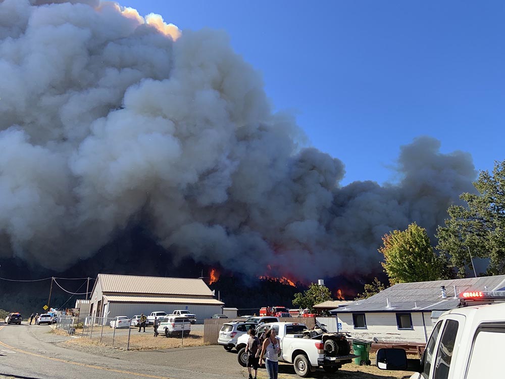
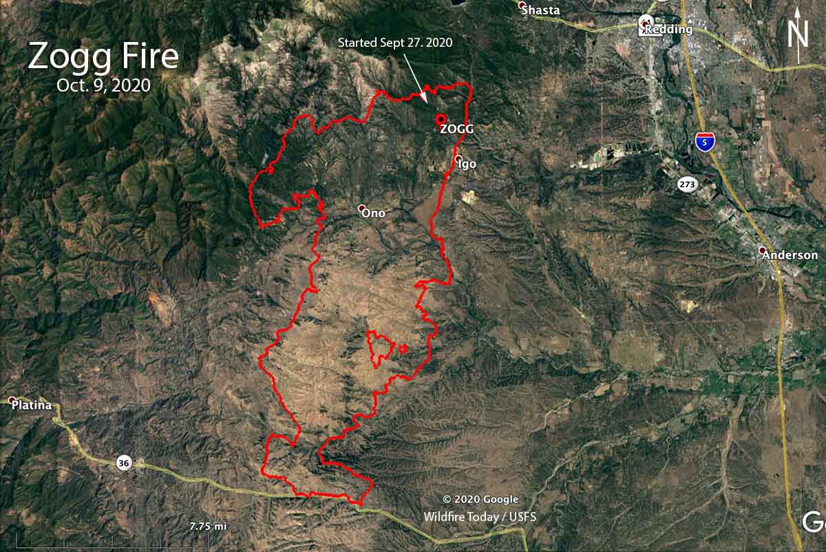
In March investigators with CAL FIRE determined that the Zogg Fire which burned 56,338 acres, destroyed 204 structures, and caused four civilian fatalities, was caused by a tree contacting a power line operated by Pacific Gas and Electric (PG&E). On Friday the company was charged with manslaughter and other charges.
Shasta County District Attorney Stephanie Bridgett announced the 31 charges, including 11 felonies, against PG&E, saying it failed to perform its legal duties and that its “failure was reckless and criminally negligent, and it resulted in the death of four people.”
If the utility is convicted of manslaughter, the punishment would be a fine for each person killed in the Zogg Fire last year southwest of Redding, California.
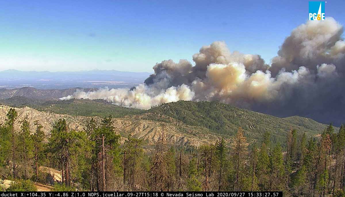
Zogg Fire soon after it started, looking east from Ducket at 3:32 p.m. PDT Sept. 27, 2020. AlertWildfire.
Last year PG&E pleaded guilty to 84 counts of involuntary manslaughter for starting the Camp Fire which destroyed most of the town of Paradise and became the deadliest wildfire in the U.S. in more than a century.
The company has admitted that their equipment may have ignited the Dixie Fire which has burned more than 600 residences and 963,000 acres near Susanville, California. At least two firefighters died of COVID-19 while assigned to the fire.
A mapping flight Monday night determined the blaze had burned 8,559 acres
8:40 a.m. PDT Sept. 27, 2021
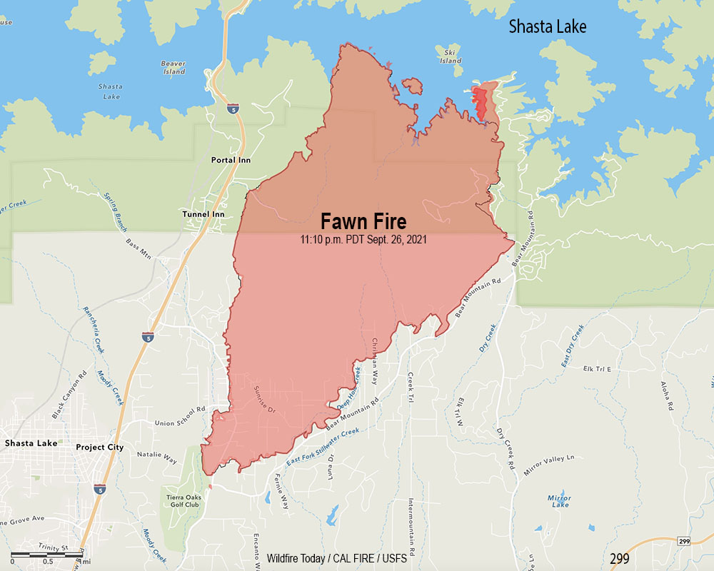
Fawn Fire map. The outer red line was the perimeter mapped by a fixed wing flight at 11:10 p.m. Sept. 26, 2021. The blackish/red line was the perimeter about 26 hours before. The dark red area represents intense heat when the fire was mapped.
The incident management team on the Fawn Fire north of Redding, California reports that Damage Inspection Teams have documented 76 residences and 79 other structures that have been destroyed.
Shasta County has established a map showing the structures that have been evaluated for damage. Redding maintains a map showing evacuation status.
A mapping flight Monday night determined the blaze had burned 8,559 acres.
Backfiring operations near the lake on the northwest and northeast sides were both successful Sunday, stopping the spread. Firefighters now have a fireline around the entire fire, however the weather could test those lines.
Weather forecasters predict breezy conditions beginning late Monday afternoon ahead of a front which could drop 0.1″ of rain, but no wetting rains are expected. Winds will be out of the southwest gusting from 25 to 35 mph then turning to come from the northwest with gusts to 25.
A 30-year-old woman has been arrested for starting the blaze
9:18 a.m. PDT September 26, 2021
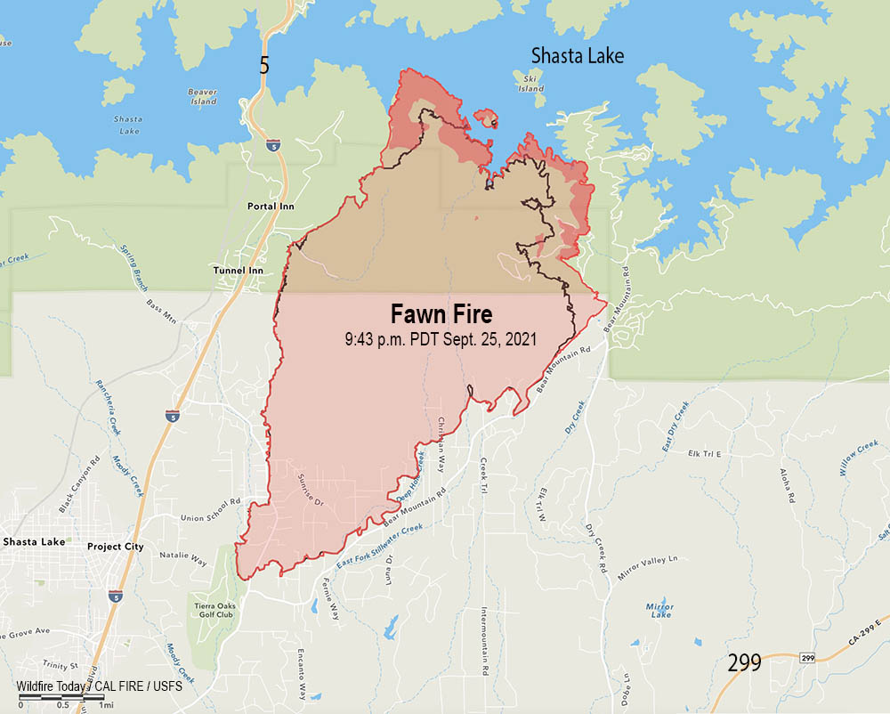
Fawn Fire map. The red line was the perimeter at 9:43 p.m. PDT Sept. 25, 2021. The black line was the perimeter about 24 hours earlier. The darker red areas indicate intense heat when the fire was mapped.
The Fawn Fire north of Redding, California grew by about 1,000 acres Saturday to bring the size up to 8,537 acres Saturday night. All of the growth was on the north side where it reached the shore of Shasta Lake west of Ski Island, and on the northeast side near Bear Mountain Lookout Road and west of Silverthorn Road.
For the second time it spotted across the lake onto an island, which is 500 to 1,000 feet away from the mainland. However with the lake as low as it is, that distance may be much shorter, or non-existent.
Below is a zoomed-in archived satellite photo overlaid with areas of intense heat in red.
North edge of the Fawn Fire, mapped at 9:43 p.m. PDT Sept. 26, 2021
Fire officials report that 131 structures have been officially documented as destroyed, with 44 of them being residences. CAL FIRE Damage Inspection Teams are still assessing the affected areas.
Starting late Monday morning, there is a chance for rain through mid afternoon Tuesday. Unfortunately, this will only produce 0.1 inch over the fire area, but the increased moisture should moderate fire behavior.
Looking toward the Fawn Fire from the Highland Trail camera pointing northwest at 9:08 a.m. Sept. 26, 2021. AlertWildfire.
Resources assigned to the fire include 12 helicopters, 201 engines, 46 dozers, 30 water tenders and 49 hand crews for a total of 1,886 personnel.
9:25 a.m. PDT September 25, 2021
Fawn Fire map 9:21 p.m. PDT Sept. 24, 2021. The dark red areas had intense heat when the fire was mapped Friday night.
The Fawn Fire has burned approximately 25 residences and 75 other structures just north of Redding, California according to fire authorities. When it started Wednesday afternoon it grew very rapidly but slowed after reaching the north-facing slopes above the shore of Shasta Lake. Friday night it was mapped at 7,544 acres and was active on the west side near Radcliff Road and on the northeast side west of Juniper Drive and Bear Mountain Lookout Road.
Saturday morning live cameras showed very dense smoke in the area which would prevent aircraft from assisting firefighters on the ground.
A map showing the evacuations that are in effect is available at the Redding website.
Friday night the fire was four miles north of Highway 299 and was east of Interstate 5 and a large powerline right-of-way east of the Interstate. It was north of Bear Mountain Road.
Alexandra Souverneva. Photo by Roseburg Police Dept..
Fire investigators arrested 30-year old Alexandra Souverneva of Palo Alto, California for starting the fire. She was booked into the Shasta County Jail charged with arson and a special allegation for starting a fire during a state of emergency.
KRCR reported that Souverneva was seen in the general area where the fire started earlier in the day. When questioned by investigators while the fire was burning she was carrying a lighter and said she was hiking because she was trying to get to Canada.
[Souverneva] said she was thirsty and had found a puddle in a dry creek bed but that it contained bear urine. She said she tried to filter the water using a tea bag but that didn’t work so she tried to start a fire to boil the water. She said it was too wet to start a fire so she drank the water and continued walking uphill.
Souverneva is suspected of starting another fire in the nearby city of Shasta Lake on September 21.
On September 12, 2021 Souverneva was arrested in Oregon, for Criminal Trespass, 2nd Degree according to the Douglas County Sheriff. She was released the following day.
(Update Sept. 27, 2021: CBS has what looks like the entire transcript of the piece that aired Sunday night.)
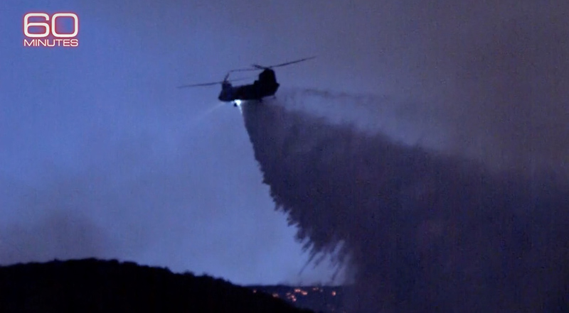
Sunday September 26 at 7 p.m. EDT 60 minutes will broadcast a piece about the very large helicopters being used in Southern California this year. They interview Brian Fennessy, Chief of the Orange County Fire Authority about the Quick Reaction Force that has been partially financed with nearly $18 million from Southern California Edison since June 15 this year.
This group of helicopters includes two 3,000-gallon Boeing CH-47D Chinooks based in Los Angeles and Orange Counties, a Sikorsky S-61 with a 1,000-gallon tank in Ventura County, and a Sikorsky S-76 to provide intelligence, evaluate effectiveness of drops, and identify targets with a laser designator. They are all crewed 24/7 and can hover refill with water or retardant at night assisting firefighters whenever they are needed. The helicopters are operated by Coulson Aviation and have either internal or belly tanks.
On August 18 they were dispatched to assist on the Caldor Fire, working out of Amador County Airport, also known as Westover Field.
Chief Fennessy believes in prompt, aggressive, initial attack of fires.
Reporter Bill Whitaker said to the Chief, “If somebody calls 911 you hit it with everything you’ve got. You knock it out.”
“In case of fire break glass!” the chief replied.
This is not the first time a privately owned Chinook has been used in California. In 2020 one operated by Coulson Aviation worked under an 83-day 24/7 contract in collaboration with Southern California Edison (SCE) and the Orange County Fire Authority (OCFA). Other Chinook operators used on fires that do not fly at night include the California National Guard, Billings Flying Service, Helimax, and Columbia.
The video below is a preview of the Sunday program.
Below is an excerpt from a CBS article about the helicopters:
“[Chief Fennessy said] the ability to lay retardant line, to continue to drop fire retardant after sundown, that’s a first,” he tells Whitaker. And there’s an added advantage: the fires usually die down at night because of decreased wind and increased humidity.
Wayne Coulson, the CEO of Coulson Aviation, is a pioneer in night firefighting. His company built the fleet with its specially designed tanks that carry either water or retardant. Computers control the tank’s doors, opening and closing at precise GPS locations.
“We can fly the aircraft to those GPS points and the doors will automatically open and close between those points,” Coulson says.
On the KNP Complex of fires in Southern California
10:58 a.m. PDT Sept. 24, 2021
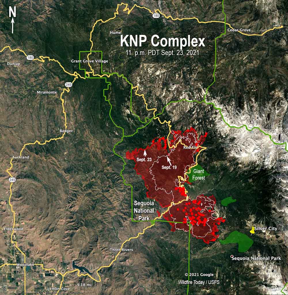
KNP Complex of fires map. The red line was the perimeter at 11 p.m. PDT Sept. 23, 2021. The white line was the perimeter Sept. 19. The green areas are the approximate locations of giant sequoia groves.
One of the highest priorities on the 36,850-acre KNP Complex of fires in Sequoia National Park other than protecting the giant sequoia trees is stopping the south edge of the fire before it gets to Mineral King Road, the location of many structures. On Thursday there were five hotshot crews and a dozer building fireline on the perimeter from Oriole Lake to the east to tie it in with rock. This is not far from the Oriole and Atwell Groves of sequoias. Aircraft supported this operation to reduce the fire’s intensity, enabling firefighters to work closer to the edge of the fire. They expect to complete this section of line on Friday.
To see all of the articles on Wildfire Today about the KNP Complex of fires, including the most recent, click HERE.
In recent days the fire spread closer to the National Park Service facilities in the Ash Mountain area, including the helibase and park headquarters. After weeks of planning and preparation, on Thursday firefighters conducted a tactical firing operation north of the Generals Highway to remove fuel and help protect the structures. They reported it went well. Weather permitting, on Friday firefighters will conduct a similar operation south of the highway not far from park headquarters. The smoke will again be very visible from Three Rivers. Tying all this in will be key to preventing further westward movement of the fire toward park HQ and the communities along the highway.
KNP Complex of fires. Firing operation above park headquarters, Sept. 23, 2021. Looking toward Fry Point from Ash Mountain Headquarters. NPS photo by M. Theune.
In a Thursday morning briefing Operations Section Chief Jon Wallace said he did not have enough hand crews and other resources to be able to work on all of the high priority areas at the same time, and is forced to shift them around based on fire activity.
Roads in shaded fuel breaks on National Forest land northwest of the fire were being re-opened Thursday by 17 dozers. This will allow firefighters access if the fire moves into the area. Other fuel treatments in the park, including a long history of prescribed fire, have been very effective in slowing the spread of the fire, Mr. Wallace said.
A dozer improved the fire road from Ash Mountain to North Fork on Sept. 19, 2021. NPS photo by Mark Garrett.
The General Sherman tree and all of the other giant sequoias are still standing in the Giant Forest. The fire moved into the grove a fairly short distance before firefighters were able to stop it in that area.
A drone is being used to help ignite burnout operations on the north side of the fire west of Little Baldy.
A mobile retardant base is now operational north of the fire at Meadows. Helicopters will be loaded there with fire retardant and gel to slow the spread of the fire in the sequoia groves, assisting firefighters on the ground.
Resources assigned to the fire include 49 hand crews, 58 fire engines, 28 dozers, 35 water tenders, 11 masticators, and 21 helicopters for a total of 1,620 personnel.