In March investigators with CAL FIRE determined that the Zogg Fire which burned 56,338 acres, destroyed 204 structures, and caused four civilian fatalities, was caused by a tree contacting a power line operated by Pacific Gas and Electric (PG&E). On Friday the company was charged with manslaughter and other charges.
Shasta County District Attorney Stephanie Bridgett announced the 31 charges, including 11 felonies, against PG&E, saying it failed to perform its legal duties and that its “failure was reckless and criminally negligent, and it resulted in the death of four people.”
If the utility is convicted of manslaughter, the punishment would be a fine for each person killed in the Zogg Fire last year southwest of Redding, California.
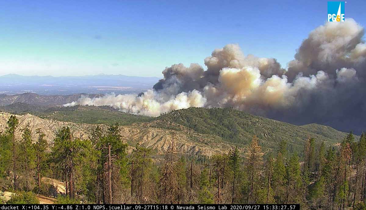
Zogg Fire soon after it started, looking east from Ducket at 3:32 p.m. PDT Sept. 27, 2020. AlertWildfire.
Last year PG&E pleaded guilty to 84 counts of involuntary manslaughter for starting the Camp Fire which destroyed most of the town of Paradise and became the deadliest wildfire in the U.S. in more than a century.
The company has admitted that their equipment may have ignited the Dixie Fire which has burned more than 600 residences and 963,000 acres near Susanville, California. At least two firefighters died of COVID-19 while assigned to the fire.
The fire caused four fatalities and burned more than 56,000 acres in Northern California last year
Zogg Fire, Sept. 27, 2020. CAL FIRE photo.
CAL FIRE has determined that last year’s Zogg Fire was caused by a pine tree contacting power lines owned and operated by Pacific Gas and Electric (PG&E) in Northern California.
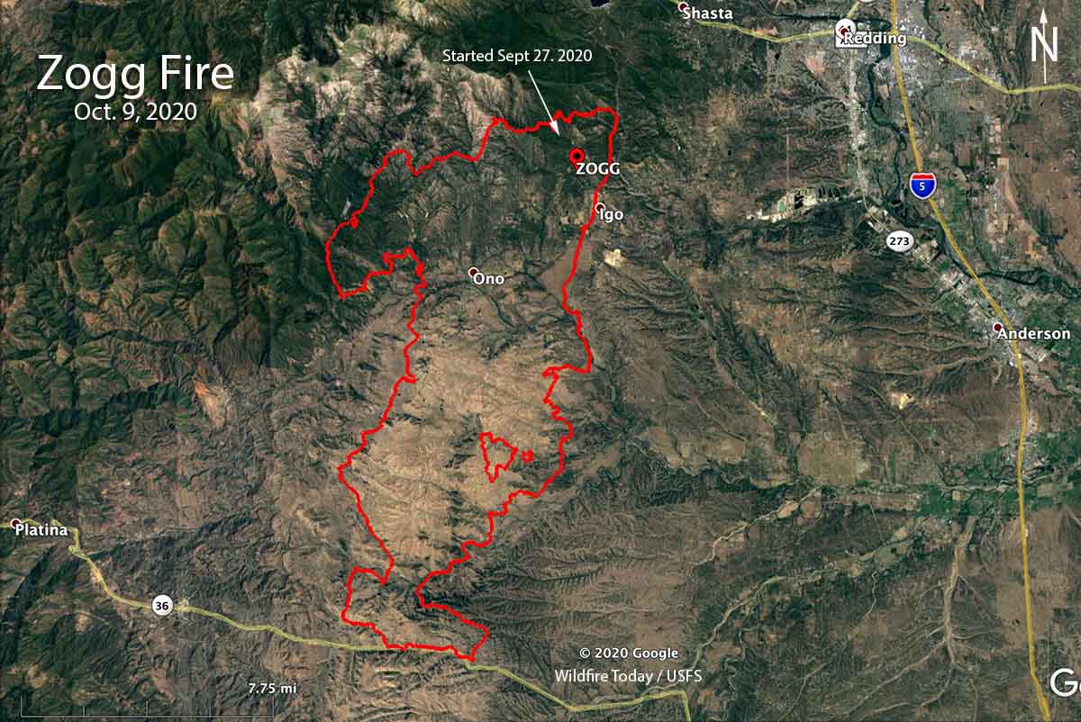
The fire started in Shasta County near the community of Igo September 27, 2020 and burned 56,338 acres, destroyed 204 structures, and caused four civilian fatalities.
The Zogg Fire investigative report has been forwarded to the Shasta County District Attorney’s Office.
The fire spread quickly as strong winds out of the north-northeast pushed the fire toward Highway 36 where firefighters were able to stop it before it crossed the road. The blaze was burning while many other fires were being fought by thousands of firefighters in California and Oregon, causing resources to be stretched thin.
“The loss of life and devastation in the communities impacted by the Zogg Fire is tragic, and we recognize that nothing can heal the hearts of those who have lost so much,” PG&E said in a statement. “We also thank the courageous first responders who saved lives, protected property and worked to contain and put out the fire.”
From the Sacramento Bee:
The determination [of the cause of the fire] came as no surprise, as investigators zeroed in on PG&E as the fire was being fought. Investigators at the time seized PG&E’s power equipment, and the company disclosed in October that damages from the Zogg Fire could exceed $275 million.
Those costs would come on top of the $625 million in potential claims from the 2019 Kincade Fire, which investigators say was caused by a faulty PG&E transmission line. Separately, PG&E agreed to pay $13.5 billion to cover uninsured losses from the 2018 Camp Fire and the 2017 wine country fires.
The horrific fires of 2017 and 2018 drove PG&E into bankruptcy. It emerged from reorganization last summer after pledging to Gov. Gavin Newsom that it was overhauling its operations and leadership to put a greater emphasis on wildfire safety.
PG&E pleaded guilty to 84 counts of involuntary manslaughter on June 16, 2020 for the 84 people that were killed during the Camp Fire that devastated Paradise, California November 8, 2018. The fire burned 154,000 acres and destroyed more than 18,000 structures.
Four people died in the fire southwest of Redding, California
Map of the Zogg Fire October 9, 2020.
Investigators from the California Department of Forestry and Fire Protection looking for the cause of the Zogg Fire seized Pacific Gas and Electric equipment, the utility said Friday in a notification to the state Public Utilities Commission.
The Zogg Fire started about 9 miles southwest of Redding, California during hot, dry, and windy conditions on September 27, 2020 and ran south for 16 miles until firefighters were able to stop it at Highway 36 about 9 miles east of Platina.
Four people were killed in the fire and 103 residences and 101 other structures were destroyed. The estimated costs of suppressing the fire through October 9 are $29 million.
In PG&E’s filing to the PUC, the company said their equipment reported alarms and other activity in the area of Zogg Mine Road and Jenny bird Lane between approximately 2:40 p.m. and 3:06 p.m. on September 27, when the line recloser de-energized that portion of the circuit. The filing says wildfire detection cameras and satellite data showed heat or signs of smoke at that location between approximately 2:43 p.m. and 2:46 p.m.
BakersfieldNow has information about the four fatalities.
The Shasta County Sheriff’s Office identified one of the victims as Alaina Michelle Rowe, 45, who was found dead along a road on Sept. 28. The sheriff’s department said another victim was a minor but did not report the identity. KRCR-TV in Redding reported that Rowe and her eight-year-old daughter Feyla died as they tried to escape the fire.
The two other victims, also found a day after the fire started, are Karin King, 79, who was found on the road where the fire started, and Kenneth Vossen, 52, who suffered serious burns that day and later died in a hospital.
Neither PG&E or CAL FIRE have disclosed exactly what equipment the investigators seized.
CAL FIRE has not released their findings about the cause of the Zogg Fire.
After their equipment was blamed for starting the Camp Fire, in June of this year PG&E pleaded guilty to involuntary manslaughter for the 84 people that were killed when the fire burned through Paradise, California November 8, 2018. The fire also burned 154,000 acres and destroyed more than 18,000 structures. As part of the investigation for that fire, CAL FIRE personnel seized electrical equipment on or near a 100-year old PG&E transmission tower near the point of origin.
Previously the power company has reached settlements with victims from wildfires in 2015, 2017 and 2018, totaling about $25.5 billion, NBC news reported.
Map of the Zogg Fire. The red line was the perimeter at 9:30 p.m. PDT Sept. 30, 2020. The white line was the perimeter about 24 hours before.
Four people have died and 74 residences plus 73 other structures have been destroyed in the Zogg Fire southwest of Redding, California. The fourth fatality was announced by fire officials Wednesday. A person was found badly burned and was pronounced dead after being transported to a hospital.
CAL FIRE said Thursday morning the blaze has burned 55,303 acres.
The fire was not as active Wednesday has it had been in recent days. Most of the spread was on the northwest and southeast sides. Crews completed firing operations along critical sections of the fireline. Live fuel moistures in the area are at a very low critical level, about 60 percent, and the 1000-hour time lag dead fuel moistures are 7 percent. The lower the fuel moisture, the faster a fire spreads. Kiln-dried lumber is usually at about 12 percent.
To see all articles on Wildfire Today about the Zogg Fire, including the most recent, click here.
The weather forecast for the Zogg Fire Thursday calls for 100 degrees, 6 to 9 mph winds out of the northwest in the morning switching to northeast in the afternoon, with 7 percent relative humidity.
The dry fuels with the hot and dry forecast has led to a fire behavior forecast if there is a slopover or spot fire, for rates of spread of around 1 mph and a spotting distance of up to half a mile.
Resources assigned include 133 fire engines, 52 water tenders, 13 helicopters, 31 hand crews, and 37 dozers for a total of 1,538 personnel.
Map of the Zogg Fire. The red dots represent heat detected by a satellite at 3 a.m. PDT Sept. 29, 2020. The red line was mapped by a fixed wing aircraft at 1:30 a.m. PDT Sept. 29, 2020.
CAL FIRE reports that the Zogg Fire southwest of Redding, California has killed three people and destroyed 146 structures.
The fire has burned at least 40,317 acres.
To see all articles on Wildfire Today about the Zogg Fire, including the most recent, click here.
Map of the Zogg Fire at 2:05 a.m. PDT Sept. 28, 2020.
A 2 a.m. mapping flight on Monday by a fixed wing aircraft determined that the Zogg Fire had spread south-southwest for about 14 miles and east for about one mile. It had come to within three miles of reaching Highway 36 the south end. The fire was very active at that time. It was first reported near Zogg Mine Road and Jenny Bird Lane, north of Igo.
The overnight flight mapped it at about 27,000 acres.
To see all articles on Wildfire Today about the Zogg Fire, including the most recent, click here.
Evacuations are in effect, including an area west of Redding, according to KRCRTV:
Update as of 7 a.m.: Areas west of Redding are under a mandatory evacuation order for the Zogg Fire. This includes Muletown Road from Placer Road north to Kanaka Lane. Diggins Way from Placer to the North is being evacuated, as well as all roads off Diggins Way and Muletown Road.
Around 4 a.m., the Redding Police Department posted on Facebook that the fire was no immediate threat to Redding.
The north end of the Zogg Fire not far from where it started. Photo from West Peak at 8:33 a.m. PDT Sept. 28, 2020.
The weather forecast predicts for Monday 14 to 16 mph winds out of the north gusting to 24, with relative humidity of 12 percent in the afternoon.
The map shows heat on the Zogg Fire detected by a satellite at 3 p.m. PDT September 27, 2020.
The map above shows heat on the Zogg Fire detected by a satellite at 3 p.m. PDT September 27, 2020. Since then the fire has spread significantly to the south or southwest across Platina Road.
CAL FIRE reported at about 7:35 p.m. Sunday that the Zogg Fire southwest of Redding, California had burned about 7,000 acres.
Updated September 27, 2020 | 7:03 p.m. PDT
Air tankers currently working on the Zogg Fire southwest of Redding, California include four S-2s, three large air tankers, four military C-130 MAFFS, and two super scoopers.
Initiation and rapid development of #ZoggFire shown in 24 fps time-lapse video from #WestPeak1 camera. Time shown from 2:40 pm to 4 pm PDT. Ridge is about 3.8 km WSW from the camera, just north of Igo, California. Smoke first appears on camera at 2:43 pm. Via @jamesinho. pic.twitter.com/y7T74gqKZq
Map showing the location of the Zogg Fire at 3:30 p.m. PDT Sept. 27, 2020.
The Zogg Fire that started southwest of Redding, California at about 2:40 p.m PDT Sunday September 27 spread rapidly to the southwest Sunday afternoon. It was reported about a mile north of Igo, 8 miles west of Highway 273, and five miles south of Whiskeytown Lake.
At 4 p.m. a spot fire was observed near Platina Road and Newscott Lane, about three miles southwest of where the fire was first reported.
By 5:10 p.m. it had burned 1,000 acres, according to CAL FIRE.
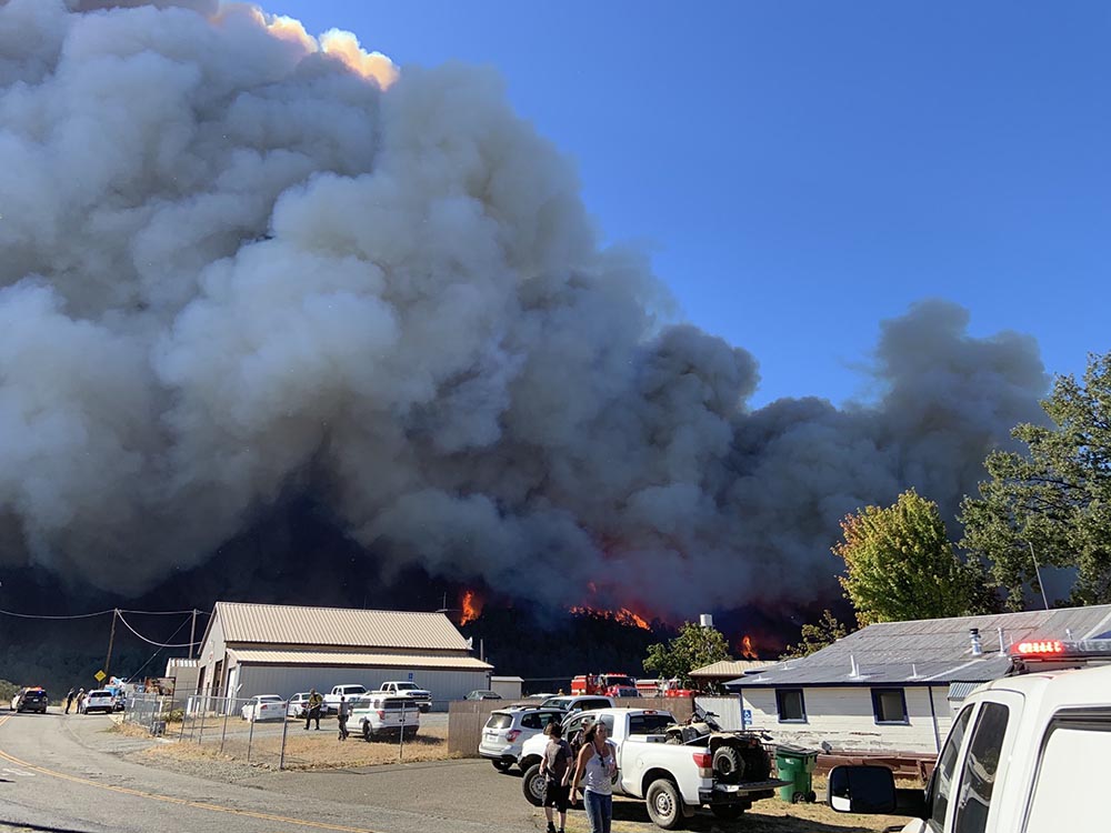
Zogg Fire, looking east from West Peak at 3:46 p.m. PDT Sept. 27, 2020. AlertWildfire.
Zogg Fire, looking east from Ducket at 3:32 p.m. PDT Sept. 27, 2020. AlertWildfire.
The National Weather Service has issued a wind warning for the area, for 15 to 25 mph northeast winds gusting to 40 mph, or up to 60 mph in isolated locations.